
US Department of Transportation
FHWA PlanWorks: Better Planning, Better Projects
| Key Decisions | Framework Applications |
|---|---|
Colorado US 285 – Foxton Road to Bailey
Using Context Sensitive Solutions Approaches to Highway Capacity
Executive Summary
The US 285 project looked at expanding a 14.7-mile segment of mountainous highway southwest of Denver from two to four lanes. The project could have had major environmental issues, but an experienced project team applying context sensitive solutions (CSS) carried out an efficient and quick process of planning and development that avoided major impacts to the environment, reduced the level of NEPA documentation, and saved time and money.
The US 285 project was a highly successful example of planning and development of additional highway capacity, a view shared by partners and stakeholders including the Colorado DOT, FHWA, USEPA, the Sierra Club and others. The project participants attribute the project’s success to:
- A flexible team of designers;
- A proactive and knowledgeable environmental consultant;
- Early collaboration with, and input from, agencies and interest groups;
- Early identification of natural and cultural resource and community issues in a feasibility study;
- Recognition of the benefits that could accrue from an efficient, collaborative process; and
- Continuity of project team and contact with the public, NGOs, and concerned agencies over the course of multiple studies and projects in the area.
The project planning process combined project development, environmental review, and solution screening into a single interactive and highly collaborative process. A corridor feasibility study led directly into a NEPA study of the segment from Foxton Road to Bailey. As a result of integrated planning, the NEPA documentation for the project was reduced from an environmental impact statement (EIS) to an environmental assessment (EA). Drawing from the lessons and groundwork of nearby highway projects, proactive outreach to community interest groups, and broad public support for widening the roadway, the US 285 project became an award winning example of context sensitive solutions and efficient planning and development.1
The success of the project was related to various project strategies and concepts captured in the theme of CSS. Primary among these was a serious engagement of the community, agencies, and other organizations into a collaborative decision-making process. The project held over 80 public meetings and workshops. These included a broad and inclusive value engineering (VE) process. There was a commitment from the start to environmental stewardship. Mergers of multiple regulatory processes were enacted, and multi-agency “fieldtrips” resulted in consensus solutions and transparent decisions. In addition to these collaborative principles, the project gathered large-scale environmental information early to support planning level decision making. All these processes were aided by a flexible and positive attitude among the project teams.
Transportation needs were met to the full extent by increasing through-lane capacity from two lanes to four, providing access control, and improving substandard design elements. These safety and capacity improvements required a much larger footprint along US 285, but the designs were developed in a way that avoided impacts, and had strong support from stakeholders. Measurable cost savings are estimated at over $59 million, and other benefits include exceptional public support, environmental protection, reduction in accidents, and reductions in travel time.
Background
Project Overview
Highway expansions are often controversial, especially in areas known for their scenic beauty, historic resources, and wildlife. The US 285 capacity improvement project examined how to expand a safety-challenged two-lane road into a four-lane highway, through a scenic area. The US 285 corridor is one of two routes to the mountains from the Denver metropolitan area, the other being I-70. Before the advent of the highway system, the road was a more important thoroughfare between Colorado, New Mexico, and Texas, but since that time has become a scenic corridor eclipsed by other major interstates. The road is classified as a Regional Highway (R-A) / Non-Rural Principal Highway (NR-A), and the drive southwest from Denver into the Rocky Mountains is a beautiful open setting.
As a conduit for recreational traffic the road is prone to weekend bottle-necks. Slowing recreational vehicles on mountainous slopes and narrow roads offered no room for passing. In addition to recreational use, metro area residents have increasingly settled along US 285 from Foxton Road to Bailey, making it a “bedroom community” of residents who commute to Denver. The need for road widening focused on increasing capacity and safety, with an eye towards these major uses.
The lead agency for the project was the Colorado Department of Transportation (CDOT), in cooperation with the Federal Highway Administration (FHWA). The US Army Corps of Engineers (USACE) participated as a cooperating agency on the NEPA study. The 14.7-mile section of 285 under study extends from Foxton Road, near the town of Conifer, southwest to the town of Bailey, stopping just north of the town. The Foxton Road to Bailey section begins in Jefferson County, a suburban county of Denver, and extends into Park County, which is very rural. In addition to the counties, the project passes through city administrative districts, including the cities of Bailey, Pine Junction, Shaffer’s Crossing, and Conifer. The Jefferson County portion of the highway is within the purview of the Denver Regional Council of Governments (DRCOG), the metropolitan planning organization (MPO) for the city of Denver, but the Park County section is not. Most of the issues related to the highway’s traffic patterns, as well as local community interests, are linked to the status of the highway as a transition from urban to rural settlement within a scenic environment.
Project Drivers
The project was proposed to increase capacity and improve safety, two problems that stem from the road’s age.2 Traffic congestion was common, and the out-dated road technology meant accidents were frequent. In 2000, the average daily traffic volume in the study area was 21,000 (24,000 weekend), and most level of service (LOS) ratings were D or E. The accident rate was double the statewide average for similar facilities.3
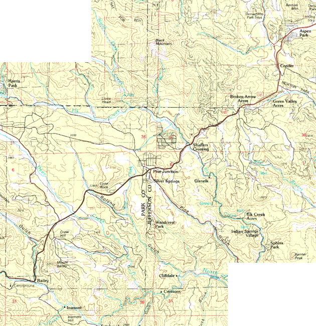
Figure 1. Map Showing US 285 Section from Conifer to Bailey
The project benefited from community support and safety concerns. CDOT and Jefferson County led the effort, but all interviewees for this case study agreed that the community strongly supported widening the road. In discussions between CDOT and county transportation representatives, the widening of US 285 was ranked as the first choice for transportation improvements. The project did not have much “help,” so to speak, from politicians aside from those county administrative choices. As Jefferson County’s first priority, the project was “a slam dunk” for DRCOG funding, and was approved with minimal discussions. A fatal accident occurred on the road during the planning and environmental review, adding urgency to the improvement initiative.
Initial Concept and Planning
The widening of US 285 from Foxton Road to Bailey “was the obvious next step” at the time. Almost unanimously, interviewees described the project as the only option.
From an administrative or planning perspective, the origins of the project are nebulous. The project emerged suddenly out of the larger context of regional transportation, land use, and population changes. In 1985, an EIS was done to explore widening US 285 to four lanes from Denver (CO 470) southwest to Foxton Road, in the area of Conifer. Construction began and as the last of a series of projects finished – the Phase 5 widening from Goddard Ranch Court to Foxton Road (completed in 2002) – traffic capacity projections for the new road were already at their maximum. Another study was immediately necessary to examine widening the road further to the south.
Feasibility Study
In 2000, CDOT Region 1 initiated a feasibility study of a 53-mile corridor of US 285 from Foxton Road to the town of Fairplay, which was completed in 2002.4 If there is an official starting gun for the earliest planning of the Foxton Road to Bailey segment, the initiation of the feasibility study would be it. US 285 was never listed on a long-range plan, and was amended into other transportation plans only after preparation was well under way.
CDOT wanted to look at traffic projections for 25 years on US 285 to ensure that once they completed the next major improvement, the process would not need to be revisited again for some time. The 53-mile feasibility study was intended to facilitate future project needs by identifying traffic volumes and patterns across the US 285 gradient from suburban to rural settlement and use. The study characterized different segments of the roadway based on vehicle use as well as land use and the presence of resources. Additionally, the study identified a wide range of improvement possibilities ranging from small localized enhancements to major widening of segments. The report’s recommendations found that widening the segment from Foxton Road to Bailey to four lanes was the most practical immediate solution for the worst traffic deficiencies.
The feasibility study acted as solutions screening, with the result being to widen the 14.7-mile segment from Foxton Road to Bailey. In 2001 CDOT approved funding to do a NEPA study of the widening from Foxton Road to Bailey, the first official acknowledgement of a distinct project (Project Reference Number: NH 2854–093). The range of potential solutions was limited. The obvious preference was to widen the road. As a mountainous corridor there were few options for alignment change, and project alternatives examined details such as establishing the southern terminus of the project and maximizing avoidance of impacts to environmental resources.
The NEPA process for the US 285 project benefited greatly from the feasibility study. The CDOT project manager intended that resource information from the feasibility study would feed directly into a subsequent environmental impact statement (EIS). Likewise the consultants, Carter & Burgess Inc., had done “an exceptional job” at community outreach. The feasibility study laid much of the groundwork for the project and its success by establishing community focus groups, working with commercial business districts and land use data, and identifying critical resources and issues of public concern. As a result, the earliest conceptual designs were able to avoid environmental resources and address concerns among the public. Stakeholder trust was high, and the project moved forward as a truly collaborative effort to examine transportation solutions.
Drawing on Lessons from Other Highway Projects
There was a larger context to the project development as well, linked to the timing of projects and to lessons learned from other nearby highway projects. The CDOT management team from the feasibility study was the same for the NEPA analysis for the Foxton to Bailey segment, as was the consulting firm. Their efforts benefited from continuity and long term goals. The group considered the fact that an EIS had begun for improvements to I-70, the other main thoroughfare to the mountains west of Denver. The two highways have connections, through mountain passes, and construction on either roadway would significantly impact traffic on the other. There was a possibility that improvements to US 285 could get ahead of the I-70 project if the process was executed efficiently.
The idea of context sensitive solutions was gaining traction among DOTs at approximately the same time. Not far from the US 285 project was another project to reconstruct a mountain pass which the public saw as a complete disaster. The Sierra Club, among others, felt that project failed to take any wildlife considerations into account, and felt FHWA had pushed the project over on the community. Midway along the 285 corridor, the Colorado DNR was planning to improve Staunton State Park. They conducted a traffic study of the intersection of 285 with Elk Creek Road, the park entrance. That project was not particularly wanted by the community, who felt the state park improvements would add traffic to their residential street. The various members of the US 285 project team had watched these issues play out, and were determined to get ahead of potential problems.
The funding of the project also has a larger context related to timing. Around 2000, CDOT had relatively good funding. A statewide initiative called the “7th Pot” had been implemented to fund a list of 28 “strategic” projects. The “pot” was designed to accelerate improvements and minimize regional parochialism in project planning. A referendum in 1999 allowed bonds to be issued for highways, with the proceeds being used to fund 7th Pot projects, and the first bond offering was May 2001.5 The study project from Foxton Road to Bailey was not initially part of the 7th Pot, but the widening of other sections of US 285 south to Foxton Road were (initial planning took place 1970-1975). The supply of federal monies for state highway projects became less predictable in 2001 and 2002 and the overall national economy softened. Many interviewees cited the effects of 9/11 as the cause. In 2003, money was approved from the 7th Pot – estimated at $21 million – to widen a 3.5-mile section of US 285 into Conifer, part of the study project that was originally scheduled to begin in 2004.6 This was an “early action” breakout project that was able to start early as a result of selective financing.
The widening of US 285 was planned amid this context of community concerns and fluctuating agency funding. The NEPA team worked through these issues efficiently to complete the project.
Major Project Issues
Interviewees recalled the project very positively, and rarely called anything a problem. Nevertheless, some issues were raised.
Land Use and Development Issues
The major concerns were related to traffic capacity as well as the overall impacts of a larger roadway on land use and community dynamics in the corridor area. The US 285 corridor, once considered rural Colorado, has increasingly become a distant residential zone for commuters into the Denver metropolitan region. The highway needed additional capacity to accommodate metro commuter traffic. Recreational traffic passing through at peak times increased the demand.
Of bigger concern was the overarching debate in Colorado about sprawl. The ideological question of whether or not highway capacity expansion should continue has played out in Colorado in different ways. Some places, such as Boulder, have devised regulations specifically limiting new road construction. In the case of US 285, debate occurred in the planning phase on whether the widening would encourage development and increase sprawl. The Denver Regional Transportation District (RTD) has a philosophy of Transit Oriented Development (TOD) with four main goals: reducing sprawl and protecting existing neighborhoods; reducing commute times and traffic congestion; improving environmental quality and open space preservation; and encouraging pedestrian activity and discouraging automobile dependency.7 How to reconcile all of these goals for the US 285 project area was the challenge. The widening of US 285, intended to handle the Denver traffic, might facilitate new development along the corridor adding to sprawl.
Environmental Issues
The potential impact of the project on the environment was seen as a manageable issue. The US 285 corridor extends through a mountainous landscape, bordered by wetlands in 44 areas and nine tributary drainages to the South Platte River. It is an area with abundant wildlife, as well as a picturesque aesthetic. High scenic values include mountain views and existing open areas. Water quality concerns and noise and air quality issues were also in evidence.8 The initial project corridor encompassed eight properties that were either on or eligible for inclusion on the National Register of Historic Places.
Impacts to this environment could have been a bigger issue, but the project development team was prepared for that possibility. From the start, CDOT and its environmental consultants had the goal of creating a community-focused project with as little impact to the environment as possible. As a result of the feasibility study, the community was engaged very early in the process – actually before the project concept had been decided. Environmental resource issues had been pre-identified, and were seen as manageable provided the larger concern over land use and the effects of sprawl could be adequately addressed.
Funding
Funding is an issue with many projects, and the US 285 widening was no exception. Funding was seen as the main issue by several interviewees who discussed the US 285 widening. The integrated planning/NEPA phase of the project was clearly a success with the community, but the project emerged from that process without funding for construction. As roadway design was refined, the engineering team looked for places where costs could be reduced. Some of the design elements that were chosen to minimize environmental impacts were modified. In particular one of the wildlife underpasses was removed from the plans. This caused a stir among the various community interest groups, including the Sierra Club. The issue was resolved when the underpass was put back into the plans. Because of the extensive community involvement, the project maintained stakeholder trust despite this episode. Nevertheless, the project remains under funded. The segment from Foxton Road to Richmond Hill has been let out for bid, at approximately $8 million, but the CDOT Annual Report of 2006 does not list the project as fully funded.9
Institutional Framework for Decision Making
The US 285 project was largely a CDOT initiative, with Jefferson County as a major supporter. The lack of a formal decision-making framework for the project may have allowed the creative skills of the project team to come through. CDOT’s Region 1 office started the feasibility study in 2000, and it was conducted by Carter & Burgess.10 As CDOT staff noted, “different regional offices have a lot of autonomy and do things differently.” The CDOT Regional Program Engineer is the person with the greatest authority over decisions and process. As the consultant, Carter & Burgess worked with the CDOT Region 1 environmental staff. All had a practical attitude, could work collaboratively, and were flexible in considering input and options. By at least May 2000, the consultants and CDOT project members were attending community meetings. Likewise, most resource agencies, chambers of commerce, and special interest groups like the Sierra Club had been involved by the spring of 2001. The project team kept up nearly constant community outreach for several years, a defining collaborative element and source of project success.
In March 2002 the feasibility study identified the project area – Foxton Road to Bailey – as a distinct segment in which major improvements were needed. The feasibility study had been funded by the "Region Priorities Program,” in which local governments partner with CDOT to prioritize projects. Discussions between CDOT Region 1 and the counties led to prioritization of the Foxton Road to Bailey project as the first choice for Jefferson County. Even Park County agreed that improvements should occur in Jefferson County first–-a rare occurrence in a process where everyone wants their project prioritized. As Jefferson County’s top choice, the DRCOG likewise prioritized the project. Only a month after the feasibility study had been finalized, in April 2002, the DRCOG issued Metro Vision 2025, an interim regional transportation plan (RTP). Figure 18 showed US 285 from Foxton Road to the Jefferson County line (the section within its jurisdiction) as a Principal 4 lane road, as if the widening project was a forgone conclusion.
Immediately following the feasibility study, funding for a NEPA study of the project area was provided in May 2002, also through the Region Priorities Program. Carter & Burgess was the consulting firm for the NEPA study, as they had been for the feasibility study, and again worked with CDOT Region 1 environmental staff to complete the NEPA process, with FHWA having review authority. FHWA published a Notice of Intent (NOI) to begin an EIS in July 2002.11 The NEPA team of Carter & Burgess and CDOT were holding Steering Group meetings in June 2002 and public workshops by July 30, 2002. The speed with which this involvement was conducted is directly attributable to the feasibility study. This was the case for resource agency collaborations as well.
Resource agencies described their role as relatively minor. CDOT and the consultant knew that wetlands and historic properties would be the biggest resource issues, and with that knowledge, chose to pursue solutions early and collaboratively with EPA, USACE, SHPO, USFWS, and several state agencies. Most of these agencies had already provided data for the corridor feasibility study and had seen preliminary design alternatives for the widening from Foxton Road to Bailey. Two mergers were enacted, one on NHPA Section 106 with the Colorado SHPO and the other for the Clean Water Act and Section 404 with the USACE. Both the USACE and the SHPO were asked to be cooperating agencies in the NEPA study. The USACE accepted the invitation. The SHPO felt their concerns would be adequately addressed without participating in this fashion, but appointed a representative to work with the project team.
The NEPA study examined designs for the Foxton Road to Bailey section that avoided as many environmental resources as possible. There was some discussion between FHWA environmental representatives and CDOT as to whether their EIS needed more alternatives. The decision was made in December 2003 that the EIS should be downgraded, and that an EA would be the better level of NEPA documentation for the project. The early commitment to cooperative and context sensitive solutions had paid off.
In November 2003 the widening of US 285 in Jefferson County was amended into the DRCOG Fiscally Constrained Element of the 2025 RTP, and approved in December 2003 in the TIP for fiscal years 2004-2006. The EA was completed August 11, 2004 and a Finding of No Significant Impact (FONSI) was issued on June 30, 2005.12 The entire section within Jefferson County was identified for widening to four lanes, along with new interchanges, in the Fiscally Constrained Element of the 2030 Metro Vision RTP, released in January 2005. That solved some of the funding issues, and the report also identified US 285 as a “Statewide Connector.” In June 2006, the MPO continued funding in the TIP into fiscal years 2008-2009.
Transportation Decision-making Process / Key Decisions
The US 285 widening from Foxton Road to Bailey was a success largely due to early input and collaborations, as well as strong community support. The development process was iterative and collaborative in its pursuit of context sensitive solution and minimizing environmental impacts. Design and project development were “like one big NEPA process,” and a well-executed one at that.
By utilizing a CSS approach the project attained strong public support and millions of dollars in project savings. Intense community involvement occurred in very early stages of the planning and the design processes, and management teams were flexible and open to suggestion. Transportation engineering and environmental variables were well presented and explained in open public forums, and decisions were transparent. Stakeholders commented that “the documentation doesn't sufficiently convey the extent to which the project was a group effort.”
That said, the range of potential decisions was minimal. There weren’t many possible alternatives in the design, and the planning process was not protracted. The eastern segment of the project area, the portion in Jefferson County, is within the jurisdiction of the DRCOG, but the project had essentially no MPO planning phase. The project moved forward with carefully aligned corridor and NEPA studies initiated by CDOT, but even these were somewhat truncated. For the most part, the decisions were limited to consideration of a variety of interchange design options and minor alignment changes. These options were brought to the public and decisions were collective agreements.
Strong community support for the project kept it moving along. The community support was based partly on the pressing need for transportation solutions as well as how the community was approached and engaged by the project development team. There was a real commitment to achieving all interests, or at least as many interests as possible. This sincere and open attitude fostered trust and collaboration among the various stakeholders.
Feasibility Study
As previously noted, an early key decision in the widening of US 285 was the initiation of the feasibility study, a detailed analysis of a 53-mile corridor of US 285. The feasibility study was initiated by CDOT project management, who had discussed transportation needs with county commissioners.
Early Resource Identification
Most importantly, the feasibility study was designed to feed directly into a NEPA study. It would not simply be a discussion of traffic demand and deficiencies, but was essentially a NEPA study itself. In addition to looking at county population growth and traffic and safety issues, the study compiled a considerable amount of data. It was broad in substance, but not necessarily deep in analysis. The data included reconnaissance level site visits, GIS surveys and mapping, review of previous technical studies and reports, public involvement and agency input, right-of-way and aerial survey mapping, and existing traffic volume data. The feasibility study engaged the USACE on water quality and wetland issues, examined land use and commerce, and the aerial flyover surveys cost over half a million dollars.13 The CDOT Project Manager stated that, “At that time we didn’t know what the benefits could be. Thinking now, the benefits were a lot more than the cost of it. …we were able to downgrade the EIS into an EA - that alone saved us months and months of time.”
Early Extensive Community Involvement, with Ensuing Support
The community wanted capacity increases, but without environmental and visual impacts. Like an EIS scoping process, a website was established for public input on the feasibility study. The project team gathered information on every aspect of potential impact, and themes of public concern were distinguished early in the process.
Innovative Use of Value Engineering
CDOT noted, “This was the first time in Region 1 that we did value engineering this early in the project.” Utilization of this detailed process of interactive and collaborative design modification and refinement at an early stage built significant understanding of the project among the community and consensus on solutions. A multidisciplinary value engineering team was established that included planners and engineers, maintenance staff, local homeowner representatives, and environmental resource agency representatives. The process included as many pertinent people as possible.
The value engineering process was not purely a means of design, but also another method of community involvement. Using high-quality graphics, mostly aerial imagery with overlays, they brought engineering to the public. Corridor residents and business people could understand and discuss the variables involved, and this data sharing and involvement made the decisions transparent. The idea was: “If we make them a bit happier in the beginning …you’re not going to have as many comments later.”
Planning Decisions Designed to Stick
The feasibility study was a decision-making document, complete with alternatives and cost-effectiveness analyses. It had identified the most critical concerns and issues for any roadwork along US 285. The most critical to the public was the wildlife in the area and protecting the scenic mountain vistas of the region. The report recommended many modifications along the 53-mile corridor. An evaluation matrix compared localized improvements, many of which were intersection improvements. Other details of highway operation, such as climbing lanes and rockfall mitigation were also proposed. There were enough traffic and roadway problems in the section from Foxton Road to Bailey that the recommendation was widening to four lanes with either a depressed or grade-separated median.
The continuity in project staff and the relatively short timeframe between feasibility and NEPA studies assisted the public in understanding and building support for emerging solutions. This enabled the team, the community, stakeholder agencies, and NGOs to progressively explore the issues and find solutions, rather than getting bogged down in intransigent opposition or having to revisit earlier decisions.
NEPA Process
The feasibility study led to the decision to pursue widening to four lanes from Foxton Road to Bailey. The NEPA process followed seamlessly from the feasibility study, and was greatly facilitated by the previous analyses. The NEPA process focused on details associated with the widening from Foxton Road to Bailey, but much of the “infrastructure” of that analysis was already in place. The same management staff from CDOT and the same consultant, Carter & Burgess, meant the institutional relationships were the same. The feasibility study had identified the range of potential options for the roadway. The NEPA study conducted more detailed development of remaining alternatives to identify practicality and feasibility from a technical standpoint. CDOT and Carter & Burgess agreed to use some CDOT staff on the project for technical work, depending on availability.14
Willingness to Go “Substantially Beyond” the Normal Procedures for Resource Agencies
Once the NEPA process actually began in July 2002, more formal relationships among agencies were put in place. The NEPA process was the responsibility of CDOT and FHWA, and the relationships and decision making between those two agencies was fairly standard. In terms of the resource agencies, however, the process went “substantially beyond” the normal procedures. The project team knew that wetlands and historic properties were the biggest issues. The USACE was already involved from the feasibility study. Project management also wanted the SHPO to get involved early, so they would not simply be regulatory and reactive. The SHPO declined to be a cooperating agency, partially because they did not want to give false impressions of support before data had been considered, but they contributed to and participated in the NEPA and design process. The project team established a Project Steering Group (PSG) to make recommendations to FHWA throughout the process. The PSG included representatives from CDOT, FHWA, RTD, Jefferson County, Park County, DRCOG, and the consultant team.
Extensive, Interactive Public Involvement Including Many Focus Groups and Small Group Meetings
The public cooperation and collaboration is difficult to quantify, but was extensive. CDOT had an old "action plan" for public involvement, but most CDOT Regions structure public involvement around FHWA standards and use various committee structures. For the US 285 widening, the project team established a Land Use Committee, resource agency team, transit feasibility working group, and many other focus groups. The project had over 80 public meetings. There was consensus on the need for widening the highway, but “the devil was in the details." The focus groups were organized, to some extent, in terms of resources and decisions. The Land Use Committee began meeting as early as 2001 to plan for maximum build-out, and included county representatives, chambers of commerce, homeowners associations, and community groups. A citizen’s advisory group focused on the design planning. The consultants and project management team facilitated large public meetings, as well as smaller meetings with neighborhood, property owner, business, and special interest groups. The project regularly sent newsletters to over 800 people, and the website received 6,400 hits.
In addition to the aerial imagery, communications methods included visual simulation, both computerized and artist renderings, as well as displays of alternatives for retaining wall textures and designs. CDOT and the consultant extended special effort in reaching out to low-income and minority communities. Some input was solicited from the public in the form of comment forms and mail-in surveys. With the website and the multitude of meetings there was no set schedule and very few barriers to submitting comments and opinions.
Anticipating Issues and Incorporating Feedback
The Sierra Club had been stunned by another big project in the area. They came to the US 285 project organized and in force, only to find CDOT Region 1 very open to environmental concerns and transparent decision making.
The Sierra Club and the Colorado Division of Wildlife were closely involved in the project, along with the Preserve Our Mountain Community Group. When the NEPA scoping started, a number of agencies and stakeholder groups anticipated there would be a big threatened and endangered species issue with lynx. Lynx was mentioned in early public comments and their habitat has at various points been considered to cover most of the state’s mountainous area, especially south of I-70. Research for the US 285 project found the area was not a lynx habitat, eliminating the need for “an all out biological assessment.” Migratory elk factored into planning considerations, but the designs had anticipated this and included 12-foot underpasses for elk. The area was not considered a major elk migration route anyway. One interviewee commented that they were pleased to find CDOT “recognized the extant literature on wildlife and had already planned on doing underpasses.” In one part of the project area the original construction of highway 285 had filled in a gulch to support the roadbed, but the designers took that out and made it a bridge instead, restoring the previous sloped setting, habitat connection, and wildlife passage that once existed there.
Early Resource Agency Involvement While Decisions and Designs Were Fluid
Resource agency staff were engaged early in the process while decisions and designs were still fluid and alternatives were still being developed. Scoping meetings always included representatives from the EPA, USFWS, Colorado Division of Wildlife, USACE Tri-Lakes project office, USFS, Colorado Department of Public Health, Colorado SHPO, and others. These resource managers were participants in the same integrated involvement process that included the public, the engineers, and the planners.
Solutions Generated Cooperatively in the Field Led to Consensus
The involvement of resource agencies was not particularly innovative or high-tech, but did include fieldtrips. The consultant team got representatives from the USACE, EPA, the SHPO, and CDOT to visit specific locations together to discuss potential solutions. Consensus solutions evolved from there: “The wetlands biologist had the SHPO representative looking over his shoulder, so each knew why he had to budge one way or the other.” “We were able to chat about whether resources might be [significant] or not.” “The designers had 12-foot underpasses for the elk migrations, which impacted wetlands but the Corps guys agreed it was the best trade-off and the wildlife underpasses should be built.”
Design teams were able to work around most environmental resources. The project avoided 44 wetland sites (a total of three acres), and eight historic properties. It designed around nine tributary drainages and built five large wildlife crossings or underpasses. The counties, especially Jefferson, have very robust GIS systems and provided data layers for designers.
Figure 2. Map Showing Wildlife Analyses and Planned Crossings
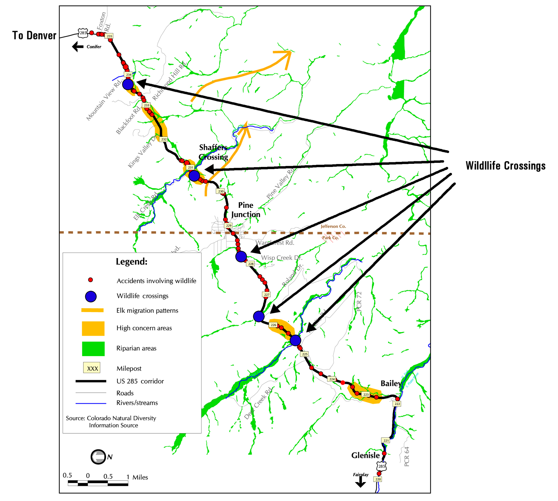
Source: from Gaskill, Craig, Cost-Benefit Study of Applying Context Sensitive Solutions to US 285, West of Denver, Colorado. Transportation Research Board Annual Meeting, 2007. Paper #07-0098.
Data and Modeling of How the Changes Would Affect Community Members
The NEPA study also included a lot of data and research on traffic patterns and land use. GIS modeling techniques were used to evaluate travel times, actual versus posted speeds, access points, and the locations of environmental resources. The analyses used the DRCOG traffic demand forecast data, which uses a Delphi technique for anticipating land use changes. CDOT provided annual average daily traffic (AADT) volumes for 1990-2002. The firm Counter Measures Inc. conducted average daily traffic (ADT) volume assessments in summer 2000. More specific intersection data was gathered during the summer of 2002 for design purposes. Vehicle speed and queue data was collected with a GPS receiver. Traffix software was used to simulate projected growth scenarios, and Park and Jefferson Counties provided the zoning and development data for access points. The accuracy of Traffix was calibrated using a combination of 24-hour and peak figures, which were compared to the volumes generated by the DRCOG. This was all guided by consulting the Institute of Transportation Engineers (ITE) Trip Generation Manual, 6th edition.
The two counties provided population data, as well as zoning, and potential re-zoning, information. This was used to build a profile of county growth patterns and business needs, and to align the objectives of these groups. Other plans, both long-range development plans and other major projects, were closely examined, and included the CDOT Bicycle Corridors report of 2000, and the USFS State of Colorado Wildfire Hazard Mitigation Plan (2001); Jefferson County Mountain Groundwater Resource Study; Jefferson County Open-Space Master Plan; Park County Land Use Regulations; 2002 Park County Profile; State of Colorado Wildfire Hazard Mitigation Plan (2001); the EIS from 1986 for the section of 285 to the northeast; and the Guanella Pass Road Supplemental Draft EIS and traffic study.
Value Engineering and Small and Large Public Meetings Led to Design Adjustments to Improve Aesthetics and Reduce Costs
The value engineering team met for a week to review alternatives and recommend changes. They also held three public workshops on project design. An interesting turn of events occurred at one of the public neighborhood meetings. “During a public meeting, one of the residents came and said ‘oh they are putting an interchange… I live right there, and I don’t want to see that bridge.’ I said ‘we can come to your neighborhood and have a meeting…” From the meetings, it was determined that the public did not want this interchange. “We gave them all the data. The majority of the people who were going to use the interchange said ‘no, we don’t want to see it.’” As a result, an entire interchange at Wisp Creek was completely eliminated from the design.
The majority of the process is best characterized as design refinement. Some of the primary design controls were pre-determined to a degree. Earlier phases of widening that had taken place on US 285 from Denver south to the project area shaped driver expectations; in order to be safe, this section had to match the design speed and driver expectations of other sections of the road. Most of the US 285 corridor is consistent with CDOT's "Rolling" designation, which requires a design speed of 60 mph (CDOT Design Guide 1995). For this project, design was probably 15-20 percent for the NEPA process; “there are some projects where, in order to determine the right solution, you don’t need a lot of design.”
Curbing Sprawl through Access Control and Intersection Design
The other main issue, one of the biggest among the community and the planning organizations, was the potential for sprawl, or induced growth. Traffic data showed that widening the road to Bailey would solve foreseeable traffic for 20 years. That established the physical limits of project. The local governments supported the project for commuting and congestion relief, but did not want to encourage sprawl. A Transit Feasibility Working Group and a Land Use Committee helped develop land use forecasts and determine levels and locations for induced growth. The Land Use Committee for the feasibility study also resulted in the 2001 Strategic Master Plan for Park County. The NEPA study examined that data, as well as the Conifer/285 Corridor area Community Plan (1987 but revised 2002) and the 2002 Park County Profile, Demographic and Economic Overview. CDOT was able to convince the DRCOG that carefully designed access points would limit sprawl. The idea was that widening would facilitate traffic flow, but the design of the access points would restrict the ability to develop surrounding land. Access times for each driveway and public road, the turning movement conflict points, and visual simulations were all modeled in GIS.
Final NEPA Considerations and Decisions
In the fall of 2003, as the preferred alternative was being developed, CDOT environmental staff consulted FHWA on the progress of the US 285 EIS document. FHWA recommended that CDOT develop more alternatives to have an adequate EIS. One interviewee for this case study recalled a legal ruling against FHWA in San Francisco as the impetus for this, but the circumstances are unclear. According to most of the project team, there weren't a lot of options. As an existing mountainous highway, the alignment could be shifted only slightly. Additionally, FHWA, CDOT, EPA, and the USACE found ways to avoid impacts.16 It was agreed upon that an EA would be the better level of documentation. In December 2003 the environmental study was downgraded to an EA.
It was at approximately the same time that the project was partially funded by the DRCOG. Half of the project area is within the range of the Denver MPO, the DRCOG, but they had their attention focused on larger projects like T-REX. The DRCOG only began to plan for the project in the fall of 2003, after much of the initial conceptual and environmental work was completed. The project was still a CDOT initiative.
Perhaps the most important element in the NEPA process was the determination of termini for the capacity improvement project. The alternatives in the documents included projects like a Bailey bypass to keep highway traffic out of the town. The traffic projections, however, indicated that enough cars exited the roadway prior to Bailey that a bypass was unnecessary at this time. Future planners could make that decision if necessary. The preferred alternative from the EA included widening to four lanes from Foxton Road to beyond Crow Hill, a very steep section just north of Bailey. Some intersection improvements would be done in the town of Bailey to smooth the flow of traffic.
Another consideration was the design of the median. The footprint of the four lane roadway could be made narrower with a barrier median. The depressed median, however, provided a better crossing for wildlife. A depressed median was also less imposing to the eye. The public had strongly expressed the desire that the highway try to maintain the overall aesthetic of the rural mountainous landscape, uninterrupted by concrete barriers. The depressed median was preferred for that reason. Grade-separated interchanges were designed along the same principles. Unlike traditional diamond interchanges, the grade-separated interchanges on this project follow the contours of the mountainous land. Incorporating this into the design reduced the total turning movement conflict points by more than 75 percent.17
There were few deliberations on alternatives. The resource agencies and a high proportion of the community had participated in developing the plans, and by the point at which alternatives are normally compared and contrasted, no one had any objections. “There was really only one alternative - widen the road.” In the end, mitigation considerations were not a large part of the process because there was no need. As a result of the CSS-driven value engineering process and the early identification of resource areas, the project had very little impact. The Environmental Assessment was completed in August, 2004 and a FONSI issued on June 30, 2005.
Figure 3. Rendition of Grade-Separated Intersection
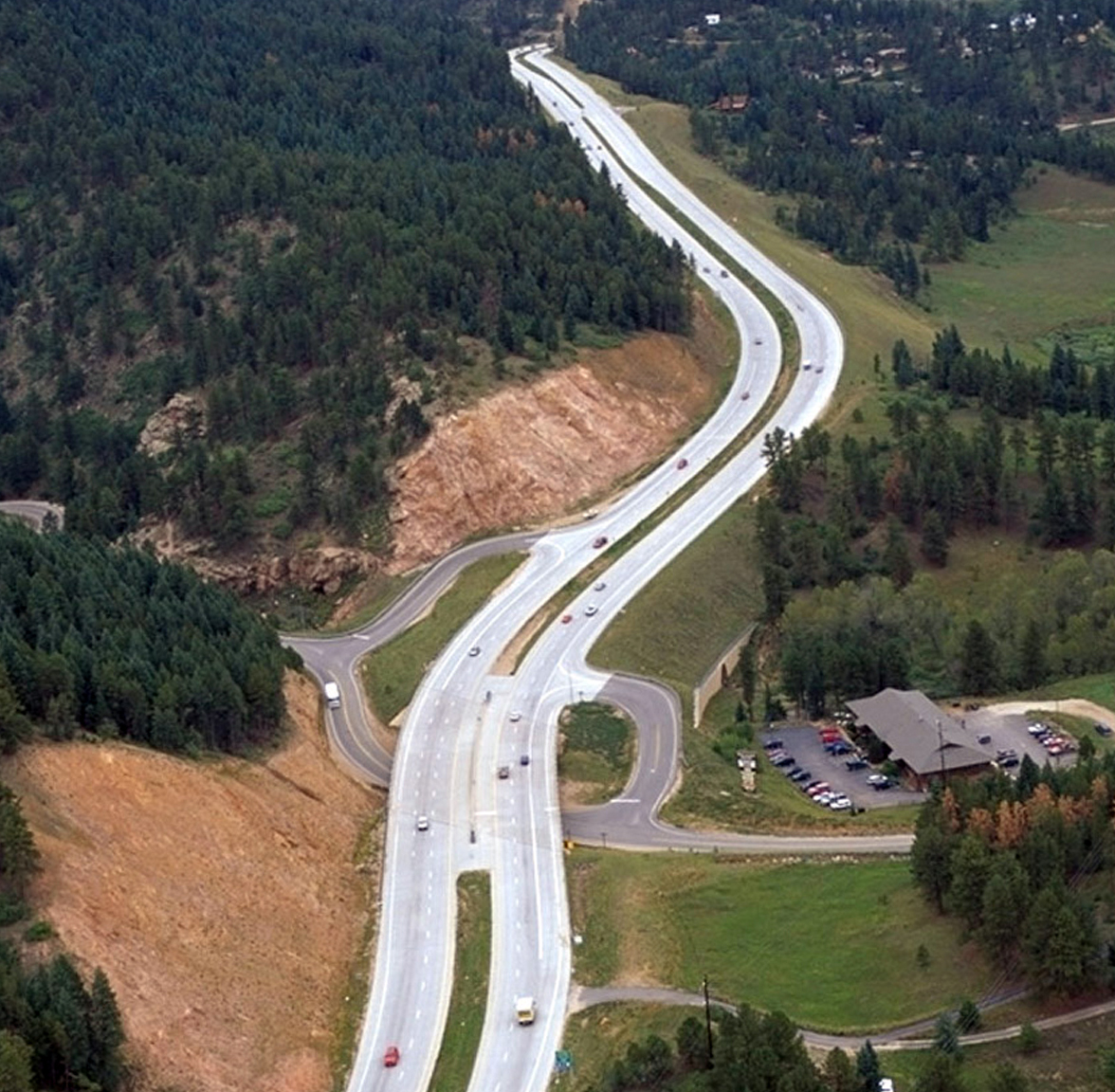
Source: Gaskill, Craig, 2007, Cost-Benefit Study of Applying Context Sensitive Solutions to US 285, West of Denver, Colorado. Transportation Research Board Annual Meeting, 2007. Paper #07-0098.
The NEPA study determined the permitting requirements of the project, including a NPDES storm water discharge permit from the Colorado Department of Public Health and Environment (CDPHE), Section 402 permit from CDPHE for dewatering of construction areas, Section 401 Water Quality certification from CDPHE, USACE 404 permit, Colorado Division of Wildlife Senate Bill 40 certification for stream crossings, FHWA Access Approval, Nest Take permit from USFWS, Fugitive Dust permit, State Access permit, Construction Access permits; Access permits from FHWA and CDOT for new grade separations, and Floodplain Development permit.
Permits still have not been obtained, but there is every reason to believe they will be approved swiftly.
The Director of EPA Region 8 NEPA Programs specifically recognized the US 285 project for its use of CSS to avoid and reduce environmental impacts, noting “outstanding work was done by CDOT and its consultants. This is a great example of how impacts can be minimized.” Similarly, the ACOE noted the “excellent job the participants have done in avoiding and minimizing impact to the aquatic ecosystem.” (Kullman 2006)
Lessons Learned
“I've never seen a project that went better anywhere, ever.”
The US 285 widening from Foxton Road to Bailey represents the convergence of a number of collaboration-based ideas in transportation planning, such as:
- Mergers of multiple regulatory processes;
- Continuity and minimization of time gaps in the planning and project development processes;
- Early commitment to environmental stewardship;
- Serious engagement of resource agencies and NGOs from the start;
- Willingness to gather large scale environmental information (such as the aerial photography) to support early, planning level consensus-building and decision making and avoid revisiting decisions later;
- In-field multi-agency meetings, solution seeking, and decision making;
- Small neighborhood and one-on-one meetings;
- CSS-VE integration; and
- Flexible design.
Most of these concepts are captured in the general theme of context sensitive solutions. In this case, context sensitivity appears to be based largely on informed alternatives resulting from resource knowledge and transparent decision making, with public input and direction. Implementation of these organizational concepts by an experienced and professional team of planners created a successful process for US 285. Specific success factors, innovations, and solutions are discussed below.
Success Factors
Proactive Management of Environment Resources
This project was largely about the management of environmental resources. One interviewee claimed, “There were no significant issues environmentally;” however, the project area is scenic, rural, and mountainous, a home to wildlife as well as people. The lack of environmental issues was the result of strategic design. The feasibility study, which produced early data on corridor resources, allowed for early involvement by agencies and a focused NEPA process. One participant noted, “When design accounts for resources from start you can really save time and effort.”
The conceptual designs reflected the early identification and mapping of resources, including eight properties that were either on or eligible for inclusion on the National Register of Historic Places; 44 wetland sites, including nine tributary drainages to the South Platte River; wildlife habitat; high scenic values including mountain views; existing open spaces areas; water quality concerns; and noise and air quality issues.18 Through collaborations in meetings, in the field, and in design, more than three acres of wetland impact was avoided, resulting in final wetland impacts of less than one acre. Alignment shifts and retaining walls were used to completely avoid all direct impact to six historic properties, thus eliminating the need for Section 4(f) analysis. The project team identified five locations for wildlife crossings, worked extensively to minimize visual impacts of the project, and were able to effect other beneficial environmental outcomes such as open space preservation, improved water quality treatment during construction and operation, and noise minimization.
Early Action to Address a Pressing Safety Issue
Because of the major accident issues identified at Richmond Hill, a “break out” project at this location was advanced out of the NEPA process and developed as a categorical exclusion (CE) to reduce the time to construction. The efficiency of the NEPA process allowed for this part of the improvement to get a head start. The Richmond Hill project broke ground in March 2006, and is now under way with a construction budget of $11 million.19 The bridge was designed to preserve views and frame surrounding vistas with an aesthetically pleasing bridge with slant leg piers. Extensive interaction with the fire and safety personnel resulted in cost-effective operation improvements in the firehouse area; relocating the access roadway allowed space for vehicle movements, while providing safe access to US 285.
Flexibility
In conducting interviews for this case study it was clear that flexibility was a major element of the process. In some cases this may simply have been a matter of attitude, with a perception of flexibility. The positive attitude and sense of flexibility led to heightened stakeholder trust and buy-in. As one participant noted, “The project also improved relationships with a community that has not traditionally held a very high opinion of the CDOT.” This is important because trust built in one project can lead to other partnerships and collaborations. Accolades included:
“CDOT Region 1 was open to environmental concerns more [on this project than other agencies have been on other projects]. They had a good consultant that did great outreach, and did good engineering job.”
“CDOT and Carter & Burgess really had a flexible perspective that accounted for environmental resources and public concerns.”
“The contractor Carter & Burgess had this guy who was truly awesome. He was willing to roll up his sleeves and talk to people, suggest design changes, but at the same time be sensitive to the resource context. He could really discuss the variables in a level headed way. Did a great job.”
“The only tradeoff was a willingness to listen to and consider ideas from the public and incorporate them into designs.”
Transparency and Commitment to Cooperation and Consensus Building
An element of the community trust was based on the interactions and transparency of decisions. “We saw engineers saying, ‘Well, we could do this…’ It was done very well.” All interviewees for this case study agreed that decisions were made clearly, they were transparent, and they were based on consensus. It is difficult to quantify this as an element of the project, but it certainly smoothed the process and left a lasting impression on all.
Context Sensitive Solutions
The factors above – environmental sensitivity, flexibility, and transparency and participation in decision making – were part of what made the US 285 project an example of CSS. The Director of EPA Region 8 NEPA Programs specifically recognized the US 285 project for its use of CSS to avoid and reduce environmental impacts, noting “outstanding work was done by CDOT and its consultants. This is a great example of how impacts can be minimized.” Similarly, the USACE noted the “excellent job the participants have done in avoiding and minimizing impact to the aquatic ecosystem.”20
Early and Consistent Communication
Early communication seems to be the central element of the successful CSS process. “It was just early communication. We did make some changes to the design… Mostly we kept residents informed so that they didn’t get surprised or get mad and think that you are shoving a design down their throat.” Early and ongoing communication has several effects, but one of the most important is minimizing drastic changes later.
In the words of one resource specialist, “My role is being overstated.” Early involvement, well before major design decisions, enables many resource issues to be worked out or around, minimizing impacts that might otherwise be significant. The multidisciplinary approach was especially effective in parts of the corridor that had wetland resources on one side of the road and historic properties on the other side. Agreements were reached between the USACE and the SHPO on these areas, facilitated by meetings in the field.21 “The mergers and ultimate CSS process was a definite beneficial trade-off. Time and money was saved in the NEPA process, significantly less environmental impact was achieved, [and]…CDOT got major points with the public and emerged with very favorable reputation.”
Value Engineering to Reduce Costs and Increase Value
One clear success of the project was value engineering to reduce costs and increase value. The CSS process resulted in a capacity improvement alternative that saved over $59 million, addressed the purpose and need for the project, reduced preparation and review time, and allowed an early action breakout project to proceed independently addressing a critical safety concern.22 Savings were the result of the various efficiencies and design solutions applied during the NEPA process. By downgrading the document from an EIS to an EA, the project saved at least eight months of time and approximately $500,000 in study costs. Cost savings may be summarized as follows:23
- Wetland mitigation savings: $200,000
- Downgrade of the EIS to an EA savings: $500,000
- Use of grade-separated intersections savings: $55 million
- Elimination of grade-separated intersection at Wisp Creek savings: $6 million
- Use of CDOT personnel: $200,000 in costs otherwise committed
Despite some of the stereotypes about value engineering, this exercise was not merely focused on cost reduction. Additional costs were incorporated to increase value, including:
- Use of wildlife underpasses additional cost: $2 million
- Additional culverts for small wildlife crossing: $100,000
- Additional aesthetic treatment at bridges: $250,000
Innovations and Solutions
The process was considered highly efficient by nearly all participants. Issues were so successfully addressed and resolved that interviewees generally could not answer questions about stumbling blocks, problems, or what might have worked better. No one mentioned tough decisions or problems with US 285, and even the word “issues” seemed a little strong for most circumstances. Early interaction with the public and with resource agencies prevented potential issues from developing down the line. This was a simple innovation of timing within the process. Most of the techniques and methodology were in fact quite typical, with a few exceptions.
Timing, Interaction, Collaboration, and a Creative VE-CSS Process
Elements of the US 285 project that might be considered innovative are mainly in the area of process, interaction, and collaboration. Decisions emerged from an open and transparent process and were sustained from the feasibility study through the NEPA and project development process. The creative use of VE and CSS for this project made the process more efficient.
Successful Downgrading of EIS to EA – Interim Assessment of NEPA Class of Action Determination
FHWA agreed to downgrade this project from an EIS to an EA, and several interviewees made comments related to the rigid nature of the environmental process and levels of documentation. “The biggest issue with the entire NEPA process is trying to align data collection to what really matters.” In this case the feasibility study went a long way towards doing just that. “At the start you assume the worst case scenario, which is the EIS.” FHWA’s flexibility in agreeing to change the level of documentation was a central turning point of this project.
One interviewee suggested that it might be effective to develop an interim assessment of the level of effort for NEPA. The idea was that “once you've identified what your best case solution is, an EIS can easily turn into an EA.” If there was a step included in the NEPA process for evaluating resources and design requirements, and reconsidering the NEPA class of action determination, unnecessary data gathering and expense might be avoided, especially since agencies often choose a higher level of documentation, when in doubt, to be on the safe side. CEQ advises against this tendency, as an EA is intended to discover whether significant impacts are in evidence. DOTs are increasingly exploring what can be accomplished and how environmental protections may be retained with lower class of action determinations, especially Categorical Exclusions, as discussed in NCHRP 25-25(13) and in the delegation provisions of SAFETEA-LU.
SHPO Involvement
Early SHPO involvement in the US 285 project was an unusual tactic of highway planning, especially in 2002. SAFETEA-LU now puts an emphasis on getting cultural resources integrated into the planning stages. Whereas earlier legislation suggested the approach, it is now a stronger directive. One interviewee expanded on the fact that Section 106 can be worked into NEPA much better than it has typically; “too often it is separated and isolated.” CDOT asked the SHPO to be a cooperating agency on this project, which had never occurred before. The offer was not formally accepted for the NEPA process, but as an overture to collaboration, it was apparently a prudent move. The SHPO was not kept in a purely regulatory role, but instead felt involved and empowered. “Lots of the money spent on historical sites, as well as the destruction of historic resources, could be avoided with more cooperation early on in the process,” such as occurred on US 285.
The extent to which SHPO collaboration can be extrapolated to other projects will vary. CDOT had in-house archaeological staff, and the SHPO specialist provided input mostly on architectural history. The project area was near the state capital, and was not extremely large. According to another interviewee, “this was a very small project, about an hour from Denver. I took part of a day and traveled to the project location to look around. It was definitely very helpful, but it’s impractical for most projects.” SHPOs are generally under funded and under staffed. They can afford neither the travel budget or employee time away. The corollary is that clever solutions for obtaining SHPO involvement would be highly desirable. They should be inexpensive, conducted early in the process, and would likely have to be worked out on a case by case basis. One suggestion was the use of video that showed the project area and nearby structures that might be impacted by construction.
Integrated Design Considerations
In terms of design, “they did a design-level ROW plan and mapping survey on the corridor – which we wouldn’t normally need for the NEPA process.” Level and timing of design were linked into the feasibility study. More time and money were spent on the feasibility study than normal; however, the information allowed for a more focused NEPA process. A number of wildlife crossings – five 12-foot high ones for large animals and numerous culvert-style ones for smaller animals – were built into the preliminary design right from the beginning. This allowed the engineers to factor these into the plans, rather than trying to retrofit them as an afterthought, without sufficient budget.
CDOT and the consultant invested a fair amount of analysis in the depressed median and shoulder widths. The road template – the cross-section with a depressed median and shoulder – drove width and curvature of road, as well as design speed. This is important because when drivers face sudden changes in the expected severity of the curves they encounter, accidents often result. A depressed median is safer, because it gives recovery room for errant drivers. Mountain highways tend to be less safe and the corridor had its own safety challenges, so this was important to the community. A depressed median also allows for turn lanes and safer movements, and the grassy median is a recovery area for animals trying to get across the highway. Environmental groups and CDOT biologists felt this was very important, but a depressed median results in a wider "footprint." Designers and engineers performed several iterations of horizontal and vertical alignments to get to a wider highway that would still fit within canyon-like portions with relatively few cuts and disturbances to waterways and properties. An 8-foot wide outside shoulder offered the best tradeoff for broken down vehicles. The community thought very highly of the "mini interchanges" with over or underpasses, plus right in/right out on either side of the freeway, so these solutions were retained. Such approaches take less space. They can also be snaked around problem areas, and still function quite well as long as traffic is not too high. A preliminary design was done for every interchange location, building these solutions in right from the start.
Need for Better Estimation Earlier in the Process
Funding is the biggest issue on many highway projects, and funding changes from year to year. Funding can impact every aspect of a highway project. Consequently, funding can be leveraged in selective ways by decision makers within a project. Safety is a significant premise for additional highway capacity, and when funding is tight, environmental considerations are relegated to a lower priority behind safety concerns. An example of this may be seen on the US 285 project. When costs needed to be cut after the NEPA process had been completed, the wildlife underpass at Shafer's Crossing was proposed for removal from the plans. As one participant explained, “it is easier to cut out costs driven by environmental issues because no one wants to cut safety features.” The cost cuts were made without realizing their significance to the planning and design arrangement. One interviewee said it made CDOT look like they had over-committed to the community, and could have seriously eroded CDOT’s credibility. The crossing feature was restored to the design plans and the project continued without this emerging as the problem it could have been. The issue highlights the complications inherent in carrying a project forward from one process (the NEPA review) to another (design refinement). With tight budgets the different interests on a project – designers, planners, environmental managers – can become competing interests. In the case of US 285 there was close agreement on issues and the underpass was put back into the design, but the episode highlights the need for better estimation and greater inclusion of all costs early in the process.
Funding remains unresolved for completion of the US 285 project. The DRCOG included $15 million for interim improvements on their section of roadway in 2004. Approximately $79 million was prioritized on the 2004 STIP for the project. “The US-285 project actually scored pretty weakly compared to more ‘urban’ projects, but because 285 was a statewide connector, and Region 1 was in relatively better financial shape, the project was included on the fiscally constrained RTP and TIP.” It is unclear if it is fully funded now. Mitigation plans are still being finalized and no 404 permit has yet been issued. Current cost estimates are $180 million, plus the $11 million “break out” project. As one interviewee put it, “the transportation system in Colorado is always playing catch-up.”
Conclusion
The process of involving agencies early in the US 285 project worked so well that some methods have now become standard procedure. CDOT has now implemented a statewide formal merger with USACE on the 404 process. The CDOT Environmental Stewardship document, which came out during the US 285 project, has ‘institutionalized’ concepts that were occasional ‘best-practices’ then. These types of changes aim to take positive examples and turn them into standard practice.
References
Carter & Burgess, Inc
2004 US 285 (Foxton Road to Bailey), Jefferson and Park Counties, Colorado, Environmental Assessment. Technical report prepared for the Colorado Department of Transportation Region 1 by Carter & Burgess, Inc., Denver Colorado, August, 2004.
2002 US 285 Foxton Road to Fairplay Feasibility Study. Technical report prepared for the Colorado Department of Transportation Region 1 by Carter & Burgess, Inc., Denver Colorado, March 2002.
CDOT
2007 Evaluation and Mitigation of Environmental Impacts Prior to Project Selection: US 24, MP 311.7 T0 MP 339.0, Results of an Assessment of the Corridor Approach for Early Evaluation of Environmental Resources. Report Number CDOT-2007-6. Environmental Programs Branch, Colorado Department of Transportation. Prepared in cooperation with the US Department of Transportation, Federal Highway Administration, April, 2007.
2006a Press Release: US 285 Environmental Study Honored with National Award. December 14, 2006.
2006b Annual Report.
FasTracks
2007 Transit Oriented Development. Regional Transportation District of Denver (RTD) Denver, Colorado. http://www.rtd-denver.com/
Federal Register
2007 Project. Volume 72, No. 92, Monday May 14, 2007, p. 27170.
2002 US 285 Notice of Intent. Volume 67, Number 134, pp. 46241-46242.
FHWA
2007 Public Roads, Volume 70, Number 6 (May/June). US Department of Transportation.
2002 Case Study – GARVEEs Southeast Corridor Project (T-Rex). In Innovative Finance Primer, April 2002. United States Department of Transportation - Federal Highway Administration. Available at: http://www.fhwa.dot.gov/innovativefinance/ifp/cssouth.htm
Gaskill, Craig
2007 Cost-Benefit Study of Applying Context Sensitive Solutions to US 285, West of Denver, Colorado. Transportation Research Board Annual Meeting, 2007. Paper #07-0098.
Kullman, Jeff
2006 Application: AASHTO Center for Environmental Excellence National Context Sensitive Solutions Competition.
TRANS Notes
2003 Transportation Revenue Anticipation Notes. A Fact Sheet of the Governor’s Office of State Planning and Budget. July 2003.
Endnotes
1 CDOT, 2006a, Press Release: US 285 Environmental Study Honored with National Award. December 14, 2006; FHWA, 2007, Public Roads, Volume 70, Number 6 (May/June). US Department of Transportation.
2 Carter & Burgess, Inc., US 285 Foxton Road to Fairplay Feasibility Study. Technical report prepared for the Colorado Department of Transportation Region 1 by Carter & Burgess, Inc., Denver Colorado, March 2002; Carter & Burgess, Inc., US 285 (Foxton Road to Bailey), Jefferson and Park Counties, Colorado, Environmental Assessment. Technical report prepared for the Colorado Department of Transportation Region 1 by Carter & Burgess, Inc., Denver Colorado, August, 2004.
3 Carter & Burgess, Inc., US 285 (Foxton Road to Bailey), Jefferson and Park Counties, Colorado, Environmental Assessment. Technical report prepared for the Colorado Department of Transportation Region 1 by Carter & Burgess, Inc., Denver Colorado, August, 2004.
4 Carter & Burgess, Inc., US 285 Foxton Road to Fairplay Feasibility Study. Technical report prepared for the Colorado Department of Transportation Region 1 by Carter & Burgess, Inc., Denver Colorado, March 2002.
5 Case Study – GARVEEs Southeast Corridor Project (T-Rex). In Innovative Finance Primer, April 2002. United States Department of Transportation - Federal Highway Administration. Available at: http://www.fhwa.dot.gov/innovativefinance/ifp/cssouth.htm.
6 Transportation Revenue Anticipation Notes. A Fact Sheet of the Governor’s Office of State Planning and Budget. July 2003.
7 FasTracks, 2007 Transit Oriented Development. Regional Transportation District of Denver (RTD) Denver, Colorado. http://www.rtd-denver.com/.
8 Kullman, Jeff. 2006, Application: AASHTO Center for Environmental Excellence National Context Sensitive Solutions Competition.
9 CDOT, 2006a, Press Release: US 285 Environmental Study Honored with National Award. December 14, 2006.
10 US 285 Foxton Road to Fairplay Feasibility Study. Technical report prepared for the Colorado Department of Transportation Region 1 by Carter & Burgess, Inc., Denver Colorado, March 2002.
11 Federal Register 2002, US 285 Notice of Intent. Volume 67, Number 134, pp. 46241-46242.
12 Federal Register, 2007, Project. Volume 72, No. 92, Monday May 14, 2007, p. 27170.
13 CDOT, Evaluation and Mitigation of Environmental Impacts Prior to Project Selection: US 24, MP 311.7 T0 MP 339.0, Results of an Assessment of the Corridor Approach for Early Evaluation of Environmental Resources. Report Number CDOT-2007-6. Environmental Programs Branch, Colorado Department of Transportation. Prepared in cooperation with the US Department of Transportation, Federal Highway Administration, April, 2007.
14 Gaskill, Craig, Cost-Benefit Study of Applying Context Sensitive Solutions to US 285, West of Denver, Colorado. Transportation Research Board Annual Meeting, 2007. Paper #07-0098.
15 Kullman, Jeff, 2006, Application: AASHTO Center for Environmental Excellence National Context Sensitive Solutions Competition.
16 Gaskill, Craig, Cost-Benefit Study of Applying Context Sensitive Solutions to US 285, West of Denver, Colorado. Transportation Research Board Annual Meeting, 2007. Paper #07-0098.
17 Kullman, Jeff, 2006, Application: AASHTO Center for Environmental Excellence National Context Sensitive Solutions Competition.
18 Ibid.
19 Ibid.
20 Ibid.
21 Gaskill, Craig, Cost-Benefit Study of Applying Context Sensitive Solutions to US 285, West of Denver, Colorado. Transportation Research Board Annual Meeting, 2007. Paper #07-0098.
22 Ibid.
23 Ibid.