
US Department of Transportation
FHWA PlanWorks: Better Planning, Better Projects
| Key Decisions | Framework Applications |
|---|---|
US 24 - New Haven, Indiana to Defiance, Ohio
9-Step Transportation Development Process
Executive Summary
In 1991, US 24 was identified as a “High Priority Corridor on the National Highway System” and, in Ohio, it was described as one of the corridors “of statewide significance upon which rests the economic vitality of Ohio.”
The United States Route 24 (US 24) project represents a long-standing commitment by the states of Ohio and Indiana to improve US 24 between Fort Wayne, Indiana and Toledo, Ohio. Studies on improvements to US 24 were initiated in the 1960s and continued off and on through the 1990s. Except in the major urban areas, the US 24 corridor between Fort Wayne and Toledo is a rural two-lane arterial roadway. It has narrow and discontinuous shoulders, and frequent access points for local roadway crossings. Nicknamed the “Fort to Port,” US 24 provides a crucial link in the transportation network for the movement of goods to and from the Port of Toledo. Over the years, US 24 experienced significant traffic growth, especially truck traffic that accounts for more than 40 percent of the traffic volumes. In 1991, the Intermodal Surface Transportation Act (ISTEA) identified US 24 as a “High Priority Corridor on the National Highway System” and in 1993, Access Ohio described it as one of the corridors “of statewide significance upon which rests the economic vitality of Ohio.” 1
The Ohio Department of Transportation (ODOT) and the Indiana Department of Transportation (INDOT) proposed to relocate approximately 41 miles of US 24 and expand it to a new four-lane, limited-access highway (freeway in Indiana and expressway in Ohio). This new roadway will run between New Haven and Defiance, one of three segments of US 24 slated for improvement. ODOT and INDOT initiated the Environmental Impact Statement (EIS) in January 1999 and concluded with a Record of Decision in December 2005. The selected alternative was a new alignment south of and parallel to the Maumee River and the existing US 24 roadway.
By agreement, ODOT was the lead agency for the NEPA process. The US 24 EIS was one of Ohio’s first projects to use the new “9-Step Transportation Development Process” (TDP). ODOT’s Office of Environmental Services developed the process to streamline the National Environmental Policy Act (NEPA) compliance using an interdisciplinary and systematic method for analyzing alternatives, potential impacts, and mitigation measures. The 9-Step TDP required a balanced consideration of transportation needs and environmental impacts, and was designed to improve public trust and confidence in ODOT.
Each of the nine steps in the TDP coincided with the key decision points and milestones to be completed for project development. The process required public involvement at six of the nine steps and resource agency concurrence at four steps. At each concurrence point, ODOT and INDOT conducted a series of three public meetings across the corridor followed by a two-week public comment period. Additionally, there were numerous other formal project meetings and informal meetings with individuals and local community organizations as needed to reach all stakeholders expressing an interest in the project. Agency and public comments resulted in many design refinements intended to avoid or minimize impacts to ecological resources and private property owners, and address additional transportation needs of farmers and the Amish community for access through the corridor.
In 1989, a grassroots consortium of citizens, businesses, trucking organizations, economic development planners, and other stakeholders across the corridor formed the Fort to Port Organization to raise awareness of congestion and safety issues. The Organization engaged local, state, and federal elected officials to eventually obtain federal funding to begin the EIS. The Organization was a significant driving force in the success of the project.
Three major factors complicated the completion of the EIS:
- The need for coordination between the two states with diverse procedures and protocols for conducting the project development process;
- State and federal resource agencies that had different representatives for Indiana and Ohio who didn’t always speak with the same voice making it more difficult to reach agreement and make decisions; and
- A high rate of staff turnover at INDOT and the resource agencies.
Nevertheless, the project management team’s commitment to keep the project moving, extensive and consistent outreach to the stakeholders throughout the process, and the team’s willingness to listen to and address public and agency concerns brought the project to fruition.
Background
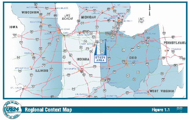
US 24 is a major east-west corridor through the mid-western United States, linking Michigan and Colorado. The eastern portion of the corridor passes through northern Indiana and northwestern Ohio, and is important because it provides the most direct access between Fort Wayne, Indiana and Toledo, Ohio, on Lake Erie. US 24 also provides a direct connection to Interstate 75 (I 75) and I-80/90 as well as the Great Lakes region, Canada, and other large cities along the eastern seaboard. Regionally, Fort Wayne is a major trucking hub and US 24 acts as a crucial link between suppliers and markets for the movement of goods and services to and from the Port of Toledo (Figure 1).
In 1994, the US Route 24 Improvement Feasibility Study identified three distinct segments of US 24 between New Haven and Toledo as independent planning sections:
- I-469 (New Haven) in Indiana to the bypass of Defiance, Ohio
- Bypass of Defiance to the bypass of Napoleon, Ohio
- Bypass of Napoleon to I-475 near Toledo
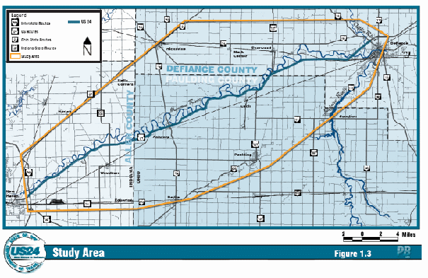
Each of these sections is a two-lane highway bounded on either end by a multi-lane, divided highway, and each section is a link between two major urban centers. The first section – New Haven, Indiana to Defiance, Ohio – is the subject of this study (Figure 2). The study area includes Allen County, Indiana and portions of Paulding and Defiance counties in Ohio.
|
Figure 1. Regional Context |
|
|
|
Source: US 24 New Haven to Defiance Draft Environmental Impact Statement |
Much of the existing US 24 between New Haven and Defiance is a two-lane arterial roadway winding along the Maumee River. The area is largely rural, consisting of rich and productive farmlands. Industrial, commercial, and residential developments also characterize the area and are concentrated along US 24 and its local cross streets. Historically part of the Great Black Swamp, much of the study area has been converted to agricultural land over the past century. The corridor contains remnants of small stands of forests and wetlands that provide habitat for the Indiana bat, a federally listed endangered species.
Project Overview
US 24 is being improved to address safety concerns and traffic congestion along the existing route and accommodate future economic growth in the region. The project will relocate approximately 41 miles of US 24 and expand it to a four-lane, limited-access freeway to improve traffic flow and safety. The highway will follow a new alignment from east of the I-469 Bypass in New Haven to State Route 424 west of Defiance. In Indiana, the road will be a freeway, and in Ohio it will be an expressway. Construction of the Ohio portion is expected to be completed by fall 2009 and Indiana expects to complete construction in 2011.
|
Figure 2. US 24 Study Area |
|
|
|
Source: US 24 New Haven to Defiance Draft Environmental Impact Statement |
Project Drivers
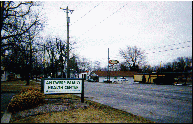
In the mid-1980s, citizens began raising concerns about the increasing number of accidents and fatalities along US 24. In the interconnected rural communities that line this corridor, fatalities are rarely anonymous; many knew people who had died traversing the route. Public awareness increased with traffic problems, as the rural two-lane road evolved into a major trucking route. By the late 1980s, the trucking industry also raised concerns about congestion and reduced mobility that hindered their ability to transport goods between Fort Wayne and Toledo. Increased growth and development along the route, frequent driveway cuts or access points for local residences and businesses, and other local roadway crossings contributed to increased travel times. The roadway has narrow, often discontinuous shoulders, and numerous no-passing zones (Figure 3). Nearly half of the overall traffic consists of trucks. The roadway’s geometric deficiencies frequently cause traffic to back up behind slow moving platoons of trucks, making passing hazardous.
In 1994, ODOT, INDOT and the Federal Highway Administration (FHWA) completed the US Route 24 Improvement Feasibility Study which analyzed the highway characteristics, traffic conditions and capacity, accident history and economic development influences of US 24 between the cities of New Haven and Toledo. Approximately 14 percent of the roadway consisted of four-lane divided highway; the remainder was two lanes. The study found that the
Figure 3. Narrow Roadway
|
|
|
Source: US 24 New Haven to Defiance Draft Environmental Impact Statement |
four-lane segments would provide adequate capacity over the next 25 years, but the two-lane segments were already operating less than optimally due to congestion. Increased demand associated with a growing population, high volumes of truck traffic, inadequate design standards, and uncontrolled cross traffic all led to congestion problems, safety hazards, and decreased mobility.
Impaired Mobility
US 24 experienced substantial traffic growth for several years, at a rate higher than normal for northwest Ohio and eastern Indiana. New development and industrial growth along the corridor attracted a growing population and work force. In addition, greater reliance on inter-modal transportation (via rail, water, and highway) affects accessibility to both regional and national railroad connections and the Port of Toledo. ODOT estimates the average daily traffic volumes will grow to 13,000 vehicles per day by 2028, putting the roadway at maximum capacity.
Truck Traffic
|
Figure 4. Truck Traffic |
|
|
|
Source: US 24 New Haven to Defiance Draft Environmental Impact Statement |
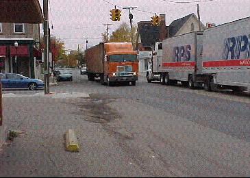
Truck traffic is the primary contributor to traffic congestion along US 24 (Figure 4). Between 1990 and 1997, truck volumes increased more than 128 percent in the corridor. In 1997, ODOT conducted an origin-destination survey that showed the majority of truck traffic was associated with long distance trips from Michigan and Toledo to points west. In 1998, truck traffic represented more than 40 percent of the total volume on US 24 and is expected to make up as much as 60 percent of the vehicle mix on some segments of the roadway by 2028, which could cause the traffic volumes to exceed the roadway’s capacity and result in severe congestion.
Reduced Travel Speeds
Normally, rural arterial roadways such as US 24 allow relatively high travel speeds. Between unincorporated areas, speed limits are generally 55 mph. Near populated areas traffic signals, uncontrolled access, truck traffic, school bus operations, active rail crossings, and inadequate shoulder widths for vehicle breakdowns reduce speeds to 25 mph. Speed limits on portions of US 24 have been reduced below 55 mph as truck volumes and development have increased.
Safety
US 24 does not meet today’s design standards. Shoulders are intermittent throughout the corridor. Where there are shoulders, they are a combination of pavement and gravel, and widths vary from 5 to 9 feet. This creates a hazard for stopped vehicles, emergency vehicles, police radar detection, and mail delivery trucks that need to pull off the roadway. The entire length of US 24 has uncontrolled access, including:
- Two active railroad crossings
- More than 50 commercial access points
- At least 67 at-grade cross streets, only five of which have signals
- Approximately 300 residential driveways
No-passing zones and school bus stops add to safety concerns. Accident data provided by the Ohio Department of Public Safety, INDOT, and the North East Regional Coordinating Council for the period from 1998 to 2000 showed that accident rates were lower than the statewide average but fatality rates were higher.
Economic Growth
US 24 is an essential link between the Port of Toledo and the interstate highway system. It is an important roadway for regional and national economic growth bringing farm and factory goods to market and facilitating local and regional business traffic. Locally, economic development agencies in both Ohio and Indiana recognize the importance of US 24 for access to and from large existing and planned industrial and commercial areas. Many companies in northwest Ohio depend heavily on US 24 for continued economic growth. On a larger scale, US 24 is identified as a “High Priority Corridor on the National Highway System” and is considered integral to the economic health of the Midwest.
Initial Concept and Planning
US 24 has been the subject of numerous planning and engineering studies beginning in the early 1960s when the Ohio Department of Highways Bureau of Location and Design, the forerunner of ODOT, first proposed a new 31-mile alignment between the towns of Maumee and Napoleon. Property owners opposed to the taking of their farmland for highway right-of-way defeated early plans for relocating the road. In the mid-1960s, the Ohio Department of Highways took another approach and planned a new four-lane alignment between Defiance and Napoleon. ODOT purchased the right-of-way and designed the roadway, but due to funding limitations, only two lanes were constructed.
For such an important link in the transportation network such as US 24, it was essential that capacity and safety be maintained at desirable rather than merely acceptable levels.
In the mid-1970s public opinion began to turn and as a result, improvements were made to a small segment of US 24 in the Toledo area. Funding limitations left needed improvements to other parts of the corridor unaddressed. In the 1980s, following a series of accidents near the Village of Waterville, a grassroots movement of local government, business, and citizen groups took up efforts to improve the roadway. With the help of the city engineer and ODOT, a citizens’ committee conducted another study of traffic congestion problems associated with US 24. When the study showed the problems were not limited to the Waterville area, the committee expanded the study to the neighboring communities.
At the same time, a group of citizens in the Fort Wayne/New Haven, Indiana area were becoming concerned about similar operational and safety problems. In 1989, an Indiana state representative called a meeting in Woodburn to address safety concerns. The representative invited Ohio legislators, local mayors, county commissioners, and other local elected officials; chambers of commerce; economic development organizations; regional planning organizations; and interested citizens to the meeting. The various citizen groups coalesced into the “Fort to Port Organization.” The group gained momentum, engaged other citizens, businesses, trucking organizations, economic development planners, and other stakeholders across the corridor and became a significant driving force to move the project forward.
The Organization maintained a high level of citizen involvement throughout the process, and succeeded in getting the support of local, state and federal elected officials. In 1991, the Intermodal Surface Transportation Efficiency Act of 1991 (ISTEA) identified US 24 as a High Priority Corridor on the National Highway System and targeted the roadway for strategic improvements. ISTEA provided federally earmarked funds to initiate the necessary studies, overcoming the barriers of landowner opposition and insufficient finances that barred capacity improvement projects for US 24 in the decades between 1960 and 1990. Through continuous public outreach, the Fort to Port Organization eased landowner opposition and helped spur revenue-raising strategies such as a gas tax. In 1993, in response to the federal legislation, ODOT completed a statewide transportation study and strategic plan, Access Ohio, that identified US 24 as one of the macro corridors “of statewide significance upon which rests the economic vitality of Ohio.” 2 Central to the goals of Access Ohio were economic advancement, transportation efficiency, and improvement of the quality of life for all Ohio’s citizens. Because there is no regional transportation planning agency, the US 24 project did not go through ODOT’s statewide long-range planning process, although the Toledo Metropolitan Area Council of Governments (MACOG) did eventually provide data for the traffic studies. As a result of earnest work in response to community support and legislation, INDOT, ODOT and FHWA published the 1994 US Route 24 Improvement Feasibility Study that recommended a four-lane divided highway to provide long-term capacity and safety improvements.
In compliance with NEPA, ODOT and INDOT completed the EIS between January 1999 and December 2005. Once again, funding shortfalls delayed the project, but in the spring of 2007 construction began in Ohio and in Indiana construction is set to begin in 2008.
Major Project Issues
In addition to the capacity, mobility, and safety issues, there were other environmental and social impact concerns. Issues included impacts to high quality wetlands and habitat for the federally endangered Indiana bat, conversion of prime farmland to highway right-of-way, and access for the Amish community traveling by horse and buggy or on foot.
Institutional Framework for Decision Making
For more than 30 years, the lack of funding prohibited the much needed capacity and safety improvements to the US 24 corridor. In 1991, an Ohio Congressman obtained federally earmarked funds to initiate the EIS. ODOT received the earmarked funds and was designated the lead agency though the US 24 project required the participation INDOT. At the federal level, the Ohio Division of the FHWA had final signatory authority. Largely, ODOT was the key decisionmaker; however, the agency consistently engaged the public, its Indiana counterpart, and other stakeholder agencies. Decisions at key points were made in strategic meetings with INDOT, ODOT, Indiana FHWA and Ohio FHWA project managers. As a group, they would discuss the issues and public input and decide how to move forward. Ultimately, FHWA had the responsibility for the final decision.
As recipient of the federal funds and the lead agency, ODOT funded and developed the US 24 EIS using their recently developed 9-Step TDP. INDOT’s role centered on coordination with ODOT for the 11-mile segment of US 24 in Indiana. The five cooperating agencies for the EIS: U.S. Army Corps of Engineers (USACE), U.S. Environmental Protection Agency (USEPA), U.S. Fish and Wildlife Service (USFWS), Ohio Department of Natural Resources (ODNR), and the Ohio Environmental Protection Agency (OEPA) provided review and input at four concurrence points in the 9-Step TDP. ODOT designed the process to accommodate input into a project’s development by any individual citizen, group of citizens, or agency and provide them the opportunity to participate in the decision-making process. By encouraging agency coordination and public involvement early in the project development process, ODOT believed the 9-Step TDP would ensure a balanced approach in making transportation decisions, assist in defining policy options and investment strategies, and cultivate public trust and confidence.
Because the project crosses state lines, it required coordination with and approvals from two representatives for each resource agency; one from each state. For example, at the federal level FHWA, USFWS, and U.S. Department of Agriculture Natural Resources Conservation Service had separate state representatives. At the state level, resource agencies managed historic preservation and natural resources differently in each state. Often times the agencies interpreted or implemented the regulations differently and thus did not speak with one voice, making it more difficult to reach decisions. Differences between the states included such things as the format of public meetings, level of design detail during the NEPA process, and the ratio of wetland mitigation required by the USACE. The problems were compounded by a high rate of staff turnover at INDOT and the resource agencies. However, the ODOT Central Office environmental staff had good working relationships with the agencies and that, in conjunction with numerous one-on-one meetings and field reviews with the agencies, kept the project moving.
Stakeholder Involvement
In addition to the resource agencies, the Fort to Port Organization had a key role in shaping the US 24 project. The Organization developed as an advocacy group to keep people informed and became a champion for the project. The group ultimately consisted of 75 to 100 volunteers from unions, trucking companies, chambers of commerce, economic development organizations, and local citizens. Two active, influential individuals co-chaired the Organization: one worked for the Henry County Chamber of Commerce in economic development and the other was a council member in Waterville. Under their leadership the Organization used churches, schools, and city buildings to conduct ongoing meetings to bring US 24 to the attention of their legislators and the Ohio and Indiana Departments of Transportation. They also sponsored dinners for local, state, and federal elected officials and kept pressure on their representatives to focus attention on the need for the project. Their continued involvement with state and federal elected officials resulted in the inclusion of the project in ISTEA.
The Organization held a unique position that became a key to the success of this project. From the beginning, they invited ODOT to attend their meetings and built the foundation of a good working relationship to ensure that as the project progressed they were able to work as partners. At the same time, Organization members were concurrently friends and neighbors with the citizens of the rural communities involved, suffered the same sense of loss when a fatal accident occurred and understood the difficulties farmers had delivering their products on time. Other stakeholders viewed the Organization as a neutral party rather than “big government,” which instilled a level of trust between the citizens and the Organization. The Organization encouraged citizens to participate in the public meetings and garnered the support needed to overcome some of the initial opposition to the project by organizations such as the Sierra Club and Family/Farming Americans Resisting More Unneeded Pavement (FARMUP).
Transportation Decision-making Process / Key Decisions
ODOT used their 9-Step TDP to complete the US 24 EIS. ODOT’s Office of Environmental Services developed the process to address some of the historic challenges in complying with NEPA, including the need to conduct multiple studies, interagency coordination, and public involvement. The guidance provided a systematic framework for making decisions when preparing Environmental Assessments (EAs) and EISs. ODOT designed the TDP to ensure uniform standards and compliance with all legal requirements in addition to accommodating agency coordination and public involvement throughout the NEPA process. Detailed guidance, tasks to be completed, products produced, and timelines for each step are included in The 9-Step Transportation Development Process for Environmental Assessments & Environmental Impact Statements manual. Figure 5 represents the structure of the TDP.
Each of the nine steps in the process served as a milestone in the decision-making process with resource agency concurrence at four of the steps. At each concurrence point ODOT and INDOT held a series of three public meetings across the corridor followed by a two-week comment period to solicit “formal” stakeholder input. The comment period enabled resource agencies and the public to provide input on the purpose and need statement, the range of reasonable alternatives to evaluate in the Draft EIS, identification of the Preferred Alternative [Draft EIS], and selection of the Preferred Alternative [Final EIS]. The US 24 project was one of the first projects to go through the 9-Step process and closely followed the decision-making process described below.
Step 1 – Planning and Programming
“Step 1 initiates the transportation development process. Planning and Programming includes identifying the need for a project and its funding, and incorporating the project into the State Transportation Improvement Program.”3
The segment of US 24 that is the subject of this study is not within a metropolitan planning organization (MPO) area. Typically ODOT is responsible for the planning process, in cooperation with local government officials, for areas outside of MPO areas. After ISTEA identified US 24 as a High Priority Corridor, ODOT completed a statewide transportation study and strategic plan, Access Ohio, in 1993. The study identified the US 24 corridor as a “macro corridor” defined as one of “those corridors of statewide significance upon which rests the economic vitality of Ohio.” 4 In 1994, the United States Route 24 Improvement Feasibility Study and other traffic studies were completed and subsequently provided the basis for the purpose and need statement in the EIS.
Figure 5. The 9-Step Transportation Development Process
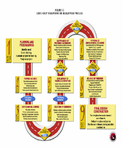
Source: US 24 New Haven to Defiance Draft Environmental Impact Statement
Slightly out of sequence with the 9-Step TDP, the study area and logical termini were identified in the Feasibility Study. In accordance with FHWA regulations, the study determined that US 24 between Fort Wayne, Indiana and Toledo, Ohio had three smaller, independently functioning segments. Each segment consisted of a two-lane section bound on both ends by an already completed four-lane, divided highway. Having identified logical termini, ODOT and INDOT determined the 500 square mile study area was large enough to consider a wide range of alternatives.
The US 24 corridor falls outside of an MPO area but the Toledo MACOG worked with the Fort to Port Organization, attended meetings, and served outside its area of jurisdiction by conducting some of the early traffic studies. The Toledo MACOG went to Waterville, Defiance, and Antwerp to address a regional need they saw as also affecting the Toledo metropolitan area. Toledo MACOG understood that a new highway only in the area of their jurisdiction would fall short of addressing the important congestion and safety issues experienced on US 24. Despite the challenges presented by looking at the corridor as a whole, they pursued a regional view and the larger potential benefits. For example, Toledo MACOG assisted Waterville in forming a larger regional group to study the US 24 corridor from Toledo to Defiance.
ODOT completed a modal analysis, an origin-destination study, a license plate survey, and a capacity analysis because a travel demand model was cost prohibitive, and they decided to forgo a Major Investment Study because it was not necessary for a rural corridor.
Step 2 - Purpose and Need Statement
“At Step 2, the purpose and need statement is documented, logical termini are determined, the study area is defined, and the public involvement plan is developed.”5
Draft Purpose and Need Statement
In January 1999, ODOT prepared a purpose and need study to examine existing and projected traffic volumes, traffic patterns, accident rates, and economic growth in the study area. ODOT used the results of the study to draft the purpose and need statement. After more than 30 years of studies, the purpose and need for improvements to US 24 were clear and straightforward. The US 24 project would improve the overall safety, provide additional capacity for increasing traffic volumes, and accommodate future economic growth. As lead agency, ODOT developed the purpose and need statement, INDOT reviewed it, and with few changes, FHWA refined and approved the statement for the Draft EIS.
Level-one Screening and Fatal-flaw Analysis
Over the next six months ODOT completed two additional studies. The first study, a modal analysis, evaluated the three planning sections as one unit to identify and investigate all feasible alternatives. The analysis evaluated various transportation alternatives such as transit, freight to rail, transportation system management, transportation demand management, alternative roadway options, and combinations of alternative strategies. The modal analysis also evaluated how well the alternatives addressed the purpose and need. The study concluded the various alternative strategies were either not feasible, not cost effective, or did not meet the purpose and need for the project. Only highway alternatives were found to meet purpose and need.
The second study included an environmental inventory for the 500-square mile study area. State and federal resource agencies were contacted for information pertaining to threatened and endangered species, wetlands, streams, historic sites, archaeological sites, and hazardous materials sites. Local agencies were contacted for information relating to planned development and the location of community resources such as churches, schools, hospitals and parks. ODOT created a map of the study area showing the information collected from the environmental inventory. In developing 14 preliminary 2,000-foot wide corridors, engineers used the map to avoid as many of the environmental features as possible and use existing transportation corridors where feasible.
Level-two Screening
ODOT conducted a broad-brush comparative analysis on the 14 preliminary corridors to assess the environmental impacts, to screen the preliminary corridors, and to identify feasible corridors for further study in Step 4 of the TDP. The environmental features and community resources within the study area were incorporated into a geographic information system (GIS) database for alternatives analysis. Based on the relative number of occurrences or acres of a given resource in the study area, ODOT assigned a rating of high, medium, or low for each resource category for the 14 corridors. Zero or equivalent values were removed from the analysis. The qualitative comparisons were given equal weight and did not reflect the individual qualitative significance. A comparative analysis matrix showing the total rankings (high, medium, low and none) for each corridor was presented at the public meetings (Figure 6).
Figure 6. Comparative Analysis Matrix
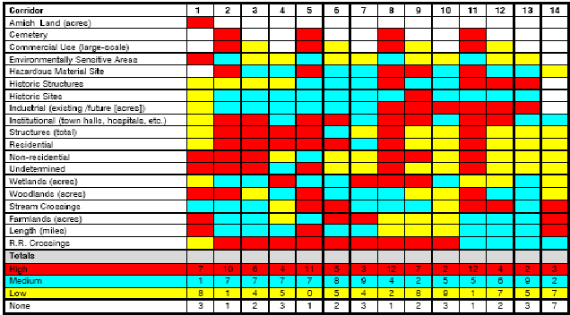
Source: US 24 New Haven to Defiance Draft Environmental Impact Statement
Public Involvement Program
-
The public involvement program (PIP) developed for the US 24 EIS was designed to allow all interested parties to participate in the project, and encouraged an open exchange of ideas and views. The PIP incorporated the following goals:
- Educate the public regarding the study process
- Keep the public informed of project activities
- Address all public issues
- Present the results of all study tasks to the stakeholders before making decisions
- Receive feedback from the public and government agencies
The PIP kept the public informed of the project status and provided opportunities for comments and input. The program included a stakeholder mailing list, project website, toll free hotline, and newsletters. Numerous formal project meetings as well as informal meetings were held with individuals and local community organizations, as needed, to reach all stakeholders expressing an interest in the project. For instance, ODOT held a neighborhood meeting in Defiance to talk about the neighborhood’s concerns about noise and possible mitigation.
For each concurrence point, ODOT convened three public meetings at central locations across the corridor; one in Indiana and two in Ohio. ODOT started each meeting with a history of accomplishments and stated the project expectations for the meeting. The project manager presented the information and then meetings were opened up to question and answer sessions. On some occasions, ODOT set up displays in an open-house format. ODOT preferred to do general question and answer sessions so everyone would hear the same questions and answers. In Indiana, an INDOT public involvement officer from Indianapolis ran the public meetings. An ODOT contractor facilitated the presentation and then INDOT took comments from the public.
Step 3 – Environmental Scoping
“Step 3 of the process includes the following: filing notice of intent, environmental scoping, mapping of environmental resources, identification of preliminary corridor, and agency coordination.”6
Concurrence Point #1 – Scoping
In June 1999, ODOT held three public meetings for Concurrence Point #1 in an open house format. The meetings were intended to inform the public about the purpose and need of the study, the modal analysis, and the environmental inventory. Additionally, the 14 preliminary corridors developed for the US 24 project were presented and the public was invited to provide comments. Across the corridor, meetings were well attended with approximately 500 people participating in the scoping process. A two-week public comment period followed the meetings. INDOT and ODOT did not have a formal process for documentation of agency concurrence.
In general, respondents supported making improvements to US 24 and many thought the improvements were long overdue. Most saw the project as a means to stimulate local economies, decrease congestion, and improve safety along US 24. The public favored 3 of the 14 preliminary corridors because they were considered to be a more direct route. Issues included farmland impacts, economic impacts, relocations, and emergency vehicle access. The public also suggested that truck bypasses be completed around small towns before constructing other sections.
Step 4 – Selection of Corridors
“During this step, the focus is on considering the results of the public involvement activities and input from the resource agencies. Field studies are also initiated at this step for the development and evaluation of feasible alternatives in Step 5.”7
Level-three Screening
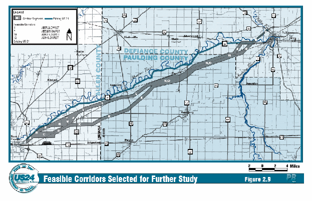
Following the public meetings and based on the process of elimination, the project team narrowed the initial list of 14 preliminary corridors and selected two corridors to advance for further study. Corridors and segments of corridors that were least favored by the majority of the public, had a high number of environmental impacts, or were inconsistent with local and regional planning, were eliminated from further study. In response to public comments, ODOT and INDOT added one new corridor and comments from the resource agencies resulted in two additional alternatives. A total of five corridors were selected for further evaluation in the Draft EIS. The resource agencies that provided input included USFWS, USEPA, ODNR, and the Indiana Department of Environmental Management. In general, the agencies agreed with the project’s purpose and need. Other agency comments included requests there be no new crossings of the Maumee River and that environmental impacts be kept to a minimum.
In the fall of 1999, ODOT and INDOT held public meetings to inform the public of the Feasible Alternatives to be evaluated further in the Draft EIS. More than 800 people attended the two meetings and a two-week public comment period followed the meetings. Comments received expressed concerns about a new alignment, quality of life issues, farmland impacts, and impacts to local roads.
Environmental fieldwork for the feasible corridors began in July 1999 and continued through the fall of that year. As part of the fieldwork, teams of biologists, historians and environmental scientists qualitatively and quantitatively identified the characteristics of natural and man-made resources within the five feasible corridors and mapped the results. ODOT used the results of these studies in the selection of the Preferred Alternative in Step 6.
Special public meetings for the US 24 project were held in February 2000 in Woodburn, Indiana and Defiance, Ohio to present the changes that occurred to the feasible corridors as a result of agency coordination for Concurrence Point #1 and an overview of the project activities that took place throughout 1999. More than 500 people attended the meetings and again, comments were consistent with previous public comments. The primary issues of concern were roadway safety, farmlands, residential displacements and economic development.
Step 5 – Development of Feasible Alternatives
“Step 5 tasks include preliminary engineering, determining environmental impacts, updating the Notice of Intent, and preparing an “Environmental Assessment of Feasible Alternatives” (EAFA) which is written in the format of a draft EIS8.”
Using the information collected from the environmental studies, project engineers divided the five corridors into an assortment of 26 individual segments. ODOT identified five Feasible Alternatives that included modifying the existing two-lane roadway within the US 24 corridor; a four-lane, controlled-access expressway along the existing US 24 corridor; a four-lane, controlled access expressway; and a mix-and-match of the 26 segments on new alignments (Figure 7).
In July 2000, ODOT and INDOT held another series of public meetings presenting the 26 segment alternatives and their environmental impacts. Approximately 800 people attended the three meetings. Citizens reviewed detailed information about the Feasible Alternatives including cost estimates, right-of-way requirements, environmental impacts, and interchange and intersection locations. Public comments identified preferred alternatives or segments and, consistent with previous comments, addressed concerns such as loss of farmlands, safety, and economic development.
Screening of Feasible Alternatives
At this point, ODOT went through a second series of screening steps for the feasible alternatives. The 26 Feasible Alternatives were further analyzed in a three-step screening process leading to the selection of the Preferred Alternative.
Step I – The 26 Feasible Alternatives were analyzed to determine if they met the established purpose and need of the project based on a quantitative analysis the following design criteria:
Figure 7. Alternatives Advanced for Study in the Draft EIS
Source: US 24 New Haven to Defiance Draft Environmental Impact Statement
- Improvements to traffic flow and level of service;
- Reduction in travel times between project termini;
- Improvements to roadway safety;
- Enhancement of the regional transportation network; and
- Ability to accommodate future economic growth in the region to enhance the competitiveness of local and regional businesses.
-
Of the alternatives evaluated in this first step, one alternative and the “No-Build” alternative (not included in the list of feasible alternatives) did not meet the purpose and need for the project and were eliminated from further consideration.
Step II – In the second step of the screening analysis, ODOT assessed the potential environmental impacts for the remaining 25 Feasible Alternatives. The analysis focused on environmental resources unique to the study area and those that required federal or state permits, if affected. The following resources were evaluated quantitatively and considered to be of equal significance in the analysis:
- Farmlands – total area of productive farmland impacted, number of landlocked parcels, total area of farmland landlocked, number of agricultural districts affected, number of farm operators affected, and number of farm residences displaced;
- Woodlots – number of woodlots affected and total area of woodlots;
- Category 3 (high quality) Wetlands – total area affected;
- Streams – number of stream crossings and total linear feet of streams impacted; and
- Displacements – number of residences and businesses displaced.
Impacts were separated into two categories relative to the median value of the dataset: values equal to or less than the median, and values greater than the median. Alternatives with 7 or more of the 13 measured parameters greater than the median value were eliminated from further consideration. Generally, alignments that had high ecological impacts had low social impacts, and those that had high social impacts had low ecological impacts. Step II eliminated 10 of the 25 remaining Feasible Alternatives.
ODOT did not use performance measures; instead they looked at the numbers and avoided using empirical data. Because no one alternative seemed ideal, ODOT divided the corridor into 10-mile segments and considered stakeholder comments for each region.
Step III – The third step of the analysis involved a more detailed examination of the environmental impacts and consideration of other information such as public and agency comments and right-of-way/constructability issues. This step focused the analysis on the five differentiating factors from Step II (farmlands, woodlots, Category 3 forested wetlands, streams, and displacements) as well as floodplain encroachments. As in Step II, median values were determined and the range of impacts were separated into two categories; values equal to or less than the median and values greater than the median. Two alternatives had a value greater than the median.
Comments from citizens, public officials, and resource agencies concerning the location of the Feasible Alternatives and certain alternative segments were also evaluated in Step III. Additionally, right-of-way and constructability issues were examined for phased construction aspects, impacts to local traffic patterns, and drainage of highway runoff.
Concurrence Point #2 – Recommendations for the Preferred Alternative
ODOT conducted agency coordination for Concurrence Point #1 and Concurrence Point #2 simultaneously. In January 2001, state and federal resource agencies received the Draft EIS for their review and identification of their Preferred Alternative. In March 2001, as part of Concurrence Point #2, ODOT convened a coordination meeting with the resource agencies to discuss the preliminary Draft EIS and Preferred Alternative recommendations. In attendance were representatives from USEPA, OEPA, FHWA and ODOT. The resource agencies focused their comments on impacts to Category 3 wetlands and streams. Both USEPA and OEPA recommended Alternative C as the Preferred Alternative because it had the least amount of impacts to wetlands. Other resource agencies providing comments indicated a preference for those alternatives that minimized impacts to wetlands, streams, farmlands, wildlife habitat, woodlands, and the Maumee River. Based on the examination of environmental impacts, public and agency comments, and review of right-of-way and constructability issues, in April 2001, ODOT identified Alternative C as the Preferred Alternative.
ODOT presented the Preferred Alternative to the USACE and OEPA during a field review in May 2001, focusing on potential impacts to Category 3 wetlands. During the agency field review, OEPA recommended Alternative D as the Preferred Alternative to avoid impacts to a particular high quality, forested wetland. As a result, detailed environmental studies were conducted for both Alternatives C and D. ODOT developed additional engineering designs with the intention of minimizing impacts to Category 3 wetlands. This resulted in the development of a 27th alternative, Alternative D-1. Overall, wetland impacts were less with Alternative C but Alternative D-1 resulted in fewer impacts to Category 3 wetlands. Subsequently, USACE identified Alternative D-1 as the least damaging practicable alternative and recommended it as the Preferred Alternative.
Concurrence Point #3
Based on the 9-Step process, Concurrence Point #3 would typically occur following Step 6. However, in May 2002, based on public comments, the agency field review, wetland delineation survey findings, and USACE and OEPA concurrence, ODOT and INDOT identified Alternative D-1 as the Preferred Alternative in Step 5.
Special Outreach Meetings
Between 1999 and 2003, ODOT and INDOT held a series of special outreach meetings with citizens, public officials, and special interest groups such as mayors, county commissioners, and county engineers; school system representatives; the Amish community; individual property owners; Sierra Club, and FARMUP. In general, ODOT and INDOT provided updates on the project and answered questions from individuals with specific concerns. Comments from these meetings were taken into consideration in the development of the Draft EIS and resulted in a number of design modifications.
In response to public comments, ODOT made design changes addressing concerns about connectivity from one side of US 24 to the other. Stakeholders viewed a railroad splitting the study area as a traffic impediment, and they wanted to avoid creating additional barriers in the communities and the study area. In response to connectivity concerns, ODOT decided to scale back the project from a freeway to an expressway thereby providing more at-grade intersections. ODOT used the existing railroad corridor or paralleled the existing railroad to prevent US 24 from further dividing farms and communities. ODOT designed the alignment to follow property lines or the edges of fields wherever possible to minimize impacts to farmland and individual property owners.
Step 6 – Identification of the Preferred Alternative
“During this step the Preferred Alternative is identified and the draft EIS is prepared. Tasks at Step 6 include preparation of Section 404 and 401 permit applications.”9
In June 2002, ODOT held a series of three public meetings to present revisions to the Preferred Alternative. Property owners were able to see how the preferred alternative specifically impacted their property, including the amount of acreage needed from each parcel for highway right-of-way. Approximately 500 people attended the meetings. During the two-week comment period ODOT received comments concerning site-specific impacts, the construction schedule, Amish transportation needs, interchanges, alignment location, and farmlands.
Design Refinements for the Preferred Alternative
After ODOT and INDOT identified the Preferred Alternative and following the June 2002 public meetings, design refinements focused on:
- Accommodation of the transportation needs of the Amish population - several grade-separated crossings designed to allow Amish vehicles to safely cross the new highway;
- Accommodation of transportation needs of farm operators - locate the roadway along property boundaries minimizing impacts to the extent feasible;
- Addition of service roads for landlocked properties;
- Design refinements to interchanges, intersections, and the median design; and
- Further minimization of wetland impacts.
The design refinements focused on identifying mitigation strategies to avoid or minimize impacts to sensitive resources.
During this period, Phase I and Phase II archaeological surveys were completed and the results submitted to the Ohio Historic Preservation Office and the Indiana Department of Natural Resources. The findings were presented to the Section 106 consulting parties and they agreed with the conclusions.
Step 7 – Approval of Environmental Document
“During Step 7, the environmental documentation is circulated for agency and public reviews, and public hearings are held to gather comments. The EIS is revised to address comments received on the Draft EIS. A Final EIS is prepared and made available for public review.”10
ODOT, INDOT and FHWA approved the Draft EIS on August 19, 2003 and the Notice of Availability was published in the Federal Register on October 3, 2003 initiating a 45-day public comment period. The Draft EIS was made available to the public, and state and federal agencies for review and comment. ODOT also made the Draft EIS available on the US 24 project website and paper copies were made available at 29 local agencies and organizations.
Three public hearings for the US 24 project were held in late October 2003. The public hearings provided an opportunity for citizens to “officially” comment on the project and the Preferred Alternative. Approximately 115 comments were received from citizens on a variety of project issues. Comments were also received from nine state and federal agencies. As a result, agency coordination continued and additional studies were conducted for streams and wetlands, scenic rivers, threatened and endangered species, cultural resources, and Section 4(f) resources.
Wetlands
Following field reviews, OEPA and USACE issued jurisdictional determinations for streams and wetlands in the Ohio portion of the corridor. ODOT prepared and submitted a Section 404 permit application, a Section 401 water quality certification application, and an isolated wetland permit application in June 2005. In response to agency comments, ODOT made several engineering design refinements to the proposed alignment to minimize potential impacts to high quality forested wetlands and the federally endangered Indiana bat. Wetland mitigation commitments included the purchase of 159 acres – 26 acres for the creation of compensatory wetland and a 133-acre woodlot for preservation of high quality wetlands.
Jurisdictional determinations for streams and wetlands in Indiana were deferred to the project development design phase as were the respective permit applications.
Scenic River
ODOT continued to coordinate with ODNR regarding effects to the Maumee River which is considered a State Scenic and Recreational River and a State Resource Water in Ohio. Following a field review to discuss the proposed design and construction of a new bridge crossing the Maumee River, ODOT analyzed several bridge alternatives. Though it was contrary to their policy, ODNR decided to allow ODOT to pursue their preferred design after taking into consideration cost, size of the structure, and inevitable impacts to the stream regardless of the structure built.
Threatened and Endangered Species
In their comments on the Draft EIS, USFWS requested additional information on the project impacts to the Indiana bat, a federally listed endangered species. ODOT documented potential project impacts to the Indiana bat in a biological assessment and initiated a Section 7 consultation in May 2005. ODOT and USFWS representatives conducted a field review in August 2005. Data collected during the field review were used to develop the biological opinion. ODOT made a number of commitments to USFWS to minimize the incidental take of Indiana bats including monitoring, education programs, restoration of habitat, and the incorporation of measures to benefit the bat in mitigation plans for streams and wetlands. Re-vegetation of wooded wetlands with native tree species and preservation of high quality wetland habitat had a dual purpose: it satisfied requirements for wetland mitigation and helped protect Indiana bat habitat.
Cultural Resources
ODOT conducted additional Phase I historic architecture and archaeological surveys. Survey results were documented in technical reports submitted for review and concurrence to the Indiana Division of Historic Preservation and Archaeology and the Ohio Historic Preservation Office. Resources of concern were located in the Indiana portion of the corridor. Indiana FHWA and INDOT prepared a Section 106 programmatic agreement stipulating actions FHWA and INDOT would take to satisfy FHWA’s Section 106 responsibilities. Stipulated actions included completion of appropriate archaeological investigations, efforts to avoid and minimize impacts, and mitigation plans.
Section 4(f) Resources
After additional coordination, FHWA and ODNR they determined that Section 4(f) did not apply to the project.
Refinements to the Preferred Alternative
Following the public hearings, ODOT and INDOT continued to make refinements to the Preferred Alternative. ODOT initiated Stage One engineering designs including drainage design, preliminary roadway design, and conceptual right-of-way limits. INDOT developed the proposed highway to a preliminary engineering level of detail.
Final Environmental Impact Statement and Concurrence Point #4
ODOT and INDOT completed the Final EIS for the US 24 project in October 2005. The Federal Highway Administration, Indiana Department of Transportation, and Ohio Department of Transportation approved the Final EIS on October 26, 2005. They made the Final EIS available for public review and comment in November 2005 with a 30-day comment period.
Step – 8 Issuance of Record of Decision
“During this step, remaining issues are addressed, Section 404 and Section 401 permit application and mitigation plans are completed, and the official acceptance of the proposed action is documented in the record of decision issued by FHWA.”11
The Federal Highway Administration issued the Record of Decision (ROD) for the US 24 project on December 9, 2005. The Selected Alternative, Alternative D-1, was same as the Preferred Alternative in the Final EIS. Two agencies provided minor comments which were addressed in the ROD. The ROD also identified the mitigation commitments for those impacts that could not be avoided.
Specific permits required for this project included Section 404 permits and Section 401 permits which were permitted separately for Indiana and Ohio. OEPA also required an isolated wetland permit. USFWS required an incidental take permit for the Indiana bat.
Step 9 – Final Design/Construction
“Step 9 is the final design and construction of the project, and implementation of the environmental commitments.”12
The Preferred Alternative is currently being implemented in several sections. There are three construction sections in Ohio and five construction sections in Indiana. Ohio began construction in spring 2007. Indiana is currently amending the Final EIS to evaluate proposed changes to interchanges and impacts to the Amish community.
Lessons Learned
ODOT’s 9-Step TDP included a systematic decision-making framework to meet the following goals:
- Early integration of planning, environmental and engineering activities
- On-going communication with agencies and the public
- Operational flexibility to handle special project needs
- Ability to adapt the scope to solve unforeseen problems
- Continual integration of analytical data
- Consideration of the needs and dynamics of an interdisciplinary team
The US 24 project closely followed the 9-Step process with a few exceptions and the project largely met these goals. Nevertheless, completion of the EIS took approximately one and one-half years longer than envisioned by the 9-Step process. The USFWS requested a biological assessment of the endangered Indiana bat late in the NEPA process that added about one year to the schedule but also resulted in an alternative that had fewer impacts to high quality wetlands and endangered species.
The project management team emphasized public involvement and listening to stakeholder concerns and were necessarily flexible while continuing to operate within the bounds of the process. They were open to new ideas and willing to undertake new procedures. ODOT made numerous design refinements based on public comments. The project management team successfully negotiated the decision-making process using the key factors presented below.
Success Factors
Benefits of a Strong Local Advocacy Organization
The determined efforts of the Fort to Port Organization forced legislators to obtain the necessary funding for the US 24 project. Though it took many years to become a reality, the stakeholders were committed to seeing the project through to completion. Two local leaders who lived in the project area co-chaired the Organization. They understood the transportation issues, local concerns, and the need for economic development. The Organization helped keep citizens and elected officials involved, and built strong relationships with ODOT. The broad-based coalition of support helped bring the project to fruition. As the construction process moves forward, the Fort to Port Organization is still active and ODOT invites them to participate in groundbreaking ceremonies.
Up-front Stakeholder Involvement and Collaboration to Save Time and Reduce Costs
The 9-Step TDP emphasized early and continued collaboration with the public and ODOT’s robust public involvement program was another key to the project’s success. ODOT engaged a wide range of interested stakeholders representing very different interests in the process. ODOT identified issues early, and addressed them as they were raised rather than waiting until the end of the process when it can be more difficult and costly. For example, ODOT reached early resolution of the logical termini issue raised by Sierra Club and FARMUP, eliminating a potential legal challenge on this issue.
ODOT had the time and flexibility to make many design refinements calculated to avoid or reduce impacts to private property, community features and environmental resources because they received input from concerned citizens early in the process. US 24 is a diagonal highway with the potential to cut through the middle of agricultural lands laid out on a grid system. To reduce impacts to individual farmers, ODOT refined the design allowing US 24 to follow property lines or the edges of fields where feasible. Through early input, INDOT reduced the project footprint to protect a historic farm. Efforts taken to eliminate or reduce impacts also helped reduce the amount of mitigation required and the costs associated with implementing mitigation.
Proactive Listening to and Engagement of Opponents
ODOT developed strategies to clearly and transparently communicate project and environmental issues to the various stakeholders during the course of this project. ODOT developed the project in a way that projected openness and honesty. For example, even though Sierra Club and FARMUP were initially more interested in another segment of the corridor, ODOT contacted them to proactively discover any issues they had with the New Haven to Defiance segment of the project. ODOT believes this action prevented the Sierra Club from opposing the final decision.
ODOT addressed FARMUP’s concerns about individual property takes and rapidly occurring new development due to the location of the new US 24 alignment. Farmers felt the new alignment would encourage additional development resulting in further impacts to farmlands. In hopes of easing citizens’ concerns, ODOT rallied political support and endorsements. In particular, one representative spoke out in favor of the project, despite personal connections to someone whose farm would be taken for right-of-way.
Clear Communication Minimized Potential for Upset from Loss of Funding
In addition to transparent communication on project and environmental issues, ODOT maintained clear communication with citizens regarding budget and funding issues. ODOT emphasized the fact that there is never a guarantee of funding for a project. Whenever the project manager talked about the schedule and budget, he also stressed that construction of the project was dependent on available funding. The project manager addressed the realities of the budget situation at public involvement meetings.
Consistent Project Team Built Local Trust
ODOT developed a positive relationship with many stakeholders because the team remained the same throughout the project development process. The same ODOT and consultant representatives consistently attended public meetings, allowing local citizens to build familiarity and comfort with sharing their thoughts and concerns. ODOT representatives made an effort to reach out to citizens and get to know them on a first-name basis.
ODOT noted that major projects like US 24 were new to this area. Many people thought that the state would act without consideration of the local issues. In this context, the consistent presence of the ODOT project manager and consultant supported public participation efforts and built trust between the agency and individual citizens.
Revised Public Involvement Process Promoted More Listening and Public Q & A
At the start of this project, ODOT decided to implement a new public involvement process that was different from their past practices. For this project, ODOT used a combination of sit-down presentations and general question and answer sessions. ODOT began every meeting with a history of accomplishments, and goals for the meeting. ODOT representatives presented their information, and then opened the meeting to a question-and-answer session. ODOT staff found this new format more efficient and beneficial than the previous open-house style. The general question-and-answer portion allowed everyone to hear the same questions and answers before moving into an open-house format with stations for more personal or small group discussions.
Localized Public Outreach Meetings Convened Where Specific Issues Arose
Anyone who submitted a question or comment letter received a personal written response.
ODOT convened special outreach meetings when necessary. For example, in the city of Defiance, a group of citizens wanted special public meetings to talk about impacts to their neighborhood and area. In response, ODOT conducted a public involvement meeting to specifically address noise walls. ODOT published their contact phone numbers and after the meetings they continued to receive questions and comments about the project.
ODOT realized that many people want a voice in the transportation decisions affecting them and their community, and encouraged public involvement and input. Throughout the project, ODOT remained receptive and respectful of citizens’ opinions. Anyone who submitted a question or comment letter got a personal written response. Agency officials noted that it is important to listen to people, hear what they have to say, and to empathize with them and their situation, regardless of whether or not an issue is ultimately addressed. ODOT believes that major problems arise when people have not had the opportunity to raise their particular concerns. ODOT communicated more effectively with local citizens because of the new public involvement initiatives undertaken during this project.
Context Sensitive Solutions
ODOT and INDOT did incorporate some of the principles of Context Sensitive Solutions (CSS) although it was not common practice in Ohio and Indiana at the time. ODOT encouraged stakeholder involvement and worked with property owners to minimize impacts. A specific CSS example is ODOT’s and INDOT’s coordination with the Amish community to address their particular transportation needs. Final design plans included grade separated interchanges designed to accommodate horse and buggy movement safely across US 24 and maintain connectivity from one side to the other.
Key Innovations
New Emphases on Efficient Processes and Decision Making
ODOT began a transformation in the late 1990s. To address the large backlog of projects, the governor requested state and local officials look for ways to work more efficiently with limited funds, and develop better ways to evaluate projects and priorities. At the request of ODOT, the Ohio General Assembly created the Transportation Review Advisory Council (TRAC) in 1997 to bring an open, fair, and objective system to choosing major new transportation projects. The TRAC’s numbers-driven project selection criteria reflect the goals of Access Ohio. Access Ohio is the state’s long range plan taking into consideration projects that contribute most to state, regional, and local transportation and economic development goals. Criteria include, but are not limited to, system preservation, transportation efficiency and effectiveness, safety, and support of economic development. As part of ODOT’s evolution, the Office of Environmental Services drafted the 9-Step Transportation Development Process that included early public involvement and required a balanced consideration of alternatives while ensuring conformance with all legal requirements.
Barriers Encountered and Solutions
Turnover Complicates Coordination
Staff turnover in the agencies was one of the most significant barriers ODOT faced throughout the project because new personnel had to be educated on the details of the project and decisions already made. FHWA Indiana Division changed representatives at least twice and USACE had a large turnover in staff over the course of the project. ODOT did its best to keep communications open in order to move forward with the project in spite of the number of staff turnovers at other agencies.
ODOT and consultant staff were a constant throughout the project, and as such, they built a rapport with the public and increased their level of trust. Unlike ODOT, however, INDOT staff changed frequently, including four different INDOT project managers over the course of the EIS study. This resulted in a loss of institutional knowledge and required additional time to get new staff members up to speed. Occasionally, a staff change also meant having to revisit previous decisions with respect to design details and interchanges. ODOT organized meetings in Fort Wayne, Indianapolis, or a central office to discuss key decisions with stakeholders from INDOT and FHWA’s Indiana Division. ODOT requested input from INDOT when making various decision (e.g., purpose and need), but kept the project moving forward even when INDOT did not respond.
Changing Requirements for Environmental Compliance
The USFWS, EPA and USACE were not consistently involved in the project until Concurrence Point #2 and when USFWS had a change in its Ohio field office staff just prior to publication of the Final EIS it resulted in a mid-project change in the agency’s consideration of impacts to the Indiana bat and its habitat.
USFWS required ODOT to prepare a biological assessment, adding a year to the project schedule. While the biological assessment and Section 7 consultation required a schedule extension of the environmental phase of the project, ODOT decided not to delay the overall project schedule and moved forward with final design and right-of-way acquisition activities at its own risk. ODOT contended that these activities would not impact or influence the final NEPA decision. In 2004, ODOT initiated the right-of-way acquisition process for other portions of the corridor. Indiana deferred right-of-way acquisition until 2007.
However, as a result of their coordination with USACE, EPA, and USFWS regarding environmental issues, ODOT developed a new alternative (D-1). Alternative D-1 resulted in fewer impacts to Category 3 wetlands and the agencies subsequently identified it as the least environmentally damaging practicable alternative (LEDPA) and selected alternative D-1 as the Preferred Alternative. ODOT considers this effort one of the success factors.
The changing nature of environmental rules and policies presented another challenge for ODOT. Because the project took six years from start to finish, ODOT had to evolve and adapt to changing regulatory requirements, specifically changes in wetland regulations, to ensure the agency stayed in compliance. Federal requirements for consideration of isolated wetlands changed, but OEPA’s requirements did not.
Overlapping State and Federal Agency Requirements
In Ohio, wetlands and water quality are regulated by two different agencies – OEPA and USEPA/USACE. Additionally, the US 24 project required coordination with four different USACE districts that, at times, interpreted the rules differently. Although federal agencies no longer regulate isolated wetlands, OEPA still requires additional analysis. After the ROD is approved and final design is completed, OEPA requires a new analysis of the preferred alternative, a mitigated alternative, and a non-degradation alternative (typically the same as the no-build alternative) be submitted with the Sections 404 and 401 permit application. The additional analysis requires a significant amount of paperwork and supporting data and it took one year to get the permit. In the past, ODOT tried to develop a NEPA/404 merger agreement, but OEPA’s requirement for additional analysis of an non-degradation alternative after the ROD has been prohibitive.
Further Improvements Identified with the Public Involvement Process
After the preferred alternative is identified, ODOT begins a higher level of design and starts working with individual property owners to identify direct impacts to drainage structures, changes in access, and parcels needed for easements or right-of-way. In Indiana, the DOT is not allowed to begin final design until after the NEPA process is complete. Only then can INDOT begin the right-of-way process. This difference in the states’ processes led to some friction with the public in Indiana who saw a higher level of design on the Ohio portion of the project and wanted to know whether or not their property would be impacted.
ODOT learned that better lines of communication with local citizens at the project outset were necessary. ODOT reported that two or three years into the project, people that had not previously been involved, would “crawl out of the woodwork” and bring up issues that ODOT believed were resolved. In hindsight, ODOT believes that the agency should have taken additional outreach measures prior to the first set of public meetings (i.e., a mail drop). Initially, ODOT relied on the media to inform the public about the meetings, deciding against a mail drop because the project study area was so large—about 500 square miles. During the second round of public involvement meetings, the agency often heard complaints that “we never heard about this.” ODOT identified a mail drop as a potential solution to avoid this lack of initial communication with the public, and the agency has since taken measures on subsequent projects to ensure that everyone in the study area is informed of meetings from the outset.
The Fort to Port Organization also believes they could have broadened their stakeholder involvement process to included representatives and input from USFWS and the USACE. At the time, the Organization had little understanding of how impacts to natural resources (e.g., high quality wetlands, historic resources, and federally listed threatened species) would affect the project. Earlier inclusion of the resource agencies may have prevented some delays in the overall project development schedule.
Conclusions
- The ODOT 9-Step Transportation Decision Process was successful in improving public trust and confidence in ODOT. The 9-Step process required earlier public involvement and a balanced consideration of transportation needs and environmental impacts.
- ODOT’s early and extensive public involvement efforts minimized potential delays that could have been caused by opposition to the project later in the project development and NEPA processes.ODOT implemented a transparent decision-making process that resulted in broad public support.
- Identify and coordinate with all key stakeholders at the beginning of the process. Closer coordination with the resource agencies earlier in the process could have reduced delays in the project schedule.
- Overlapping federal and state regulatory requirements require a substantive amount of additional time and effort. OEPA requires analysis of the preferred alternative, the mitigated alternative, and an anti-degradation alternative after the ROD is approved and final design is completed. If a Section 404-NEPA merger agreement could be developed, it would streamline the process and potentially save a year or more in the permitting process.
- Absent formal mechanisms for interagency coordination, ODOT achieved the best results by maintaining good working relationships with other agencies and by bringing new agency staff “up to speed” after personnel turnovers.Central Office environmental staff had good working relationships with the agencies that, in conjunction with one-on-one meetings and agency field reviews, kept the project moving forward.
- A more formal coordination process, e.g. a memorandum of understanding MOU-based and with governor-level support, might have improved INDOT/ODOT coordination. One of the larger barriers encountered in the project was coordination between two states and their respective resource agencies with differing project development processes.
Since completing the US 24 EIS, ODOT has revised their 9-Step Transportation Development Process. In 2004, ODOT implemented a 14-step Project Development Process for Major Projects. The new guidance better defines the process and fits better with ODOT’s organizational structure. The guidance manual can be found at http://www.dot.state.oh.us/pdp/. The 14-step process requires earlier public input and now has five concurrence points that occur earlier in the process. INDOT is currently developing a project development process that is modeled on the ODOT guidance.
Timeline for US 24 - New Haven, Indiana to Defiance, Ohio
Mid-1960s to 1991 – various traffic studies
1989 Fort to Port Organization formed
1991 ISTEA identifies US 24 as High Priority Corridor on the National Highway System
1993 Statewide plan Access Ohio developed and US 24 identified as corridor of statewide significance
1994 Feasibility Study completed
1997 Origin – Destination survey
Jan 1999 Begin EIS
Mid-1999 Complete modal analysis and environmental inventory
June 1999 Concurrence Point # 1
July 1999 Environmental field work
Fall 1999 Feasible Alternatives identified
Feb 2000 Revisions to Feasible Alternatives
July 2000 Identify 26 segments of Feasible Alternatives
Jan 2001 Concurrence Point #2; agencies receive draft EIS
April 2001 Identification of preferred alternative
May 2001 Agency field review and identification of a new alternative
May 2002 Concurrence Point #3; identification of new preferred alternative
June 2002 Present new preferred alternative to the public
Aug 2003 Publish DEIS
Oct 2003 Public hearings
May 2005 Initiate Section 7 consultation
June 2005 Section 404/401 permit application
Oct 2005 Publish FEIS
Nov 2005 Public review
Dec 2005 Approve ROD
Spring 2007 Begin construction
Sources
Indiana Department of Transportation, Ohio Department of Transportation, and Federal Highway Administration. United States Route 24 Improvement Feasibility Study. 1994.
Ohio Department of Transportation:
Draft Purpose and Need Statement. US Route 24 Highway Improvement US 24 from Defiance to Napoleon. May 2000. Prepared by HNTB Ohio, Inc. for the Ohio Department of Transportation. Agreement No. 9268. PID No. 19779.
Ohio Department of Transportation Office of Systems Planning and Program
Management Public Involvement Process. January 2007.
Project Development Process
http://www.dot.state.oh.us/pdp/
Project Schedule and Cost
http://www.us24.org/Indiana-Defiance/index.htm
The 9-Step Transportation Development Process for Environmental Assessments & Environmental Impact Statements. Interim Guidance April 2000. Office of Environmental Services.
Transportation Review Advisory Council Policies and Procedures. June 30, 2006.
http://www.dot.state.oh.us/trac/
US 24 History
http://www.us24.org/Indiana-Defiance/history/historymain.htm
US 24 New Haven to Defiance Draft Environmental Impact Statement. July 2003.
http://www.us24.org/Indiana-Defiance/index.htm
US 24 New Haven to Defiance Final Environmental Impact Statement. November 2005.
http://www.us.24.org/Indiana-Defiance/index.htm
US 24 Preliminary Alternatives Summary. July 1999.
http://www.us24.org/Indiana-Defiance/history/historymain.htm
US 24 Vehicle License Plate Survey. August 2001.
http://www.us24.org/Indiana-Defiance/index.htm
Project Development Process
http://www.dot.state.oh.us/pdp/
Endnotes
1 US 24 New Haven to Defiance Draft Environmental Impact Statement. July 2003.
2 Ibid.
3 The 9-Step Transportation Development Process for Environmental Assessments & Environmental Impact Statements. Interim Guidance April 2000. Office of Environmental Services.
4 US 24 New Haven to Defiance Draft Environmental Impact Statement. July 2003.
5 The 9-Step Transportation Development Process for Environmental Assessments & Environmental Impact Statements. Interim Guidance April 2000. Office of Environmental Services.
6 Ibid.
7 Ibid.
8 Ibid.
9 Ibid.
10 Ibid.
11 Ibid.
12 Ibid.