
US Department of Transportation
FHWA PlanWorks: Better Planning, Better Projects
| Key Decisions | Framework Applications |
|---|---|
North Carolina US 64
Development of Asheboro Bypass & Application of Merger Process
Executive Summary
United States Route (US) 64 currently runs east and west through the City of Asheboro, North Carolina. As commercial development has increased along the portion of US 64 within the city, traffic has naturally increased as well. Congestion is prevalent, the accident rate is increasing, and the road’s level of service is declining. Consequently, the city has considered for many years construction of a bypass around the city. Additionally, after the North Carolina Department of Transportation (NCDOT) designated US 64 as a high speed Strategic Highway Corridor, construction of a bypass became essential.
On first appearance, the need for the bypass and NCDOT’s planning for it appear to represent a typical highway bypass project. Atypical, however, was NCDOT’s successful approach in merging its traditional highway planning and design process with the compliance requirements of (1) the Federal Highway Administration’s (FHWA’s) environmental impact and historic preservation review procedures, (2) the U.S. Army Corps of Engineers’ (USACE) Section 404 permit application process, and (3) a variety of state environmental permitting programs.
In addition to foreseeing a number of federal and state agency planning requirements, NCDOT recognized that the department also had to address the concerns of two entities that would be distinctly affected by a bypass. First, the North Carolina Zoological Park (the NC Zoo), a very popular destination point within the state, desired an access road or connection to the planned bypass. However, the narrow two-lane road that currently brings visitors into and out of the NC Zoo experiences frequent traffic backups. NC Zoo officials have petitioned NCDOT for several years to provide road improvements that would ease this congestion, but these officials also requested design parameters that are consistent with the NC Zoo’s natural setting. Through frequent meetings with NC Zoo representatives, NCDOT staff and its consultant prepared an excellent visualization of a connector that matched the desired natural design concept and resolved the NC Zoo’s concerns.
Crestview Manor subdivision also required special consideration. Four of the most feasible alternative routes for the bypass would adversely impact this predominantly Hispanic community. Initially, language barriers prevented NCDOT from obtaining the input of the residents or explaining the available relocation benefits. NCDOT completed a comprehensive and successful outreach effort with the help of Hispanic community leaders. Residents actively participated in the planning phase without controversy once they understood the relocation assistance program. NCDOT subsequently incorporated a bridge into the bypass design so that the bypass would not bifurcate this subdivision.
NCDOT also successfully merged federal and state environmental impact review procedures with the Section 404 permit application requirements. Not only did the Corps of Engineers serve as a cooperating agency in preparation of the environmental impact statement (EIS), but all of the involved state and federal agencies agreed with the pending decisions at several key decision or concurrence points in this merger process. These consensus decisions included the description of the project’s purpose and need, the selection of the least environmentally damaging practicable alternative, and the measures necessary to avoid or minimize adverse environmental impacts. NCDOT’s collaborative approach advanced its project planning process while allowing resource protection agencies to have constructive input, through on-site field visits, into both the addition and the design of mitigation measures.
Background
Project Overview
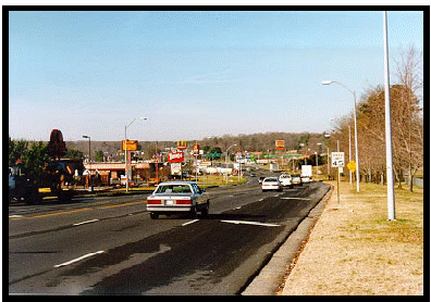
Figure 1. Existing U.S. 64 through Asheboro
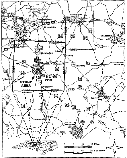
This case study discusses the project development phase for the intended improvement of the existing US 64 corridor near the City of Asheboro, North Carolina in Randolph County, in the center of the triangle created by Charlotte, Raleigh, and Greensboro. Designed to bypass Asheboro, the new 14-mile roadway, includes construction of seven interchanges. The roadway will be a four-lane, median-divided facility with full access control. The opposite directions of travel will be separated by a landscaped median about 70 feet wide. Total right-of-way along the new bypass will average about 300 feet, with additional right-of-way needed at interchange locations to account for the ramps.
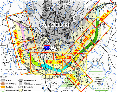
The project will also provide improved access to the NC Zoo, located in Randolph County. The proposed connection to the NC Zoo is a two-mile, two-lane parkway with full access control between US 64 and the NC Zoo’s entrance, plus a bridge carrying NC 159 over the NC Zoo connector. An interchange would connect the NC Zoo Connector to the proposed Asheboro Bypass west of NC 159. The bridge and landscaping along the parkway are being designed to provide an aesthetically pleasing entrance to the NC Zoo. NCDOT describes the design characteristics as being “similar to the Blue Ridge Parkway.” The cost estimate for the bypass and the NC Zoo connector is approximately $320 million.
Project Drivers
US 64 consists of three different segments in the project study area. West of Asheboro, toward Charlotte, US 64 is a two-lane undivided rural highway with a 45 mph speed limit. Through Asheboro, US 64 is a five-lane urban roadway with a 45 mph speed limit. East of the city, toward Raleigh, US 64 is a four-lane divided rural highway with a 55 mph speed limit. None of these segments has controlled access. Within the city limits, numerous driveways to shopping centers, restaurants, and businesses are located on both sides of the five-lane segment.
Figure 2. Study Area in Context
Average daily traffic volumes on US 64 range from 12,200 vehicles per day (VPD) on the two-lane segment west of town to 30,500 VPD on the five-lane segment through Asheboro. Traffic volumes are projected to increase by 177 percent or up to 54,100 VPD on the five-lane segment by 2025. The existing levels of service (LOS) are deteriorating in the project study area. Projected 2025 levels of service are LOS E and F for much of the study area. LOS E and F conditions cause significant travel delay, increase the potential for accidents, and contribute substantially to the inefficient operation of motor vehicles. The existing and projected poor levels of service result from traffic volumes being at, or exceeding, roadway capacities. Accident rates on the five-lane segment of US 64 are above the statewide average for this type of road, at 365.6 accidents per 100 million vehicle miles as compared to the statewide average of 354.5.
The declining levels of service for US 64 are especially troublesome because NCDOT designated this section of the highway part of the North Carolina Intrastate System. During the course of the bypass project development phase, NCDOT changed the designation to a Strategic Highway Corridor which, according to NCDOT, is consistent with the previous designation. With this designation, NCDOT aims for US 64 to provide high speed, safe, and convenient through-travel. NCDOT had implemented a Strategic Highway Corridor Initiative in order to identify, protect, and maximize the use of highway corridors that play a critical role in regional or statewide mobility. Prior to designating such corridors, NCDOT sought extensive stakeholder and public input.
Existing NC 159, the connection to the NC Zoo from US 64, is a two-lane rural road that winds through residential areas and has no access control. The NC 159 speed limit is 45 mph. When visitors leave the NC Zoo, the NC159/US 64 intersection can become very congested, and backups on NC 159 sometimes extend about 2.2 miles south. Because NC 159 is also the only outlet for adjacent residential subdivisions, congestion causes difficulty for residents accessing their homes. For many years, NC Zoo officials have petitioned NCDOT for road improvements to reduce this congestion.
Figure 3. Site Map
NCDOT’s goal for US 64 highway improvements is to improve traffic flow and levels of service in the study area. Local-level goals include relieving congestion on US 64 in the City of Asheboro, improving safety, and reducing the number of accidents. The NC Zoo’s goal is to improve access to the NC Zoo by reducing congestion and backups that occur on NC 159 from the mixture of traffic caused by NC Zoo visitors and local residents. Regionally, and to go along with the designation of US 64 as a Strategic Highway Corridor, an additional goal is to enhance high-speed regional travel along the Asheboro portion of the corridor.
Initial Concept and Planning
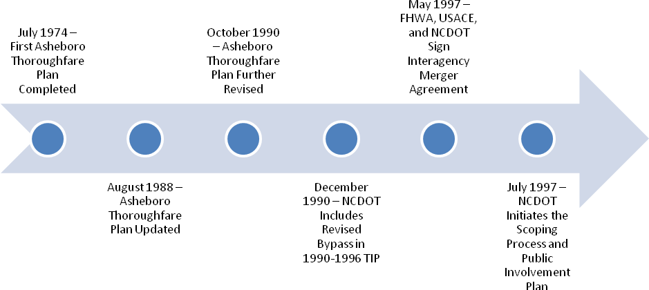
The City of Asheboro and NCDOT recognized the need for US 64 to eventually bypass the city many years ago. Long range planning for the bypass took place in phases, as is typical with a bypass project. As early as 1974, the city prepared The Asheboro Thoroughfare Plan. This plan contemplated two bypasses around the south side of Asheboro. The southernmost route of the two was to be access-controlled and was to include a new road to the NC Zoo. The city scaled back the Thoroughfare Plan in 1988, reducing the plan to include just one non access-controlled bypass and deleting the access road connecting the bypass to the NC Zoo.
In 1990, NCDOT prepared a feasibility study for a southern bypass. As a result of that study, the city again revised its Thoroughfare Plan, moving the bypass further south to avoid a developing area south of the city and reclassifying the bypass as a limited access facility. The city also put back into the plan a connection to the NC Zoo. NCDOT approved this concept in December 1990 and included this revised bypass in the 1990-1996 Transportation Improvement Plan (TIP).
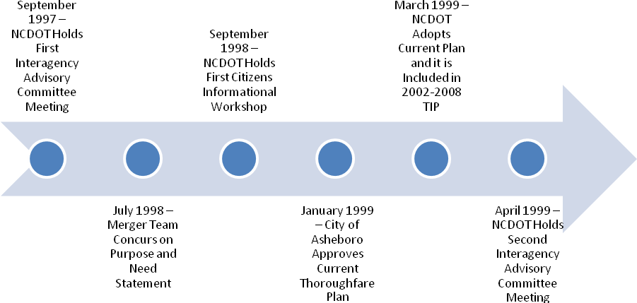
Although the city made changes to the Asheboro Thoroughfare Plan after 1990, the corridor for the proposed bypass did not change. The city approved the current plan in early 1999 and NCDOT adopted it that same year. The southern bypass is part of NCDOT’s 2002-2008 TIP and listed as Project Number R-2536.
Major Project Issues
Recognized as one of the nation’s finest zoos, the NC Zoo is located in the scenic Uwharrie Mountains, and is the nation’s largest walk-through natural-habitat zoo. The African and North American exhibit regions span more than 500 acres and include more than five miles of walkways. For many years, officials at the NC Zoo requested NCDOT’s assistance in relieving traffic congestion caused by arrival and departure of visitors. NC Zoo officials, however, wanted to avoid adverse impacts on the environmental features of the approach to the NC Zoo and, more importantly, the visual setting of the NC Zoo’s natural habitats. NC Zoo representatives apprised NCDOT of these concerns very early in the highway planning process and indicated their strong interest in being involved in the design of the improvements intended to serve the zoo.
In the course of comparing and contrasting the impacts of the nine alternatives that were carried forward to the draft bypass EIS, NCDOT realized that a Hispanic community could be particularly affected by four of the alternatives. Many of these community residents neither spoke nor read English. As a result, NCDOT realized that environmental justice concerns would need to be addressed in the EIS.
Internal agency management and procedural issues also arose. In the course of completing the EIS, NCDOT experienced several changes in the personnel responsible for the day-to-day management of the project development process. Within NCDOT, changes in project managers are not uncommon on major projects such as the bypass, given their normally long project development periods. From the beginning to the end of the EIS process, three different project planning engineers led the team. The original project manager retired and a subsequent internal reorganization resulted in project reassignments within NCDOT. Although it is not possible to quantify the extent of any delays in the project development process from these changes, NCDOT minimized their occurrence by keeping the second project manager on the EIS development team. Additionally, the consulting firm assisting NCDOT in the preparation of the EIS also experienced some turnover of key staff. As a result, production schedules were delayed as new staff became familiar with the project’s history and next steps.
Procedurally, these scheduling delays led to an unexpected gap in the time between the release of the draft EIS in July 2002 and the final EIS in March 2007. The completion of the final EIS had initially been scheduled for June 2005. Consequently, and in accordance with FHWA policy, once three years had elapsed without completion of the final EIS, NCDOT was required to re-evaluate the accuracy of its draft and determine if a new or supplemental draft was needed. NCDOT prepared a re-evaluation memorandum in October 2006 and documented the absence of any new significant information that would warrant the preparation of either a supplemental draft EIS or a new draft EIS.
Institutional Framework for Decision Making
The Merger Framework
NCDOT began scoping for the bypass EIS in July 1997. In May 1997, NCDOT signed an interagency agreement with the Federal Highway Administration (FHWA) and the U. S. Army Corps of Engineers (USACE) for the purpose of integrating or merging key EIS compliance steps with the initial steps required by the Corps for issuing an individual permit under Section 404 of the Clean Water Act. Most new highway construction projects require Section 404 permits, making integration an important strategy for FHWA and NCDOT. USACE, in turn, has duplicate NEPA responsibilities with FHWA because the USACE approval of a permit can also be subject to the completion of an EIS. With integration, the involved agencies can cooperate on the preparation of just one EIS, agree on the purpose and need for both the highway construction and the permit, and resolve any major permitting issues early through the avoidance or minimization of adverse impacts. The May 1997 Interagency Agreement evolved from a similarly intended 1992 agreement, but called for a more documented approach between the affected agencies.
As the first step in the application of the Interagency Agreement to a specific project, the signators were required to assemble a project team. The makeup of the team was intended to include experts from resource protection agencies with a special emphasis on wetland protection expertise. FHWA, USACE, NCDOT, U.S. Environmental Protection Agency (USEPA), U.S. Fish and Wildlife Service (USFWS), NC Wildlife Resources Commission (NCWRC), NC Department of Cultural Resources (NCDCR), and the NC Division of Water Quality (NCDWQ) all participated on the US 64 merger team.
Agencies participating in the merger process were to provide meaningful and early input on any likely impacts to resources within their purview and participate in issue resolution at the following major points in the EIS process:
- Development of the EIS purpose and need statement
- Establishment of the range of alternatives to be carried forward for full analysis in the EIS
- Selection of the preferred alternative
- Design of necessary bridges
- Identification of impact minimization measures
Additionally, USACE accepted the specific role of cooperating agency on the FHWA EIS. By so doing, USACE has the option of using this EIS as its own, thereby meeting NEPA compliance requirements that stem from the federal action of issuing a Section 404 permit. Rather than duplicating an EIS for the federal permitting action, the USACE, as a listed cooperating agency, can adopt the completed FHWA EIS as long as USACE can conclude that its comments and suggestions on the content of the EIS have been satisfied.
Community Involvement and Input
In July 1997, NCDOT prepared and subsequently implemented a public involvement plan for the bypass project EIS. The major provisions of the plan included a Steering Committee, a scoping letter and meeting, citizen informational workshops, local official meetings, newsletters, and a toll-free project information telephone line. Steering Committee members included representatives from the merger agencies, the NC Zoo, Randolph County, and the City of Asheboro. The Committee met twice in the early phase of developing the EIS. In the first meeting, members were provided a description of the project and a request for input on the scope of the study. The second meeting focused on a discussion of alternative project alignments.
Meetings with local officials were held just prior to the two Citizens Informational Workshops that NCDOT convened prior to the release of the draft EIS. Set up as informal open houses, the workshops were designed to encourage one-on-one discussions with members of NCDOT’s project team as well as its consultants. NCDOT held the first workshop in September 1998, and approximately 450 people attended. NCDOT described the preliminary corridors developed in the first stages of the planning process through the use of large project maps, slide presentations, and an aerial photograph of the project study area, which was produced at a scale large enough for viewers to locate streets, creeks, and other important local features. NCDOT also provided informational handouts and comment sheets.
NCDOT held a second workshop employing a similar open house format in June 1999, which focused on the nine alternatives that were under consideration for detailed study in the pending draft EIS. Approximately 450 people attended the second workshop. For new attendees who may have missed the first workshop, NCDOT presented a slide show that explained the purpose and need for the project, the EIS process, and the public involvement plan. NCDOT subsequently reported that it received 28 public comments from this workshop covering the following topics: “the time it takes to complete the study process; residential relocations; impacts to retirement homes; potential increased commercial development on the east end of the project; and the number of interchanges.”
The EIS public involvement plan also provided for a maximum of five small group meetings. The Randolph Rotary Club and the Asheboro/Randolph Board of Realtors requested meetings, which NCDOT provided.
The small group meeting provision in the public involvement plan also turned out to be a particularly important implementation tool given the project’s potential adverse impacts on the predominantly Hispanic community, Crestview Manor subdivision. Four of the nine alternatives in the EIS, including the preferred alternative, would bisect this subdivision. Consequently, in May 2001, NCDOT called a meeting of Hispanic community leaders in order to determine how to better inform this affected community about the proposed project. As a result of recommendations from the Hispanic leaders, NCDOT expanded its public involvement efforts to:
- Add Spanish and English messages to its toll-free hotline;
- Place public meeting announcements in Spanish media sources such as the local bilingual Hispanic newspaper, Que Pasa;
- Print subsequent project newsletters in Spanish and English;
- Post public meeting flyers in businesses frequented by the area’s Hispanic community;
- Use translators at subsequent public meetings; and
- Distribute informational materials to the public school serving the Crestview Manor subdivision for school children to take home.
NCDOT staff believes that working with the local school was particularly effective because the school children took the materials home to read with their families. As potentially affected families became aware of the project, they indicated a willingness to move with relocation assistance. In turn, NCDOT took substantive steps to reduce the impact on Crestview Manor. After the May 2003 Corridor Public Hearing, NCDOT added to the project’s design a bridge that would carry West Chapel Road over the proposed US 64 bypass. West Chapel Road runs through Crestview Manor and the bridge would provide access across the freeway and help maintain the cohesiveness of the community.
Collaborative Decision-making Elements
In the merger agreement, NCDOT, FHWA, and USACE agreed to a collaborative, or shared, decision-making process. The process is deemed “shared-decision making” because all agency representatives must reach a consensus on the decision at each merger concurrence point. Absent a consensus, the EIS process cannot advance to the next merger point. Additionally, if members of the project team cannot reach consensus, the May 1997 Interagency Agreement calls for the disputed matter to be referred to the NC FHWA Division Administrator, the USACE Wilmington District Engineer, and the NC State Highway Engineer. Consequently, achieving consensus is an important goal as well as a performance measure for all team members, especially those with a leadership role in the merger process: USACE, FHWA, and NCDOT. This consensus feature provides incentive for team members to communicate openly, listen to the resource and mission concerns of the other members, focus on priorities, offer solutions, and accept reasonable compromises.
For merger team meetings at which a concurrence point was to be addressed, all team members were expected to be physically present. The NCDOT project manager and the USACE representative led the meetings and facilitated an open discussion of the pending concurrence point. Approximately six weeks before a meeting, the team members were provided a packet of relevant project information to include any merger forms for their eventual execution. In the case of the US 64 Bypass, only one meeting was needed to reach consensus on each concurrence point except for concurrence on the preferred alternative. Two meetings were required for this decision but not because of any controversy over the alternatives’ potential adverse environmental impacts. Rather, two of the alternatives were viewed very favorably and team members needed more time to decide on one.
The EIS development process for the US 64 Bypass reflects an effective collaborative approach. At all merger points for the EIS, consensus was achieved through effective listening and NCDOT design revision that reflected the resource concerns raised by other team members. A primary example of this accommodation occurred at concurrence point 2A: Bridging Decisions. Based upon team members’ input on projected adverse impacts to wetlands, stream banks, and wildlife migration and feeding corridors, NCDOT added three bridges to the project design to minimize impacts.
Although the NC Zoo was not part of the merger team, NCDOT worked very closely with Zoo officials on the zoo-related transportation improvements. NCDOT included NC Zoo representatives on the Steering Committee and consistently kept them informed of all project developments. NCDOT requested NC Zoo recommendations for the design of the bridge and road connector to the Zoo and incorporated these recommendations into the project to the satisfaction of NC Zoo officials.
Collaborative decision making carries into North Carolina’s process for identifying wetland impacts and planning for efficient and environmentally effective mitigation of those impacts. North Carolina’s Ecosystem Enhancement Program (EEP) evolved from a multi-year effort by NCDOT, DENR, FHWA, USACE, NCWRC, USEPA and USFWS to streamline the project delivery process for transportation improvement projects, to reduce environmental impacts in concert with avoidance and minimization, and to produce the most environmentally beneficial mitigation possible. A year of multi-agency process improvement workshops determined that compensatory mitigation should be “de-coupled” from individual permits and project reviews, and performed on a watershed basis, with mitigation projects constructed in advance of permitted impacts according to collaboratively identified priorities.
The March 2007 final EIS for the Highway 64 project states that “the Mitigation Plan for jurisdictional impacts to streams and wetlands will be developed by the NCDOT during the Section 404/Section 401 permit application processes. Once on-site opportunities are exhausted, compensatory mitigation will be provided by the NCDENR Ecosystem Enhancement Program pursuant to the tri-party Memorandum of Agreement between USACE, NCDENR, and NCDOT (July 2003).” EEP adds a high degree of predictability to the permitting process for NCDOT and helps ensure that the investment will be targeted to achievement of the most important environmental objectives identified by local communities and agency partners in watershed plans.
Advance Identification of Wetland Impacts and How Impacts Will be Mitigated
Wetland impacts used to be a major barrier to project implementation in North Carolina and achievement of the state’s legislative objectives for extension of highway system capacity statewide. This barrier has been effectively surmounted with extensive interagency collaboration on development of an advance mitigation planning process administered through the state’s Ecosystem Enhancement Program.
NCDOT provides EEP an annual Project Impact Report of all anticipated wetland, buffer and stream impacts by year for seven years into the future for each 8-digit watershed and according to TIP project number and/or NCDOT Division operations impacts by year. For anticipated wetland impacts, the units are acres of riverine, non-riverine and coastal marsh; for buffers, the units are square feet; and for streams the units are linear feet. No further wetland type assessment is used or required, streamlining the delineation process. Quarterly updates are submitted throughout the year. NCDOT makes their initial forecasts from vegetation and landcover data layers. When more detailed information is available from technical reports in NEPA documents, that data over-rides the planning level estimates. By the minimization stage, approved permit drawings are available and NCDOT further minimizes impacts. Remaining impacts are mitigated through EEP according to the highest needs in each watershed and in conjunction with local communities.
EEP evaluates a variety of data and information on water quality and habitat conditions in each river basin to select Targeted Local 14-digit Watersheds where there are significant stressors, needs, and/or opportunities for restoration, enhancement, or preservation projects.
- Water Quality Problems and Land Cover: EEP targets watersheds with existing and potential water quality problems resulting from nonpoint source pollution. To make this determination, use support ratings, the 303(d) list, and water quality Basinwide Assessment reports are considered. EEP uses land cover data to evaluate riparian buffer condition to asses breaks to water quality and habitat degradation. Resource values considered in targeting local watersheds include public water supply, shellfish areas, outstanding or high quality resource waters, aquatic natural heritage elements, and regulated trout waters. As water quality studies suggest that heavily forested watersheds regulate stormwater runoff, thereby reducing the likelihood for severe streambank erosion, nutrient runoff and sediment pollution, EEP uses the percentage of cleared land in a watershed as an indicator of restoration need and opportunity.
- Watershed Approach and Partnership Opportunities. North Carolina’s watershed approach advocates concentrating multiple water quality projects in one relatively small watershed to yield a greater cumulative benefit to water quality. EEP aims to tie wetland and stream restoration projects with other efforts such as agricultural best management practices (BMPs), stormwater controls, and riparian buffer preservation to restore or improve entire watershed functions, not just streams and wetlands. For this reason, EEP targets areas with existing watershed planning or protection initiatives already underway and assesses the potential for partnership opportunities at the local watershed scale. EEP reviews existing or planned Clean Water Management Trust Fund and Section 319 projects, and considers if a municipality is located in the watershed, as cities are considered to often own good sites for watershed improvement projects but lack the technical expertise and the resources to implement the projects. In addition, many cities are subject to Phase I or Phase II Stormwater Regulations and gather monitoring information that is useful in designing and measuring the long term benefits of restoration efforts.
- Local Resource Professional (RP) Comments/Recommendations. The comments and recommendations of local resource agency professionals including staff with Soil & Water Conservation districts, the Natural Resources Conservation Service (NRCS), municipal planning and stormwater departments, NCDENR regional staff (e.g., Wildlife Resources Commission), and local/regional land trusts are considered heavily in the selection of Targeted Local Watersheds. Local resource professionals often have specific and up-to-date information regarding the condition of local streams, wetlands and riparian buffers. Furthermore, local RPs may be involved in local water resource protection initiatives (and the acquisition of funding for such projects) that provide good partnership opportunities for EEP restoration projects and/or Local Watershed Planning initiatives.
- High Quality Preservation (HQP). To facilitate EEP’s “in-ground-prior-to-impact” goal during the two-year transition period at the inception of the program, the EEP framers agreed that the use of high-quality preservation to complement a 1:1 restoration program. Strict criteria require that any site under consideration meet high standards for environmental quality, and/or contribute to broader environmental goals, and be under “demonstrable threat.” A minimum restoration provision of 1:1 is required to augment HQP acquisitions; however, the restoration can be delayed until the end of a two-year transition period. The provisions of the MOA also broaden the applicability of preservation credits to eco-regions, eight environmentally cohesive regions throughout North Carolina. This facilitates the purchase of larger and more environmentally important tracts of land that meet the criteria. DENR established a partnership with the Conservation Trust of North Carolina (CTNC) to serve as the program manager for the preservation program. CTNC works with North Carolina’s 23 land trusts to identify, assess, and document the natural significance of potential sites and to work with land owners to secure conservation easements where applicable.
Transportation Decision-making Process / Key Decisions
Concurrence Point 1: Draft Purpose and Need Statement
In July 1998, NCDOT called a meeting of the merger team to achieve concurrence on the draft EIS purpose and need statement. All of the merger agencies’ representatives attended, except for the NCDCR, who was represented by the State Historic Preservation Officer (SHPO). The SHPO could not attend but sent a letter in advance of the meeting stating that she had no comments on the draft statement. According to the meeting minutes, “No one voiced any major concerns regarding the draft purpose and need statement. Everyone agreed the document contained all the necessary information in an acceptable format.” NCDOT subsequently stated in the draft EIS that these minutes serve as documentation of the merger team’s concurrence on the project’s purpose and need. This concurrence was important for two reasons. First, it allowed the purpose and need statement to apply to both NCDOT’s highway construction project and USACE’s Section 404 permitting action. Second, the purpose and need statement discussed the need to meet the high-speed design requirements that stem from the Asheboro section of US 64’s designation as part of the North Carolina Intrastate System (later reclassified as a Strategic Highway Corridor). Consequently, NCDOT incorporated the need to provide high speed, safe travel into alternatives included in the EIS. As a result, any location and design alternative to be included in the EIS was required to meet this need.
Approximately one year prior to the July 1998 purpose and need meeting, NCDOT initiated several preliminary project development actions that provided input to the merger team. In July 1997, NCDOT sent a scoping letter to a variety of local, state, and federal agencies requesting their participation in the study process as well as any initial comments on the proposed project. NCDOT tabulated the comments received and developed responses for merger team’s review. Just over a month after the scoping letter was sent, NCDOT sponsored an initial coordination meeting, also called a scoping meeting. This meeting was attended by the merger team members. NC Zoo officials were present, in addition to representatives from the city and county, the Asheboro/Randolph Chamber of Commerce, and the local newspaper. NCDOT named the combination of representatives and the merger team members an “Interagency Advisory Committee.” The meeting was intended to obtain the attendees comments and inputs on the scope of the project, the process for considering alternatives and selecting those for detailed study, forms of acceptable mitigation, and any new concerns. Meeting minutes indicate that NC Zoo representatives restated their concerns for an appropriate design for the zoo connector. City and county officials expressed concerns about identifying a viable corridor as early as possible, to protect the corridor from development.
Concurrence Point 2: Detailed Study Alternatives Carried Forward
In April 1999, NCDOT reconvened the Interagency Advisory Committee for the purpose of receiving comments and input on the alternatives that should receive detailed study in the draft EIS. At the start of the project development process, 44 1,000-foot long segments were chosen for evaluation. After an initial screen, this number was reduced to 34 segments that were then combined to form 24 preliminary corridors.
NCDOT explained its method for reducing this number as follows:
The Geographic Information System was used to quantify impacts to features. Measurements such as the acreage of floodplains and wetlands, the number of historic properties, residences, businesses and churches, and the number of stream and minor road crossings within the corridors were included. These numbers were used to divide each feature into thirds, one third having the highest number of impacts, one third the lowest and a middle third. For each feature, the third of the corridors with the highest number of impacts were eliminated. The middle third was considered, and the highest preference was given to corridors in the third with the least impacts in each category. This process resulted in nine Detailed Study Alternatives being recommended by the NCDOT.1
NCDOT provided the merger team with public comments on its initial set of alternatives. The department then consulted with merger team members in the process of identifying features and determining or ranking features’ importance to agencies with associated resource protection responsibilities. Merger team members helped reduce the number of corridors eligible for further study through their identification of segments with significant resource issues. If other feasible alternatives were available without such issues, NCDOT placed those at the top of the list. For example, the SHPO raised concerns over an alternative labeled “Segment G4” because it could adversely impact the Cox Farm, a historic site eligible for listing on the National Register of Historic Places. Given this stated concern and coupled with the Section 4(f) compliance requirements that would be triggered by any adverse impacts to the Cox Farm, NCDOT proposed elimination of Segment G4 from further study. All merger team members concurred.
Based upon NCDOT’s analysis and consultations, the merger team members concurred with NCDOT’s proposed nine alternatives for detailed study. None of these nine alternatives would affect Section 4(f) resources. NCDOT documented the merger team’s concurrence through preparation and distribution of meeting minutes.
Concurrence Point 2A: Approximate Lengths of Bridges on Detailed Study Alternatives
At this concurrence point, the merger project team members made decisions on locations and approximate lengths of bridges. Decisions on bridge lengths are included in the merger process as a concurrence point because of their direct relevance in determining the project’s degree of potential impacts to resources such as wetlands, stream banks, water quality, and wildlife migration and feeding corridors.
The merger project team met on May 12, 2004 to make these decisions. Subsequent to the preceding concurrence point, NCDOT released the draft EIS for review and comment, held a corridor public hearing, and initiated work on the final EIS.
The meeting for this concurrence point took place in the field at the proposed bridge sites. Although some merger team members did not initially view field meetings, a relatively new tool in this collaborative decision-making process, a productive use of time away from the office, they soon found them to be very useful. Field visits allowed team members to better demonstrate their concerns, such as resource protection or highway design problems and limitations, and reach resolution on tradeoffs. The team members were able to better communicate and understand each other’s points, visualize alternatives, and develop practical solutions to identified concerns.
Because the proposed bypass would be a new road and would pass through predominantly rural areas, resource agencies were primarily concerned about the bypass’s potential impacts on several undisturbed natural areas possessing high quality streams. During a field visit to these areas with its engineering staff in participation, NCDOT agreed to add bridges over Little River, Vestal Creek, and North Prong Richland Creek with minimum lengths totaling 165 feet over each stream. The merger team also agreed that two 30-foot-long wildlife crossings would be constructed under each of these bridges, with appropriate fencing to direct wildlife to the crossings.
NCDOT also moved to a new method to document the merger team’s concurrence. Rather than referencing the concurrence in meeting minutes, NCDOT began to require each merger team member to sign a new form entitled “Merger Project Team Meeting Agreement.” The agreement included specifics, such as that it applied to Concurrence Point 2A and summarized the decisions reached. Then, the form was dated May 12, 2004, and was signed by FHWA, USACE, USEPA, USFWS, NCDOT, NCSHPO, NCDWQ, and NCWRC.
Concurrence Point 3: LEDPA/Preferred Alternative Selection
At Concurrence Point 3, the merger team’s goal was to reach consensus on the "least environmentally damaging practicable alternative" (LEDPA), which, for NEPA purposes, becomes the preferred alternative through the remaining project development and permitting processes. The team reached this decision during the May 2004 field visit described under Concurrence Point 2.
From the nine alternatives in the DEIS, the team selected alternative Number 29 as the LEDPA. NCDOT listed in the final EIS the primary reasons for selecting Number 29 as the alternative:
- Was the choice of the merger team
Other stated reasons were that, compared to the other eight alternatives, it:
- Affected the smallest area of wetlands;
- Was supported by local governments;
- Has the fourth lowest noise receiver impacts;
- Has the fourth lowest number of stream crossings at 23, compared to a range of 18 to 26 for the other alternatives; and
- Has a design that minimizes community impacts.
Concurrence Point 4A: Avoidance and Minimization
On May 25, 2006, NCDOT conducted a meeting of the merger project team for the purpose of reaching concurrence on avoiding and minimizing the project’s jurisdictional impacts to the extent practicable. In addition to the merger agencies, the Piedmont Triad Rural Planning Organization had a representative at the meeting. The team was again able to reach a consensus which was due in large part to the team’s previous concurrence on the three bridge additions and associated wildlife crossings. The consensus was documented with another concurrence form labeled “Concurrence Point 4A” and was supplemented with meeting minutes. The form summarized the agreed-upon mitigation measures for wetlands, streams, and noise.
With successful completion of this concurrence point, NCDOT and FHWA completed and released the final EIS in March 2007. The first pages of that EIS are composed of green colored sheets that summarize the project commitments made at Concurrence Point 4A. NCDOT uses these easily recognizable sheets to clarify for future monitoring purposes the specific mitigation commitments that it is making. Additionally, completion of this concurrence point, per the interagency merger agreement, fulfilled the requirements of avoidance as required by the USACE’s Section 404(b) (1) guidelines.
Arguably, the avoidance and minimization step on projects with new alignment has been greatly facilitated by North Carolina’s merger process and its connection to the state’s Ecosystem Enhancement Program. NCDOT avoids and minimizes to the maximum extent practicable before NCDOT is permitted to go to EEP to mitigate for unavoidable impacts. EEP then offers what the resource agencies consider a very good alternative in compensating for remaining impacts.
Remaining Merger Steps
NCDOT was drafting the record of decision (ROD) for the EIS at the time this case study was concluded. Following completion of the ROD, which is the last EIS step, the focus of the merger process shifts to concluding the Section 404 permitting process. NCDOT and FHWA must prepare a compensatory wetlands mitigation plan and submit it to the USACE for approval. USACE, in turn, considers the plan, discloses it to public interest review, and makes its Section 404 permit decision using the joint FHWA/NCDOT EIS as its NEPA compliance document.
Lessons Learned
Success Factors
Merger Process is Effective
The merger process for the development of the US 64 Bypass worked well for those concurrence points that were completed as of the date of preparation of this case study. The effectiveness of the process is evidenced by the fact that a consensus was reached at each concurrence point without any need to elevate an issue to team members’ senior managers. In terms of the bypass project, NCDOT has been able to plan a transportation project that meets its stated purpose and need while incorporating resource protection and impact minimization measures recommended by other team members.
The merger process procedures also worked as intended. For example, one of the agencies on the merger team included in its draft EIS official comments that NCDOT should have considered a lower speed parkway as an alternative, because it may lessen adverse environmental impacts. NCDOT briefly responded to this comment in the final EIS by pointing out that the suggested alternative did not meet the purpose and need statement, a statement with which all team members had previously concurred.
The merger team members interviewed for this case study complimented the merger process conducted for the US 64 Bypass, stating that they appreciated the open forum that the process provided for sharing information and expertise. The resource protection agencies were particularly pleased with their ability to give input regarding priority resource concerns, minimization approaches, and NCDOT’s good faith efforts to incorporate such approaches. Two of the federal agency representatives on the team who also review transportation projects in other states indicated that they would like to see other states develop a similar collaborative process. As the NCDOT approach has matured and evolved over the course of several years, an important factor contributing to its success has been the strong commitment of top management within NCDOT, USACE, and the FHWA.
Readily Available Experts Contribute to Communication
The major goal of the merger process is to achieve a team consensus at each specified concurrence point. Consequently, whenever a team meeting is set up for the specific purpose of reaching a consensus, it must be carefully planned so that the appropriate experts are present. For example, if resource agencies are asked to balance their resource concerns against highway safety and other design requirements, the agencies want the opportunity to hear directly from the hydraulics expert, review related data, and ask questions. As the merger process developed, NCDOT recognized this need and made a strong effort to have the appropriate experts available at concurrence point meetings.
Use of Visualization Technology Effective in Issue Resolution
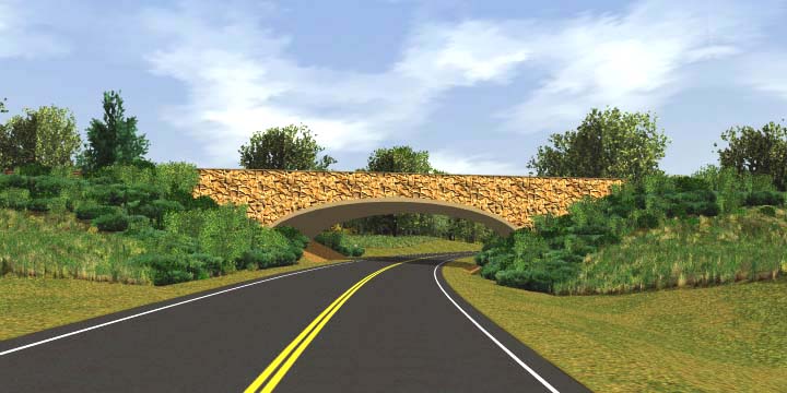
Although NCDOT and the NC Zoo established an effective working relationship, zoo officials had a continuing and fundamental open question on how the final design would meet its on-the-ground aesthetic and land use concerns. NCDOT resolved this question to the satisfaction of the parties by commissioning a video visualization that incorporated the NC Zoo’s input. The visualization effectively showed the natural design of a connecting bridge that was required as well as the parkway-like appearance of the connector road as it ran from the bridge to the entrance of the NC Zoo.
Funding For Review Officials at State and Federal Agencies
NCDOT recognized that for the merger process to work effectively, other state agencies involved in this planning and permitting process must be able to make project review staff available who are both experts in their agencies’ disciplines but also have some understanding of highway planning and construction. In order to meet this need, NCDOT pays for dedicated project review positions in other state agencies. This approach has allowed the funded agencies to more effectively participate in project development.
EJ Community Leaders Helped Design a Successful Outreach Strategy
NCDOT’s identification of the environmental justice concerns stemming from potential adverse impacts to the Crestview Manor subdivision was important, but expected, in terms of completing a comprehensive project development process. More notable is NCDOT’s initiative in addressing these concerns. Rather than planning an internal agency strategy for reaching this predominately Hispanic community, NCDOT first organized a meeting of Hispanic community leaders and requested their assistance in designing the strategy. NCDOT extensively used that input to reach the community and establish a successful dialogue.
Key Innovations
Field Visits Promoted Understanding and Communication
NCDOT started holding some of the concurrence point meetings in the field at around the time that US 64 Bypass was going through the initial concurrence points. As described above, NCDOT held the meeting for Concurrence Point 2A on bridge lengths and Concurrence Point 3 on the LEDPA in the field at the affected sites. These visits provided merger team members with the opportunity to view and consider resource concerns and design limitations. Team members found that the field visits not only promoted realistic compromises and tradeoffs, but made the tradeoffs much more understandable and acceptable to the team when the consensus vote was taken.
Signed Agency Commitments Solidified Concurrence
In the merger process for the US 64 Bypass, NCDOT documented the merger team’s consensus on Concurrence Points 1 and 2 by noting it in the minutes of meetings held for those concurrence points. Starting with Concurrence Point 2A for bridge lengths, NCDOT designed a concurrence form and requested each team member to sign it as evidence of concurrence. This signature step further solidified the process because it limited the likelihood that, absent some significant new or changed information, a member agency would revisit a completed concurrence point. Obtaining each agency representative’s signature also highlighted for each representative the importance of the decision that was to be executed and, consequently, the need to coordinate that pending decision within the representative’s own agency.
Elimination of Other Agency Pre-application Requirements
The merger process is premised on the early involvement of all agencies that have some jurisdiction over the design and construction of the proposed project. Consequently, this exposure eliminates or reduces the need for those agencies’ traditional project notification processes. For example, the NCDWQ no longer requires its own pre-application meeting and site visit but substitutes the similar merger steps for those NCDWQ steps.
Barriers Encountered and Solutions
Wetland Impacts on New Alignment Handled through Predictable, Efficient, and Effective Process Outlined by State Ecosystem Enhancement Program
Projects on new alignment are typically among the most difficult to get approved and permitted. North Carolina took a proactive approach to dealing with a scale of impending issues in this area virtually unheard of in other states. NCDOT and NC Department of Environment and Natural Resources (DENR) designed the Ecosystem Enhancement Program to deal with a rapidly expanding transportation program with a high volume of new alignments, impacting an estimated 6,000 acres of wetlands and a million feet of streams over a seven-year period from 2003-2010.
EEP protects the state’s natural resources through the assessment, restoration, enhancement, and preservation of ecosystem functions, and through identifying and implementing compensatory mitigation programmatically, at the watershed level. The program:
- Enables multiple project impacts (wetlands, stream corridor, water quality, species, and habitat) to be addressed in a comprehensive manner;
- Targets mitigation resources to better protect the natural resources of the state by assessing, restoring, enhancing, and preserving ecosystem functions and compensating for impacts at the watershed level. The program will address watershed concerns, including preservation of threatened high quality sites and restoration of wetlands and riparian buffers along impaired streams;
- Exceeds the state and FHWA’s “no net loss” objectives for wetlands;
- Allows implementation of mitigation years earlier than NCDOT’s project-letting schedule previously allowed, expediting projects and eliminating temporal loss of wetland and riparian areas;
- Reduces permit staff workload, rework and duplication of effort, saving time and money;
- Reduces project controversy and improve communication, planning, and environmental stewardship;
- Serves as a model for positive interagency relationships; and
- Dramatically increases the ecological effectiveness of the investments of public dollars in compensatory mitigation, illustrating better stewardship of public resources, and setting a nationwide standard for mitigation at the ecosystem level for unavoidable impacts resulting from transportation improvements.
The program has been endorsed at the highest levels of participating agencies, in particular, the Army Corps of Engineers. The high standards of the program, NCDOT’s support for and investment in it, and the goodwill generated with resource agencies have enhanced NCDOT’s credibility in resource agency negotiations.
Environmental Justice Problems Avoided by Crafting Outreach with Community Leaders
As previously explained, NCDOT initially encountered barriers in gaining participation from the Spanish-speaking residents of the Crestview Manor subdivision. Because four of the most feasible alternatives would directly affect this subdivision, it was crucial for NCDOT to hear the affected residents’ views and concerns on pending impacts and inform residents of relocation assistance. With the advice of Hispanic community leaders, NCDOT put in place a successful comprehensive outreach program that included bilingual written and verbal components plus a unique information effort with the local school. Community leaders supported the outreach program, which reached the residents and informed them of the pending project, their ability to participate in its planning process, and the financial assistance that would be available to any displaced residents. Based on input received in this process, NCDOT added a bridge to the project that will carry subdivision traffic over the bypass and prevent the bypass from fully dividing this Hispanic community.
Aesthetic Design and Land Use Compatibility Challenges Surmounted through Visualization
NCDOT faced another important issue with respect to the design of the NC Zoo Connector and its associated interchange bridge. Zoo officials wanted a design that was consistent with the natural setting of the NC Zoo and the environmental features of the surrounding area. NCDOT wanted to accommodate this request but faced some difficulties in doing so. NCDOT succeeded by listening very closely to the NC Zoo representatives in order to clearly understand their specific design needs and by requesting their input in the appearance of the bridge and the connecting road. NCDOT then directed its consultant to incorporate this input into a visualization of a bridge and conforming road. The consulting firm produced an effective CD/DVD visualization that was provided to the NC Zoo for review and comment. This visualization subsequently became the basis for the design consensus between NCDOT and the NC Zoo (see Figure 4).
Figure 4. Visualization of Bridge on Zoo Connector
Surprising FHWA with New Document Format Delayed Final Approval Process
For the final EIS, NCDOT decided to try a relatively new approach by preparing an abbreviated document. Rather than repeating much of the content from the draft EIS, the abbreviated final EIS contained and responded to the comments on the draft EIS and summarized the project’s status and the rationale for the preferred alternative. Unfortunately, NCDOT had not discussed this approach with FHWA prior to providing the abbreviated format for FHWA approval. Ultimately, FHWA’s final approval took much longer than normal because it required a legal sufficiency determination on the abbreviated approach.
Key Staff Turnover Caused Significant Delay, But Collaborative Interagency Process and High Level of Documentation Helped
Three different project planning engineers took the helm of the EIS and its associated merger process at different points. This turnover led to delays in overall project planning and the EIS document production schedule. These delays, however, were somewhat reduced because of the consensus that had been developed by the merger team members at the various merger points and the specific documentation that existed for this consensus. The new project planning engineers as well as the other agency representatives, new or existing, had the benefit of reviewing the existing merger documentation when they jumped into the ongoing planning process. More importantly, there was no need or incentive to stop the process and revisit previous concurrence decisions.
Appendix 1: Timeline of Events


References
Draft Environmental Impact Statement for US 64 Improvements - Asheboro, Randolph County, North Carolina, dated June 23, 2002 and prepared by U.S. Department of Transportation, Federal Highway Administration and North Carolina Department of Transportation
Abbreviated Final Environmental Impact Statement for US 64 Improvements - Asheboro, Randolph County, North Carolina, dated March 9, 2007 and prepared by U.S. Department of Transportation, Federal Highway Administration and North Carolina Department of Transportation
Endnotes
1 Minutes of Second Citizens Informational Workshop, Appendix G of DEIS