
US Department of Transportation
FHWA PlanWorks: Better Planning, Better Projects
Interstate 64 Corridor Study
Charlottesville–Albemarle MPO
PlanWorks is a web resource that supports collaborative decision-making in transportation planning and project development. PlanWorks is built around key decision points in long–range planning, programming, corridor planning, and environmental review. PlanWorks suggests when and how to engage cross–disciplinary partners and stakeholder groups.
I–64 is a primarily east–west corridor traversing the Commonwealth of Virginia. The CA–MPO and SAWMPO are within close proximity to each other along the corridor. Growing demand from commuters, interstate travel and freight movement have begun to impact corridor operations between these two MPOs during peak travel times, creating congestion, travel time delays, and driver safety issues.
- CA–MPO (lead agency) SAWMPO (partner agency)
- Total budget: $100,000 (CA–MPO $70,000, SAWMPO $30,000)
- Enhance regional and interagency communications
- Identify opportunities improve corridor operational and safety conditions
- Develop a planning document that identifies existing corridor conditions and safety issues
- Provide improvement recommendations that may be implemented and/or further studied
- Provide a template that other similar regions can use for corridor planning studies
Executive Summary
The purpose of the project was to facilitate interregional communication and cooperation between stakeholders that have infrequently coordinated in the past. The project evaluated existing conditions along the Interstate–64 (I–64) and US 250 corridor between Charlottesville and Staunton, VA. The project resulted in a plan including project recommendations to address safety, congestion, and truck traffic within the corridor. The I–64 Corridor Study focuses on developing a planning process to enhance regional communications between state and local transportation planning agencies, MPOs, transit providers, and stakeholders.
The Charlottesville–Albemarle MPO (CA–MPO) led the study with assistance provided by the Staunton– Waynesboro–Augusta MPO (SAWMPO) and input provided by a working group comprised of staff from the CA–MPO, SAWMPO, two VDOT districts and
Central Office, local governments, DRPT, rail operators, law enforcement, and FHWA. The work group met six times and was charged with gathering relevant corridor information including studies, transportation performance measures, corridor deficiencies, and needs. Working group meetings focused on different topic areas and provided the MPO staff the opportunity to engage in the SHRP2 Corridor planning process.
Key outcomes from the project include the formal establishment of a cooperative Memorandum of Understanding (MOU) between CA-MPO and SAWMPO. The MOU laid out a structure for continued collaboration and cooperation between the MPOs. A key component of the MOU is an agreement to host an annual joint MPO meeting that will include a report on the I–64 corridor.
Corridor Challenges
The 40 mile I–64 corridor between the cities of Charlottesville and Staunton is the primary east– west route that connects Virginia's Piedmont and
Shenandoah Valley regions. The corridor includes I–64, US Route 250, and the Buckingham Brand Railroad and is the connection between two MPOs: CA–MPO and SAWMPO. Geographically, the two MPOs are separated by only eight miles, but seem much farther apart due to the topography of the region, and land use constraints that limit the widening of I–64. The two regions connect at Afton Mountain where I–64, US Route 250, Buckingham Branch Railroad, Amtrak, and CSX Railroad all converge to pass over or through the mountain. Land use constraints are compounded on either side of the Afton Mountain where the entrances to the Shenandoah National Park and the Blue Ridge Parkway also meet.
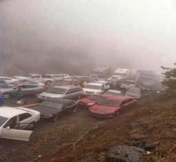
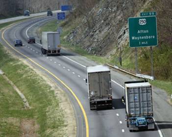
Other tourist and outdoor enthusiast attractions along the corridor include the Appalachian Trail, Rockfish Gap, and the historic Crozet Tunnel which, once restored, will be the longest bicycle/pedestrian trail east of the Mississippi. Despite the perceived distance, the economic health of the two regions are bound together by the I–64 corridor which provides access to Virginia's other major north–south and east–west transportation corridors. Motorists may encounter inclement weather conditions along the I–64 corridor often leading to multi–vehicle collisions, especially on the approach to and on Afton Mountain (see Figure 1).
Travel Demand Modeling has identified significant commuter demand along the east–west corridor with a large number of workers living in the SAWMPO region who commute to the CA–MPO region. The railroads frequently encounter bottlenecks along the Buckingham Brand Railroad during Amtrak service hours. Freight transportation demand on the east–west corridor is expected to increase. Additional operational impacts may occur from the Port of Virginia due to increasing container shipments following the Panama Canal expansion. New and expanding manufacturing facilities in Virginia are also likely to impact corridor operations. Regardless of their close proximity and complexity, these regions communicate infrequently, even though they are relatively in close proximity to each other along this Critical Corridor of Statewide Significance (CoSS).
The study focuses on how organizational processes could be enhanced to improve the way transportation decisions are made for this corridor.
Previous attempts to coordinate activities along the corridor have had limited success and have been ad– hoc in nature. The I–64 Corridor Study uses the PlanWorks Corridor Planning Decision Guide to build upon previous ad–hoc successes and officially codifies inter–regional cooperation through an MOU. The MOU includes specific action steps and sets the goal for having yearly joint MPO policy board meetings.
Product Implementation
Decision Guide
The Corridor Study addresses the first seven of nine decision points in the corridor planning framework. In addition to the Decision Guide, the team referenced other resources for guidance and to assist when planning reached key sticking points among the stakeholders.
The structured nature of the decision guide provided a clear process to follow while maintaining flexibility to work with the unique set of circumstances encountered in the I–64 corridor study.
The I-64 corridor planning process was structure by a small project team comprised of staff from the CA–MPO and the SAWMPO. The study team guided the process and was responsible for implementing PlanWorks and coordinating planning efforts with a working group. To ensure success, the project team took time early in the process to educate stakeholders on the PlanWorks corridor planning process.
COR–1: Approve Scope and Process
At the first project meeting in November 2016, the project team defined the geographic, temporal, and technical scope of the study and set up a project–specific webpage to serve as a data repository.
COR–2: Approve Problem Statements/Opportunities
At the second project meeting in January 2017, the project team worked towards agreement among stakeholders on the deficiencies and potential opportunities. Working collaboratively with the working group, project staff identified the following deficiencies/areas of concern in the corridor:
- Congestion during peak hours
- Backups and accidents caused by slow moving trucks ascending steep grades
- Safety concerns related to vehicle wildlife conflicts, weather and climatic phenomenon
COR–3: Approve Goals for the Corridor Study
With the deficiencies and opportunities identified, the project team set out to identify a set of goals for the corridor planning process at the third working group meeting in March 2017. MPO staff developed framework goals through a collaborative process and presented them to the corridor working group. Members then provided some input and further refined the goals and the subsequent objectives were also presented to each of the MPOs' Technical Committees and Policy boards for additional input. The corridor goals are reflective of the project and are focused on providing the higher– level overview of the corridor.
COR–4: Reach Consensus on Scope of Environmental Review and Analysis
At the fourth meeting in May 2017, the project team reached an agreement on data needs and future analysis levels required for the planning process/NEPA review.
The Eco–Logical tool guided the determination of the data, information and level of analysis needed to review conceptual solutions; Eco–Logical related datasets were gathered for the corridor study area Regional Ecological Framework (REF).
COR–5: Approve Evaluation Criteria, Methods, and Measures
At the fifth meeting in July 2017, the project team worked with VDOT to source data for the corridor evaluation criteria. The criteria used for hotspot identification and analyses were based in large part on Virginia's Smart Scale process, specifically, the guidance developed for the Smart Scale Round 2. Many of the measures are very similar to those used by the CA–MPO in the development of the 2040–LRTP, a plan that was developed utilizing a prior version of PlanWorks.
COR–6: Approve Range of Solution Sets and COR–7 Adopt Preferred Solutions Sets
Based on the results of the deficiencies analyses and input from the working group, the team identified a set of draft project recommendations. This list was the reviewed and vetted by the working group and a special meeting with the VDOT districts. Once the list was narrowed down, the staff developed profiles of each project recommendation and mapped them. The narrowed down list was then approved by the working group at the September meeting. Further vetting of project lists was done at a joint MPO Policy Board meeting in September.
Figure 2. I–64 near Afton Mountain.
Assessments
Early on in the corridor planning process the project leadership team used the corridor self–assessment Excel tool and the online stakeholder collaboration assessment tool to help better understand how to address issues of collaboration and communication with the project's large and varying coalition of stakeholders. These tools helped the project leadership team address conditions from thick fog, rain, and snow along the 11 miles between Waynesboro and Crozet. Using a detailed project scope, the project leadership team was able to effectively coordinate corridor planning related tasks and keep things moving forward. They developed a project specific scope of work through a collaborative process between the two MPOs which allowed for a better understanding of roles and responsibilities.
Applications
Having previously been involved in implementing Eco–Logical, the CA–MPO was able to integrate Eco– Logical related products and best practices into the Corridor Study. This included taking a corridor wide look at potential environmentally sensitive habitats integrating some new statewide predictive habitat models into the corridor planning. They integrated Eco– Logical by including resource agency partners in the stakeholder group, and by using local and statewide environmental datasets and models.
Library
The PlanWorks online library was used to identify relevant case studies and resources for similar projects.
The study leadership team also used the library as a reference tool when developing the project scope.
Additionally, the library was a great resource for the study team, providing ideas for next steps and ways that some of the plan outcomes could be implemented.
Stakeholder Collaboration
The I–64 corridor study was a collaborative effort among multiple stakeholders. Stakeholders provided the study team with a wealth of knowledge regarding the I–64 Corridor to assist the study team with the planning process. Each stakeholder meeting covered specific topic areas identified in the SHRP2 toolkit and provided opportunities for stakeholders to learn from subject matter experts.
- The Virginia Transportation Research Council provided the group with data analysis on vehicle wildlife crashes and introduced potential measures to reduce and prevent future
- Staff with the National Park Service updated stakeholders regarding current and future development trends in Shenandoah National Park and how these trends impact the I–64 Corridor in terms of freight transportation.
- Virginia State Police reported on vehicle crash investigations on I–64 corridor and identified the challenges police have when investigating crashes.
- VDOT Stanton District discussed I–64 Corridor operations management.
- DPRT participated in working group discussions and provided resources and guidance related to transit issues and inter–regional transit operations.
- Local governments provided data and their perspective relevant to the portion of I–64 in jurisdiction.
- Economic development experts provided stakeholders with a clear picture of the efforts underway to expand economic development opportunities along the corridor.
- CA–MPO and SAWMPO coordinated, organized, and facilitated working group meetings, developed and maintained study web–pages on each of their websites and developed maps, produced study materials, and hosted public information meetings.
Key Outcomes
The PlanWorks Decision Guide provided a framework that was easy to use and could be easily tailored to the planning needs of the I–64 corridor project. The Decision Guide was a rich resource of information with helpful resources and case studies organized around each step in the planning process. The PlanWorks methodology was especially useful in that it helped keep the project on track and provided a framework for bringing together a larger coalition of stakeholders. Many of the PlanWorks resources were also useful when the process became bogged down. At these points project staff utilized the PlanWorks assessment tools, policy questions and case studies to see how others had addressed similar issues.
Frequent communication and coordination helped keep the study moving forward. Project leads at the MPOs/ PDCs were in frequent communication and scheduled regular check–ins between working group meetings.
This allowed the project leaders to develop effective lines of communication and keep the project coordinated. Additionally, the communication efforts undertaken enabled MPO staff to update their boards and VDOT staff about the study. This type of communication between different MPOs was a key strength of the corridor project. To further maintain a high level of communication between the MPOs, a corridor specific MOU was executed which formally states how corridor specific communication will continue.
Having a small project leadership team was a critical component of the structure of the Corridor Study. This allowed decisions to be made quickly and effectively. It also reduced communication backlogs and the potential for conflict within the project team.
The study team was coupled with a larger stakeholder group. This proved successful because the stakeholder model allowed a wide range of stakeholders to participate and provide their input during the corridor planning process. This model was successful because each stakeholder meeting covered a separate topic and provided opportunities for the stakeholders to hear from subject matter experts. Structurally, providing the stakeholders with clear guidance at the beginning of the process reduced potential confusion and conflict later on.
By focusing on cost–effective solutions that work to maintain the corridors assets and improve the deficiencies, the leadership team found it easier to get buy–in from stakeholders which included the MPO policy boards and VDOT construction districts. Many of the solutions identified by the planning documents are compatible with the VDOT Strategically Targeted Affordable Roadway Solutions (STARS) program.
Lessons Learned
Overall the project team and working group had a very positive experience using PlanWorks. The MPO believes that tools like PlanWorks are beneficial to smaller MPOs with limited resources, especially in enabling such MPOs to incorporate innovative planning techniques into their operations.
One area for improvement is that the project time frame was challenging for the team. There are many factors that influence the planning process such as uncertainties around the future transportation funding and changing priorities on the state level.
The availability of some resources that explain the PlanWorks process in terms that the uniformed public can grasp, would be a great additional resource for anybody having to explain PlanWorks at a public meeting.
A full copy of the Decision Guide for the Corridor Planning kit that is downloadable as a single PDF would also be useful to educate partners and project participants about PlanWorks.
The corridor project also faced the challenge of maintaining interested parties and encountered situations where things didn't go as well as planned. For the corridor planning project these included maintaining interest from working group members whose participation decreased over the 6 meetings. The project also suffered initially from the lack of a clear purpose.
Next Steps
The I–64 Corridor Study identifies multiple improvement opportunities and recommends 29 improvement projects to be implemented to achieve the plan's goals and objectives. Corridor improvement recommendations include adding Park and Ride lots at specific exits, improving interchanges, installing wildlife exclusion fencing along I–64, enhancing and adding roadside communication equipment to improve corridor operations, and adding interregional transit between the two regions. All recommendations may be funded through Virginia's SMART SCALE transportation funding pro– gram. Future efforts to advance study recommendations along the I–64 corridor include:
- Continuing to communicate and involve the Corridor Study stakeholders to advance study recommendations and projects;
- Working with VDOT and localities to identify project sponsors for unfunded corridor improvements;
- Identify funding sources to implement corridor improvement projects;
- Evaluating and adding unfunded corridor improvement projects;
- Addressing inter–regional transit needs
- MPOs supporting one another's efforts and assisting local jurisdictions to implement improvements along the I–64 corridor.
For More Information
Contacts
Wood HudsonTransportation Planning Manger
Charlottesville–Albemarle MPO
(434)979–7310
info@tjpdc.org Reena Mathews
Transportation Specialist
FHWA Office of Planning
(202)366–2076
reena.mathews@dot.gov