
US Department of Transportation
FHWA PlanWorks: Better Planning, Better Projects
Curtis Road Corridor Study
Champaign County Regional Planning Commission
- 18–month corridor study
- 4.6 miles of roadway with a rural cross–section on the periphery of an urban area
- 10 local jurisdictions within and/or immediately adjacent to the study area
- 10 different agencies on steering committee: 8 local agencies + State DOT + FHWA
- 5 additional local and state environmental agencies on environmental working group
- 13 years = length of time the future of this section of roadway has been unresolved: this corridor study has been included as a regional priority project in the most recent LRTPs (2004, 2009, and 2014)
- 80 percent = amount 24–hour traffic volumes have increased in a portion of the corridor between 2006 and 2016
Agency: Champaign County Regional Planning Commission
Transportation decision–making phase: Corridor Planning
Executive Summary
The key challenge of the Curtis Road Corridor Study was to find an innovative and cooperative approach to improve the safety and functionality of a rural roadway on the edge of an urban area connecting distinct land uses and municipalities with seemingly competing priorities. Despite being listed as a regional priority project in the three most recent Long Range Transportation Plans (2004, 2009, and 2014), the Curtis Road Corridor Study has been difficult for the local Metropolitan Planning Organization (MPO) to get support for due to overlapping jurisdictions and sensitive land uses. Accounting for the impact of future transportation infrastructure improvements on the environmentally sensitive and academically important agricultural research land within the corridor made this study uniquely contentious. To carry out the Curtis Road Corridor Study, MPO staff utilized PlanWorks to create a collaborative and transparent corridor planning process involving many local agencies, as well as local roadway users, residents, and property owners to obtain input on the corridor and to promote awareness of environmental sensitivities and local transportation issues. By bringing together stakeholders to define collective goals for the corridor and future scenarios, this planning process strengthened the existing working relationships among local agencies and residents. The approval of the Curtis Road Corridor Study in 2017 represented the achievement of a long–time regional priority.
Agency's Challenge
The goal of the Curtis Road Corridor Study was to improve safety and mobility within and between the surrounding jurisdictions as well as support and protect the disparate surrounding land uses, including the world–renowned University of Illinois agricultural research and educational fields known as the South Farms. This corridor is located on the periphery of the Urbanized Area connecting the City of Urbana (pop. 42,044) and Urbana Township (pop. 7,282) on the east end of the corridor to the Village of Savoy (pop. 7,879) and the City of Champaign (pop. 84,513) on the west end. In the middle of the corridor, between the aforementioned jurisdictions, are the University's South Farms where farm equipment transportation, animal crossings, and a variety of environmental sensitivities present barriers to improving safety and connectivity between the growing populations and development to the east and west. Each of these entities has a variety of requirements for access to residential properties, public recreation space, commercial uses, the 200–acre University Research Park, a railroad, and university athletic facilities/stadiums within and immediately adjacent to the corridor. Given the number of agencies involved in the area and the past difficulties compromising over transportation goals for the future, the MPO was the logical party to carry out the study on behalf of and in cooperation with all the agencies. In addition, with the corridor study funding coming from an external source, there would be no pressure on any of the agencies to find the money to help fund the study or to determine the most fair way to contribute according to different budgets, populations, interests, or land and roadway ownership. Rather than financial support, each of the agencies committed to providing staff time to help oversee and complete the corridor study. From the start, the MPO set out to conduct a corridor study that was collaborative in nature and directed by a representative Steering Committee made up of agencies with land, roadways, or operations within or adjacent to the study area. Understanding that the study would require thoughtful communication, collaboration, and compromise, MPO staff were committed to using the PlanWorks Decision Guide for Corridor Studies to provide a clearly–defined set of decision points for the disparate parties involved. The PlanWorks Decision Guide provided clear expectations for each project partner and stakeholder in terms of when and how mutual collaboration and compromise would be expected and essential to move forward. The Decision Guide made it easy for Steering Committee members and other project participants to know where they were in the process and what their role was at any given time. In addition, the PlanWorks Assessments allowed MPO staff to evaluate the ongoing collaboration and ensure each partner was productively engaged at each step. The Curtis Road Corridor Study also utilized the Natural Environment and Implementing Eco–Logical application in PlanWorks in order to more fully incorporate environmental concerns into the corridor study while also preparing any future corridor improvement project for compliance with the National Environmental Policy Act (NEPA). An Environmental Working Group was established, made up of regional environmental experts, to oversee the use and documentation of the Natural Environment and Implementing Eco–Logical application throughout the process. Setting up a separate working group to focus entirely on environmental issues in the corridor was an efficient way for MPO staff to bring environmental expertise to the process when relevant without the Steering Committee getting bogged down in environmental topics they weren't trained or equipped to deal with.
Corridor Planning Phase of the Decision Guide:
- Approve scope of corridor plan process
- Approve problem statements and opportunities
- Approve goals for the corridor
- Reach consensus on scope of environmental review and analysis
- Approve evaluation criteria, methods, and measures
- Approve range of solutions sets
- Adopt preferred solution set
- Approve evaluation criteria, methods, and measures for prioritization of projects
- Adopt priorities for implementation
Assessment: Partner Assessment
Application: Natural Environment and Implementing Eco–Logical
Product Implementation
Decision Guide
1. Approve scope of corridor plan process
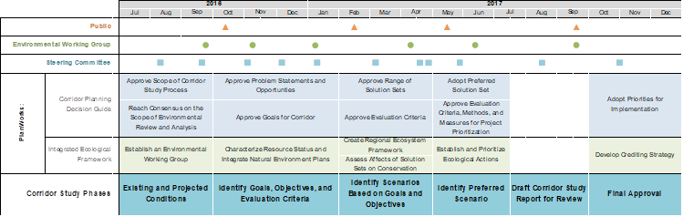
MPO staff started by identifying stakeholders to serve on a steering committee for the project and then drafting a timeline and work plan to kick off the process. At the first meeting of stakeholders, MPO staff announced the beginning of the Curtis Road Corridor Study project, presented the parameters of PlanWorks, and invited meeting attendees to serve on the study's Steering Committee that would meet regularly throughout the process to provide direction and make key decisions. The invited stakeholders reviewed the scope and timeline of the study and discussed the study area, area of influence, and the inclusion of the Natural Environment and Implementing Eco–Logical application as part of the study. The outcomes of this meeting included an approved scope and timeline for the study (see Figure 1 below) (COR–1), an approved study area, an expanded area of influence, ideas for establishing an Environmental Working Group to oversee the Natural Environment and Implementing Eco–Logical application, confirmed representatives from each partner agency to serve on the project Steering Committee, and invitations to additional agencies to be included in the Steering Committee. After the meeting, MPO staff worked on contacting the additional agencies to serve on the Steering Committee and recruiting members for the Environmental Working Group. In addition, MPO staff presented the corridor study separately to the University of Illinois College of Agricultural, Consumer, and Environmental Sciences (ACES), who owns and operates approximately 50 percent of the land in the study area for agricultural research purposes. The group discussed their role in the corridor study process and provided input on current and future land use plans.
During the first three months, MPO staff documented the existing conditions of the corridor by collecting and analyzing data on emergency services, utilities, non–transportation facilities, land use and zoning, future development, physical setting, environmental conditions, and details about the current transportation conditions including road geometries, travel flow, and safety statistics. The projected conditions were also documented through the analysis of future land use plans and updated regional population and employment projections from the 2040 Long Range Transportation Plan approved in 2014. The existing and projected conditions portion of the corridor study includes analysis and documentation of data and verification of data with stakeholder agencies and members of the public who live, work, and/or travel through the area. During this time staff was also gathering information for the travel demand model as well as preparing for scenario development and upcoming public meetings.
Figure 1: Curtis Road Corridor Study Timeline
2. Approve problem statements and opportunities, and
3. Approve goals for the corridor
Key decisions 2 and 3 went hand–in–hand in this process. The process of identifying and collectively agreeing on the problems and opportunities for the corridor naturally included identifying and collectively agreeing on the goals for the corridor, it was essentially the same task with two separate but related outputs: 1. problem and opportunity statements, 2. corridor goals. In reality, the process of defining the goals and opportunities started years ago when plans for this corridor were stalled due to competing goals from the surrounding jurisdictions and landowners. Anticipating conflicting opinions about goals for the future of the corridor during this study, MPO staff designed a process that would use public input as the foundation for the problem and opportunity statements and the corresponding corridor goals as well as the future scenarios. This part of the corridor study included the first public meeting to gather the public input that would lay the foundation for several future steps in the corridor planning process. After the first public meeting staff spent considerable time processing the input and organizing it into "Problems and Opportunities" statements with additional input from the Steering Committee and the Environmental Working Group. The "Problems and Opportunities" statements serve as the foundation for the corridor's goals, which determine the evaluation criteria by which to assess proposed future scenarios. The evaluation criteria are also dependent on the modeling tools staff use during the scenario development and evaluation process. The interconnection between the public input, problem statements, goals, evaluation criteria, and modeling tools makes this the most foundational and time–consuming portion of the corridor study.
4. Reach consensus on scope of environmental review and analysis
At the second Curtis Road Corridor Study Steering Committee meeting, staff presented the project scope and timeline, gave an overview of the draft existing conditions data, and discussed the project's first public meeting tentatively scheduled for October. This meeting also included a confirmation of the Curtis Road Environmental Working Group as well as a consensus on the Scope of the Environmental Review and Analysis (COR–4). It was determined that the Environmental Working Group would help inform the environmental data included in the existing conditions portion of the corridor study, as well as work on a more detailed "Environmental Report" that would speak more directly to possible future NEPA requirements to include as an appendix to the study.
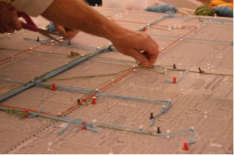
Figure 2: Public meeting participants mapped their Curtis Road routes using string
The first public meeting for the Curtis Road Corridor Study was held on a weekday evening at a church on the northern border of the study area. Although not many people live within the study area (since over 80 percent of the land area is agricultural) MPO staff was aware that local residents have strong feelings about the study area in particular and more generally about areas on the periphery of the urban area that could be susceptible to "sprawl" development. Staff used a variety of methods to advertise the meeting including newspaper ads, emails to various agency and neighborhood listserves, and social media posts. In order to capture people who use the roadway but might not live in the immediate community, staff had 40 yard signs made to post along the roadways around the study area to advertise public meetings. Staff also set up a project webpage that contained background information about the project, event announcements and archives, and staff contact information.
Over 80 people attended the first public meeting to learn more about the corridor study and to provide input. At the meeting, staff collected input regarding the current strengths and weaknesses of the corridor as well as their vision for the future of the corridor in the form of surveys, interactive maps (see Figure 2), information boards, and informal conversations. The input from the first meeting will inform the future steps of the study including defining problems statements, corridor goals, evaluation criteria, and future roadway improvement scenarios. At this first meeting, some meeting attendees were suspicious about the motivation of the corridor study and were afraid the planners in charge of the study already had plans for future roadway expansion. Staff tried to communicate the purpose of the meeting was gather their input to define the problems and opportunities that would drive the visioning process. For those attendees who were still suspicious or angry about the study, staff encouraged them to provide as much feedback during the meeting as they were comfortable providing and to stay engaged in the process by signing up for the listserve and/or visiting the website to find out about future meetings. After the meeting CUUATS staff posted the meeting materials on the project website.
During this phase, managers and administrators of the College of ACES at the University of Illinois hosted a tour for the corridor Steering Committee and MPO staff to highlight operations and activities that could influence planning and ultimate decision making for the Curtis Road Corridor. Curtis Road bisects land in the heart of the ACES South Farms, which are the field research laboratories of the world–renowned agricultural research portfolio of the College of ACES. ACES land accounts for about 50 percent of the land within the study area and the operations include a unique set of mobility and improvement needs specific to the public roadway. The tour was very informative for the corridor study's Steering Committee members and MPO staff regarding the land uses and mobility needs of the ACES operations.
During this phase staff held two Environmental Working Group meetings where group members from the Illinois State Geological Survey, the Illinois State Archaeological Survey, and the Champaign County Soil and Water Conservation District gave updates about their work or research related to the corridor. At one meeting a drainage tile map submitted by the conservation district was reviewed since drainage is a big problem in the corridor. During this phase, MPO staff presented a summary of public input received at the first public meeting regarding the corridor's strengths, weaknesses, and future possibilities to the Environmental Working Group and led group members in an activity to help brainstorm/develop problem statements and opportunities for the corridor, as well as identify specific sites that could be environmentally sensitive.
Processing the combined input from the public, the Steering Committee, and the Environmental Working Group, five over–arching themes emerged as corridor priorities: roadway deficiencies, agricultural preservation, modal interrelationships, environmental protection, and system linkages. MPO staff working with the Steering Committee to develop each of the five themes as its own "problem and opportunity statement" including goals and draft evaluation criteria for each statement. The Steering Committee approved the problem and opportunity statements (COR–2) as well as the goals for the corridor (COR–3). Chapter 4: Problems and Opportunities includes a summary of the problem statement, a description of the problem, goals, objectives, and evaluation criteria associated with each statement, as well as a map and images illustrating the summary and some relevant public comments.
5. Approve evaluation criteria, methods, and measures, and
6. Approve range of solutions sets
With defined goals for the corridor based on the "Problems and Opportunities," the next phase of the study involved identifying evaluation criteria and future scenarios (AKA solution sets) that can address those goals in a measurable way. The evaluation criteria are intended to quantify and compare the effectiveness of different scenarios in addressing the corridors goals. Part of the evaluation criteria required updating the travel demand model (TDM) by incorporating updated population and employment projections and developing a microsimulation for the study area. The rest of the evaluation criteria will require both qualitative and quantitative manual calculations. Staff will model, calculate, and document the evaluation criteria for the proposed future scenarios with the horizon year of 2040, as well as for a baseline/do–nothing scenario that assumed no future changes. In order to start the process of identifying future scenarios for the corridor, staff began with a second round of public input.
The second public involvement event for the corridor study was held at the same location as the first public event (a church on the northern border of the study area). The structure of this event was a longer–format workshop, held on a Saturday, in order to get participants to work together and consider the future of the corridor in a more thoughtful way. Staff advertised the meeting via the corridor study's listserve, two separate legal and retail listings in the local newspaper, the MPO Facebook page, Nextdoor.com, and road signs around the study area.
In preparation for the public workshop, staff developed a presentation of the problem and opportunity statements as well as the related goals for the corridor that were developed from the input from the previous public meeting. Meeting attendees filled out a survey in response to the problems and opportunities as defined by MPO staff where they had the opportunity to provide additional input on them and rank them in order of importance. To build on that input for the next phase of the corridor study, MPO staff also arranged an activity that would allow community members to work in groups to articulate their vision for the future of the Curtis roadway and surrounding area in the year 2040. Staff prepared large–scale land use maps with existing building footprints and environmental features of the corridor to serve as the base map for the activity. To go along with the maps, staff designed transportation improvement graphics for each roadway segment and intersection with different lane configurations, bike facilities, and intersection control types. At the meeting, eight groups formed and each group was provided a set of materials and a MPO staff facilitator to carry out the activity. Groups' future visions were limited by a predetermined budget, which helped them to prioritize the projects that are most important to them. The result was eight (8) different maps of the study area, one for each group, that illustrate a different future scenario for the roadways within the study area. Each of the scenarios was unique and collectively, they presented a wide range of possibilities for pedestrian, bicycle, automobile, transit, and agricultural vehicle mobility in the area. After the meeting CUUATS staff posted the meeting materials on the project website.
Following the public workshop, MPO staff held a Steering Committee meeting to provide a summary of the second public meeting and present the future scenarios developed by the public as the full range of solution sets that will be evaluated along with a baseline or "do nothing" scenario. The Steering Committee discussed the solution sets to ensure there was a good range of options presented and to get a better idea of how their analysis will be presented to the public at the next public meeting. The group approved the range of solution sets that will be evaluated (COR–6) and also discussed how the scenario analysis would inform the preferred future scenario and the development of final recommendations for the future. In addition, MPO staff and the Steering Committee re–visited the draft evaluation criteria presented along with the corridor goals. Now that staff and the Steering Committee have a more clear understanding of the scenarios that the criteria will be evaluating, they approved the evaluation criteria, methods, and measures (COR–5) with very few edits.
Since there were very few local landowners at the second public meeting/workshop where future scenarios were developed, MPO staff and the Steering Committee decided to try to connect with the agricultural landowners adjacent to the roadway during the scenario analysis portion of the study. The point of the extra meeting would be to talk with them directly about the study because the communication with adjacent landowners had been inconsistent and tense up to this point. The Steering Committee decided that MPO staff, the Urbana Township Commissioner, and the County Highway Engineer would attempt to meet with the adjacent landowners to hear their concerns, ideas, and attempt to clear up any questions or misunderstandings about the study. Seventeen landowners and residents were contacted by mail, phone, email, and word of mouth depending on how much contact information we had for each parcel or residence. The meeting was held at the County Highway Building with nine landowners/residents in attendance. At the meeting staff gave an overview of the study and answered some questions they had about the study itself as well as the procedures for doing roadwork on Curtis Road at some point in the future. MPO staff, the Urbana Township Commissioner, and County Highway Engineer were able to answer many questions the attendees had about how it works when roads require additional right–of–way or how access points are addressed when roads are improved next to agricultural fields. MPO staff feels it was a productive meeting and the attendees expressed their appreciation for being brought directly into the conversation. They agreed with many of the documented safety concerns about the roadway despite the fact that they are concerned about losing any of their agricultural land to roadway improvements in the future.
During this stage MPO staff met with the Environmental Working Group to assess the effects of the future scenarios on corridor goals related to environmental conservation. MPO staff presented a summary of the public workshop and the preliminary analysis of the scenarios. After reviewing the Problems and Opportunities chapter, the future scenarios developed by the public, and landowner input, the group approved the existing evaluation criteria and discussed additional qualitative measures to consider documenting in the report such as potential impacts to animal habitats and the development of green infrastructure.
Toward the end of this phase MPO staff met with the Steering Committee to present and review the evaluation of the public scenarios for the future before sharing the results with the public at the next (third) public meeting. Steering Committee members discussed the positive and negative aspects of the different scenarios and directed staff to create a preferred scenario using the evaluation criteria to identify the best performing characteristics from the public scenarios. Steering Committee members also discussed the feasibility, priority, funding, and timeline for the different improvements included in the scenarios that were evaluated (project prioritization). The Steering Committee scheduled another meeting for the following week, to review and discuss the preferred scenario before it would be presented to the public the following month. In addition to presenting a preferred scenario including the most popular, best–performing, and most realistic improvements according to the members of the Steering Committee, MPO staff broke down the preferred scenario in three chronological phases in order to represent the project prioritization that had been discussed in the previous meeting. The Steering Committee discussed some changes and finalized the draft of the preferred scenario and project prioritization to be presented to the public.
7. Adopt preferred solution set, and
8. Approve evaluation criteria, methods, and measures for prioritization of projects
The goal of this stage was to identify a preferred scenario for the future that addressed the defined goals of the corridor. In addition, the improvements included in the preferred scenario were prioritized to clarify how to begin the process of implementation.
MPO staff held the third public meeting at the same venue with 48 people in attendance. Staff presented an overview of the corridor study process and then described the analysis of the scenarios created at the previous public meeting using the evaluation criteria. After discussing the public scenario analysis, staff presented the draft of the preferred scenario within the framework of the three chronological phases to incorporate the project prioritization proposed by the Steering Committee. The presentation was followed by a question and answer period where attendees asked questions about different aspects of the preferred scenario. Before and after the presentation, attendees were encouraged to review the posters that summarized the content in the presentation, talk to MPO staff, and fill out a survey about the things they liked and disliked about the draft preferred scenario. The feedback from the public regarding the preferred scenario and project prioritization was largely positive.
Following the third public meeting, MPO staff held a Steering Committee meeting to present the results of the public meeting and to get final approval of the preferred scenario (COR–7) and the project prioritization methodology (COR–8). Based on the feedback from the public meeting and a review of the previous Steering Committee meeting discussion that defined the scenario timeline, the committee approved both PlanWorks Corridor Planning Decision Guide steps as presented to the public with only minor revisions. At this meeting the committee also discussed the final approval process for the corridor study.
9. Adopt priorities for implementation
During this final stage of the Corridor Study, the goal of staff and stakeholders was to document and review all feedback received during a 30–day public review period to ensure that the final study document and future recommendations accurately reflect the community's collective priorities for the future of the corridor. Given the positive feedback received on the draft document, staff was able to present the feedback along with the final draft of the study to the Steering Committee, CUUATS Technical Committee, and CUUATS Policy Committee for approval on October 25, 2017.
After the Steering Committee approved the preferred scenario and project prioritization, MPO staff began finalizing the details of the additional recommendations associated with the preferred scenario, and filling in additional documentation about the corridor study in order to compile a full draft of the corridor study document. After the Steering Committee reviewed and approved the full draft document, it was released for a 30–day public comment period from September 5 through October 5, 2017. During the public comment period the full draft document was advertised and made available online and in physical locations around the community. One comment was submitted with one of the physical documents and three comments were emailed directly to MPO staff in response to the draft document.
During the 30–day public comment period, MPO staff presented the findings and recommendations contained in the draft document to the public at the fourth and last public meeting held for the corridor. The meeting was held at the same location as the other three meetings. Twenty five people attended this meeting where CUUATS staff provided a presentation and information boards regarding the full draft corridor study document and the recommendations for the future corridor. Copies of the draft document and input surveys were also available at the meeting for meeting attendees to review and provide input. The feedback from the public regarding the draft document and recommendations was constructive and largely positive. Many of the meeting attendees who were skeptical at the beginning of the planning process voiced agreement with the recommendations and even gratitude for the way the planning process was carried out. After the meeting CUUATS staff posted the meeting materials on the project website. During the public comment period, MPO staff also presented the findings and recommendations contained in the draft document at six different local agency/board/council meetings. These presentations served as a way to inform local agencies about the corridor study and obtain additional feedback on the draft document.
After the 30–day public comment period concluded, MPO staff compiled the input from public as well as the agency presentations to finalize the document. MPO staff sent the final document for review to the Steering Committee and MPO Technical and Policy Committee members in advance of a Steering Committee meeting and a Joint CUUATS Technical and Policy Committees meeting scheduled for October 25. The Steering Committee met at 9:00am where MPO staff presented the public comments received during the public comment period and at the final public meeting. Staff also presented the changes that were made to the document as a result of the feedback received since the draft document was released for review at the beginning of September. At the end of the meeting, the Steering Committee unanimously approved the final corridor study document, thereby adopting its priorities for implementation (COR–9). In addition, the committee members took the second of two PlanWorks assessments to provide very positive feedback to MPO staff about the utilization of the PlanWorks tool.
MPO staff held joint MPO Technical and Policy Committees meeting at 10:30am on October 25 where both committees were presented with the same summaries of the public input that was received and the changes that were made to the document since the draft was released at the beginning of September. After reviewing the final Curtis Road Corridor Study document and the decision of the Curtis Road Corridor Study Steering Committee, the CUUATS Technical and Policy Committees approved the final Curtis Road Corridor Study document (COR–9). In addition, the CUUATS Technical and Policy Committees voted to amend the LRTP: Sustainable Choices 2040 to reflect the completion of the corridor study as one of the LRTP's priority projects.
Assessments
MPO staff administered the first of two partner assessments at the Steering Committee meeting on January 11, 2017 after 3 of the 9 key decisions had been made by the Steering Committee. The assessments were downloaded from the website, edited minimally for clarity and relevance before being printed and handed out at the end of the meeting. Steering Committee members were asked not to include their names on the assessments in order to allow them anonymity in their feedback. All 10 meeting attendees completed a form: the 10 attendees represented 8 out of the 10 stakeholder agencies, which met our performance target of 80% participation. The feedback received was very positive and staff was encouraged to know that the Steering Committee members appreciate the PlanWorks framework and the work of staff carried out thus far and no significant procedural or administrative changes were made as a result.
MPO staff administered the second of two partner assessments at the Steering Committee meeting on October 25, 2017 after the final corridor study was approved. Again, Steering Committee members were asked not to include their names on the assessments in order to allow them anonymity in their feedback. All 11 meeting attendees completed a form: the 11 attendees represented 9 out of the 10 stakeholder agencies, which exceeded our performance target of 80% participation. The feedback received was positive, very similar to the first assessment given.
It was good for MPO staff to get feedback from our stakeholders on paper. Staff make a habit of checking in with partner agencies regularly, but having written feedback was helpful because that way staff could hear from every agency about the same questions. Staff is considering administering these types of written check–ins in the future, using project–specific questions that are based on the PlanWorks assessments.
Applications
MPO staff chose to include the Natural Environment and Implementing Eco–Logical (IEF) application in the Curtis Road Corridor Study for two different reasons. First, this corridor is predominately surrounded by highly–valued agricultural land that needs to be both preserved and protected. Second, the MPO partner agencies have expressed that the NEPA process can have significant, unanticipated, and unpredictable impacts on project budgets and timelines. To help minimize the uncertainty of the NEPA process and help agencies prepare better for project implementation, the MPO was interested in exploring the extent to which MPO staff could identify possible environmental issues or mitigation tactics that could take additional time or resources during project implementation. Steps one through six of the IEF were adapted slightly to better fit with the parameters of the corridor study, and steps seven through nine were determined to be outside the scope of the corridor study and eliminated from the Curtis Road Corridor Study process.
1. Build and strengthen collaborative partnerships and vision
At the first Steering Committee meeting on September 21, it was determined that a separate Environmental Working Group would be established to facilitate the IEF application. The goal of the IEF application and the Environmental Working Group would be to help inform the environmental data in the existing conditions portion of the corridor study, as well as to work on a more detailed appendix (Appendix B: Environmental Report) that would speak more directly to possible future NEPA requirements to include as an appendix to the study. The members of the Environmental Working Group included representatives from the Illinois State geological Survey, Illinois Natural History Survey, Illinois State Archaeological Survey, Champaign County Soil and Water Conservation District, Illinois Department of Transportation, University of Illinois Facilities and Services, and University of Illinois College of ACES (IEF–1). The work being done with the Environmental Working Group for the purposes of the existing conditions portion of the report as well as the problem and opportunity statements is also the foundation for the more detailed Environmental Report that will be included as an appendix to the full corridor study report. The Environmental Report will be modeled after a Purpose and Need Report in order to help facilitate the next stages of project development and implementation. Before the first Environmental Working Group meeting, MPO staff had the opportunity to attend a NEPA 404 Merger meeting with environmental resource agencies at the FHWA office in Springfield, thanks to the FHWA contact for this corridor study, Betsy Tracy. MPO staff presented an overview of the Curtis Road Corridor Study scope and discussed our anticipated use of the Natural Environment and Implementing Eco–Logical application as part of PlanWorks. The meeting attendees, representatives from a mix of Federal and State environmental resource agencies working in Illinois, discussed the different relationships between resource agencies, the NEPA process, MPOs, FHWA, IDOT, etc., in transportation planning and programming. The main takeaway for MPO staff was that while the MPO could document as much environmental data in the corridor as possible, the NEPA process carried out for any future transportation projects in the corridor would not likely be impacted or shortened in any way as a result. After this meeting, MPO staff was also invited to attend the next Phase 1 Training for IDOT employees in the spring, for information (rather than training) purposes.
2. Characterize resources status and integrate natural environment plans
At the first Environmental Working Group meeting — staff presented an overview of the project and scope and discussed the tentative but not entirely defined role of working group members, since this represents the MPO's first time facilitating this type of group as part of a transportation planning project. MPO staff also presented an overview of the existing conditions portion of the corridor study and the group members discussed different data resources for the environmental portion of the existing conditions. As the corridor study progressed, MPO staff continued to correspond with the group members about the existing conditions data collection. At the next Environmental Working Group meeting, group members from the Illinois State Geological Survey and the Illinois State Archaeological Survey gave updates about their work or research related to the corridor (IEF–2). During the meeting, MPO staff presented a summary of public input received at the first public meeting regarding the corridor's strengths, weaknesses, and future possibilities. Next, staff led group members in an activity to help brainstorm/develop problem statements and opportunities for the corridor, as well as identify sites that could be environmentally sensitive.
At the following environmental Working Group meeting, MPO staff and group members reviewed a drainage tile map submitted by the conservation district. Drainage is a big problem in the corridor and the conservation district was able to get some preliminary data for the study area from a drainage tile mapping project they were compiling from color, B&W, and color–infrared aerials from various years, topography, and soils. Knowing an approximate location of drainage tiles is a very helpful resource to include for the study (IEF–2).
3. Create project context database
As MPO staff were finalizing the existing conditions portion of the corridor study, they were also creating a project context database for environmental conditions within the existing conditions chapter as well as the environmental report appendix (IEF–3). MPO staff held an Environmental Working Group meeting to discuss their comments and questions about the problems and opportunities statements, goals, and evaluation criteria. MPO staff also met separately with Bart Scherer, IDOT Region 3/District 5 Environmental Coordinator, who is on the Environmental Working Group. Bart was able to provide some additional resources that he uses in his environmental reviews for different transportation projects to augment the environmental documentation in the report.
In March, 2017, MPO staff attended a Phase 1 Training hosted by IDOT, and the Illinois Technology Transfer Center. This training was very informative for staff who were using the Natural Environment and Implementing Eco–Logical application to try to better prepare future transportation projects for this process.
4. Assess effects of scenarios on environment
After a range of future scenarios were developed for the corridor, MPO staff met with the Environmental Working Group to assess the effects of the different scenarios on the environment as measured by the evaluation criteria. After reviewing the Problems and Opportunities chapter and the input from the public and landowners, the working group looked at a draft of the environmental evaluation criteria scores calculated for each of the public scenarios and the baseline/do–nothing. After discussing the criteria and ongoing analysis of the scenarios, the group approved the existing evaluation criteria and discussed additional qualitative measures to consider including in the report such as potential impacts to animal habitats and the development of green infrastructure (IEF–4).
5. Establish and Prioritize Ecological Actions, and
6. Develop Environmental Performance Measures
After selecting a preferred future scenario with the public and Steering Committee, MPO staff met with the Environmental Working Group to establish and prioritize ecological mitigation actions for the preferred scenario (IEF–5), and discuss relevant environmental performance measures connected to those actions (IEF–6). Given the relatively few options for transportation infrastructure improvements in the study area, the group discussed the fact that much of the information relevant to priority actions and performance measures (or lack thereof) has already been discussed and documented. The Environmental Working Group confirmed what resources were likely to need additional attention during any future reconstruction in the study area and how this information could be documented in an informative and actionable way for any agencies that might utilize this document in the future. Since this is a new process for the MPO, staff continues to gather input on these steps through additional research and ongoing communication with members of the working group in order to complete the Environmental Report portion of the corridor study document.
MPO staff sent the full draft corridor study document to the Environmental Working Group for review and feedback before the 30–day public comment period. Due to the helpful feedback from the members of the Environmental Working Group and the lack of substantive changes in the Environmental Report between the draft report and the final report, the final Environmental Working Group meeting was combined with the fourth and final public meeting. With additional feedback and informal approval provided by the individuals of the Environmental Working Group over email and/or in person at the public meeting, MPO staff finalized the Environmental Report which was approved by the Steering Committee and by the MPO Technical and Policy Committees with the rest of the Curtis Road Corridor Study on October 25.
Key Outcomes
-
Strengthened relationships with local agencies
- Received financial project support for a project in the study area from a small local agency as a result of the positive work we accomplished together on this project
- Improved trust with members of the public who were skeptical when the project started
- Established vision for the corridor
Next Steps
- Staff continues to refer to PlanWorks website when scoping and organizing new projects to make sure all base are covered and look for relevant resources
- Continue to use Partner Assessments to check in with collaborators for tangible feedback
- Utilize Partner and Stakeholder Portals to clarify roles for different collaborators during different steps of planning processes
For More Information
Contacts
Rita Morocoima BlackPlanning and Community Development Director
Champaign County Regional Planning Commission
(217) 819–4056
rmorocoi@ccrpc.org Ashlee McLaughlin
Transportation Planner
Champaign–Urbana Urbanized Area Transportation Study
Champaign County Regional Planning Commission
(217) 819–4077
amclaughlin@ccrpc.org Betsy Tracy
Transportation Planning Specialist
FHWA Illinois Division
(217) 492–4642
betsy.tracy@dot.gov Reena Mathews
Transportation Specialist
Federal Highway Administration
(202) 366–2076
reena.mathews@dot.gov