
US Department of Transportation
FHWA PlanWorks: Better Planning, Better Projects
Planning Process Bundle Case Study
Downtown Multi-modal Vision Plan
High Point Metropolitan Planning Organization
Executive Summary
- Vision Plan recommends priority bike and pedestrian improvements, as well as opportunities for greenway trailheads, public art, placemaking projects, and redevelopment opportunities.
- Study area incorporates approximately 140 acres in the Core City.
- Epicenter is the historic Southern Railway Depot. High Point Transit System terminal is adjacent to the depot which also serves as a hub to the regional transit system.
- Includes the Showroom District which hosts the International Furniture Market, bringing 75,000 visitors twice a year.
- The City recently approved funding for a minor-league baseball stadium. Adjacent development plans to include retail and residential units, a children's museum, event center, and park
The High Point Metropolitan Planning Organization (HPMPO) used the Transportation Visioning for Communities (C08) product to develop a Multi-modal Vision Plan for the downtown area in the City of High Point surrounding the historic Southern Railway Depot. The plan includes recommendations for priority bicycle and pedestrian improvements as well as an evaluation for a trail head, public art, placemaking projects, and redevelopment opportunities. The priority projects and other recommendations in the plan represent actionable steps the City and/or civic and private entities can spearhead. These projects included refined ideas from past planning efforts that remain relevant and new ideas that improve safety as well as address health, economic, transportation, and equity issues. The major recommendations that make up the Vision Plan includes the following:
- Improving the pedestrian experience on Main Street with enhanced connectivity to the multi-modal facility and adding gateway features.
- Activating an underdeveloped surface lot owned by the City known as 'The Pit' with minor improvements and events, eventually building momentum for a redevelopment project to include a mix of non-market, year-round uses with a public plaza.
- Build the String and Splinter Heritage Trail, which includes a part of the Southwest Greenway, a Railroad Esplanade and a connection to High Point Greenway and High Point University.
- Upgrade Elm Street by improving pedestrian safety with wider sidewalks, adding on-street parking, crosswalk improvements, and providing bicycle accommodations.
- Fill the gaps in the urban fabric north of the railroad through redevelopment of vacant lots and underutilized parcels.
Agency's Challenge
There is a general recognition that downtown High Point is a unique place that has both opportunities and challenges. These opportunities and challenges arise from the City's industrial beginning and continued use as the home of the International Furniture Market, an event that attracts 75,000 attendees bi-annually. Many previous plans recognize a need to activate downtown High Point with more year-round activity. There is a lack of consistent commercial activity, destinations, and housing in the Core City area.
Studies also recognize the need to re-evaluate street functionality and aesthetics. Many of the one-way pairs and wide, multi-lane roadways have been identified to be modified to increase pedestrian safety and create a sense of space.
Connections were also an important theme in existing plans. There is an understanding that connections from downtown and surrounding neighborhoods to the City's existing greenways, High Point University, and other destinations could add value to property, help attract foot traffic, and knit together the City's infrastructure.
Product Implementation
A steering committee was formed in September 2016 to provide feedback and direction on the Vision Plan and its recommendations. The steering committee included representatives from various City departments, the City Manager's Office, High Point Transit, Forward High Point, and the Southwest Renewal Foundation. A private planning firm, LandDesign from Charlotte North Carolina, was contracted for $52,500 to help create the Plan and assist staff with planning efforts.
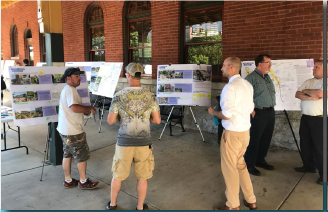
The steering committee met throughout the planning process with the consultant team, from analysis to final recommendations. Stakeholder interviews were held March 2016 to provide critical public input. The interviews allowed the design team to discuss recommendations of previous planning efforts and gain insight into the issues and opportunities in the study area. A public meeting was held on May 17, 2017 to solicit public feedback to assess the community support and interest for potential projects. The outcome of this effort aided in the prioritization of key projects. The Vision Plan is going to City Council for adoption in August 2017
Stakeholder Collaboration
Stakeholders provided invaluable insight into the issues and opportunities in the study area. The following stakeholders were interviewed: Debbie Lumpkins (High Point Arts Council); David Briggs (High Point Theatre); Connie Lineberry (Connie C. Lineberry & Associates); Tammy Nagem (High Point Market Authority); Dorothy Darr (Southwest Renewal Foundation); Teresa Loflin and Edith Brady (High Point Museum); Charlie Simmons (Property Owner); Barry Kitley (High Point University); Dr. John Turpin (High Point University School of Art and Design); Sarah Belle Tate (Connect High Point), High Point Chamber of Commerce; Megan Oglesby (Connect High Point); and Heidi Majors (YWCA).
 The input received from these interviews and the feedback from the public meeting helped inform the prioritization of projects identified in the Vision Plan.
Key Outcomes
The HPMPO used Transportation Visioning for Communities to develop the Multi-modal Vision Plan that outlined six priority projects and 12 stand-alone projects. Many of the projects evaluated weren't new, but were reimagined through the visioning and stakeholder processes. Others are fresh ideas adapting to current market conditions and developed with guiding principles tailored to meet the study area's needs. The projects below emerged as those with the high public support and alignment with the guiding principles:
- Pedestrianize Main Street
- Main Street Gateway Features
- Elm Street Upgrade
- String and Splinter Heritage Trail
- Railroad Esplanade
- Redevelopment Opportunities
Stand-alone projects were also called-out in the plan as they did not receive as much public support or could be completed as an element of a priority project. These included the following projects:
- Lighting Improvements
- Alley Upgrade
- Crosswalk Improvements + Sidewalk Extension
- Trailhead at Centennial Station Arts Center
- Makerspace
- Pocket Parks/Community Gardens
- Green Drive Upgrade
- One-Way Pair Conversion for MLK Drive and English Road
- Centennial Street Upgrade
- Lindsay Street Upgrade
- Leonard Avenue Upgrade
- Interim ROW Projects
These recommendations will provide greater connectivity to the High Point multi-modal facility for citizens within the HPMPO. They will also be incorporated into future Metropolitan Transportation Plans and help guide future development of the downtown area. The City is introducing a Downtown Land Use Area Plan and redeveloping a site within the study area for a minor-league baseball stadium, retail and residential units, a children's museum, event center, educational cinema, state-of-the-art playground, and park.
Lessons Learned
When HPMPO applied for the SHRP2 Grant, staff did not expect to be awarded funding due to the nature of this planning project. However, once HPMPO began the process and using the Transportation Visioning for Communities product, it became clear that it would be a valuable resource for this effort. Because there were so many previous planning efforts in the study area, the Transportation Visioning for Communities product seemed "tailor-made" to HPMPO's challenges.
Throughout the development of the Vision Plan staying on schedule was difficult. HPMPO tried to coordinate this plan with the development of the area for the multi-use stadium. However, because the planning efforts for the multi-use stadium were so slow to develop, delays were experienced in the development of the Vision Plan. HPMPO eventually had to move forward with the Vision Plan and incorporate planning efforts for the multi-use stadium later in the process.
In the end, HPMPO felt that they ended-up with a better vision given the fact that they could develop its recommendations for the area without the influence of an additional plan.
Next Steps
- The Vision Plan will be presented to the City's Prosperity and Livability Committee and, if favorably recommended, will be forwarded to City Council for adoption.
- The City of High Point Planning Department is moving forward with a Downtown Land Use Plan that utilizes the recommendations from the Vision Plan.
- High Point is currently in the process of developing a downtown multi-purpose stadium for baseball, soccer, and entertainment. Recommendations from the Vision Plan will be implemented as part of future development of the area.
- Priority projects will be incorporated into the MTIP to seek funding for implementation.
Connections to PlanWorks
The City of High Point requested that HPMPO apply for this SHRP2 Implementation Assistance Program grant. In the early stages, as mentioned above, the original plan was to work in tandem with the development plan for the new multi-purpose stadium and develop a transportation vision for the area. The goal was to complete one unifying vision for the area and build off the multiple plans and ideas from past studies. The problem initially was the location of the stadium had not been fully determined. There were three possible locations for the stadium, but no decision had been made on exactly which location would be selected. This decision on location was pushed back several times, in turn our study was delayed. Finally, HPMPO had to decide to proceed with the Visioning study without the location of the stadium being determined. This was a problem for High Point, due to the possibility of another study being done for the stadium after the completion of the Vision Plan. From the MPO's perspective, this was not a problem because they were creating a vision for the area surrounding the multi-modal transportation facility if the stadium was in that study area or not. Later in the process, the location was identified and is mentioned in our study. Due to the nature of this study and the potential development from the stadium construction in or adjacent to the Vision Plan study area we did not use PlanWorks for our project. In retrospect, the PlanWorks "Partner Collaboration" and "Stakeholder Collaboration" Assessments could have been a benefit to the development of the Vision Plan, but trying to determine how to implement that process with all of the other "moving parts" would have been extremely difficult. In the future, though, PlanWorks will benefit HPMPO in other areas of transportation planning, such as with the development and update of its Metropolitan Transportation Plan.
For More Information
Contacts
Greg VenableTransportation Planning Administrator
Transportation Department
HPMPO
336-883-3310
greg.venable@highpointnc.gov Reena Mathews
Research Implementation Specialist
Federal Highway Administration
202.366.2076
reena.mathews@dot.gov