
US Department of Transportation
FHWA PlanWorks: Better Planning, Better Projects
Corridor System Management Plan (Caltrans, California)
Overview
Project Overview
Corridor System Management Plans (CSMPs) are designed to focus transportation planning efforts on the effective and efficient use of all facilities within an urban corridor by promoting systematic management strategies that optimize the current freeway system. Corridors include a roadway connecting two points, as well as the major parallel arterials and modal systems that operate on or within the broader area.
The concept behind the development of CSMPs came from the desire to focus on the total transportation system and the recognition that the best or most needed projects were not always being selected and funded. Ideally, the CSMP will succeed where other selection processes have failed because the backbone of the CSMP stems from a core set of performance measurements that create a consistent basis from which to conduct the analysis and make decisions.
Caltrans’ goal is to use CSMPs to create comprehensive corridor management strategies that bring together the planning efforts of Caltrans’ headquarters and district staff, local Metropolitan Planning Organizations (MPOs), County Congestion Management agencies (CMAs), local jurisdictions, and the California Transportation Commission (CTC). Collectively, these transportation planning agencies would bring together their resources and data to evaluate a corridor based upon agreed upon performance measures. The performance measures would provide an analytical framework that would enable a consistent assessment of existing conditions and traffic projections within the corridor. The CSMPs would act as a guide for implementation of system management and performance measurement. Overall, the CSMPs would provide one unified concept for managing, operating, improving, and preserving a corridor across all modes and jurisdictions for highest productivity, mobility, reliability, accessibility, safety, and preservation outcomes. The process used in the development of the CSMP is summarized in Figure 1.
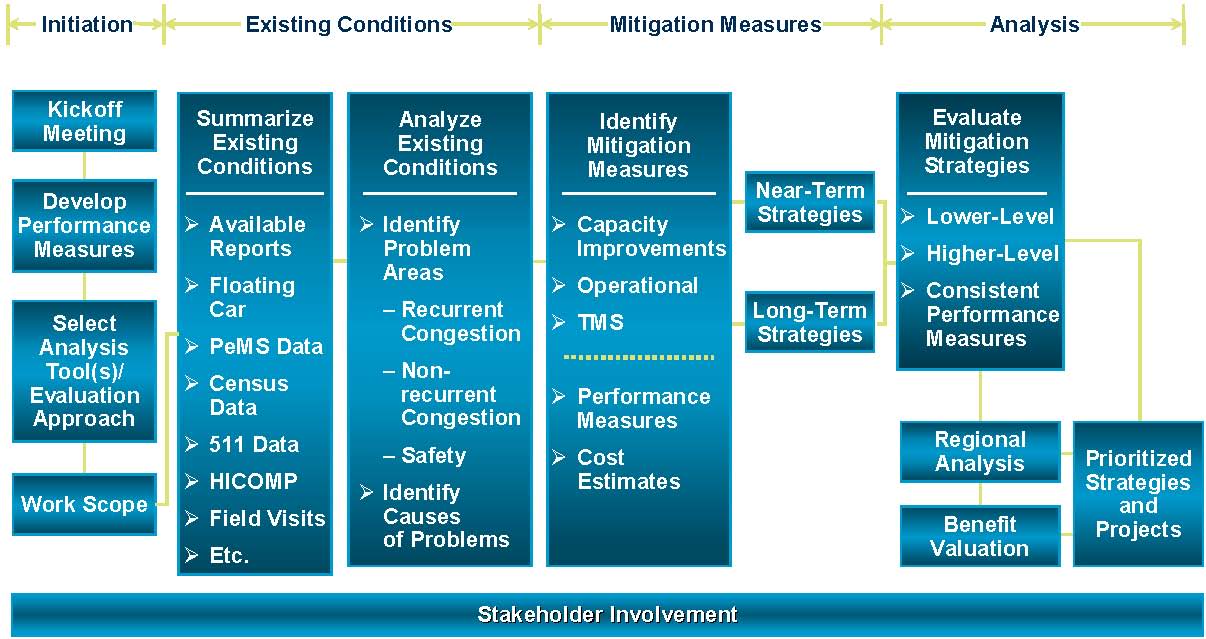
Figure 1: Overview of the Corridor System Management Plan Process
Source: Metropolitan Transportation Commission (MTC) Freeway Performance Initiative.
Screening Process Overview
The first CSMP undertaken by Caltrans was the I-880 Corridor in Alameda County, California; located in the San Francisco Bay Area. This corridor was selected based upon the extensive level of data available for this corridor and due to its high level of congestion. The Metropolitan Planning Commission (MTC) of the Bay Area, as well as the Alameda CMA and the local jurisdictions were heavily involved with both Caltrans Headquarters staff and District 4 staff in the development of the CSMP. Since this project has been successfully implemented, Caltrans has rolled out CSMPs to an additional twenty-six corridors throughout the state. However, the bulk of this case study summary of CSMPs in California centers on the experience in the I-880 Corridor in Alameda County.
The development of the CSMP for the I-880 Corridor focused on system management and all of its components. This is best represented in Figure 2, which is a pyramid that is part of the California Governor’s Strategic Growth Plan, GOCalifornia.
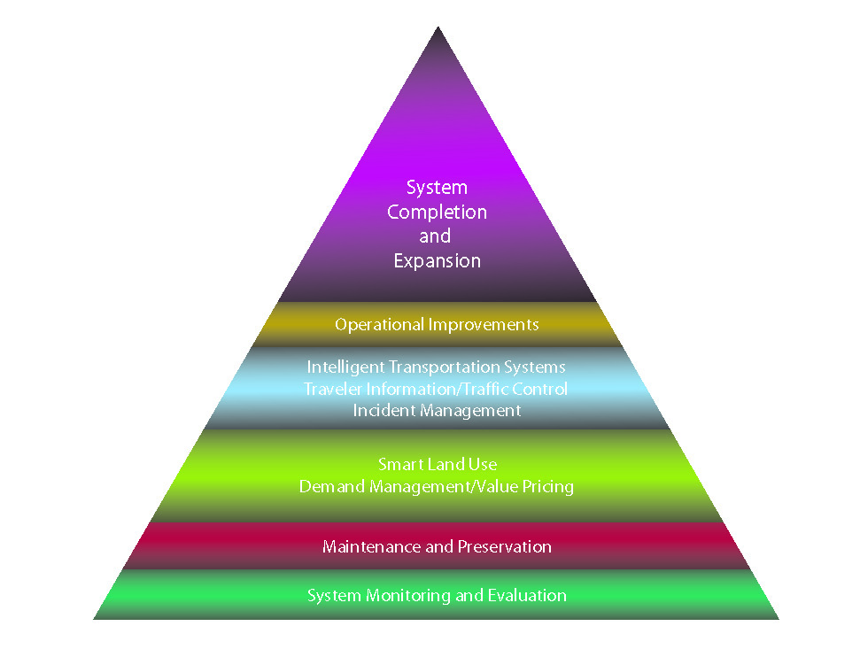
Figure 2: GOCalifornia Growth Plan
Source: Caltrans. Governor’s Strategic Growth Plan: GoCalifornia.
The development of the CSMP for the I-880 Corridor involved the following steps:
-
Study Initiation: An analysis team established communication channels, protocols, and data and information sources; discussed the scope of work, schedule, and budget; and obtained a thorough understanding of the goals for the study. This included defining the corridor limits and width and describing the corridor function.
-
Setting Performance Measures: The primary objective of the performance measures is to provide a sound technical basis for describing traffic performance on the corridor. In addition, agreeing not only on the performance measures, but source of the data; allowed the project team to make an evaluation of corridor performance with the same tools together. The project team used performance measures that were mostly developed by Caltrans Operations Staff over years of experience with other projects and analysis. However, the entire project team evaluated and decided upon which performance measures were relevant and needed for the I-880 Corridor.
-
Existing Conditions: The analysis team then collected and analyzed all information necessary to understand existing traffic conditions and to identify specific causes of problems. An inventory of the corridor was completed and included a description of the route type and current operational elements such as remote changeable message signs. Additionally, base data on traffic volume and type was gathered and included information on current annual average daily (AADT) traffic, peak hour AADT, 10 and 20 year AADT forecasts, and the number of 5 axle trucks.
The data was then analyzed using the performance measures to determine the current corridor performance. Measures evaluated included the current level of service, travel time and variability, and accident history. Recurring delays caused by signal controls and bottlenecks caused by change in route configuration were also described and quantified to the extent possible. Other factors that were documented and described are corridor operating procedures, signal control operations, and current maintenance and preservation practices (e.g., shoulder grading).
-
Future Corridor Performance: After establishing the base line information, ten and twenty year forecasted corridor performance was described. This included scenarios where the planned, programmed, and other improvements were made. This allowed the project team to evaluate each improvement/change and how the changes would reflect on the corridor performance measures.
In order to aid in the future assessment, micro-simulation models were used to forecast the future performance of the corridor. Micro-simulation was used to analyze traffic flows, provide a reasonable representation of queues and congestion, evaluate bottlenecks, analyze operational projects, and quantify benefits due to operational strategies.
-
Develop Mitigation Strategies and Projects: Once the data and performance measures had been reviewed, the project team was able to evaluate viable congestion relief measures, which were developed to maximize efficient use of the existing capacity within the corridor by using more traditional capital improvements. This included strategies to enhance the integration of the freeway with parallel arterials. The proposed measures were then segregated into short-term and long-term implementation timelines. The analysis team then identified strategies to mitigate congestion and began to develop planning-level cost estimates.
-
Analysis of Strategies and Projects: Finally, the analysis team evaluated the proposed congestion mitigation strategies and projects, making use of past and current evaluations of the corridor where appropriate, and conducting new analyses where needed. This helped the project team to bring the corridor to a higher facility standard as applicable and improve current operations.
Key Aspects of the Screening Process
Scope
The CSMPs are designed to be a part of the corridor planning phase. Based on the analysis and recommendations from the CSMP, the MTC will then use these recommendations as it develops and updates its TIP. The result is that the MTC will be able to put forward improvements for the corridor that will improve the overall corridor efficiency as outlined by CSMP process.
The initial CSMP for I-880 in Alameda County focused only on transportation performance based on the performance measures that were derived from traditional travel indicators, such as level of service. However, it is the goal of all parties involved to eventually integrate the CSMPs with other planning activities, such as land use and environmental resources.
The CSMP for I-880 resulted in the creation of strategies to enhance the integration of the freeway with parallel arterials and transit. The proposed strategies were then segregated into short-term and long-term implementation timelines. The CSMP was used to analyze and choose congestion management strategies and projects based on established performance measures.
Communications
Agency Involvement
The CSMP process is designed to be a collaborative process among all agencies involved with moving people and goods along a corridor. For the I-880 Corridor, the participating agencies included Caltrans Headquarters, Caltrans District #4, MTC, CMA, Bay Area Rapid Transit District (BART), and the local jurisdictions. Both Caltrans and the MTC led the CSMP process for the I 880 Corridor. They led the efforts of organizing and developing the project, scope, and framework. In addition, they brought all of the participants together to agree to and develop the CSMP process, as the collaboration of all the agencies was essential to its success. This came out of a series of steering committee meetings and policy development meetings. The CMA is in the process of completing the modeling aspects of the CSMP. The data used in the analysis process came from existing data sources that Caltrans, the MTC, and the CMA already had in place.
The participating members of the CSMP process were each required to sign a charter stating that they were committed to improving transportation along the corridor and working together to attain the benchmarks set based on the agreed upon performance measures. This step helped to formalize each organization’s commitment to making fundamental improvements to transportation along the corridor. The collaboration also facilitated the use of feedback from the participating organizations to help refine the study elements and address agency concerns as applicable.
Public Involvement
The CSMP process was designed to improve efficiency of a corridor based on performance measures. This cross-agency, data driven process is geared more for identifying problems and solutions at an administrative level prior to citizen-focused efforts that typically take place later during the transportation planning process. The public is not involved in the development of the CSMP, but will ultimately have a voice concerning the outcomes of the CSMP process as the results of the analysis will be presented to the public for discussion during the development of the TIP.
Technology
Three separate tools were utilized to calculate mobility: Probe Vehicles, PeMS, and 511. Data from the statewide Highway Congestion Monitoring Program (HICOMP) was able to provide valuable data sets for the I-880 Corridor. The HICOMP provides a comprehensive data report on congestion levels for heavily traveled freeways throughout California. The data is gathered through probe vehicles, which make trips over pre-determined segments and measure the time needed to complete a route. HICOMP also uses loop detectors to gather data for the comprehensive reports.
PeMS is a web-based tool designed by UC Berkeley to host, process, retrieve, and analyze road traffic condition information. PeMS receives data from California freeway traffic detectors, as well as incident-related data from the California Highway Patrol and Caltrans. This data is entered into some of the performance measures used in the CSMP process. This includes vehicle-miles-traveled and ADDT, from real-time and historic freeway detector data.
511 is a system that the MTC developed to give commuters access to real-time travel time information. This is meant to assist commuters with planning their trips around accidents and bottlenecks. Over the years, MTC has archived this data and it was able to be used to study historic travel patterns and issues along the I-880 Corridor.
Based on the data resources for the I-880 Corridor, performance measures were jointly developed by Caltrans and MTC, and taken to the local agencies for approval. A subregional model, or a model more designed to accommodate a smaller area, was originally developed by MTC, and then the Congestion Management Agency (CMA) was allowed to develop a consistent subregional model utilizing the same inputs and model structure. A micro-simulation model was developed with funds from the Caltrans District Office by a consultant. Micro-simulation models simulate the movement of individual vehicles, based on the dynamic variables of car-following and lane-changing. These tools were used to help identify deficiencies and highlight various alternatives. Additionally, cost benefit tools were utilized to help identify the most cost effective measures. The travel model outputs helped to show how different alternatives impact the performance measures.
Metrics and Data
The CSMP was developed based on a series of performance measures that focus on three key areas: mobility, reliability, and safety. The mobility performance measures are based on travel time and delay. The reliability performance measures capture the relative predictability of the public’s travel time and how much mobility varies from day to day. The safety performance measures are generally based on the number of accidents and accident rates.
The main sources of data for the performance measures were based on data obtained from PeMS, 511, and the Caltrans Traffic Accident Surveillance and Analysis System (TASAS). PeMS is a real-time system that automatically computes travel times using speed data from freeway indicators. 511 is also a real-time system operated by the MTC that obtains data by reading the time and location of Fastrak transponders at locations along the freeway. TASAS is a traffic records system containing an accident database linked to a highway database. These tools used to gather the metrics along the I-880 corridor were essential to the development of the CSMP. While some of these measurement tools are specific to California and the San Francisco Bay Region, the data they collect are commonly collected by state transportation departments and local MPOs through various means along heavily traveled corridors.
Lessons Learned
Success Factors
In its first implementation in Alameda County, the CSMP process was successful in getting all parties involved in transportation decision-making to work together on developing a plan for the I 880 corridor. This effort resulted in a signed commitment from each party to work collaboratively to implement changes that will help the corridor meet the agreed upon performance measures.
Key Innovations
Developing a set of performance measures that all participating agencies agreed upon was essential for creating a common baseline for measurement and decision making throughout the CSMP process.
Bringing together all agencies and jurisdictions involved with moving people along the corridor that not only considered the immediate highway, but the arterials and public transit within the corridor as well. This helped to ensure that the big picture would be considered in the decision making process.
Transportation improvement decisions were being made based on how the improvements are expected to impact corridor performance. This was based on the use of the performance measures and modeling techniques.
Barriers and Solutions
Analytical
The ability to complete the CSMP for the I-880 Corridor in Alameda County was dependant on a considerable amount of data from multiple sources. In the case of the I-880 Corridor, this level of data was already being collected by a combination of sources that included Caltrans, the MTC, and the CMA. However, different performance measures could be used to create a corridor plan relevant to the available data and situation at-hand.
The CSMP did not take into account impacts to the human or natural environment. Bringing this information into the analysis would provide a broader analysis of impacts. The issues that the project leaders faced with regards to addressing impacts to the human and natural environment included not being able to find a consistent data source and not being able to develop meaningful performance measures from the available data. Currently the MTC is working on identifying reliable data and beneficial performance measures that would strengthen the CSMP process.
Institutional
The CSMP process will only apply to large urban areas which have active traffic operations initiatives. Rural areas that have less traffic operations data would not be able to utilize the CSMP effectively. The proponents of the CSMP did not address attempting to make this a process which could be used by all areas regardless of size.
Due to the technical data components of the performance measures that the CSMP is based on; many of the local jurisdictions and elected officials had to go through a learning process to develop an understanding of traffic operations strategies and the effectiveness of traffic operations measures. This problem was circumvented by a series of workshops that Caltrans and the MTC provided that gave the requisite technical background for the participants to move forward.
Recommendations
The CSMP process is an excellent medium for bringing together the organizations responsible for making transportation decisions. The CSMP focuses the energy and efforts of these organizations and, with the agreed upon performance measures, creates a common decision making tool. The results and recommendations of the CSMP provide the decision-makers with the information required to make well-educated decisions regarding transportation funding.
Sources
California Center for Innovative Transportation. PeMS. http://www.calccit.org/projects/pems.html (accessed 10 September 2007).
Interim Instructions for Preparing Corridor Management Plans (CMP) Corridor Mobility Improvement Account Program (CMIA). Caltrans. No date.
MTC Freeway Performance Initiative - Traffic Analysis Performance and Analysis Framework DRAFT. Metropolitan Transportation Commission. No date.
Personal interview. Deputy Director of Operations of Caltrans. 22 August 2007.