
US Department of Transportation
FHWA PlanWorks: Better Planning, Better Projects
I-69 Trans Texas Corridor Study – Quantm Corridor Optimization (Texas Department of Transportation)
Overview
Project Overview
The National I-69 Corridor was established in the Intermodal Surface Transportation Efficiency Act of 1991 (ISTEA). In 1998, the Transportation Equity Act for the 21st Century (TEA-21) amended the I-69 Corridor to include Corridor 20, which included Laredo, the lower Rio Grande Valley, and Texarkana in Texas. As a result, 15 separate sections of independent utility (SIUs) for I-69 were located in Texas and an alignment-level National Environmental Policy Act (NEPA) evaluation was needed on each.
Many foresaw this substantial effort overwhelming the capacity of resource agencies to adequately participate in the review and decision making for these studies. In 2000, to address the overwhelming workload on agencies and to comply with Section 1309 of TEA-21 requiring FHWA to streamline the environmental process, the Texas Department of Transportation (TxDOT) and FHWA began a pilot environmental streamlining program with the I-69 NEPA studies. Partnering sessions began with federal and state agencies in February 2001. By the beginning of 2002, a preliminary process manual had been developed. This manual explained how the agencies would undertake the coordination and decision making for the associated alignment-level study for each of the 15 SIUs.
Shortly after the preliminary process manual was circulated for participating agency review, Texas Governor Rick Perry announced his vision for accommodating the Texas transportation needs of the future. The Trans-Texas Corridor (TTC) Plan was developed, which included multimodal corridors throughout Texas to help provide efficient and comprehensive movement of people, goods, and services. The I-69 Corridor was identified as one of the TTC Plan's high-priority corridors, and it was proposed that the Trans-Texas multimodal corridor be melded with the I-69 Corridor studies. The multimodal aspects of the TTC provided added complexity in the identification and evaluation of alignments. For example, the high-speed rail mode provided a more restrictive horizontal geometry for alignments that was seen initially by some agency representatives as overly burdensome to the roadway alignments being sought.
Because of these complexities, a tiered NEPA compliance process was proposed and ultimately accepted. The first tier of the process (Tier 1) selected preferred corridors for the various SIUs for the TTC. This single NEPA study and document was to be followed by subsequent alignment-level NEPA studies (Tier 2) for each SIU.
According to the process manual outlining the pilot program, "[t]he goal of the I-69/Trans-Texas project development and NEPA process is to facilitate timely, cost-effective, and functionally and environmentally sound transportation decisions. This framework will allow transportation decisions to be made, in collaboration with our partners and stakeholders, that meet the transportation purpose and need, minimize the negative impacts of the proposed action, and protect and enhance the natural and human environment" (1).
The screening process is explicitly described in the process manual, which prescribes specific concurrence points for agencies as well as when public involvement should occur. TxDOT and FHWA used this process, which was coordinated by the consultant program manager or general engineering consultant. Tier 1 corridor-level environmental impact statement (EIS) concurrence points are (1) purpose and need, evaluation criteria, and study area limits; (2) corridor alternatives; and (3) preferred corridor(s) alternative. Concurrence points during the Tier 2 alignment-level EIS are (1) (noted as point 4 in the process manual) NEPA and Section 404 purpose and need, SIU evaluation criteria, and SIU alignment alternatives; (2) (noted as point 5 in process manual) preferred alternative; and (3) (noted as point 6 in process manual) environmental mitigation. Figure 1 summarizes the overall pilot environmental streamlining process.
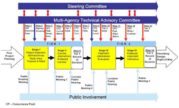
Figure 1. Summary of the overall pilot environmental streamlining process (1).
Figure 1 references two of the three main decision-making bodies for the project: the Steering Committee and the Technical Advisory Committee (TAC). The third and ultimate decision-making body is composed of the designated FHWA and TxDOT administrators.
The Steering Committee was composed of executive/policy-level staff of FHWA, TxDOT, and both federal and state regulatory agencies with decision-making authority within their respective agencies. This smaller decision-making body was developed to provide oversight, TAC decision approval, and TAC conflict resolution. The TAC was a larger working group involving TxDOT, FHWA, state and federal resource agencies, and metropolitan planning organizations (MPOs) affected by the project; it was developed to assess project issues and provide recommendations for decisions to the Steering Committee.
Screening Process Overview
Although there was a concern that the 15 concurrent studies would overwhelm the ability of the resource agencies to participate adequately, there were also other issues that led to the development of the pilot environmental streamlining process. Among these issues was the observed need for earlier and more substantive agency involvement in prior similar studies. Additionally, TxDOT and FHWA found that agencies either did not know or were inconsistent in the data they found necessary at various decision points. To correct this, the SIUs needed continuity in data and consistency in analysis. For this effort, a new paradigm was necessary.
The process manual, which outlined the coordination and decision-making protocol of the agency body, was augmented and integrated with a series of tools. The screening of alternative Tier 1 corridors began with the identification of alternative 1,000-ft-wide routes using the Quantm route optimization system, the principal tool used in developing alternative Tier 1 corridors. Note that the initial intended use of Quantm was to facilitate the identification and evaluation of alternative roadway alignments for each of the SIUs. However, the objective for Quantm following the melding of the I-69 and TTC studies changed to the identification of wider corridors for further detailed study in Tier 2. Key criteria used in Quantm to constrain the location of alternative corridors included wetlands, managed lands, population density, sites on the National Register of Historic Places and the Texas State Archaeological Landmarks larger than 23 acres, and Texas Ecological Assessment Protocol (TEAP) Composites 4 and 5 (discussed in the Technologysection of this case study).
After routes were identified and reviewed for reasonableness, team workshops were held to present and discuss these preliminary corridors. A Level 1a planning review was then conducted on alternative corridors to evaluate the effectiveness of each corridor in meeting the purposes for and needs of the project. Corridors were modified, added, and omitted from further consideration at this point.
Following this evaluation, corridors were subjectively grouped in a corridor consolidation step in which individual routes identified by Quantm were "clumped" together, indicating good common route segments. This grouping created corridors of different widths, ranging from 0.5 to 4 mi.
Following corridor consolidation, a Level 1b planning evaluation was conducted. The Level 1b analysis reviewed these consolidated corridors with respect to the effectiveness of the purpose and need. Again, corridors were modified, added, or omitted from consideration. Resulting corridors were then evaluated in greater detail. Environmental, engineering, and transportation evaluations were conducted on each of the preliminary corridors. TxDOT (Texas Turnpike Authority and Environmental Affairs Division representatives) and FHWA staff reviewed the assessments and made their recommendations. Recommended reasonable corridors were then carried forward to detailed evaluation and documentation in the Tier 1 EIS.
The application of the screening criteria and overall process was generally viewed as a success; however, because the Tier 1 EIS has not yet been distributed for comment, public and agency opinions are not yet known. Nevertheless, all key resource agencies agreed on the process. The procedures in the process manual were new to Texas. Although a NEPA/404 merger agreement is in place in Texas between FHWA and the U.S. Army Corps of Engineers (USACE), it is not commonly used. The process manual provided structure to the decision-making process through the establishment of the Steering Committee, TAC, and concurrence points.
Additionally, the method employed reasonable, defendable, well-documented, and reproducible procedures for the identification of preferred corridors across Texas that will meet the purposes of and needs for the project. Without such a well-structured process, each SIU would require joint SIU corridor- and alignment-level EISs. Such a process is potentially problematic because logical termini, study areas, and other coordination issues between adjoining SIUs may result in midproject revisions of alternatives, as well as other time delays. The new process, on the other hand, resulted in improved relationships among agencies and between TxDOT, FHWA, and the resource agencies. This is seen unanimously as the key benefit of the process.
Key Aspects of the Screening Process
Scope
The I-69 NEPA streamlining pilot project process was developed to identify and evaluate alternative corridors and ultimately to select the best corridor(s) for further study in subsequent TTC alignment-level NEPA documents. This process is completed in two steps or tiers. Tier 1 produces a single NEPA document that identifies the best corridor(s) for the Texas SIUs. Tier 2 produces alignment-level NEPA documents for each SIU. Although it is used in the NEPA context, this corridor screening method can and should be completed during the planning phase of a project before the NEPA/environmental clearance phase. The result of the process, especially because of the TAC's role, was that the project is "on the radar" of participating agencies. Because of this early coordination with agencies, ports, airports, MPOs, and other entities, future discussions and project work in the subsequent Tier 2 alignment-level analysis should be facilitated, which includes the evaluation of the multimodal corridors (i.e., 1,000-ft-wide alignments) envisioned in the TTC Plan, as well as other alternatives (e.g., no-action alternative).
Communications
Agency Involvement
The process was built around a decision-making framework that involved key federal and state agencies. Agencies included in the process as evidenced by their signature and acceptance of the process manual are FHWA, the Texas Commission on Environmental Quality (TCEQ), TxDOT, the Texas Parks and Wildlife Department (TPWD), the U.S. Environmental Protection Agency (EPA), the Texas Historical Commission, USACE, the U.S. Fish and Wildlife Service (USFWS), the U.S. Forest Service (USFS), the Louisiana Department of Transportation and Development, the Houston-Galveston Area Council MPO, the Victoria MPO, the Corpus Christi MPO, the Laredo Urban Transportation Study MPO, the Lower Rio Grande Valley Development Council MPO, the Brownsville MPO, and the Harlingen/San Benito MPO.
Key regulatory agencies were represented on the TAC. Their roles and responsibilities were clearly delineated in the process manual but were centered on obtaining consensus at various decision points in the project. These concurrence points are described in the Project Overview section above and in Figure 1. TAC decisions were made in accordance with the process manual, which describes the procedures for concurrence or nonconcurrence, revisiting decisions, documenting decisions, and making changes to the process. Conflict resolution procedures are also described in the process manual. Notably, all key resource agency decision makers approved the process manual for this project; therefore, they "bought into" the decision process. Key decisions were documented on specific forms developed for the process manual. According to procedure, the TAC would document a decision on Form A. They would then make a recommendation to the Steering Committee on Form B. The Steering Committee would document concurrence on Form C, and then make a recommendation to FHWA on Form D. Form E was used by FHWA to document a decision to proceed with the recommendation. All forms clearly note the concurrence item, the recommendation, and the name and signature of the agency decision maker.
Agency feedback at meetings was incorporated immediately into discussions and decision making. Agency comments received in written form were assessed and classified. If the information was relevant to Tier 1, it was taken into consideration during corridor development and evaluation. Comments related to subsequent Tier 2 alignment-level evaluation were retained and documented for future consideration. Comments were assigned to one of six topic areas:
- Request investigation of new corridor(s);
- Request refinement of recommended reasonable corridor(s);
- Request dismissal of recommended reasonable corridor(s) because of environmental and/or planning reasons;
- Identify new or previously unknown Tier 1 environmental and/or planning information that may influence corridor evaluation;
- Identify recommended reasonable corridor/link preference; and
- Other comments that would not affect the recommended reasonable corridor decisions to date (e.g., Tier 2 level of information and transportation policy issues).
Public Involvement
Public involvement was prescribed in the process manual and fully detailed in a public involvement plan. Public involvement was sought at the scoping stage and following the establishment of the purpose and need and preliminary corridor development, as well as after the draft EIS was circulated for public comment. Public involvement during Tier 2 is planned for the beginning of the alignment-level draft EIS, following the circulation of the draft EIS, and following the identification of the preferred alignment alternative and preceding the Record of Decision for the Tier 2 EIS. There have been numerous public meetings held all along the TTC SIUs. Public comments were assigned to the topic areas used for written agency comments described in the Agency Involvement section above.
Some comments were deferred to Tier 2; others were simple preferences. A minority of the comments were substantive, suggesting the addition, modification, or dismissal of corridors; such comments were evaluated further. MPOs also can be considered representatives of local concerns and were included in the TAC, which was involved in all decisions. Finally, in addition to the scheduled public meetings, small group meetings were held with local groups, MPOs, and others.
Larger, open-house-style meetings were the principal method used to involve the public. Newspaper ads, mail-outs, postcards, and newsletters were used to announce meetings and communicate project updates. Bilingual communication materials were needed. Three public involvement firms and an on-site public involvement manager were used to ensure a consistent message and that appropriate information and graphics were maintained and provided to TxDOT.
Technology
There were several technologies used during the course of this project. The most notable and heavily used are described below.
GIS Solution Screening Tool (GISST)
EPA Region 6 developed the Geographic Information System Screening Tool (GISST), which is a GIS-driven environmental assessment and data management tool for environmental streamlining that is shared with TxDOT (2). GISST was developed to provide a more systematic approach to considering single media and cumulative impacts in making environmentally sound decisions. It is designed to better understand the potential significance of single and cumulative effects and to facilitate communication of technical and regulatory data to the industry, the public, and other stakeholders. The scoring structure consists of criteria based on available data sets and expert input, using 1 as low concern and 5 as high concern (3). GISST uses ArcGIS to identify and map environmental concerns and to screen potential projects. Activities are under way to expand the GISST to better support NEPA transportation needs from planning and scoping phases to the final EIS and Record of Decision. EPA Region 6 and TxDOT have found the GISST to be an excellent tool for decreasing NEPA review time, while compensating for staffing limitations.
The project team used the GISST data extensively to help facilitate potential impact analyses during the planning process and improve environmental stewardship through avoidance and minimization during corridor identification, evaluation, and selection. The preliminary corridor environmental evaluation considered 21 GISST criteria (see Table 1, p. 00).
GISST scores were developed for each 1-km-square grid cell within the I-69/TTC study area. The extent to which a feature is present within a particular grid cell for each criterion was determined, and a score between 1 and 5 was assigned (3). For those criteria (2, 6, 10, 11, and 15) where the GISST score is 1 or 5, a 1 signifies the absence of that criterion and a 5 signifies the presence of the criterion.
Texas Ecological Assessment Protocol (TEAP)
TEAP is a planning- and screening-level assessment tool that uses existing data available from the statewide GIS grid to identify ecologically important resources throughout Texas (4). The results of the TEAP can be used in project planning (e.g., scoping, alternatives analysis), in determining appropriate areas to conduct detailed field investigations, and in mitigation discussions to avoid ecologically important areas, minimize impacts to those areas, and compensate for unavoidable impacts.
The potential intended uses of the results of the TEAP include the following: (1) in the NEPA planning process (e.g., scoping, alternatives development); (2) in streamlining the authorization process for large projects (e.g., transportation) by narrowing the study corridor necessary for further field investigation; and (3) in mitigation discussions to avoid ecologically important areas, minimize impacts to those areas, and compensate for unavoidable impacts. This list of intended uses is not exhaustive or all-inclusive. The TEAP is not designed to take the place of agency policies and procedures. It is a supplemental information tool aiding in agency decision making.
Similar to the way they used the GISST data and criteria, the project team used the TEAP data extensively to help facilitate potential impact analyses during the planning process and improve environmental stewardship through avoidance and minimization during corridor identification, evaluation, and selection. The TEAP data and criteria were included in the 21 GISST criteria referenced above and listed in Table 1 (p. 00). The TEAP data incorporate GISST wildlife habitat, federal and state threatened and endangered species, ecologically significant streams, sustainability, diversity, rarity, and an overall composite rating.
The Quantm analyses resulted in routes that passed through avoidance constraints. GISST and TEAP avoidance constraint data were used during this process by incrementally inactivating the avoidance constraints until Quantm could generate routes. Inactivating avoidance constraints allowed corridor development but left potential resource effects that might exist to be addressed during Tier 2, if the project advances.
Quantm System (Quantm)
The Quantm system is an alignment optimization technology and methodology that performs analyses to generate potential routes using a digital terrain model, engineering design criteria (e.g., cut/fill side slopes, maximum grades), and defined constraints. The constraint definitions included certain GISST data sets (population density, wetlands, managed lands, and TEAP composite), city boundaries, and airports. In addition, other constraints were used in specific locations.
Quantm generated potential routes that planners, environmental scientists, and engineers used to determine corridors. This was accomplished by plotting the representative results of millions of potential routes on maps, also containing geographical features and features that routes should avoid, or route constraints. The representative results were chosen from those alignments that successfully avoided the constraints. These were areas where groups of routes were concentrated in bandlike formations or grouped patterns indicating likely corridor locations.
Statewide Analysis Model (SAM)
TxDOT developed the Texas Statewide Analysis Model (SAM) to provide analysis and forecasting of passenger and commodity/freight movements in Texas. The SAM provides data and results at a level that is more aggregate than that typically accomplished within urban areas in travel demand models. The project team used the SAM for quantitative analysis at a conceptual level to measure operational efficiency based on routing and location efficiency of preliminary corridors.
The SAM is integrated with more than two dozen Texas urban area models, and provides consistent and accurate analysis of the following general types of projects:
- Forecasting accurate statewide traffic volumes by mode for passenger and freight;
- Forecasting mode shifts for passenger and freight;
- Analyzing state-level, multimodal alternatives for each mode that should be accurate enough to support analysis for project selection;
- Analyzing concurrent modal and multimodal network alternatives; and
- Analyzing the relative impacts of domestic and through traffic for passenger and freight at the statewide and the individual urban area levels.
ProjectSolve
The I-69/Trans-Texas streamlining process includes using ProjectSolve2, a private, secure Internet-based collaboration tool website. ProjectSolve2 is specifically designed to facilitate communication and project information review in a secure environment. It is used to facilitate the project deliverables review process. Once project deliverables are available for TAC and Steering Committee review and comment (at least 30 days before scheduled TAC meetings), they are posted on ProjectSolve2, and the TAC and Steering Committee members are notified. ProjectSolve2 website functions include:
- GIS data set transfer and collection;
- Deliberation over concurrence points through a message board;
- Concurrence documentation;
- Issues identification and tracking;
- Project contacts database;
- Significant meetings and public involvement events calendar;
- New information alerts; and
- Related web links.
Data
Overview of Data
Engineering design criteria, a digital terrain model, estimated unit costs, and environmental data were provided or collected in support of the project. This information was used to develop and evaluate preliminary corridors that could accommodate the I-69/TTC design concept.
Engineering and environmental constraints data included a background map containing the following:
- Lakes and reservoirs;
- Rivers;
- Creeks, streams, and tributaries, which are indicated by blue lines on U.S. Geological Survey (USGS) maps;
- USGS quadrangle maps;
- Primary and secondary highways;
- Places (cities, towns, colonias);
- Political boundaries (federal, state, county);
- Railroads;
- Airports (controlled and uncontrolled);
- I-69 National Corridor Boundary;
- Ports;
- TxDOT district boundaries;
- Landfills;
- Mines and quarries;
- Dams and locks;
- Major utilities (e.g., pipelines, electrical transmission lines);
- Aerial mosaic (used with large-scale mapping only);
- Managed lands;
- Forested areas;
- Churches, schools, and cemeteries;
- Historic and archaeological sites;
- Indian reservations and tribal lands;
- Active oil well fields;
- Municipal water supplies (wells or reservoirs); and
- Other constraints.
These files were available from USGS and other state and federal agencies. Where necessary, the files were modified to match the I-69/TTC established projection, style, and format.
The GISST data that EPA Region 6 supplied included source data from various state and federal agencies, including the TEAP data that the Texas Environmental Resource Stewards(TERS) compiled.
Engineering Data
Engineering design criteria that allowed all TTC transportation modes to operate together were required. These criteria included the following:
- Typical sections for all TTC modes (i.e., roadways, rails, and utilities);
- Horizontal and vertical geometry;
- Maximum allowable and sustained grades; and
- Side slopes.
Engineering input criteria were developed with close adherence to TxDOT standards and current industry practice. The following sources were referenced in developing the engineering input criteria:
- TxDOT Roadway Design Manual (February 2004);
- A Policy on Geometric Design of Highways and Streets (AASHTO, 2001);
- Quantm Integrator User Manual (Quantm Ltd., 2003);
- TxDOT's Statewide Average Low Bid Unit Price for Construction (TxDOT, October and December, 2004);
- Crossroads of the Americas: Trans-Texas Corridor Plan (TxDOT, June 2002);
- Federal Railroad Administration, Track Safety Standards (49 CFR Part 213); and
- Manual for Railway Engineering and Portfolio of Trackwork Plans (American Railway Engineering and Maintenance of Way Association, 2003).
An existing and planned transportation infrastructure inventory was compiled from various sources, including TxDOT, MPOs, cities, counties, and ports. This information was used to determine the appropriate interconnections between the I-69/TTC and existing and planned networks.
Digital Terrain Model
The digital terrain model was derived from the National Elevation Dataset retrieved from the USGS website. It was based on an approximately 33-yd (30-m) grid and uses metric units. Digital orthophotography was also obtained from the USGS website.
Environmental Data
The environmental analysis primarily relied on existing GIS and GISST data. The I-69/TTC GISST criteria included 21 data sets. Each data set is organized in a 0.62-mi (1-km) grid cell over the study area and each grid cell is given a score of 1 to 5. The GISST data included the TEAP data. This approach facilitated potential impact analyses during the planning process and improved environmental stewardship through avoidance and minimization during corridor identification, evaluation, and selection. The individual GISST categories, including TEAP, are listed in Table 1 (p. 00):
- Stream density;
- Total maximum daily load (TMDL as outlined in Clean Water Act [CWA] [303d]);
- Flood plain;
- Ozone non-attainment;
- Hazardous waste;
- Managed lands;
- Agricultural lands;
- Wetlands;
- Wildlife habitat;
- Federal threatened and endangered species;
- State threatened and endangered species;
- Percent minority;
- Percent economically stressed;
- Population density;
- Ecologically significant streams;
- Summary (represents an assessment of the total for GISST criteria 1 through 15);
- New Summary (represents an assessment of the total for GISST criteria 1 through 8, 12 to 14, and 17 to 20);
- TEAP sustainability;
- TEAP diversity;
- TEAP rarity; and
- TEAP composite.
The GISST and TEAP data were supplemented with other available data sets. TxDOT and FHWA reviewed and approved these additional data. The acquired data were modified as necessary to fit the project scale and format. Environmental fieldwork was limited during the Tier 1 EIS process. Additional field data collection was limited to that accomplished from public rights-of-way. All new data acquired and approved for use were added to the GIS database for developing and evaluating corridors.
The following data sets were avoidance constraints in Quantm runs:
- GISST managed lands;
- GISST wetlands 3, 4, and 5;
- TEAP composites 4 and 5;
- GISST population density 3, 4, and 5; and
- National Register of Historic Places (NRHP sites and State Archaelogical Landmarks SALs greater than 23 acres.
These five data sets used in Quantm were established through a collaborative process involving the TAC members and were considered to have the most effect on corridor development, while representing key avoidance resources such as Section 4(f) properties (managed lands), threatened and endangered species (TEAP 4 and 5), wetlands (GISST wetlands 3, 4, and 5), densely developed areas (population density), and historic sites (NRHP and SALs), also known as Section 106 properties. The 23-acre (1,000-ft by 1,000-ft; 9 hectares) threshold was selected because areas smaller than this were considered too small to present a substantive obstacle during any Tier 2 alignment development processes.
In addition, city boundaries and airports were included in the list of avoidance constraints used in the Quantm analyses.
Aerial Photography
Aerial photographs were used to examine existing features. The 1995 and 1996, 1.09-yd (1-m) resolution, color infrared, digital orthophotos in Universal Transverse Mercator projection were used for all SIUs except SIU 4. These data were available in MrSid compressed format from the Texas Natural Resource Information System Digital Data Delivery system.
The Houston-Galveston Area Council provided 2004 aerial photography near Houston at 1-ft (30.48-cm) resolution. This aerial photography was used to provide current development information in the high-growth Houston metropolitan area.
Additional Data and Data Sources
Cultural Resources
The Texas Historic Commission's databases were searched to determine known NRHP and Texas SAL sites 23 acres (9 hectares) and larger. Potentially eligible sites and sites smaller than 23 acres will be determined during the Tier 2 alignment and mode-specific environmental and project development processes.
Oil and Gas Wells
The Texas Railroad Commission provided a GIS database containing oil and gas wells. This database contains surface and bottom hole locations of oil and gas wells or wells associated with oil and gas production and exploration.
Pipelines
The U.S. Department of Transportation, Texas Railroad Commission, and Texas General Land Office provided data containing pipelines throughout the project area. These data are stored in a GIS system.
Local Transportation and/or Comprehensive Plans
MPOs and local area governments were contacted to obtain local or regional planning documents.
Preliminary Corridor Evaluation Process (Metrics)
This section presents the evaluation of preliminary corridors and the identification of recommended reasonable corridors for public review. An overview of the evaluation process is presented in the section below. The preliminary corridor evaluation process employed a standard evaluation method which is described in Appendix B of the Tier 1 Corridor Alternatives Evaluation Report (CAER) (5).
The preliminary corridor evaluation and recommended reasonable corridor identification process included the following steps:
-
Step 1: Preliminary corridor evaluation results
- Environmental evaluation
- Engineering evaluation
- Transportation planning evaluation
-
Step 2: Assessment
- Environmental and engineering recommendations
- Transportation planning recommendations
- Coordination with MPOs and TxDOT district engineers
-
Step 3: Conclusions
- Joint reasonable corridor workshops
- Recommended reasonable corridors
Once the evaluation sections were determined and corridors named, the environmental, engineering, and transportation planning evaluations began. These evaluations were conducted concurrently. The three steps are explained in further detail in the remainder of this section.
Step 1: Preliminary Corridor Evaluation Results
Environmental Evaluation
The preliminary corridor environmental evaluation considered the 21 GISST criteria, as well as other secondary source data and information such as aerial photography and resource management plans. Table 1 presents the GISST criteria and the scores assigned to each criterion (5) (for the GISST criteria definitions, refer to Appendix C in the Tier 1 CAER).
Table 1: I-69/TTC GISST and TEAP Criteria and Scores
| GISST Criteria | GISST Scores |
|---|---|
1. Stream Density |
1, 2, 3, 4 and 5 |
2. Total Maximum Daily Load [(TMDL)/CWA 303d] |
1 or 5 |
3. Flood Plain |
1, 2, 3, 4 and 5a |
4. Ozone Non-Attainment |
1, 3 and 5c |
5. Hazardous Waste |
1, 2, 3, 4 and 5 |
6. Managed Lands |
1 or 5 |
7. Agricultural Lands |
1, 2, 3, 4 and 5 |
8. Wetlands |
1, 2, 3, 4 and 5 |
9. Wildlife Habitat |
1, 2, 3, 4 and 5 |
10. Federal Threatened and Endangered Species |
1 or 5 |
11. State Threatened and Endangered Species |
1 or 5 |
12. Percent Minority Population |
1, 2, 3, 4 and 5 |
13. Percent Economically Stressed Population |
1, 2, 3, 4 and 5 |
14. Population Density |
1, 2, 3, 4 and 5 |
15. Ecologically Significant Streams |
1 or 5 |
16. Summaryc |
1, 2, 3, 4 and 5 |
17. TEAP Sustainability |
1, 2, 3, 4 and 5 |
18. TEAP Diversity |
1, 2, 3, 4 and 5 |
19. TEAP Rarity |
1, 2, 3, 4 and 5 |
20. TEAP Composite |
1, 2, 3, 4 and 5 |
21. New Summaryd |
1, 2, 3, 4 and 5 |
a Occasionally there was a lack of data within a particular area.
b1 represents an attainment area, 2 represents a near nonattainment, and 5 represents nonattainment.
c This category represents an assessment of the total for GISST criteria 1 through 15.
d This category represents an assessment of the total for GISST criteria 1 through 8, 12 to 14, and 17 to 20.
Criterion 16 (GISST summary) represents an assessment of the total for the GISST Criteria 1 through 15. Criterion 21 (GISST new summary) represents an assessment of the total for the GISST Criteria 1 to 8, 12 to 14, and 17 to 20. The TEAP data incorporate GISST wildlife habitat (Criterion 9), federal and state threatened and endangered species (Criteria 10 and 11), and ecologically significant streams (Criterion 15).
The corridor evaluation utilized a GIS-based application to calculate the area coverage of each criterion as a percentage of the total corridor area. For comparison purposes, the area coverage percentage of the criterion throughout the SIU was also calculated. For non-GISST data, a similar area-based percentage calculation was performed. For example, the number of active oil wells per thousand acres for each corridor was based on counting oil well point data within the corridor (or evaluation section).
The GIS analysis estimated the area occupied by each criterion for each GISST score level, as appropriate. The calculated areas served as indicators to assess the potential for encountering and/or avoiding particular resources and features within a corridor. These calculations also provided the basis for comparing individual preliminary corridors within an evaluation section through application of a nonnumeric value rating system. This system represents an interpretive assessment of the type and coverage of resources and features contained within a particular preliminary corridor.
A specific rating methodology was used to assign nonnumeric values of excellent (E), good (G), acceptable (A), poor (P), or unacceptable (U), commonly referred to as EGAPU. These values were assigned for every GISST and non-GISST criterion used in the environmental evaluation.
The assignment of EGAPU values considered the percentages of each GISST score level as well as other factors unique to the evaluation section, such as aerial photography and other secondary source data. The following example demonstrates how the EGAPU values were derived.
Using GISST wetlands as an example, a preliminary corridor might include the following:
- 92% GISST wetlands 1;
- 5% GISST wetlands 2;
- 1% GISST wetlands 3;
- No GISST wetlands 4; and
- 2% GISST wetlands 5.
The small percentages of higher GISST wetlands scores (3% of GISST wetlands 3, 4, and 5) would indicate that the preliminary corridor would have less potential to affect wetlands. As such, the initial assessment could result in an E or a G value.
The EGAPU values assigned in one evaluation section cannot be compared with values assigned in other evaluation sections because of the unique characteristics contained in each evaluation section. For any given evaluation section, different criterion area thresholds may be used to assign EGAPU values. For example, in one evaluation section where GISST wetlands are 20% of the total area, a corridor containing 10% GISST wetlands may be assigned a value E or G. In another evaluation section, where GISST wetlands are 5% of the total area, a corridor containing 10% wetlands may be assigned a value of P or U.
In addition to the natural resource factors, social and economic factors were considered. These included GISST percent minority, GISST percent economically stressed, and GISST population density. The GISST percent minority and percent economically stressed criteria relate to identifying environmental justice (EJ) populations. If the corridor contained higher GISST scores for these EJ indicators, but had a low population density, GISST percent minority and percent economically stressed criteria were not necessarily differentiating factors used in identifying recommended reasonable corridors.
Engineering Evaluation
The engineering evaluation included consideration of a relative construction cost factor, centerline length, and connectivity with adjacent evaluation sections and/or SIUs.
Actual construction costs are currently unknown because specific alignments and designs have not been developed for the Tier 1 analysis. A relative construction cost factor was used to compare preliminary corridors, since a representative construction cost for each corridor was determined by using a typical cross section in conjunction with specific terrain models for each corridor. The typical cross section included all I-69/TTC highway and rail modes. The relative construction cost factor for preliminary corridors within each evaluation section was then calculated by dividing the representative construction cost for each corridor by the representative construction cost for the least expensive corridor and multiplying by 100.
Centerline length was calculated to compare the directness or circuitousness of the preliminary corridors within an evaluation section. It was assumed that a more direct corridor would more effectively achieve the purpose of and need for the project.
Also, it was necessary to coordinate between adjacent evaluation sections and SIUs to maintain corridor connectivity. The goal was to find the best combination of preliminary corridors that maintained connectivity and performed well from environmental, engineering, and transportation planning perspectives.
Transportation Planning Evaluation
A review was conducted to evaluate corridor performance using quantitative and qualitative tests that addressed the transportation planning goals and objectives, which are described in Appendix E of the Tier 1 CAER (5). Base evaluation data were generated by the SAM, the Texas travel demand forecasting model, supplemented by state and regional transportation plans, USGS land use mapping, and local planning objectives addressing I-69/TTC provided by the MPOs in Texas and Louisiana, plus the TxDOT district engineers, within the I-69/TTC study area. These data supported the quantitative and qualitative tests for measuring preliminary corridor performance in Texas and Louisiana.
Quantitative Transportation Planning Analysis (Benefit Index)
The quantitative transportation planning analysis, or benefit index approach, assessed the location advantage of each preliminary corridor in routing long-distance travel and in servicing local travel within the study area. The analysis compared the travel distances, travel times, and resulting user and vehicle operating and maintenance costs. These factors were calculated using SAM-generated auto and truck traffic volumes assigned to a generic I-69/TTC corridor generally located along the center of the I-69/TTC study area and connector highways serving urban areas, industrial zones, and other traffic generators.
This method provided a practical approach for generating representative preliminary corridor traffic volumes at a broad Tier 1 analysis level. The traffic volume assignments provided the basis for estimating vehicle miles traveled (VMT) and vehicle hours traveled (VHT). VMT and VHT data were converted to travel distances and travel times from which user and vehicle costs were calculated for each preliminary corridor.
Travel distance and cost factors calculated for each preliminary corridor were combined into a single benefit index. The benefit index is a quantitative index for gauging the overall location advantages of the preliminary corridors for improving accessibility, connectivity, mobility, and operational efficiency relative to the primary existing highway route used for long-distance travel within the I-69/TTC study area.
The existing primary routes, including US-59, US-281, and US-77, were assigned a 1.00 benefit index, which served as a benchmark for comparing preliminary corridor performance. For example, a 1.20 benefit index indicated that the preliminary corridor reduced costs and improved user benefits by 20% compared with the existing primary routes. The benefit index is a preliminary performance indicator for identifying recommended reasonable corridors and should not be used to compare the estimated economic value of the new location corridor alternatives with the no-action alternatives.
Qualitative Transportation Planning Assessment (Qualitative Index)
The qualitative assessment evaluated preliminary corridor performance for achieving I-69/TTC purpose-and-need transportation planning goals and objectives not addressed through the quantitative analysis. Series of qualitative tests were performed to evaluate the compatibility of the preliminary corridors with
- Existing and future transportation infrastructure;
- Statewide, regional, and local land use plans; and
- Transportation plans and local planning objectives (5).
The base data for the qualitative assessment included Texas and Louisiana population and employment projections, USGS land use mapping, and SAM inventoried existing and planned roadway and rail infrastructure and rail tonnage estimates. In addition, interviews were conducted with Texas and Louisiana MPOs, as well as TxDOT district engineers, within the I-69/TTC study area to determine local planning objectives. The base data were mapped and compared with the routing of the preliminary corridors. Typically, each preliminary corridor was rated favorable (+2 or +1), neutral (0), or unfavorable ( '1 or '2) for each qualitative test (5). Cumulative scores for each preliminary corridor were calculated to determine an overall qualitative index, expressing corridor compatibility with existing and planned land use, transportation infrastructure, and ability to serve traffic generation.
Additionally, the need to retain redundant corridors for flexibility in constricted areas, such as river crossings where corridor widths narrowed to avoid environmental constraints, was evaluated. Redundancy was recommended in these constricted areas so that a corridor could be developed were a particular corridor to be constrained by engineering or environmental features.
The benefit and qualitative indices for each preliminary corridor were compared within each evaluation section. At times, if the two ratings conflicted, and the qualitative differences were sufficiently compelling to carry greater weight, the qualitative index score superseded the benefit index score. A system analysis for long-distance trips then combined individual evaluation-section corridors into systemwide corridor options. The benefit index and the qualitative index for the evaluation-section corridors comprising each system corridor option were considered when making recommendations.
Assessment
An assessment of the evaluation results was conducted to determine the environmental, engineering, and transportation planning advantages and disadvantages of the preliminary corridors. The advantages and disadvantages were based on differentiating factors unique to the corridors in each evaluation section. For the environmental and engineering assessments, differentiating factors were defined as those resources that exhibited a variation of EGAPU scores for corridors within an evaluation section. Where individual EGAPU scores were the same for a particular resource within an evaluation section, that resource was not carried forward as differentiating.
Corridor recommendations were not made solely on the identified differentiating factors. The assessment further investigated the distribution, density, and overlap of individual resources to determine which of the resources were key to the decision-making process in the evaluation section. These key resources were then defined as distinguishing for influencing corridor recommendations.
The intent of the assessment was to determine which preliminary corridors best met the project purpose and need and avoided or minimized the potential effects.
Environmental and Engineering Recommendations
After comparing the advantages and disadvantages of the preliminary corridors, a recommendation to advance or dismiss corridors in each evaluation section was made from a combined environmental and engineering perspective.
Transportation Planning Recommendations
A separate recommendation to advance or dismiss corridors in each evaluation section was made from a transportation planning perspective. The planning recommendation took into consideration the goals and measures (5), as well as the results of the quantitative and qualitative analyses.
Coordination with MPOs and TxDOT Districts
In conjunction with the environmental, engineering, and transportation planning recommendations, briefings were conducted with the TxDOT districts and with MPOs within the I-69/TTC study area to obtain their input on the preliminary corridors. The information gathered during these briefings was considered during the reasonable corridor workshops.
Conclusions
Joint Reasonable Corridor Workshops
The environmental, engineering, and transportation planning recommendations, along with input from the MPOs and TxDOT districts, were presented and discussed at workshops held for each SIU. The purpose of the workshops was to obtain TxDOT and FHWA concurrence on the recommended reasonable corridors that would be presented to the public. The results of these workshops are documented in the meeting minutes for each individual SIU.
Recommended Reasonable Corridors
Following the workshops, the recommended reasonable corridors were reviewed by TxDOT district personnel. TxDOT also briefed EPA, USACE, USFWS, USFS, TPWD, and TCEQ on the results of the workshops before the July and August 2005 public meetings.
Lessons Learned
Success Factors
At the time of this writing, it was too early in the process to determine its success (the draft EIS was scheduled to be released to public in November 2007). However, some lessons were learned from internal team assessment.
NEPA Tiering Is Uncommon and Difficult for Some Agencies and the Public to Accept
The use of a more complicated or less common method of analysis (i.e., NEPA tiering instead of a single NEPA document) requires education of both the agencies and the public. For instance, agencies that review EISs for site-specific detail did not initially understand the more general nature of the corridor-level EIS, and the public wanted to know where and when the road would be built. The Tier 1 EIS results will not provide this answer. The concept of doing a detailed evaluation to result in an "area" rather than an "alignment" or "footprint" is not as understandable or satisfying to the public and some agency representatives. Some on the team believe that the addition of tiering to the process manual was a mistake in that it made the process more complicated. Additionally, with the use of tiering, the likelihood of more than several concurrent alignment-level EISs is low, which undermines the reason (i.e., streamlining agency review of 15 SIUs) for creating the process manual.
Small Agency Meetings Are More Effective Than Larger Committees or Group Agency Meetings
The development of the TAC also yielded several lessons. The larger group of the TAC was not as effective at satisfying agency concerns. Individual meetings held with agencies were seen as more effective than the larger group meetings. The vertical decision structure (i.e., TAC, Steering Committee, and FHWA approval) took time to implement and was seen as cumbersome to most.
The Consultant Contracting Method Used Has Critical Consequences
The contracting method used for the project was seen as cumbersome given the corridor level of evaluation. Separate SIU consultants were selected initially to do alignment-level EISs for each SIU. Once the TTC component was merged with the I-69 study in 2002, the evaluation changed to the identification of a corridor that satisfied all needs (i.e., I-69, freight and high-speed passenger rail, truck route, and utilities). The contracting structure, however, remained unchanged. The use of a single contractor to evaluate corridors rather than multiple consultants would have (1) reduced the complexity of the Quantm route identification and (2) improved the consistency of the subsequent corridor evaluation.
Use Actual Data When Available to Compare Alternatives
The EGAPU rating method was seen by all team members interviewed as problematic. After preliminary corridors were identified for further study, the corridor evaluation was conducted using the nonnumeric EGAPU rating system. The purpose of using these ratings was to accommodate the relative importance and unimportance of the different environmental issues evaluated in different regional contexts and to allow the comparison of corridors by providing a common rating system. Each of the SIU consultants used the EGAPU rating method, which resulted in varying subjective ratings regardless of the development and distribution of the standard operating procedure (SOP) SE08-H, "I-69/Trans-Texas Corridor Tier 1 Environmental Impact Statement (EIS) Corridor Development Analysis Process" (6). This SOP was distributed to all SIU consultants and enforced; however, the SOP only required the section engineer (i.e., the SIU consultant) to document the justification of his or her ratings. The numerous standards that would have to be developed for different regions precluded such standards documentation. The consensus of the team is that the EGAPU ratings were problematic because they were employed by numerous entities. It was suggested that actual values may more consistently and accurately evaluate these corridors, with professional judgment as a supplemental resource used to rank corridors on the basis of actual values and knowledge of the region.
Key Innovations
Combining Technology, Key Data, Agency Coordination, and Process Protocol into a Well-Documented and Reproducible Decision-Making Process
The whole screening process used for the I-69/TTC EIS is far greater than the sum of its parts. Although only a few of the processes or tools employed for this project are unique or even new, the way that these elements (i.e., agency involvement with key concurrence points, use of Quantm with GIST and TEAP data, and the Level 1a and 1b quantitative and qualitative analyses) were cohesively mated to each other is both unique and innovative. The tremendous task of evaluating more than 1,000 miles of new-location roadway alignment within 15 SIUs in an efficient, consistent manner required a new paradigm that differed from the traditional method of performing separate and independent evaluations on each SIU.
Use of NEPA Tiering for Long-Distance Highway Location Studies
The foundation of this new paradigm was NEPA tiering the preparation of a NEPA document that evaluates the more general or broader project issues prior to evaluating more detailed issues in subsequent NEPA documents that are tiered from and linked to the general issues NEPA document. The tiering options of the NEPA regulations are traditionally used for projects and programs related to identifying and choosing a preferred technology, method, and so forth before evaluating site-specific issues in subsequent tiered NEPA documents. Tiering in NEPA documentation is not commonly employed and, before the I-69/TTC EIS, had never been used by TxDOT.
Use of GISST and TEAP Data Sets and the Quantm Route Optimization Engine
The team's use of the GISST and TEAP data sets was yet another innovative strategy. The data sets provide an innovative way to assess corridors with more "coarse-grained" yet adequate data sets (compared with more "fine-grained" field and geographic data used in alignment-level NEPA documents). Finally, the use of the Quantm route optimization engine to identify wide corridors for more detailed, subsequent study is likewise innovative. Quantm was developed to identify alternative roadway alignments and to estimate their costs quickly. The use of this tool to help identify only corridors (as opposed to specific roadway alignments) is an atypical application of this technology. However, its use provided a consistent corridor identification method among all SIUs in Texas.
Barriers and Solutions
The barriers and solutions that were either encountered in this project or that the project was designed to overcome are summarized in Table 2.
Barriers and Solutions Associated with the I 69 Trans-Texas Corridor Project
| Type of Barrier | Barrier | Effect of Barrier | Solution | Effect of Solution |
|---|---|---|---|---|
Institutional |
Lead agency and resource agencies do not have a collaborative working relationship |
The process will not work |
Develop a process for collaboration and decision making prior to initiating the project |
Better likelihood of achieving agreement at key decision points |
Analytical |
GISST is a screening-level tool only |
It can only point the user in the direction of where problems are likely to happen |
Conduct further risk assessment and field investigation to validate results and identify need for additional studies |
More comprehensive and credible screening solution |
Institutional |
Stagnation ("We've done it this way for 20 years. Why change?") |
Staff and other stakeholders did not embrace the new screening methodologies and technology |
Seek management support and identify an evangelist who can meet with the staff and stakeholder opposition to help bridge the gap |
Establishes a more personal work relationship and can help build confidence in solution |
Institutional |
Regulatory and cultural differences among agencies |
Some agencies were open to innovative ways to collaborate, and others were opposed to any collaboration outside the norm |
Develop a collaborative decision-making framework that will establish guidelines and best practices for cross-agency collaboration |
Better collaboration and understanding of mutual goals and objectives between agencies |
Technical |
GIS analysis results produce large quantities of data |
There is too much information to process |
Develop selection criteria that will allow for subsets of the analysis results to be filtered and evaluated further |
More efficient and better evaluation measures |
Technical |
Reliance on quality and accurate data |
Without quality and highly accurate data the analytical results may be questionable |
Ensure data collection and quality assurance (QA) are factored into the project planning and budgeting so that quality and accurate data can be obtained and constantly updated |
Better quality and accuracy of data if the proper funding and attention are given early on |
Analytical |
Compliance with Safe, Accountable, Flexible, Efficient Transportation Equity Act: A Legacy for Users (SAFETEA-LU) |
SAFETEA-LU requires agency involvement; the goal is to keep agencies aware of long-range plans so that they will know when changes are forthcoming; limits their actual participation |
Involve agencies earlier and develop a process that defines all guidelines and compliance issues |
Better decisions, consensus building, and improved project success |
Institutional |
Multilingual population |
Not communicating effectively with all members of the population |
Develop a communication strategy and materials that ensure that all members of the population can be reached. |
Ensure that the public is aware of the opportunities for public involvement and that the public can gain access to information in their native language |
Institutional |
International border issues |
Challenges coordinating efforts that may have international influence or interests |
NA |
NA |
Institutional |
Inconsistent processes |
Lack of communication and collaborative decision making |
The process implemented was designed to overcome this barrier |
Expedited review and open collaboration; continuity in data and consistency in analysis among SIUs |
Institutional |
Political barriers |
Higher-level government can change rules in the middle of the process |
Develop a well-documented process with public involvement |
More comprehensive and credible screening solution |
Analytical |
Modal alternatives |
Freight and rail issues may conflict |
NA |
NA |
Institutional |
Funding across different agencies |
Collaboration is difficult when funding cannot be used across agencies to support joint work efforts |
Develop processes and funding vehicles in support of the efforts of multidisciplinary teams and agencies |
Improved work output among agencies and reduction of duplicative work efforts |
Analytical |
Missing data |
Data coverage did not include access point to Louisiana |
Acquire the necessary data sets to perform analysis |
Analysis was performed successfully |
Analytical |
Urban vs. Rural |
Urban transportation planning and assessment are different from rural issues |
Develop a flexible process that can accommodate the varying aspects of rural versus urban criteria |
Better-quality results that match the environmental or regional characteristics |
Institutional |
I-69 and TTC combined |
New objectives that included multiple modes of transportation |
Develop a process and tools that accommodate the assessment of multiple modes |
NA |
Recommendations
The project team has indicated that the process would be fairly easy to transfer to another agency. It is a well-documented process that could be leveraged by other states. It is also believed that some of the tools implemented could be extremely valuable in other states or regions. It is difficult to gauge the cost implications for other states to fully take advantage of the tools because of the great dependency on quality and accurate data. Texas was in a unique position in that most of the technology was available through previous efforts. The project was very complex, large scale, and well documented in the process manual. In particular, the GISST and TEAP tools should be evaluated by other states, because these tools and documentation offer great benefits if they can be reused.
References
1. I-69 Trans-Texas Corridor NEPA and Project Development Process Manual. Texas Department of Transportation, Austin, and Federal Highway Administration, U.S. Department of Transportation, September 2003.
2. Osowski, S. L., G. D. Carney, J. D. Swick, J. A. Danielson, D. A. Parrish, and D. Lueckenhoff. US EPA Region 6 GIS Screening Tool (GISST) User's Manual, Version 1.1. U.S. Environmental Protection Agency Region 6, Dallas, Tex., November 2005. www.epa.gov/earth2r6/6en/xp/enxp2a3a.htm. Accessed Aug. 9, 2010.
3. Osowski, S. L., J. D. Swick, G. R. Carney, H. B. Pena, J. E. Danielson, and D. A. Parrish. A Watershed-Based Cumulative Risk Impact Analysis: Environmental Vulnerability and Impact Criteria. Environmental Monitoring and Assessment, Vol. 66, No. 2, 2001, pp. 159-185. www.springerlink.com/content/u56426j847422w48. Accessed Aug. 9, 2010.
4. Osowski, S. L., J. Danielson, S. Schwelling, D. German, S. Gilbert, D. Lueckenhoff, D. Parrish, A. K. Ludeke, and J. Bergan. Texas Environmental Resource Stewards (TERS): Texas Ecological Assessment Protocol (TEAP) Results, Pilot Project. U.S. Environmental Protection Agency Region 6, Dallas, Tex.; Texas Parks and Wildlife Department, Austin; and The Nature Conservancy, Arlington, Va., March 2005. http://www.epa.gov/region6/6en/xp/teap_final/teap_full_report.pdf. Accessed Aug. 9, 2010.
5. I-69/Trans-Texas Corridor Alternatives Evaluation Report. Texas Department of Transportation, Austin, May 2006.
6. I-69/Trans-Texas Corridor Tier One Draft Environmental Impact Statement. Texas Department of Transportation, Austin, and U.S. Department of Transportation, Federal Highway Administration, November 2007. www.txdot.gov/txdot_library/publications/ttc.htm#i_69. Accessed Aug. 9, 2010.