
US Department of Transportation
FHWA PlanWorks: Better Planning, Better Projects
Binghamton Metropolitan Transportation Study
Scenario Planning Yields Community Vision
of Revitalized Urban Centers
Executive Summary
Transportation Tomorrow 2030: Placemaking for Prosperity is the long-range transportation plan of the Binghamton Metropolitan Transportation Study (BMTS), the metropolitan planning organization (MPO) for the greater Binghamton area of New York. Adopted in September 2005, the plan was one of the first in the nation to implement Federal Highway Administration (FHWA) recommendations calling for the use of visioning and scenario evaluation strategies during development of transportation plans. It was also perhaps the first application of scenario planning to a metropolitan area experiencing population loss.
The planning process featured a Community Vision Team that included business leaders, economic development professionals, university representatives, health-care organizations, arts advocates, and others. The planning process included a series of public workshops and technical analyses that culminated in consideration of two main scenarios: (1) continuing the current trend of population migration to the suburbs and "hollowing" of the area? urban cores, or (2) directing future economic and population growth toward the existing downtown areas of Binghamton, Johnson City, and Endicott. The Community Vision Team agreed that the latter scenario more closely matched their long-term vision for greater Binghamton.
This preferred scenario was formally endorsed by the BMTS Policy Committee and became the foundation for Transportation Tomorrow: 2030. This plan makes a clear statement that BMTS will focus its transportation investments on the region? urban centers and will not spend federal transportation funds on projects that would facilitate suburban sprawl.
The Binghamton experience demonstrates that scenario planning:
- Is an adaptable tool that can be used by areas with little or no economic growth as well as by areas grappling with rapid growth;
- Can help communities plan transportation investments that will help them achieve other public goals;
- Should have the support of top-level agency management to ensure success;
- Requires additional work by MPO staff to develop all of the federally required elements of a long-range transportation plan; and
- Implies continuing outreach by the MPO to keep the vision alive and provide for updates as communities grow and change.
Background
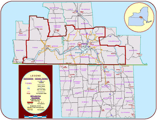
With a population of approximately 160,000, the greater Binghamton, New York, area is situated at the confluence of two rivers. Most of the development is concentrated in the river valleys. Main Street forms the spine of the region and connects the three distinct centers in Johnson City, Binghamton, and Endicott. Figure 1 shows the Binghamton metropolitan planning area.
|
Figure 1. Binghamton metropolitan planning area. |
|
|
| Courtesy of Binghamton Metropolitan Transportation Study. |
Since the 1980s, the Binghamton area, like much of upstate New York, has experienced economic decline and population loss. Because of these conditions, transportation planners find themselves grappling with issues of system preservation and economic revitalization rather than with congestion and the need for additional highway capacity.
Project Overview
As the MPO for greater Binghamton area, BMTS is responsible for periodically updating the area's long-range regional transportation plan. BMTS staff had concluded that the previous plan, developed in 2000 and entitled Transportation Tomorrow: 2025 (the 2025 plan), lacked the foundation of a clearly defined community vision. The City of Binghamton had incorporated elements of a community vision approach into its 2003 comprehensive plan but this plan was limited by the city's boundaries (3). As BMTS began preparations to update the 2025 transportation plan, the agency concluded that the new plan would not provide any new insights unless a new approach was used. Therefore, BMTS chose to adopt a scenario planning approach that would incorporate opinions, values, and visions of a wide range of community members. The scenario planning approach supplements rather than replaces the federally required public participation program for the transportation plan update.
Project Drivers
As the MPO for greater Binghamton area, BMTS is responsible for periodically updating the area's long-range regional transportation plan. BMTS staff had concluded that the previous plan, developed in 2000 and entitled Transportation Tomorrow: 2025 (the 2025 plan), lacked the foundation of a clearly defined community vision. The City of Binghamton had incorporated elements of a community vision approach into its 2003 comprehensive plan but this plan was limited by the city's boundaries (3). As BMTS began preparations to update the 2025 transportation plan, the agency concluded that the new plan would not provide any new insights unless a new approach was used. Therefore, BMTS chose to adopt a scenario planning approach that would incorporate opinions, values, and visions of a wide range of community members. The scenario planning approach supplements rather than replaces the federally required public participation program for the transportation plan update.
Major Project Issues
Most regions that have used a scenario planning process have done so in response to rapid growth, suburban sprawl, and traffic congestion. In contrast, since the 1980s, the Binghamton area has grappled with economic decline and population loss. Other challenges facing BMTS included a lack of regional cooperation among local governments and traditionally low levels of community organizing and advocacy.
Economic Decline
Binghamton had enjoyed earlier prosperous times as an industrial center. IBM was an economic anchor for the community until it began pulling out in the 1990s. The number of IBM employees in the area has fallen from about 15,000 to 1,500 people. The declining role of IBM as well as that of defense and aerospace companies in Broome County has resulted in economic adjustments for the area.
Shrinking and Aging Population
The Binghamton region has seen its population shrink due in part to the out-migration of young and highly educated residents. One outcome of this trend is that the average age of the area's population has increased, presenting the community with new challenges. The greatest declines in both population and business activity have occurred in the central city areas. At the same time, suburban growth in both housing and other land uses has continued, resulting in "hollowing of the core," a phrase used by the Brookings Institution in its Special Series on Health of the Upstate New York (4). If this trend continues, there will be a greater demand for public services in the urban core, but a declining ability to finance those services because of loss of residents and workforce (1). In the 1990s alone, the assessed value of property in the Binghamton Metropolitan Statistical Area declined 33% (5).
Lack of Regional Cooperation
According to local officials and planning staff, one of the biggest challenges is getting different agencies from the numerous jurisdictions in the Binghamton region, each with its own land use controls, to engage in cooperative dialogue concerning regional goals and strategies. This fragmented land use jurisdiction encourages parochialism and works against achieving a regional vision (2).
Little History of Community Advocacy
An issue at the outset was the level of public involvement that BMTS could achieve. The Binghamton area does not have a history of community organizing and advocacy. Some attribute this to the corporate paternalism and employer-provided benefits that characterized the major economic actors in the area, such as the Endicott-Johnson Shoe Company and, later, IBM. One interviewee identified "a collective mentality that we don't need advocacy because IBM and Endicott-Johnson are never going away." Early public comments during the scenario planning process were often backward looking, wishing the region could return to a more prosperous time (2). However, these sentiments waned as the scenario planning process proceeded.
Institutional Framework for Decision Making
Binghamton Metropolitan Transportation Study (BMTS)
BMTS is the Binghamton area's regional transportation planning agency and federally designated MPO. It is composed of a Policy Committee, a Planning Committee, and central technical staff that are housed physically and administratively in Broome County's planning department.
The Policy Committee is BMTS's decision-making body. Members include mayors or other elected officials from the villages, towns, and counties of the region, representatives of other planning agencies, and nonvoting representatives of the New York State Department of Transportation (NYSDOT), FHWA, and the Federal Transit Administration (FTA). The Policy Committee must reach consensus on all of its decisions, a mechanism aimed at ensuring that those decisions are truly regional (6).
The BMTS Planning Committee provides technical oversight of and input to the transportation planning process. Members include professional staff of member municipalities: engineers, planners, and public works officials. The Planning Committee reviews all transportation plans and programs before they are sent to the Policy Committee for consideration (6).
Project Advisory Committee
BMTS created a Project Advisory Committee of local and state technical staff from its Planning Committee to oversee and guide the scenario planning process. This committee met at key points throughout the process to track performance, fine-tune the approach, and troubleshoot issues. The committee also continued to meet as the long-range transportation plan was developed, and it served as an important forum to monitor plan implementation, address policy issues, and ensure that local planning and economic development efforts were consistent with the transportation plan (1).
Community Vision Team
BMTS formed a community vision team to provide the input into the scenario planning process and to help ensure effective outreach to community members. One interviewee described the process of assembling the community vision team as "more fluid than formal." Before any public events, BMTS staff and the Project Advisory Committee brainstormed on who could contribute to the process and drew up an invitation list of 50 to 60 people. A goal was to find people who would champion the vision and take it back to their organizations, thus helping to keep it alive. The invitees tended to be community leaders or otherwise active in local affairs. About half accepted the invitation to participate. At the first public meeting, the team invited others to join but got few responses. Team members were asked to attend the full set of visioning workshops and to be advocates within their communities for the visioning process and for the subsequent transportation plan update process. The results were mixed, with some members more active than others; a few reached BMTS's highest expectation of bringing back views of others in addition to their own views. Although the scenario planning workshops were open to the public, the community vision team ensured that a representative sample of the community would participate in the process.
Participants included BMTS officials and advisory committee members, local elected and appointed officials, business and development leaders, Binghamton University student leaders and administrators, and human service providers. The community vision team members served as "ambassadors" for the process among their respective communities and interest groups (1). They provided the study team with a valuable source of information and feedback from a wide variety of perspectives. In particular, the community vision team helped the project team by
- Providing insight and ideas on local interests and issues;
- Helping to identify key concerns, such as the needs of the elderly and people with disabilities;
- Helping with community outreach to groups such as schools and professional associations; and
- Encouraging attendance at community workshops.
The community vision team also included two town supervisors who were also members of the BMTS Policy Committee. These two officials championed the visioning product before the Policy Committee. This was important to the success of the visioning and the transportation plan because nine of the 13 Policy Committee members were elected officials, and as such they were more receptive to the views of peers than of staff.
One of Gayle's goals for this process was to broaden the set of stakeholders participating in transportation planning by bringing in fresh faces and forging new connections. For example, one community vision team member cited a "huge disconnect" between Binghamton University and city affairs. BMTS sought to bridge this gap by inviting students and administrators from the university to serve as members of the community vision team. The involvement of the students also showed to both the news media and older citizens that young people could serve as a revitalizing force in this declining, aging community. This member of the community vision team believes that, at least partially as a result of the relationships formed during the visioning process, the level of cooperation between the university and the city administration improved greatly. He also believes that this improvement increased the potential for the university's intellectual capital to contribute to the region's economic recovery.
Transportation Decision-making Process
In 2003, BMTS began preparing to update the region's long-range transportation plan. Under federal transportation planning requirements, the update needed to be completed by March 2005. Gayle began to consider incorporating scenario planning into the update process. Because the area was not experiencing major congestion or rapid growth, there was an opportunity to redirect transportation improvement funds toward the community's other transportation needs. In addition, scenario planning was consistent with an underlying principle of BMTS's work that transportation investments should support community goals and economic development. Finally, Gayle saw signs that people were thinking about particular aspects of the region and how to effect positive changes. For example, there was a growing arts community working to make Binghamton a destination for arts enthusiasts, and there were early signs of revitalization in downtown Binghamton. In addition, Broome County had recently completed an economic development plan.
To educate local officials and transportation planners about scenario planning and its potential benefits, Gayle asked FHWA if it would hold one of its peer workshops on scenario planning in Binghamton. As noted above, FHWA agreed and held the workshop in June 2004.
FHWA Peer Workshop on Scenario Planning
Approximately 30 individuals attended the 1-day workshop. In addition to local officials and planning staff, representatives of FHWA's New York Division, NYSDOT, and neighboring MPOs attended. The workshop provided participants with an overview of the scenario planning process, shared examples of other scenario planning efforts, and described available resources and tools. It concluded with a brainstorming session on the next steps BMTS should take to implement scenario planning.
Among the local officials participating in the workshop were two members of the BMTS Policy Committee. Their participation in the workshop and their later advocacy for using this approach were key factors leading to the Policy Committee's subsequent endorsement of using the scenario planning approach for the plan update. These two officials also served as members of the community vision team, which improved the credibility of the process among the other members of the BMTS Policy Committee.
To assist BMTS in the scenario planning process, the organization secured the consulting services of the Renaissance Planning Group (RPG), a planning, design, and policy analysis firm specializing in community visioning and scenario planning.
Formation of the Community Vision Team
As described above, BMTS created a community vision team to help ensure effective input from a wide representation of the community. BMTS staff and the Project Advisory Committee developed a list of 50 to 60 possible team members from different segments of the greater Binghamton population. Of these, roughly half agreed to participate. Vision team members who were interviewed felt that the members levels of talent and degree of commitment to collaboration were high.
Development of Community Goals and Evaluation Criteria
At its first meeting, the community vision team discussed the issues and goals that the team deemed most important to the future of greater Binghamton. To inform the discussion, the consultant provided summaries of the issues and goals identified in local economic development plans and other local planning documents. Using this information as a starting point, the team developed the following list of long-term goals for the Binghamton area:
- Revitalize the central business districts of Binghamton, Johnson City, and Endicott;
- Carefully shape suburban growth;
- Develop new economic engines, particularly in the areas of health care, manufacturing, and research and development;
- Leverage educational resources;
- Protect the region's natural resources;
- Attract young professionals;
- Retain mid-career families; and
- Support the senior population.
RPG then worked with the Project Advisory Committee to turn the identified core values into evaluation criteria that would measure progress in achieving these particular goals. The community vision team would use these criteria later to evaluate alternative development scenarios. RPG identified the following criteria (1):
- Percentage of regional employment in central business districts;
- Percentage of population in "enhanced community elements" that is, typical development patterns (e.g., suburban office park) that have been improved in ways identified by the vision team;
- Percentage of regional dwelling units in enhanced community elements;
- Diversity of housing mix (single family versus multifamily);
- Percentage of population within 5 minutes of existing schools;
- Acres of greenfields lost; and
- Acres of brownfield redevelopment.
RPG mapped these evaluation criteria back to the relevant long-term goals; most of the measures were mapped to more than one of the goals. The vision team then assessed whether the criteria were consistent with the long-term goals they had defined.
RPG provided support services including an urban design group that assembled aerial photographs and toured the community to identify types of communities, places, and development patterns (community elements). RPG also recorded characteristics of place types and plotted them on a geographic information system (GIS) map of the region for use later in the process when those characteristics would be varied under the alternative scenarios.
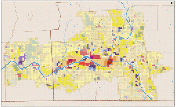
First Public Workshop: Treasured Places and Community Design
At the first workshop, held in March 2005, the community vision team and other attendees took part in two exercises. In the first exercise, participants identified "treasured places," which were defined as places or aspects of the community that have special value and that should be preserved as the community evolves. The resulting map (Figure 2) helped participants recognize their region's many assets and, by inspiring people, helped kick-start the visioning process.
Figure 2. Results of the treasured places exercise.
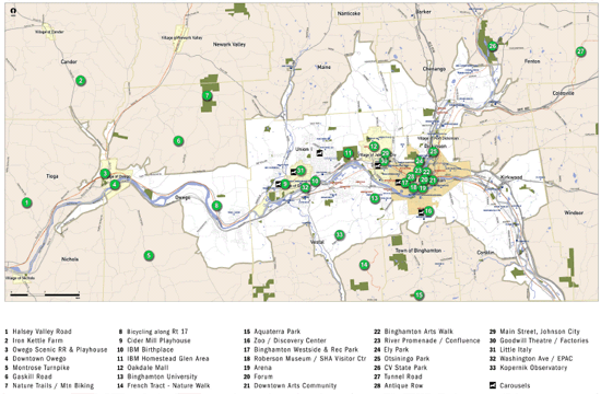
Courtesy of Renaissance Planning Group.
In the second exercise, participants discussed the pros and cons of different development patterns or land use types present in the community. RPG characterized this activity as "documenting values with words and diagrams." For each development pattern (what RPG called a "community element"), participants discussed which physical features they liked and what they would like to change in the future. The focus was on characteristics that could be changed through strategic land use and transportation investments, such as the diversity of activities, the scale and proximity of buildings, the usefulness of the transportation network, and the quality of open space (1). This was a hands-on exercise. For example, people imagined a shopping center and, using maps and markers, drew it as a pedestrian-centered area with connections to adjacent neighborhoods. Based on the input from the workshop, and other information such as population demographics and zoning maps, RPG developed a set of "enhanced" community elements that would help guide future development patterns.
The discussions at the public workshops also had to address the impression of some residents that the BMTS process was wasting scarce public funds and duplicating the city's 2003 comprehensive plan update, which had chosen an alternative called Reestablish a Vibrant Regional Center.
Second Public Workshop: Placemaking for Prosperity
Having defined the design characteristics that they would like to see in the community, participants next identified where economic development should occur at the regional level. For an area experiencing rapid growth, participants would have been asked to select areas where future growth should be directed. For a low-growth area such as Binghamton, the exercise was changed. The workshop participants were asked to brainstorm about how the region's existing infrastructure could be modified to help achieve the long-term goals established at the beginning of the process. Participants were divided into groups that focused on four economic sectors that economic development agencies had targeted as most promising for the region: arts and tourism, health care, research and development, and manufacturing (7). Table 1 shows some of the ideas that the participants generated.
Table 1. Sample Ideas for Adapting Existing Infrastructure to Achieve Community Goals
| Economic Sector | Enhancement of Existing Community Element |
|---|---|
|
Arts and tourism |
Convert dormant manufacturing facilities into artist studios |
|
Health care |
Put health care facilities in neighborhoods so they can be accessed without use of automobiles |
|
Research and development |
Use Binghamton University? research campus as an incubator for small businesses |
|
Manufacturing |
Encourage redevelopment of brownfield sites with subsidies or other tools |
Source: Renaissance Planning Group.
Workshop participants were then asked, in a "place the dots" exercise, to identify on regional maps where the modified development patterns would be located and what types of transportation services would be needed. For example, the arts and tourism group suggested that a shuttle bus serving local points of interest would help draw visitors, and the group working on the health care sector came up with transit and pedestrian improvements. RPG provided a reality check to ensure that participants placements of the "dots" were physically reasonable.
Development of Alternative Future Scenarios
Using the input of the community vision team, RPG then developed four alternative future scenarios: outward trend, outward growth, inward trend, and inward growth. The trend scenarios assumed continued population losses for the first 5 years followed by zero change afterward, resulting in a population of roughly 153,000 people. The growth scenarios assumed zero population change for the first 5 years and slow population growth afterward, resulting in a population of roughly 166,000 in 2030.
The terms "inward" and "outward" refer to the land use pattern that future development would take. The two outward scenarios assumed the continuation of current trends: slow suburban development and loss of population and economic activity in urban centers. The inward scenarios assumed most development would occur in the area's urban core communities of Binghamton, Johnson City, Endicott, and the Village of Owego.
RPG used the Community-Based Regional Planning Model, or CorPlan, to forecast the development patterns and resulting impacts of the four alternative scenarios. CorPlan is a community-based land use planning model that estimates land development potential using prototypical community definitions, or "community elements," as its building blocks (8). CorPlan estimates land development potential and how that potential translates into the location of households and jobs (9). This information is used to generate development scenarios and the associated transportation options for the region. The Thomas Jefferson Planning District Commission developed CorPlan for the Charlottesville, Virginia, region in response to two concerns: (1) growing traffic congestion and public reluctance toward road expansion, and (2) the inability to use existing tools to implement adopted planning goals and "livability" policies for the region (10). The model runs in a Microsoft Excel spreadsheet with links to the ARCVIEW GIS software. The GIS-based software provides the ability to visualize and evaluate development scenarios.
Using the Model
CorPlan uses neighborhood-level community elements that are described in terms understandable to the public and supplemented by photographs and clear diagrams. In a public outreach process, citizens use the photos and diagrams to compare the various development scenarios instead of having to rely on numbers to envision the results. This allows them to actually see what the alternatives would look like in their community and how individual community elements fit together to generate a regional plan. The process starts small by focusing on community elements, each representing the development and infrastructure characteristics of a 31-acre area the area of a circle with a quarter-mile diameter. The quarter-mile distance was chosen because it is considered the maximum distance most Americans will walk and walking distance is considered to be the appropriate scale for community elements. Each element reflects a unique existing or planned land development pattern. Using GIS software, the consultant illustrated each community element with a plan graphic and photos to convey the look and feel of the element (see Figure 3). RPG also defined each element with land use, infrastructure, and socioeconomic information, which was used to estimate the development potential of an area.
Figure 3. Community element with quarter-mile-diameter circle.
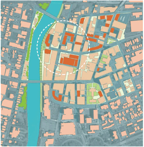
Courtesy of Renaissance Planning Group.
The process incrementally scales up into a regional plan. Users estimate land development potential in CorPlan by assigning each community element to a larger subarea of the region. The subareas may be defined for compatibility with other models for example, by a set of traffic analysis zones. CorPlan multiplies the land use, infrastructure, and socioeconomic characteristics of the selected element by the total useable land in the subarea. The model sums the development potential for all subareas to estimate the total development potential for the region. Users can quickly test alternative development scenarios by reassigning or "enhancing" the community elements, and the model calculates new totals. Figures 4 and 5 show two of the alternative scenarios, "suburban migration, moderate growth" and "urban revitalization, moderate growth." Also, as alternative scenarios are tested, CorPlan automatically generates socioeconomic inputs for travel demand modeling.
Figure 4. Development pattern of suburban migration, moderate growth.
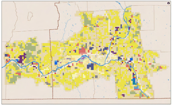
Courtesy of Renaissance Planning Group.
Figure 5. Development pattern of urban revitalization, moderate growth.
Courtesy of Renaissance Planning Group.
Third Public Workshop: Evaluation of the Alternative Scenarios
At the last public workshop, the vision team and other attendees were shown the results of the land use modeling and how the four alternative scenarios compared according to the evaluation criteria the team had agreed on previously (see Table 2). By consensus, the vision team preferred the inward growth (urban revitalization) scenario.
Table 2. Comparison of the Four Alternative Scenarios (1)
|
Scenario Evaluation Criteria |
Suburban Migration (Outward) |
Urban Revitalization (Inward) |
||
|---|---|---|---|---|
|
No Net Growth |
Moderate Growth |
No Net Growth |
Moderate Growth* |
|
|
Percent of regional employment in central business districts |
63 |
53 |
72 |
78 |
|
Percent of housing in central business districts & enhanced communities |
53 |
52 |
65 |
69 |
|
Housing diversity (% single-family / % multi-family) |
61/39 |
57/43 |
38/62 |
50/50 |
|
Percent of population within 5 minutes of existing schools |
27 |
25 |
32 |
31 |
|
Acres of greenfields used for development |
500 |
3,000 |
125 |
175 |
|
Acres of brownfield redevelopment |
0 |
85 |
0 |
130 |
* Preferred scenario.
Incorporation of Preferred Scenario into Long-Range Transportation Plan
The vision team first presented their recommendation to the BMTS Planning Committee. The Planning Committee agreed and recommended that the Policy Committee adopt the "inward growth" scenario as the guiding vision for the long-range plan update. The Policy Committee subsequently endorsed the preferred scenario.
To complete the rest of the long-range transportation planning process, BMTS staff used the land use and population outputs from the preferred scenario as inputs for the regional travel demand model. This step required some extra technical work because the MPO's traffic analysis zones did not coincide with the smaller, quarter-mile units of analysis used in CorPlan.
The preferred scenario was also incorporated into the various elements of the regional transportation plan. Applying the vision team's work to all of the required elements such as system preservation, safety, and security required the discretion of the BMTS central staff, because the vision team had not been asked to address each of these elements.
How the 2030 Plan Differs from its Predecessor
Because of the input that the community vision team provided, Transportation Tomorrow: 2030 differs from its predecessor in that the 2030 plan
- Places greater emphasis on revitalizing key "gateway" urban corridors;
- Prioritizes the preservation of urban arterials over those in suburban areas;
- Emphasizes transportation investments that support waterfront redevelopment plans;
- Accelerates implementation of the regional greenway trail system; and
- Formalizes the MPO's activities to improve bicycle and pedestrian safety.
Although Transportation Tomorrow: 2030 is a 25-year plan, the change in priorities and direction are already evident in BMTS's short-term planning documents. For example, the BMTS 5-year Transportation Improvement Program includes a new NYSDOT-sponsored project to construct a portion of Binghamton's greenway trail system using National Highway System Funds (11). This project is scheduled for obligation in 2010.
Binghamton's plan earned a 2006 National Award for Outstanding Technical Merit in Metropolitan Transportation Planning from the Association of Metropolitan Planning Organizations and a 2006 Honorable Mention from the Transportation Planning Excellence Awards Program run jointly by FHWA and FTA.
Lessons Learned
Success Factors
Support from MPO Leadership
The early and continuing support of members of the BMTS Policy Committee helped BMTS staff win approval to use scenario planning for its long-range plan update. The two town supervisors who attended the FHWA workshop and who were Policy Committee members were critical to building this support. Without this support, it is not clear that the staff would have received the approval to depart from its traditional methodology.
Small Size of the Region ?Local Officials Represented both Urban and Suburban Areas
Several sources noted that the small size of the region compared with most MPO planning areas meant that participants were more likely to know each other and to be familiar with concerns other than their own. For example, in some communities the decision to focus transportation investments on urban centers would have provoked opposition from representatives of suburban businesses and neighborhoods. In Binghamton, however, the local officials serving on the MPO Policy Committee represented both urban and suburban areas. As a result, they were less constrained by narrow or parochial interests.
Breadth of Stakeholder Participation
The diversity of perspectives represented on the community vision team was important to the success of the planning process. It offered credibility to the decision makers to know that a wide range of stakeholders approved of the preferred scenario. Vision team members who were interviewed believed that the process was successful in generating ideas, acknowledging the concerns of stakeholders, and increasing mutual understanding of stakeholder concerns. However, one of the vision team members who was interviewed said that few people without business or institutional ties attended the vision team and public meetings, and thus the interests of the public at large may have been underrepresented.
Consultant Support of Visioning Process
Because this was the first attempt by BMTS to do scenario planning, having the support of an experienced consultant was critical to the success of the process. The consultant, Renaissance Planning Group, brought a specific set of tools adapted to the scenario planning exercise.
Technical Ability of MPO Staff
The MPO staff's strong technical abilities were also important to the success of the planning process. The staff members were able to adapt to the new planning approach and resolve the technical issues that arose.
Key Innovations
Adaptation of Scenario Planning for a No-Growth Region
As noted previously, Binghamton was one of the first no-growth communities to try scenario planning. Because of this, RPG needed to adapt some of the exercises typically used with high-growth areas. For example, rather than identify appropriate areas for future growth, participants brainstormed about how the region's existing infrastructure could be modified to facilitate the types of economic activity identified as the area's most likely sources of future growth.
Scaling of Scenario Planning Process for a Smaller Community
RPG pared its scenario planning process down to 6 months from the 12- to 18-month process it typically uses. Some of the time saving was achieved by dispensing with travel demand modeling of the alternative future scenarios. BMTS and RPG deemed this modeling unnecessary because of the lack of congestion and the low-growth assumptions underlying the scenarios. (BMTS later modeled the preferred scenario as part of preparing the regional transportation plan.)
Barriers Encountered and Solutions
Schedule Issues
BMTS got a late start on the process of updating its long-range transportation plan because of the early discussions about adopting the scenario plan approach and the scheduling of the FHWA peer workshop in Binghamton. Because of this, BMTS was faced with missing its deadline for completing the update. Fortunately, because the plan in place at the time had a 25-year time horizon (5 years longer than the federal requirement), FHWA and FTA were able to grant BMTS an extension. The schedule delay, although inconvenient, was necessary to allow BMTS time to build local support for the scenario planning approach.
Data Issues
BMTS encountered some technical challenges in moving the output from the consultant's land use model into its travel demand model. As described above, the land use model used quarter-mile units of analysis. These units did not automatically mesh with the traffic analysis zones used in the BMTS travel demand model. Thanks to the technical ability of its staff, BMTS was able to overcome these technical obstacles.
The land use modeling used in this planning process required a great deal of GIS data on environmental constraints, existing and planned land uses, and socioeconomic conditions. Because BMTS is housed within Broome County's planning department, it has strong GIS capabilities and good access to data. Other small MPOs might have had more difficulty providing the necessary data.
Other Lessons Learned
Managing Expectations of the Visioning Process
A few participants had expected to discuss specific transportation projects during the visioning or felt that the visioning was too vague or unrealistic. RPG observed that delving too quickly into details such as zoning changes and project specifics is not productive without a well-articulated vision to which people can refer; the time to consider projects is during the development of the transportation plan. This misunderstanding might have been prevented if BMTS had explained clearly what the visioning process would produce and what it would not, so that participants would not be confused or disappointed, and had described more clearly for participants how the visioning process related to the rest of the transportation planning process.
Keeping the Community Vision Alive
Neither BMTS staff nor community vision team members could point to a final written product that summarized the vision team's work. Some of the participants alluded to a final document that assigned responsibilities for actions needed to achieve the community's long-term vision. However, the vision team members who were interviewed did not recall seeing such a document. However, Binghamton is a small community and the results of the visioning process seem to have been shared informally.
Some participants who were interviewed wished BMTS had held an additional meeting to show how the results of the visioning exercise had been incorporated into the final transportation plan. In addition, they expressed interest in having a final document for reference when discussing local planning and development issues. The document also would show how the regional transportation plan supports and coordinates with other plans such as the City of Binghamton's comprehensive plan and Broome County's economic development plan. Efforts to advocate for and implement vision plans may be more effective, particularly in larger communities, if the agency produces and distributes such a document so that the visioning results can be applied more easily in the transportation planning process and in other community planning efforts.
References
1. Gayle, S., C. Paddick, J. Sterbentz, and S. Reigle. Transportation Tomorrow: 2030 Placemaking for Prosperity. The Transportation Plan for Greater Binghamton. Binghamton Metropolitan Transportation Study, Binghamton, N.Y., 2005. http://bmtsonline.com/files/bmts/pdfs/TransportationTomorrow2030.pdf. Accessed Sept. 9, 2010.
2. Federal Highway Administration, U.S. Department of Transportation. Scenario Planning Peer Workshop Binghamton, NY. Accessed Sept. 13, 2010.
3. City of Binghamton, N.Y. City of Binghamton Comprehensive Plan, 2003. www.cityofbinghamton.com/department.asp?zone=dept-planning&pid=113&pm=page#CompPlan. Accessed Sept. 8, 2010.
4. New York Economic Development, Cornell University. Economic Development Planning Research and Upstate New York. Special Series on the Health of Upstate New York, Metropolitan Policy Program, Brookings Institution, Washington, D.C., 2003-2004. www.nyecon.cornell.edu/research/upstate.mgi. Accessed Sept. 9, 2010.
5. Pendall, R. Sprawl Without Growth: The Upstate Paradox. Brookings Institution, Washington, D.C., 2003. www.brookings.edu/~/media/Files/rc/reports/2003/10demographics_pendall/200310_Pendall.pdf. Accessed Sept. 9, 2010.
6. Broome County, N.Y. Binghamton Metropolitan Transportation Study. http://bmtsonline.com/bmts. Accessed Sept. 9, 2010.
7. Angelou Economics. Broome County Plan for Sustainable Economic Development. Broome County, N.Y., 2002. www.gobroomecounty.com/files/planning/_pdf/BCPlan_Implementation_Plan.pdf. Accessed Sept. 13, 2010.
8. Renaissance Planning Group. Community Elements Model. www.citiesthatwork.com/imodels/CorPlanInfoSheet.htm. Accessed Sept. 13, 2010.
9. Federal Highway Administration, U.S. Department of Transportation. Resources: Land Use and Transportation Modeling Tools CorPlan Model, Charlottesville, VA. . Accessed Sept. 13, 2010.
10. Twaddle, H., and C. Sinclair. How the CORPlan Model Was Used to Develop a Community Vision for Charlottesville, Virginia, and Surrounding Area An Integrated Land Use and Transportation Modeling Effort. In Transportation Research Circular E-C054: Community Impact Assessment in the 21st Century: Making Connections and Building Relationships. Transportation Research Board of the National Academies, Washington, D.C., July 2003, pp. 64-68. http://onlinepubs.trb.org/onlinepubs/circulars/ec054/CircE-C054 CIA.pdf. Accessed Sept. 13, 2010.
11. Binghamton Metropolitan Transportation Study. Annual Listing of Federal Aid Project Obligations, Federal Fiscal Year 2009. http://bmtsonline.com/files/bmts/pdfs/Annual%20Listing%20of%20Project%20Obligations%20FY%202009.pdf. Accessed Sept. 13, 2010.
For More Information
Steven Gayle
Executive Director
Binghamton Metropolitan Transportation Study
(607) 778-2443
Hannah Twaddell
Project Manager
Renaissance Planning Group
(434) 296-2554