
US Department of Transportation
FHWA PlanWorks: Better Planning, Better Projects
Illinois Prairie Parkway Project (Illinois Department of Transportation)
Overview
Project Overview
The Prairie Parkway is a proposed new location highway currently under study, led by the Illinois Department of Transportation (IDOT), District 3. The purpose of the Prairie Parkway Study is to take an in-depth look at current and future transportation needs in an area that is experiencing growing regional development demand and increasing traffic congestion (1). The project is located in northeastern Illinois in Kane, Kendall, Grundy, DeKalb, LaSalle, and Will Counties, west of the city of Chicago. The study will also identify a transportation system improvement or improvements that will help enhance north-south mobility between I-80 and I-88 and that will address project needs. Four needs have been identified that the project must satisfy. The proposed transportation system improvement must
- Improve regional mobility by providing more north-south, higher-speed multilane roads or additional lanes to serve traffic growth and reduce regional travel times for longer-distance travel;
- Address local system deficiencies by serving the study area's projected growth in local traffic and by improving travel times;
- Improve access from the study area to regional jobs by serving the growth in work trips and by improving mobility from the study area to current and future jobs; and
- Improve safety by reducing existing and projected growth in motor vehicle crashes.
The project was initiated in the late 1990s as a feasibility study. As the study progressed, development in the project study area was occurring at a rapid pace. When this became evident to the project team, the project goal was shifted from a feasibility study to a corridor preservation project. A public hearing was held in an effort to preserve the corridor from further development. In 2002, IDOT recorded a protected corridor for a potential transportation facility to be built if and when one was needed. At that time, there had not yet been any National Environmental Policy Act (NEPA) analyses or environmental studies, other than cursory evaluations that occurred during the feasibility study and corridor preservation study phases of the project.
Later in 2002, IDOT began a preliminary engineering study. The preliminary engineering study was not bound by the results of the corridor protection process. It was meant to determine if transportation system improvements were needed and, if there was a need, the type and location of improvements that would best meet that need.
The study first analyzed transportation system performance without major new improvements, and identified existing and potential future deficiencies. Once the need for transportation improvements was established, the project development/NEPA process was formally initiated with the publication of a notice of intent in the Federal Register on September 10, 2004.
During the course of study, a variety of alternative solutions were developed and analyzed. A draft environmental impact statement (DEIS) was prepared (2), a public hearing was held, and a preferred alternative was selected. The final EIS is currently being prepared. The preparation of a record of decision is expected to follow.
Screening Process Overview
As previously mentioned, before the start of the current project development/NEPA study, IDOT had completed a corridor protection study. The corridor protection study began as a feasibility study in March 1999 to evaluate the ability to develop a north-south transportation corridor between I-80 and I-88. That study was initiated because of concerns that development patterns and increasing travel demands could overload the existing transportation network in Grundy, Kendall, and Kane Counties. Through that study, several north-south corridors were investigated that would connect the major transportation routes of I-80 and I-88, while providing access to the existing arterial system. The study examined constraints, including urban areas and existing development, planned growth, floodways, wetlands, parks and preserves, and threatened and endangered species.
On the basis of this analysis, IDOT elected to implement the corridor protection process to select a possible transportation corridor and protect that corridor while it was still reasonably undeveloped and open. The corridor protection process would minimize impacts to future developed areas and allow planners time to develop growth strategies compatible with the transportation facility. A public hearing was held on December 11, 2001, to present three corridors to the public for their review and comment. On July 31, 2002, the Illinois secretary of transportation signed the Record of Hearing for the Prairie Parkway Corridor Protection, approving the modified central corridor. This corridor protection map was recorded in Grundy, Kendall, and Kane Counties.
During the studies that led to the recording of the central corridor, IDOT recognized the need to take a comprehensive look at the transportation system of the study area. A formal project development/NEPA study for this purpose was proposed by IDOT, and federal funding was obtained.
The project development/NEPA process was initiated on December 20, 2002. The project was undertaken in parts. Part A included the studies to determine insufficiencies in the transportation network, and Part B included the development of purpose and need and alternatives for further evaluation. The study was designed such that studies under Part B would not be initiated unless Part A studies demonstrated that project needs existed.
The first step of the study (Part A) included analyzing the existing and future conditions and defining the purpose of and needs for improvements. The subtasks generally included collecting information on current population, employment, and traffic conditions; developing a geographic information system to organize and display the data; forecasting future population and employment growth in the area; predicting future travel demand; and evaluating the performance of the transportation system under future conditions.
With this information, IDOT was able to identify transportation deficiencies and begin the planning process for developing local and regional solutions to address these deficiencies (3). The population and employment forecasts led to an estimate of travel demand. From this estimate, current and future transportation system performance was evaluated, resulting in the identification of transportation system needs. Public involvement was integrated into this process. The identified transportation deficiencies indicated the need for some type of north-south transportation improvement.
As Part B of the study began, the deficiencies were addressed in greater detail and the project needs were defined. Alternative solutions that met the defined project needs were then identified and analyzed during the project study. The consideration of potential alternatives to meet the identified project needs included an extensive stakeholder involvement program.
At meetings throughout the study area, the public was provided with information about the results of the Part A studies. Transportation deficiencies and the predicted travel demands were presented at citizen informational workshops. Attendees were invited to comment and develop their own ideas to address the transportation needs. During the course of these workshops, the public and other stakeholders identified more than 150 ideas that were organized into a set of preliminary alternatives that included arterial roadway improvements, new freeways, transit improvements, and congestion management strategies. The goal of the process was to begin with a wide range of alternatives and then narrow them through evaluation to those that were reasonable and feasible and would best address the project need.
The location of these preliminary alternatives spanned the full study area of Kendall County, eastern portions of LaSalle and DeKalb Counties, northern Grundy County, western Will County, and southern Kane County. To identify alternatives to be analyzed in detail in the DEIS, these preliminary alternatives had to undergo a screening process that would result in alternatives best suited to meet the project needs.
The screening of the preliminary alternatives was accomplished primarily through traffic and travel demand analyses. The alternatives were analyzed, or screened, for their effectiveness to satisfy the transportation needs established early in the study. In addition to traffic and travel demand data, environmental (human, physical, and natural) impact data were also analyzed. This information was presented to the stakeholders through the use of comparative analysis matrices included in handouts and PowerPoint presentations. The public was invited to comment on the screening process and results that concluded with alternatives recommended for detailed study in the DEIS. Decisions on the final alternatives were made through a consensus process (NEPA/404 merger process) established by IDOT, the Federal Highway Administration (FHWA), and the U.S. Army Corps of Engineers (USACE). The environmental data, along with stakeholder (the public, interest groups, and agencies) comments were evaluated in the decision-making process.
Following the identification and analysis of the detailed study alternatives, a second screening process, similar to that for the screening of the preliminary alternatives, was undertaken to identify a preferred alternative solution.
The screening processes were generally considered a success. Detailed study alternatives were identified at the second merger meeting, the first being a meeting to establish the project purpose and need. A preferred alternative was also identified, facilitated by the third merger meeting.
Key Aspects of the Screening Process
Scope
When the project first evolved, full consideration was given to land use and growth in the project area. This is evident from the corridor preservation efforts that occurred early in the project's history. Screening processes, however, were not introduced until the project development/NEPA phase. The screening process associated with the preliminary alternatives took into consideration environmental resources, as well as land use, economics, and secondary development.
Initially, alternatives included travel demand management, transportation systems management, transit, improvements to existing roadways, and new location highways. The no-build alternative was also analyzed to provide a baseline comparison. The alternatives studied in the DEIS include new location highway corridors, along with certain improvements to existing arterial systems.
Communications
Agency Involvement
Overview. All regulatory and resource agencies were included in the screening processes. Each had its own role, which was to comment on its respective agency interests and jurisdiction.
IDOT, FHWA, and USACE entered into a NEPA/404 merger process in the early 2000s. This process was widely accepted by the regulatory and resource agencies and was effectively implemented for the Prairie Parkway Project. The merger process includes three concurrence points: (1) purpose and need, (2) identification of detailed study alternatives, and (3) selection of the preferred alternative.
Agencies were initially involved by notification through distribution of scoping letters. Meetings were held at each of the three concurrence points, or steps, in the merger process. The NEPA/404 merger process, although not necessarily innovative, was very effective and a widely accepted means for decision making.
Although IDOT, FHWA, and USACE were the primary decision authorities, all agencies in attendance had an opportunity to comment, and decisions were made through concurrence of meeting attendees. Participants in the meetings included IDOT, FHWA, and regulatory and resource agencies. Although IDOT was essentially responsible for the final decisions, the agencies had a tremendous influence on the outcomes.
Screening Process. Alternatives screening occurred at the second concurrence point, identification of detailed study alternatives. Information about the screening methodology, public comments, and comparative analysis matrices were distributed to the merger team/agency members before the agency meeting. During the meeting, IDOT and its consultant delivered a PowerPoint presentation that outlined the screening process by describing how the approximately 150 initial alternatives evolved and how they were grouped into several primary corridor locations and then screened to identify those that would be studied in greater detail. Discussion at the meeting resulted in concurrence on the alternatives selected for detailed study in the DEIS.
Public Involvement
During the corridor preservation process, there was no public involvement until a corridor had been identified. A public hearing was held in 2002, and the corridor was formally adopted for preservation.
As the project development/NEPA study evolved, informational workshops and meetings were held at virtually every step of the study process. The public was also invited to comment at the project outset, before the development of preliminary alternative study corridors, and at numerous points throughout the project:
- January 22 and 23, 2003, open house workshop attended by 230 people;
- October 2003, four focus group meetings;
- March 17 and 18, 2004, public information meeting on purpose and need;
- July 2004, public workshop to generate alternatives;
- January 2005, informational meeting where 150 alternative concepts were presented,
- April 4 and 5, 2006, public information meetings attended by 600 people; and
- July 11 and 12, 2007, public hearings.
This is not an unusual or innovative public involvement program, but developing focus groups that included community leaders, farmers, business owners, and interest groups was effective in identifying issues and generating solutions.
Information was effectively conveyed to stakeholders through newsletters, handouts, PowerPoint presentations, and graphic displays at the workshops. The prepared information was simple, easy to read, and graphically clear. The PowerPoint presentations were well prepared and the associated voice-overs included clear explanations of the study methodologies employed. Handouts were colorful, concise, and easy to understand.
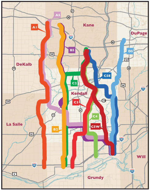
During the July 2004 workshop, the public was invited to suggest alternatives that in their opinion provided solutions to the transportation deficiencies. They were given maps on which they could draw alignments and offer transportation improvement recommendations. Approximately 150 alternative solutions were identified. IDOT and its consultant performed an iterative conceptual layout process for the alternatives to reduce impacts where appropriate. Many of the alternatives were grouped by commonalities (Figure 1). These were divided into arterial improvement alternatives (Figure 2) and freeway alternatives (Figure 3).
The alternatives were evaluated for environmental impacts through the use of a scoring and ranking process. An example is shown in Figure 4. The complete set of preliminary alternatives along with the iterative conceptual layout process and screening methodology were presented at a public informational meeting held in January 2005. From the evaluation of the alternatives and public comments received at the informational meeting, recommendations for alternatives to be carried forward were made and then presented to the agencies for final concurrence.
Comments were summarized and made available to attendees at the merger meetings. Public comments were considered by the decision makers, but to what degree is difficult to isolate.
Suggested transportation improvement options (2).
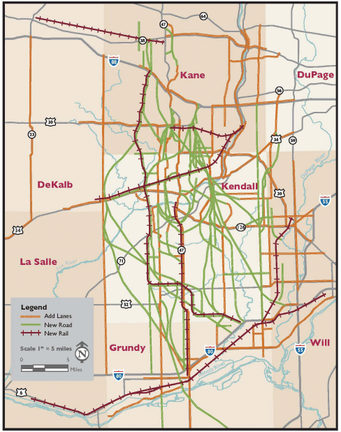
Courtesy Illinois Department of Transportation.
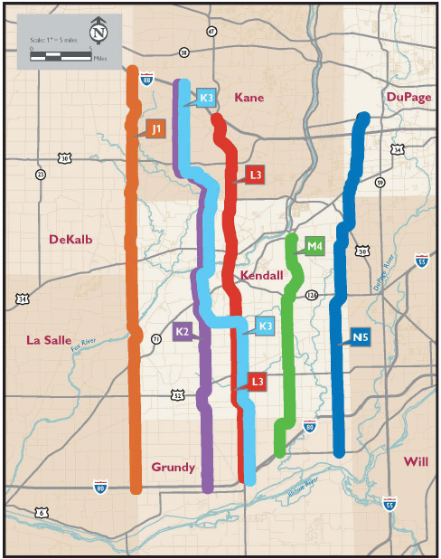
Freeway alternatives (2).
Courtesy Illinois Department of Transportation.
Comparative analysis of alternatives (2).
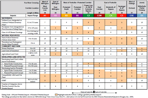
Courtesy Illinois Department of Transportation.
Technology
Project-specific or study-specific technology was not used for the Prairie Parkway. Typical analyses, such as traffic forecasting, land use and growth projections, and travel surveys, were conducted. The results of these analyses were effectively conveyed to the public and agencies through PowerPoint presentations and handout materials.
The project study team used TranPlan for traffic forecasting, ArcGIS to catalog and map resources, and VISSIM for traffic simulation. The team also used a modification to a traffic forecasting model. Typically, traffic forecasting models use land use development scenarios as input data for forecasting traffic. The modified version looked at forecast traffic data and distributed the traffic back to land use. This is a somewhat innovative approach but is not widely used. There are land development models that may be more widely accepted (e.g., UrbanSim).
Metrics and Data
Data evaluated during the screening processes were predominantly field collected. The comparative analysis of the alternative solutions was typical of project development/NEPA studies of this nature.
Lessons Learned
Success Factors
Several things contributed to the project success. First, there was extensive public involvement during the development phase of the project. Project stakeholders, including the agencies, the public, and interest groups, were highly engaged in the study process, and study results and findings were readily available to anyone with interest in the project. Second, the merger process developed by IDOT, FHWA, and USACE was extremely effective with regard to decision making.
Key Innovations
The merger process was somewhat unique. Many departments of transportation are implementing this type of process in their decision-making programs. Further, the presentation of study findings was very effective. The graphic displays, along with the written materials, were very successful in conveying the data to stakeholders.
Barriers and Solutions
The foremost barrier to the process was the determination of a preservation corridor before stakeholder involvement. This decision gave stakeholders the perception that the corridor identification was politically motivated. When the project development process began, some stakeholders believed that the corridor was preselected and studies were red herrings.
A representative from IDOT suggested that the corridor preservation phase of the study could have been undertaken as a Tier 1 NEPA study. By doing so, the stakeholders would have been engaged early and data collection efforts would have allowed for better decision making. It was further noted that there are no real regrets about how the study unfolded. The project is located in an area identified as one of the fastest growing in the nation, if not the fastest. Corridor preservation was necessary in the interest of developing additional transportation capacity. The corridor preservation process minimized impacts to residences and businesses that might have otherwise occurred.
Regardless, stakeholders should be engaged at the very early project stages, including funding, planning, and programming.
Recommendations
The process should be easily transferable. Most of the tools and techniques used during this study are common for NEPA projects of this nature. The merger process may experience institutional barriers within some states, but FHWA has strongly supported these programs, which should facilitate their implementation.
References
1. Illinois Department of Transportation. Prairie Parkway Study. www.prairie-parkway.com. Accessed April 28, 2010.
2. Illinois Department of Transportation. Draft Environmental Impact Statement, Prairie Parkway Study, Grundy, Kendall, and Kane Counties, Illinois. www.dot.state.il.us/desenv/pp_deis/pp_deis.html. Accessed April 28, 2010.
3. Illinois Department of Transportation. Prairie Parkway Study Report
Identifies Transportation Deficiencies. Accessed April 28, 2010.