
US Department of Transportation
FHWA PlanWorks: Better Planning, Better Projects
| Framework Applications | |
|---|---|
Colorado STEP UP
Environmental Collaboration Supported by Web-based Technology
Executive Summary
Over the past decade, Colorado has been steadily improving its environmental planning process. Statewide efforts, including the Colorado Environmental Forum and the Colorado Conservation and Transportation Planning Workshop, have fostered not only an increased understanding between the Colorado Department of Transportation (CDOT) and environmental resource agencies, but have spawned a demonstrated forward-thinking project to streamline the integration of environmental considerations into long-range transportation planning. The project—Colorado’s Strategic Transportation, Environmental, and Planning Process for Urbanizing Places (STEP UP)—represents a partnership among CDOT, the US Federal Highway Administration (FHWA), Region 8 of the US Environmental Protection Agency (USEPA), and the North Front Range Metropolitan Planning Organization (NFRMPO).
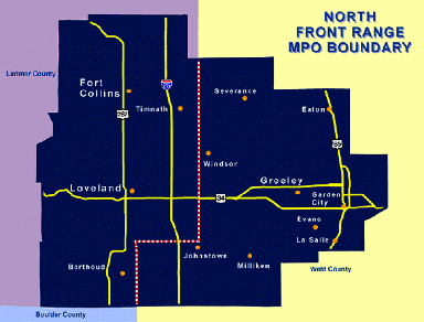
The NFRMPO region spans the area north of Denver to the Fort Collins metropolitan area. Interstate 25 (I-25), the major north-south corridor, bisects the area. The MPO Boundary encompasses 600 square miles and is home to approximately 380,000 residents.1 The NFRMPO has been steadily refining its models for travel demand and land use and expanding its Geographic Information System (GIS) capabilities for the past several years.
|
Figure 1. NFRMPO Boundary Map
|
Because the North Front Range is considered one of Colorado’s most innovative MPOs, the EPA and FHWA representatives for the region identified the opportunity to pilot an integrated planning project through the use of an environmental streamlining grant. These champions envisioned an opportunity to link land use and environmental concerns with a strong planning process in order to facilitate a true understanding of the issues and opportunities among all planning partners. The resulting process has advanced the technology needed to support this collaboration although a clear understanding of the process and the benefits took longer than anticipated to emerge. The first two phases of the STEP UP pilot project have resulted in a defined process for regional transportation planning that incorporates environmental review facilitated by a web-based, interactive GIS tool. Phase III will expand this capability to the statewide level. CDOT is actively pursuing this final step with the GeoMap system launched in November 2006.
Although CDOT has been engaging the resource agencies in collaborative efforts for several years, the STEP UP pilot project was the first opportunity for the agency representatives to participate in decision making during the long range planning process. The 2035 Regional Transportation Plan (RTP) used the GIS tool to examine environmental issues within the identified priority corridors. Environmental data limitations and staff availability presented obstacles to complete success, but this has promoted a statewide effort to collect, house, and maintain data that supports the transportation process. The overall consistency of the Colorado long range planning process at the state level will ultimately facilitate uniform application of both the tool and data. An additional long-term benefit is an improvement to the NEPA process through its linkage to planning.
Because the STEP UP tool requires the input and validation of the resource agencies, their involvement in the planning process is assured. Continued participation in this level of decision making will promote a mutual understanding of roles and responsibilities as well as missions and mandates. As more structure is created around this process and it is expanded to the entire state, there will be a strong reluctance to abandon the systems and processes created. Given this dynamic, the process is almost guaranteed to improve over time.
Background
Federal guidance to streamline environmental review and to link planning with NEPA has been available since Transportation Equity Act of the 21st Century (TEA-21) legislation. Specifically, Section 1309 of TEA-21 promotes expedited and integrated environmental review processes for transportation projects. Section 6002 of the Safe, Accountable, Flexible, Efficient, Transportation Equity Act: A Legacy for Users (SAFETEA-LU) builds on the intent of Section 1309 with additional support for integrating environmental review into the planning process.
Colorado has been actively involved in integrating transportation planning with the environment for several years. The Transportation Commission adopted CDOT’s environmental ethic as official transportation policy in 2003. In addition, FHWA and CDOT have entered into a Stewardship Agreement.2 Other efforts to couple environmental considerations with transportation planning include the following activities:
|
|
- Colorado Conservation and Transportation Planning Workshop, August 2006. The FHWA Project Development and Environmental Review Office, the FHWA Colorado Division, CDOT, Pikes Peak Area Council of Governments, NatureServe, and Defenders of Wildlife hosted this workshop to promote the use of data, tools, and frameworks that advance environmental stewardship and streamlining initiatives within the transportation planning process. It provided a venue for unprecedented collaboration among transportation and conservation communities. As a follow-up to the workshop, CDOT sent state resource agencies a list of datasets it proposed to use for transportation planning analysis, and the resource agencies provided comments that CDOT is considering. Also, the Colorado Pikes Peak Metropolitan Planning Organization (MPO) and CDOT are working with the Colorado Natural Heritage Program (CNHP) to test the use of NatureServe Vista (a land use planning decision support tool).3
- Linking Planning and NEPA Guidance, March 2007. This guidance supports the efforts of the CDOT and its regional transportation planners to integrate NEPA information into select regional and statewide corridor visions. It also suggests ways to incorporate data analysis and products and transportation planning products into project-level environmental review.
- Colorado Environmental Forum, March 2007. CDOT sponsored an interactive event to promote the development of relationships between transportation planners and resource and regulatory agencies. Representatives from each group were encouraged to discuss substantive, but not project-specific, issues. The goal was to achieve mutual understanding of each group’s mission and responsibilities and their relevance to the NEPA process.
- Colorado Department of Transportation's Interactive Linking Planning and NEPA Training. This training provides CDOT and its regional transportation planning partners with guidance on integrating relevant NEPA information into statewide and regional transportation planning processes. The training also addresses how to incorporate data, analysis methods, and products compiled during the transportation planning process into project-level environmental reviews. It includes the recent SAFETEA-LU requirements, particularly the new environmental consultation and mitigation requirements for transportation planning.
- Colorado Shortgrass Prairie Conservation Initiative. This CDOT initiative is an effort to conduct habitat-impact review for 36 species at the project planning stage. It seeks to mitigate potential adverse impacts to Endangered Species Act-listed, candidate, and other threatened species, in advance, for CDOT’s capacity and renewal program. Collaboration for the Iinitiative involved the State Department of Natural Resources (DNR), US Fish and Wildlife Service (US FWS), Colorado Division of Wildlife (CODW), The Nature Conservancy (land manager and biological lead), and the State Natural Heritage Program (GIS analysis). The Shortgrass Prairie Initiative won environmental awards from the American Association of State Highway and Transportation Officials (AASHTO) and FHWA as well as a USFWS leadership award given to the Colorado Field Office Director.
-
Environmental Overview Study (EOS) Process in Region 4. The EOS process includes a process for transportation planning and design that incorporates a strong environmental component. As one part of this effort, the future needs for right-of-way were identified so that appropriate set asides could be made as areas adjacent to the highways are developed; studies included mapping of key environmental resources. Currently, EOSs are ongoing on segments of US 287, State Highway (SH) 392, and SH 60. Although the NEPA process neither requires nor recognizes them, these studies will serve as a basis for future studies and right-of-way plans, and they help identify any environmental issues of concern early in the planning process.5
The trh2ansportation planning process in Colorado is unique in its degree of standardization between the state and regional planning partners. Colorado has 15 Transportation Planning Regions (TPR), all of which are engaged in long-range transportation planning with support from CDOT as needed. Only five of the TPRs represent MPOs, indicating that the state is largely rural. Of the five MPO regions, three are designated air quality non-attainment areas and therefore have a shorter planning cycle. CDOT, however, has established a statewide planning-update cycle that is consistent among all regions. This planning cycle forms the basis for the Statewide Transportation Plan.
The standardized planning process is effecting changes that go beyond simply making the planning cycles consistent across the state. The statewide plan incorporates all regional TPR plans. As a result, more than 4,000 projects have been active at any one time. Recognizing that available federal funding is limited and resources therefore must be focused toward the greatest needs, CDOT has moved from a planning process that is project-based to one that is corridor-based. CDOT made this decision during the 2030 RTP and integrated it into the 2035 RTP process. The establishment of 400 regional corridors greatly facilitates corridor-level environmental review across the state. The NFRMPO region contains 19 regional corridors grouped into three tiers of relative importance. Three of these corridors are in the top tier.
Project Overview
In 2002, during their quarterly meetings, CDOT, FHWA, and USEPA expressed dissatisfaction with the way projects were advancing through the NEPA process. One issue was that resource agencies were not being involved in project decision making until long after completion of the long-range planning. A concept emerged from this discussion to examine the feasibility of linking land use, environmental review, and transportation planning in long-range planning efforts.
As an innovative planning partner in Colorado, the NFRMPO was identified as an excellent candidate for such an assessment. This MPO’s planning process integrates land use considerations. It also has a demonstrated technical capability, having established in 2000 in-house modeling for travel demand and land use. In addition to the availability of these technical tools, CDOT had just completed an extensive EIS for the North I-25 project, covering almost the entire NFRMPO planning region. This offered an established environmental database for use in testing any tools that might be developed as a result of this assessment project.
FHWA identified a potential funding resource for this effort through the environmental streamlining program. CDOT and NFRMPO proposed this concept as a pilot program, submitting a grant application to FHWA. In July 2003, CDOT received the funding, acted as the grant administrator on behalf of the NFRMPO, and retained a consultant to support the effort.
The STEP UP pilot project, with three development phases, began in 2003. Phase I developed the process structure. Phase II provided the technology needed to support the process and provided for a limited test of both the process and the tool. Phase III would implement the concept statewide.
Phase I involved developing an improved process for addressing environmental impacts related to transportation projects at the earliest possible stage. Integral to the process is a systematic methodology that specifically supports corridor-level environmental review. The objectives that guided Phase I were to develop an overall STEP UP process that would provide:
- A GIS-based tool for early identification of the potential impacts of transportation projects and plans; and
- A Regional Cumulative Effects Assessment (RCEA) process for NFRMPO’s Regional Transportation Plan to help understand the effects of transportation development on land use and the environment.6
After the process was developed, Phase II focused on creating a GIS environmental filtering web-based application. This application included data gathering and project-level testing. A project consultant familiar with the NEPA process and CDOT’s technological capabilities developed the Phase II tool.7 Tool development began in November 2006, and the initial environmental review and testing concluded in April of 2007.
Two activities formalized the STEP UP process and established tool validity:8 (1) CDOT will use this pilot to prepare for eventual statewide implementation in Phase III of the project; and (2) NFRMPO is prepared to use this environmental screening in its upcoming 2035 RTP (available in winter 2007). STEP UP has improved project evaluation relating to environmental issues in the regional planning processes, engaged full and early participation of all relevant resource and planning agencies, and informed the NFRMPO project prioritization process. Ultimately, it will create a more robust and integrated planning and environmental process in Colorado.
Project Drivers
CDOT’s ongoing efforts to link transportation planning and NEPA established a context for the pilot program opportunity that STEP UP offered. Development of a GIS support tool helped launch a statewide effort in Phase III of the project. The Conservation and Transportation Planning Workshop in 2006 made initial steps to establish data sharing between CDOT and the resource agencies. Phases II and III of STEP UP later enhanced this data sharing.
Although the original vision for STEP UP focused more on collaboration through discussion and shared perspective, the opportunity for tool development and testing became a strong incentive for CDOT involvement. Environmental data available from the North I-25 EIS provided necessary input for the tool.
Initial Concept and Planning
Collaboration among transportation planners, land use planners, and resource agency staff offered an opportunity to understand environmental impacts so that transportation planning could improve. The concept for STEP UP derived from a shared sense that the way transportation projects traditionally moved through the NEPA process could be improved; the concept was bolstered by a shared vision of true environmental collaboration. In particular, USEPA Region 8 and FHWA representatives—as experienced practitioners in both NEPA and the MPO long-range planning process—recognized this opportunity.
EPA and FHWA realized that sound land use decisions had to consider system-level environmental concerns. Such considerations could vastly improve the ability to complete transportation projects, the quality of the review process, and the satisfaction of the resource agencies. A comprehensive, systems-level understanding would greatly facilitate the support of important projects and screen out undesirable alternatives during the project development phase.
An FHWA representative previously involved in the Merced County (CA) Partnership for Integrated Planning (PIP) pilot project offered this description of the PIP:
The development of the RTP uses an innovative process to assess cumulative impacts of transportation and land use decisions within the 26-year horizon of the plan. The scope is regional, at the plan level, rather than focusing on individual projects. The RTP process is sufficiently flexible to allow modifying transportation projects in the planning stage if significant cumulative impacts are identified.9
This individual contributed his first-hand experience with the successful Merced County project to the discussions. For example, in Merced County, the resource agencies identified for land use planners and decision makers those resources of primary importance, which was essential for making informed decisions. The process and associated analysis enabled the identification of acceptable transportation alternatives.
Proceeding from vision to reality in Colorado required two components: funding and opportunity. The FHWA Highway Streamlining Grants offered the funding potential. The NFRMPO saw an opportunity to use the EIS for the North I-25 project already underway. The North I-25 project offered extensive environmental data to support the required technical interface. Under the guidance of an experienced planner at NFRMPO this vision became a reality and the STEP UP project was underway.
NFRMPO developed the grant application for the pilot project with support from CDOT. The approval of the grant application in 2002 allowed CDOT to identify a consultant to help lead the effort and to develop the technical components. CDOT selected the engineering and planning consultant Carter & Burgess, based on the firm’s extensive NEPA experience and technical expertise, to provide project management. Carter & Burgess was also involved with the North I-25 EIS and thus had access to the relevant environmental data in GIS format. NFRMPO and Carter & Burgess collaborated as the project leaders.
The initial project interagency team meeting in November 2003 began with the extensive discussions necessary to develop a full understanding of the project goal and the potential benefits to transportation projects. As the process was developed in Phase I and the tool was created in Phase II, the team focus changed from the initial concept of sharing concerns, perspectives, and issues among those charged with protecting the environment and those planning an area’s growth to a concentration on data availability and management along with staff and resource limitation obstacles. It was determined that the GIS tool offered a means to enable collaboration with the least impact on time and competing demands.
Major Project Issues
STEP UP addressed issues surrounding the lack of environmental review in transportation systems planning. As stated in the Phase I report, these issues were:
- The RTP does not effectively address environmental considerations;
- Lack of resource agency involvement during the planning stage inhibits the integration of these considerations as well;
- Time and cost impacts to a project can balloon significantly due to unknown environmental issues;
- The NEPA review process struggles to accommodate, rather than finding a best fit; and
- The environmental review starts after a project moves into the Transportation Improvement Program (TIP).
Another set of problems hindered the development of the STEP UP project. The first observed issue was the lack of a clear understanding regarding transportation planning and environmental process by all participants. Much time was devoted to participant education, but it ultimately became an obstacle to progress and attendance. The participating resource agencies felt that the education was valuable but not sufficiently critical to make their attendance a priority amid competing demands. They were unable to observe a direct benefit to their agency’s mission by their participation. Although both state and federal agencies demonstrated an interest in the environmental screening tool, their own statutory responsibilities sometimes affected their participation level. The State Historic Preservation Office (SHPO) in Colorado has a strict 30-day review policy. Throughout these meetings, SHPO staff remained concerned about the ability to participate due to demands on their time necessary to meet this policy.
Data availability was the largest issue for the STEP UP development. NFRMPO attempted to integrate environmental considerations into the 2020 and 2025 RTP updates as part of the project prioritization process. This attempt was largely unsuccessful because the availability of data was a significant barrier.10 For example, the US Army Corps of Engineers (USACE) had no uniform coverage of the wetlands information for the North Front Range region. To overcome the lack of wetlands information the North I-25 EIS wetlands data was used to support the STEP UP tool. The Colorado State Division of Wildlife could not provide habitat data. In other situations, the resource agencies had the necessary data but in an older GIS format or in an incompatible format such as hard copy. Even though the data existed, the team lacked sufficient time and resources to convert them into a readily usable format. The SHPO also voiced concern with sensitivity/privacy requirements associated with the data. Restricted data required additional control levels and limited access to some layers.
Institutional Framework for Decision Making
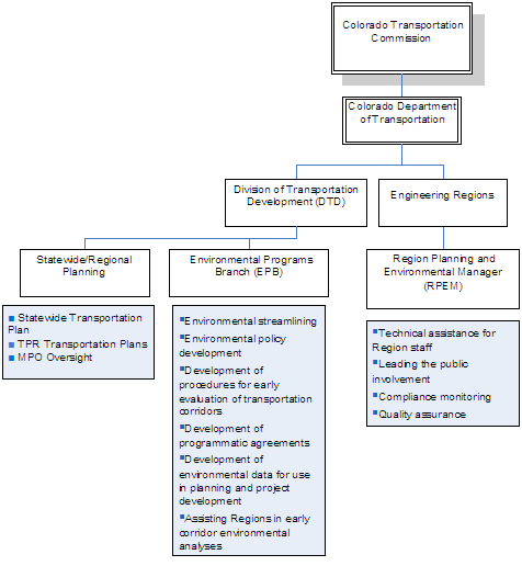
Figure 2. CDOT Decision-making Responsibilities |
|
|
Regional Decision-making Structure
CDOT Headquarters provides policy and program direction The six CDOT Engineering Regions are responsible for project development, construction, and maintenance related to environmental activities, with assistance from headquarters staff as necessary. NFRMPO is located in CDOT Engineering Region 4. The CDOT Statewide/Regional Planning Branch at Headquarters also provides MPO support. Figure 2 illustrates the decision-making responsibilities of the CDOT organizational units with respect to environmental processes.
As the MPO policy board, the Regional Planning Council leads the decision making within NFRMPO. The council comprises elected officials from each participating jurisdiction and one representative each from the Colorado Transportation Commission and the Air Quality Control Commission. Two standing committees, the Technical Advisory Committee (TAC) and the Transit Advisory Group (TAG), provide technical expertise and advice to the council. Staff from the member jurisdictions make up the committees. A management team and technical support staff guide MPO operations.
Pilot Project Structure
The STEP UP pilot program was administered by a coherent organizational structure and had an outreach component. A steering committee of staff-level representatives from CDOT, FHWA, USEPA Region 8, and NFRMPO led this project. During Phase I, work groups provided an opportunity for broader participation and enabled specific program objectives to be fully considered. During Phase I, meetings were held at least once per month involving all participating agencies. Communication was informal, using telephone calls and email. CDOT initiated and managed a consultant contract to provide project guidance and support for process and tool development.
Figure 3. Project Decision-making Structure
|
|
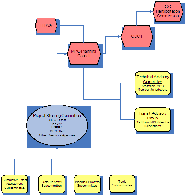
Early and continued resource agency involvement was a key component to the success of STEP UP. Each resource agency voluntarily dedicated a staff member to participate in the STEP UP meetings and provide input on the initiative. The STEP UP steering committee provided outreach to all relevant environmental agencies, including federal and state agencies with a regulatory responsibility under NEPA and a role in managing particular state resources. These agencies included the USFWS, USACE, USGS, SHPO, and CDOW. Outreach to agencies that were not part of the steering committee occurred through two stakeholder meetings in 2003 and 2004 and through presentations to specific agencies. The presentations introduced the intent of the pilot project and solicited opinions from other agency staff.
Members of the steering committee and staff from other stakeholder agencies participated in four specific work groups. Figure 4 identifies the groups and their purposes. The decisions made in these groups provided the steering committee with the information needed to design the new process. The Tools and Data Repository Work Groups provided information to the consultant for the initial design on the web-based tool and recommendations for establishing the database required for its support.
Figure 4. Work Group Structure11
| Work Group | Purpose |
|---|---|
| Planning Process | Identify and review existing transportation planning process at the state level and MPO level; critique the existing process and identify areas for modification |
| Cumulative Effects Assessment | Identify the beginnings of a methodology for the cumulative effects analysis component of the STEP UP project |
| Tools | Develop a conceptual design for a multi-user application that would support the STEP UP model planning process |
| Data Repository | Define the data content and data management needs for the tools required by the STEP UP model planning process |
Transportation Decision-making Process / Key Decisions
STEP UP provides a structure for environmental considerations within the transportation long-range planning process with links to the project development process. CDOT’s decision to implement corridor-level systems planning supports the STEP UP process. By spanning the full development of a proposed transportation improvement, STEP UP allows the early identification and consistent resolution of environmental issues.
Phase I
Beginning in July 2004 and continuing for several months, the four work groups met to develop a proposed process and initial design of an interactive tool to support decision making. The final model framework and tool were assembled during a series of five meetings between October and December of 2004. The framework emerged from collaboration of agency representatives on the steering committee and volunteers from other agencies. Agencies outside the steering committee that participated in the Phase I effort included:
- US Fish and Wildlife Service
- US Army Corp of Engineers
- University of Colorado at Denver (CU-Denver)
- Colorado Natural Heritage Program
- Middle South Platte Wetland Bank
- US Forest Service
- US Geological Survey
- Denver Regional Council of Governments
- Colorado State Historical Preservation Office
- Rocky Mountain Bird Observatory
Agencies not represented on the steering committee or in the work groups were stakeholders in the process. Although these agencies were represented during the development of STEP UP, specific participants and level of participation varied.12
STEP UP Process
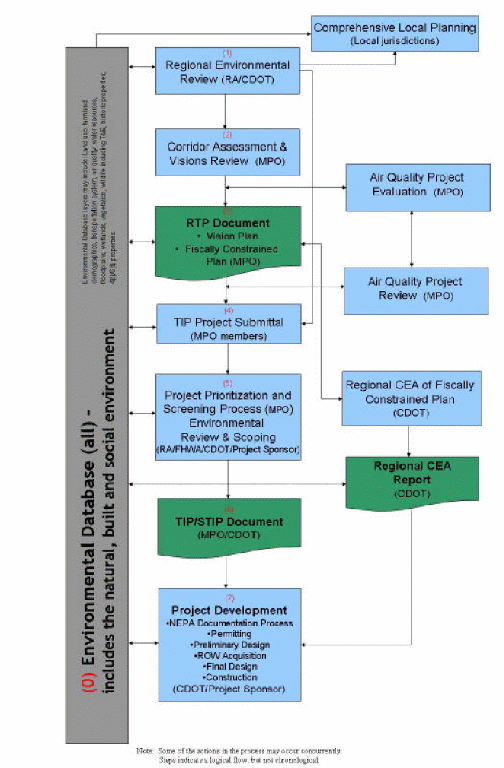
Figure 5 illustrates the STEP UP framework developed through the work group and steering committee process and provides a brief description of each step. Steps 1 through 3 of this process link to the long-range planning process for RTP development. Steps 4 through 7 tie to the development of the TIP and the environmental review process.
Figure 5. STEP UP Process
|
Step 1 – Regional Environmental Review (Resource Agencies/CDOT). Using a web-based GIS tool, resource agencies and CDOT review environmental data layers, identify critical environmental issues (including cumulative impacts) within the region, and provide online comments on corridors and their relationships to environmental resources. Step 2 – Corridor Assessment and Visions Review (MPO). MPO reviews its visions, goals, and strategies for regionally significant transportation corridors (RSCs), which reflect environmental considerations identified in step 1. Step 3 – Regional Transportation Plan Document (MPO). The MPO prepares the RTP every 4 years based on these RSCs, informed by the regional environmental review. Key elements of the RTP include: values, vision, goals, and strategies for the RTP; inventory of existing transportation system; RSCs; criteria for identifying RSCs; RSC north/south and east/west designations; and vision, goals, and strategies for the RSCs. Step 4 – Transportation Improvement Plan Project Submittal (MPO Members). MPO members submit projects that are consistent with RSCs and resource allocation priorities from the RTP for possible inclusion in the TIP. Step 5 – Project Prioritization and Screening Process (MPO) and Environmental Review and Scoping (Resource Agencies/FHWA/CDOT/Project Sponsor). The MPO evaluates and prioritizes projects based on established criteria, including environmental impacts. Early identification of cumulative and environmental issues that could affect a project’s priority, alignment, or features. Selection of transportation improvements that protect the environment, enhance quality of life, and promote community values. This step also marks the initial Project Development phase beginning with the NEPA process. Step 7 – Transportation Improvement Plan /StateTransportation Improvement Plan Document (MPO/CDOT). MPO prepares a list of projects for the next 6 years and updates the list every 4 years based on the fiscal constraints of the RTP. TIP projects integrate into the STIP for state and federal funding. Step 8 – Project Development (CDOT/Project Sponsor). Specific projects are bid, planned, and constructed. For each project selected, the NEPA process is completed, and the project designed, including NEPA documentation, permitting, preliminary design, ROW acquisition, final design, and construction. |
Web-based Technology
Design of the management application for STEP UP is another aspect of the Phase I effort. The consultant guided tool development by presenting draft versions of the tool for the stakeholders’ review and comment. The interface design was improved through participants’ concurrent review and refinement of the process steps. The result was a complete understanding of the process and the tool’s capabilities by all participants.
The management tool is a web-based GIS application. The web-based aspect provides easy access to all those involved, reducing the impact on resource agency staff's time and availability. Local jurisdictions in the MPO region have used the tool to facilitate consideration of environmental impacts with proposed land use changes. Local use of the tool will be evaluated in Phase II during the 2035 RTP development.
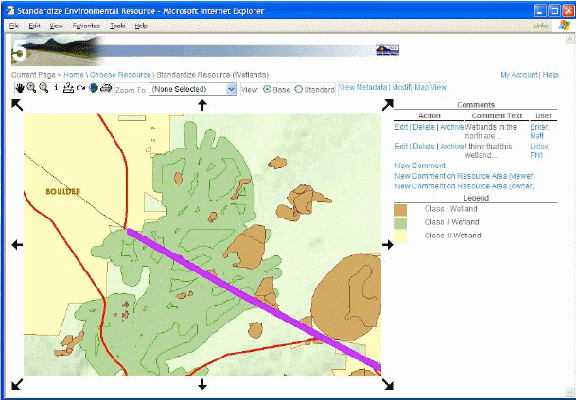
Figure 6. Screen Capture from Web-based Tool13
The management application development had three objectives:14
- Represent each process step through one or more user-friendly interfaces. These interfaces must be accessible by members and staff of planning partners and the resource agencies.
- Provide dynamic and configurable GIS mapping. Maps of environmental issues, proposed projects, and transportation planning corridors should display all key elements of the STEP UP planning process.
- Produce a reusable database of projects and environmental data. All key data input should extend or enhance the underlying GIS and relational databases so that the data produced through this application are available across planning efforts or planning cycles.
The team also determined that the tool should be constructed around ESRI’s ArcIMS and conform to CDOT’s standards for web-based implementation. For further consistency with CDOT technical standards and applications, Oracle was selected as the data management software. The resulting tool is an interactive online application that is compatible with a standard web browser and requires no proprietary software license.
To populate the database for the management application tool, data availability in the following categories was fully investigated: water resources, species of interest, geology, Section 4(f), 6(f), cultural resources, and land use.
The following table presents the level of detail of the investigation completed for the water resources data layers.15
Water Resource Layers |
||
|---|---|---|
| Layer | Source | Availability |
| Wetlands | National Wetlands Inventory – U.S. Fish & wildlife Service (USFWS) | Limited availability at 1:24,000-scale maps for most of Colorado (many are outdated) |
| Waters of the United States | National Hydrology Dataset – U.S. Geology Survey (USGS) | Small-scale data available nationwide |
| Floodplains | Federal Emergency Management Agency (FEMA) | Limited availability of digital products |
| Watersheds/Hydologic Units, including Impaired Waters | Colorado Department of Public Health and the Environment (CDPHE)/U.S. Environmental Protection Agency (EPA) | Small-sale data available nationwide – 303(d) list and TMDL list |
| Canals/Ditches | Various | No standard products available |
| Dams/Impoundments | DNR/State Engineer | Text database available |
| Riparian Vegetation | Various | No standard products available |
At the completion of Phase I, the following objectives were identified for the Phase II effort:
- Conduct a pilot program that further develops and proves the concepts behind the STEP UP processes for eventual statewide implementation.
- Support the NFRMPO in providing additional environmental review capabilities during its next RTP update.
- Formalize the STEP UP process and tools.16
Phase I of STEP UP was completed in early 2005. Participating Phase I agencies were invited to participate in Phase II. This second phase involved the application of the Phase I methodology to the 2035 RTP process.
Phase II
A November 2006 kickoff meeting initiated the Phase II effort. Staff from NFRMPO, CDOT, USFWS, CDOW, FHWA, USACE, and the SHPO participated. The purpose was to review the process for the RTP development and to identify and resolve any lingering questions and issues.17
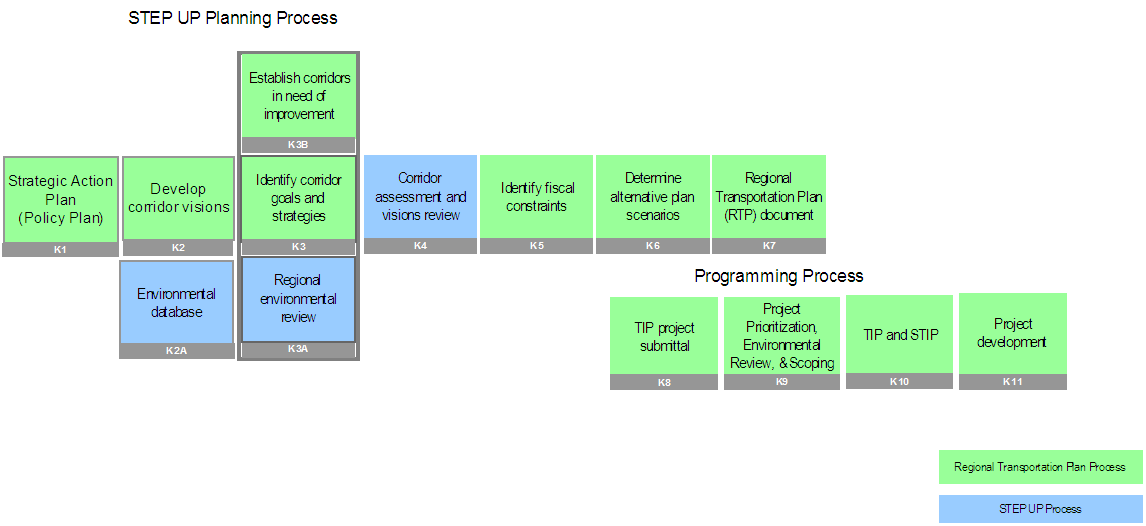
Although the STEP UP methodology provides a systematic way to introduce environmental review into the long-range planning process, significant steps in the planning process occur outside of STEP UP. These steps are necessary to determine regional socio-economic changes, identify transportation system deficiencies, and involve the public in the process. Phase II was to integrate the STEP UP individual steps into the existing RTP process so the requirements were met in an enhanced planning environment. The following graphic illustrates the RTP process with the STEP UP process included.
|
Figure 7. NFRMPO Planning Process with STEP UP |
|
|
Regional Vision
The North Frontage Range Transportation and Air Quality Planning Council has adopted Value Statements and associated implementation steps to guide the various advisory committees and MPO staff in direction, priority-setting, and implementation efforts.
The first steps in the long-range planning process involve establishing the goal and vision for performing the required analysis in support of the region’s needs. At the NFRMPO, this step has been a standard part of the planning process for many years. The Strategic Action Plan is a detailed statement of the transportation vision for the North Front Range region. This document also details steps toward implementing the vision. The Strategic Action Plan recognizes the requirement for “a consistent long-term effort in consensus-building on the part of the entire organization and a unified determination to achieve written long-term goals for the MPO.”18
The Strategic Action Plan provides Value Statements (A through F) and Propositions (1 through 7) with corresponding Key Strategies and Action Steps to accomplish the stated goal. For example, Proposition #2: Decreased Reliance on Single Occupancy Vehicles contains the following Key Strategy.
| Figure 8. Key Strategy for Proposition #2 | |
|---|---|
Key Strategy #1 |
|
By planning for and implementing effective alternative mode choices and work environments, such as carpool, vanpool, bus, commuter rail, telecommuting, and teleconferencing. |
|
Action Steps |
|
A. |
Gain MPO Planning Council direction for alternative mode choices to be provided at the regional level. |
B. |
Create a business and marketing plan for alternative mode programs for regional and local implementation (e.g., carpool and vanpool programs – SmartTrips. |
C. |
Create and maintain a regional carpool matching program. |
D. |
Create and maintain a regional vanpool program (VanGo). |
E. |
Develop a Commuter Rail strategy to implement rail solutions for the North Front Range within 20 years. |
F. |
Complete a Regional Transit Framework and Transit Element for the 20-year Regional Transportation Plan. |
The new direction for corridor planning that CDOT has provided has required the state TPRs to identify regional corridors and corresponding corridor visions. Each corridor vision includes a statement of the primary investment need along with a vision statement, goals and objectives, and implementation strategies. These stated regional goals and corridor visions guide the development of the RTP.19
Technical analysis also supports corridor review. System deficiencies are analyzed with the land use and travel demand models. The initial STEP UP process steps to establish the environmental database and conduct a regional environmental review also provide data for the corridor assessment process. Data available from the North I-25 EIS populated the tool database to develop the 2035 RTP.
In December 2006, NFRMPO and CDOT asked the resource agencies to use the web-based tool in providing their regional environmental review and for submitting comments on the RSCs. Although most comments received were general in nature, NFRMPO anticipates continuing this approach as more data become available to further develop the tool. Also, the local jurisdictions reviewed the environmental layers when proposing new transportation improvements. Using the environmental data in conjunction with land use planning may support project alternatives that are easier to fund and construct.
The STEP UP tool was used in each step of the RTP development process. In the environmental review step, the tool enables staff from resource agencies to provide specific comments regarding the environmental resources present in each corridor. This interface also provides multiple input screens for local agencies and MPO staff members to enter the required information about a project so that it can be screened and prioritized for the RTP. The input screens are individual tabs across the top of the form. The local government or other sponsoring agency will fill in the first four tabs, General, Cost, Element, and Criteria. A “score” tab works with the MPO’s prioritization process.20
The Regional Transportation Plan
CDOT first introduced the concept of RSCs in the 2025 RTP as a Key Strategy.21 Following this action, CDOT introduced the “Corridor Visioning” process in the revised Regional Transportation Planning Guidebook. To prepare for the visioning process CDOT developed, the MPO established the Regionally Significant Corridors Technical Advisory Committee (RSCTAC), comprising Technical Advisory Committee members, land use planners, and rail and aviation staff. This regional committee defined “regionally significant” and established its criteria. As a final step, the committee identified all RSCs in the North Front Range. To maximize CDOT’s resources, the MPO Planning Council has focused on projects located in these corridors. This transportation investment strategy served as the basis for decision making in the 2030 RTP.22
In the 2035 RTP, RSCs in the NFRMPO have been grouped into three tiers, with Tier I containing those corridors of greatest significance, including the I-25 Corridor. The MPO Planning Council is the decision-making body for resource allocation. Consistent with the established investment strategy, the council assigns resources to the tiers by a predetermined percentage. Within the Tier I category 70 percent of the current funding is applied to highway capacity needs. Applying funding limits on a corridor basis provides flexibility to move funds for specific projects.
‘Key Strategy’ from the 2025 Plan reads: “A network of Regionally Significant Corridors should be established based upon travel demand and connections between major North Front Range and surrounding communities and activity centers. Regional planning and transportation investments should focus on maintaining efficient, multimodal mobility along these strategic corridors.”
The NFRMPO TAC is responsible for corridor assessment and visions review. Although the TAC was not directly involved with developing STEP UP, they are using the process for the first time to consider corridor alternatives in the 2035 RTP. Environmental impacts must be considered on all capacity enhancement projects; those data are exclusively from STEP UP. Also, projects undergoing environmental review inform and update the corridor vision; for example, language from the purpose and need is added to the RTP. This step ensures future projects will remain consistent with the overall corridor vision as supported in the environmental review process.
Programming and Project Development
|
Figure 9. Programming Process |
|
|
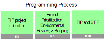
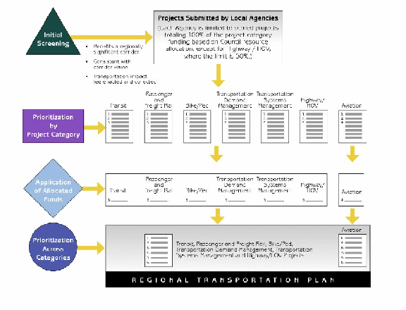
Although the STEP UP process initiates environmental review during long-range planning, environmental factors are also considered in the programming cycle and continue throughout project development. The RTP focuses on corridors, but it remains the basis for identifying specific project needs. This practice satisfies the federal requirement for fiscal constraint, and the MPO has developed a robust prioritization process to accomplish it. CDOT provides the budget to the MPO for the plan and the TIP. The MPO Planning Council then applies the prioritization process and selects projects to include in the TIP. The following graphic illustrates the process used in the 2030 RTP.
Figure 10. NFRMPO Plan Development Process for 2030 RTP23
At the final stage in the STEP UP process, project-level information developed in long-range planning with the associated costs and schedule applied during the programming phase carries forward into the environmental review process in the project development phase.
The NFRMPO’s 2035 RTP currently is being developed. The full impact of the STEP UP process will not be visible until a project identified in the long-range planning phase has moved through programming and into project development. The intent of the pilot project was to avoid the environmental obstacles that often occur during the NEPA process, when avoidance and mitigation can be costly. Whether STEP UP has achievement this goal will be assessed when the 2035 RTP is complete.
Phase III
To date, STEP UP has been applied only in the NFRMPO region. Phase III will apply early environmental review statewide using the STEP UP environmental screening tool and process. Because the pilot project was specifically for the NFRMPO, implementation at a broader level will require additional resources. Additionally, the availability of statewide data remains a significant obstacle. Nevertheless, movement toward full implementation of STEP UP in Colorado is being seriously evaluated. Other MPOs have demonstrated an interest in using the tool, and Colorado Springs has consulted with NFRMPO about its use. CDOT continues to rely on CU-Denver to develop GIS layers for environmental review.
In addition to exploring database development, CDOT has been converting its current PC application GIS software to a web-based technology, GeoMap. Version 1 of GeoMap was presented in November 2006, and CDOT is currently preparing Version 2 for release in mid-June 2008. This system has a broader application for CDOT because it interfaces with financial, scheduling, and project management systems. The intent with each version is to add functionality and increase environmental integration. This new system is based on ESRI ArcIMS, as is STEP UP, and will have many of the same features. Ultimately, all internal CDOT users, MPOs, and other stakeholders will have access. In the future, the public may have access to certain information within GeoMap.
With GeoMap, CDOT has assumed responsibility for building and maintaining a database repository. Although only 20 environmental layers are currently in the system, the intent is to add data files required for transportation analysis. Additional staff have not yet been necessary to support this application, but training for CDOT employees is ongoing.
Lessons Learned
Success Factors
Structured Decision-making Process
Both CDOT and the NFRMPO have created a structured process to support consistent long-range transportation planning. At the state level, CDOT continues regular updates of the STIP through an established cycle of regional plan updates. All TPRs are on the same update schedule, and all 15 regional plans are included in the state plan.
The NFRMPO has a rigorous project prioritization and resource allocation process. This level of consistency eliminates political influence and supports the greatest needs of the region. With this degree of standardization and funding limitations, smaller projects of local significance are unlikely to be supported at the MPO level. Efforts to seek new funding sources will be required to overcome this obstacle.
CDOT is changing at the project-planning level. The STIP is a 6-year program updated every 2 years. The STIP provides detailed cost and schedule information for those projects under construction or soon to be. At the other end of the planning spectrum is the RTP with its 20-year planning vision and fiscal constraints. CDOT has identified the need to address projects expected to be constructed in the 7- to 10-year timeframe that require more specific definition and scoping. This new mid-level process is the Mid-term Implementation Strategy (MIS). The MIS was developed during the debriefing discussions following the 2030 plan update. The perspective that the 20+-year planning horizon is too long, and the STIP too immediate, led to this new interim planning strategy. This process provides a new level of structure in long-range planning.
The corridor planning approach is a relatively new feature to transportation planning in Colorado. This approach provides the flexibility to move funding within a corridor for those projects that are ready to be advanced, avoiding delays when obstacles appear. One potential drawback to this approach is in the degree of standardization in the corridor-established vision. The goals and strategies for a corridor are selected from a standard list of options providing consistency across regions. At the project level, however, such standardization could hinder the ability to address a unique purpose and need.
Linking Planning and NEPA
Colorado has been steadily moving toward greater environmental integration in systems planning. Several initiatives have been identified at both the headquarters and regional levels to incorporate environmental awareness and environmental review. Efforts such as the Environmental Forum and the Environmental Overviews demonstrate an ongoing commitment to this process. Also, CDOT has established a statewide program for this effort, creating a Linking Planning and NEPA Coordinator position.
The effort to link planning and the NEPA process is geared toward the staff by offering training and encouraging involvement. The STEP UP effort was aimed exclusively toward decision making at the staff level with little effort toward engaging the public or elected officials. In contrast, the Environmental Overviews in Region 4 substantively involved the public and were very successful. At a regional level, the potential for “corridor protection” exists. With a planning process geared toward a corridor perspective, increasing public involvement may create an opportunity for such protection or, at a minimum, limit encroachment on identified alternatives.
The on-line training for Linking Planning and NEPA that CDOT offers is an excellent resource for understanding the process. The following information from that site specifically describes the decision-making process.
| Figure 11. The Planning and Decision-making Process |
|---|
|
The Planning and Decision-making Process Vision and Goals: These will provide the overall direction for developing transportation improvements within the state or region. These are the guiding principles that each project will be expected to fulfill. Objectives and Measures of Effectiveness: These may also be developed alongside the goals as indicators that will be applied to the plan and its products to assess the degree of their success at meeting the goals. (For example, if a Plan Goal is to “Reduce Peak Period Congestion” an Objective or Measure may be “Ensure that all state highways and interstates function at LOS D or better during peak periods.”) Corridor Vision Description: A transportation system inventory is completed to find the areas that either do not or will not meet the Plan goals, and those areas are described in terms of travel patterns, travel times, mode splits, and other transportation indicators that characterize the nature of the transportation problems at work. Specific corridors may be identified during this part of the planning process. Strategies and Alternatives: A range of transportation improvements will be considered both at the regional or statewide planning level and/or the corridor level as appropriate. The range will remain general. Each of the alternatives will be evaluated by applying the goals (or objectives and measures of effectiveness.) Public Involvement: Various outreach methods and events are utilized through development of the plan. These may be meetings, workshops, advertisements or articles in the newspaper, development of website, etc. Mitigation: SAFETEA-LU requires that transportation agencies consider to some degree the mitigation opportunities for potential impacts to communities and natural resources. |
Key Innovations
Web-based Decision-making Tool
The STEP UP process followed the example set by Florida’s Efficient Transportation Decision Making process. The decision-making tool for the STEP UP project is the closest link to that example. The interactive tool is based on agreed-upon environmental data in GIS format. The thoroughness of such a review requires the availability of accurate data.
The tool is readily accessible to all resource agencies, local jurisdictions, and planning agencies via the Internet using a standard browser. A user can review data in one or more layers and provide comments. The comments are then available to all participating users for consideration and response. The MPO has ultimate control of the site. The tool is versatile enough for other MPO regions’ use by adapting the database.
The STEP UP tool has generated sufficient interest and support that CDOT is planning to broaden its capabilities in this area. GeoMap is similar but has greater functionality for other uses within CDOT. Although GeoMap Version 1 has been used on a limited basis, supplemental contract efforts are underway to provide additional versions having greater coverage and expanded capabilities. CDOT’s commitment to this interface and identifying and securing the data necessary for its use will pave the way other STEP UP-like projects across the state. The possibility that “mini-STEP UPs” could be implemented in various regions rather than having a coordinated system available statewide is a concern because of potential data inconsistencies and duplication of effort.
Barriers Encountered and Solutions
Data Availability and Management
The largest obstacle encountered in the development of STEP UP was the availability of the necessary data to populate the tool. The issue of scale compounds the issue of data gaps. Scale is of primary concern between the long-range planning and project planning steps and is most visible when compiling data from various sources. The most consistent data sources are at the state or federal level, but these data are often not refined enough for project considerations. In contrast, very detailed data such as parcel data or species inventories are not uniformly available beyond the regional scale. Corridor-level planning attempts to bridge this scale gap. Colorado’s approach of using a corridor-level process for long-range planning will require an adjustment in all aspects of the planning process. Data availability remains an issue.
Although the STEP UP leadership team envisioned a fully populated database containing many different environmental layers and constructed to integrate seamlessly with CDOT’s information and electronic infrastructure, fulfilling this vision currently is not possible. The tool depends on a data repository, requiring full participation from the federal and state resource agencies for data, staffing, and equipment, as well as continuous funding and maintenance. Use of restricted data, as encountered during the development of STEP UP (particularly for SHPO), is another issue.
STEP UP does not include data from several sources including historic resources, additional hazardous materials data, North Front Range land use data, soil data for farmland identification, and wildlife data beyond threatened and endangered species. Even within CDOT data gaps exist. Often data are available only for the project area, and significant gaps exist even at this scale. Within the STEP UP project, data available from the North I-25 EIS helped to bridge the gap.
A champion at the state or federal level is needed to implement a statewide GIS system in Colorado. Funding for STEP UP was restricted to the North Front Range region, and thus further implementation clearly will require additional funding resources. Data management, updating, and training will also require dedicated staff and funding. Through GeoMap, CDOT is making progress in this direction. Further support by CU-Denver also could help solidify the full implementation of this tool.
Need for Education and Understanding
A consistent comment from the project participants was the ongoing need for education and understanding of the planning process, NEPA, and roles and responsibilities. At the outset of the STEP UP meetings, few planning group members were well versed in both NEPA and transportation planning processes. The resource agencies did not understand the planning process, and the MPOs did not understand the resource agencies’ responsibilities. Before the STEP UP process began, some participating organizations had seldom worked collaboratively. Much time was spent at the beginning of the project establishing a common understanding. The consequence was frustration at the slow progress of the project. Without a clear understanding of both processes, the value of the time spent in process development and in environmental review at the systems level is difficult to discern. Such an understanding, however, is crucial for dedicating resources and ensuring ongoing collaboration. Personnel changes at CDOT, FHWA, and some of the resource agencies also were barriers. With the initial project sponsors removed, keeping the vision in perspective was often challenging.
Three goals for future efforts of this type were identified:
- Clearly articulate the broader goals from the outset so that the vision is preserved even though the individuals involved change;
- Provide an understanding of agency roles and responsibilities so that expectations can be managed, predictability in the process can be ensured, and the most accurate data available can be included; and
- Establish deadlines and potential payoff for resource agencies. Knowledge of the process is not sufficient incentive for agency participation. An observable gain must be evident for this process to be of value.
Endnotes
2 CDOT Environmental Stewardship Guide v2, May 2005
3 Colorado Conservation and Transportation Planning Workshop Final Report, 2006, http://www.defenders.org/programs_and_policy/habitat_conservation/habitat_and_highways/resources/colorado_conservation_and_transportation_planning_workshop.php
5 North Front Range 2035 Regional Transportation Plan, Introduction, D. Other Studies, p. 7-8.
6 Final Phase I Report, Chapter 1
7 Consultant services provided by Carter and Burgess, Inc
8 Phase II Report p.1
9 Final Phase I Report, Chapter 2, p. 11
10 Environmental Streamlining on the STEP UP Project, TRB Conference, September 11-14, 2005
11 Final Phase I Report, Appendix A, p. A-1 – A-2
12 Final Phase I Report, Chapter 5, p. 33
13 Phase I Final Report, Chapter 5, p. 37
14 Phase I Final Report, Chapter 5, p. 33
15 Ibid, Chapter 6, p. 46
16 Phase II Report, Introduction, p. 1
17 Ibid.
18 Strategic Action Plan, NFRMPO, December 2003, p. 1
19 NFR 2030 Regional Transportation Plan, Appendix D, Corridor Visions
20 Phase I Final Report, Chapter, p. 39-43
21 Regionally Significant Corridors, NFRMPO, August 2003, p. 3
22 Regionally Significant Corridors, NFRMPO, August 2003, p. 4
23 2030 Regional Transportation Plan, Chapter 1, p. 6