
Whitewater Canal Scenic Byway
All Photos (9)
-

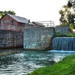
The Whitewater Canal flows through the stone walls of Lock #25 powering the 120-year-old Metamora Grist Mill while water tumbles over the adjacent waste wier (overflow channel). This is one of many original structures of the historic canal to explore along the Whitewater Canal Scenic Byway.
Public Domain. Whitewater Canal State Historic Site
-
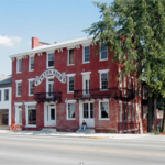
The Vinton House, built in 1847 faces the Old National Road, US 40, in Cambridge City. The facade of the three-story, red-brick building is lined with three rows of six windows across the top, four windows and two double doors with balconies in the middle row, and two display windows, two double doors and two double-hung windows on the street level. On the right side is a hardwood tree with green leaves of summer that towers over the building and provides shade from afternoon sun.
Public Domain. Phyllis Mattheis
Download Original (1104 x 828 pixels, 1729.9 MB)
-
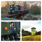
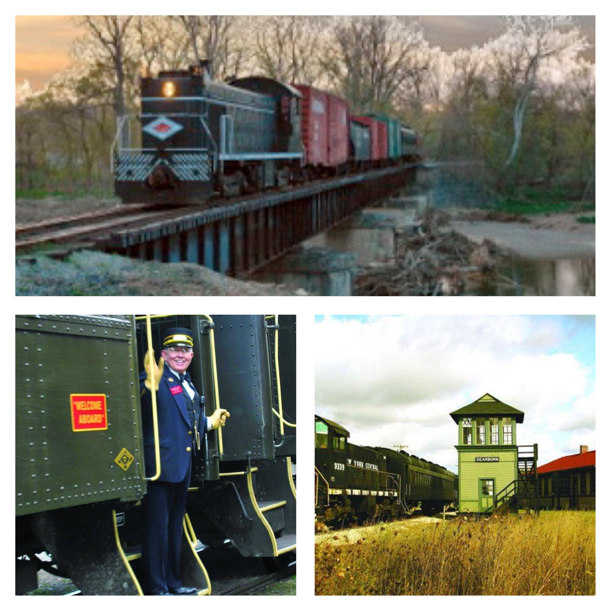
A picture collage of the Whitewater Valley Railroad includes a horizontal image across the top showing the excursion train crossing a metal trestle perched atop 3 stone pilings built in the Whitewater River-West Fork. The jet black engine, with its light on, is pulling five cars in the springtime as the blooming trees catch the evening sun.
The image on the lower right shows the excursion train’s jet black engine pulling a string of historic cars past the reconstructed, two-story, green-siding clad Dearborn Crossing switching tower and the refurbished Rushville Depot with its green siding and bright red roof. Both were relocated to this historic site.
On the lower left is a picture of an older gentleman serving as a train conductor. He is standing on the bottom step of a railroad car greeting riders. The green rail car next to him has a red sign, trimmed in a gold band emblazoned with “Welcome Aboard.” The rail car behind him is a jet black passenger car. Both cars have bright yellow handles and framed steps for passenger safety.Public Domain. Whitewater Valley Railroad
Download Original (2048 x 2048 pixels, 807.7 KB)
-
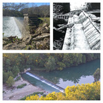
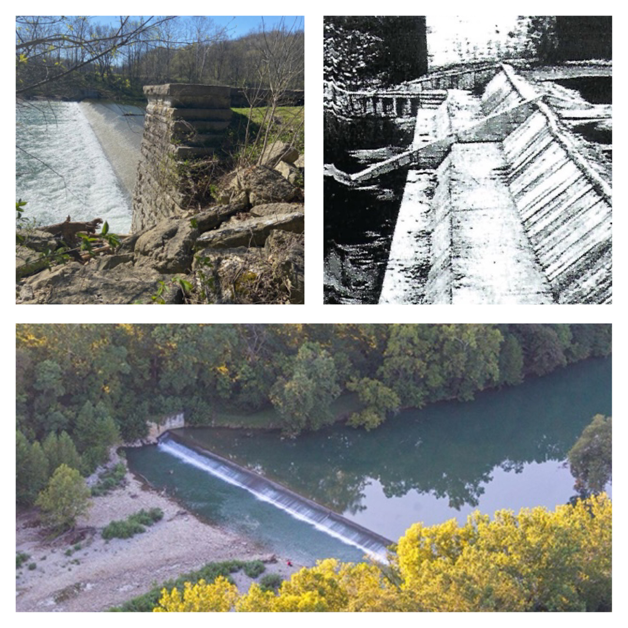
The Laurel Feeder Dam or Dam #4 is represented by three images in a collage.
The image in the upper left shows a picture taken from the overflow side of the dam with whitewater cascading over the 8-foot high cement dam that stretches across the Whitewater River. In the foreground is a limestone block pillar which frames the dam and secures the intake or “regulator“ gate to supply water to the canal. (photo courtesy of Candy Yurcak)
The square image on the upper right shows a much earlier version of the dam when it was built of three cascading levels of wood. In this black and white historic image, pre-1940, there is no water flowing over the dam. (photo courtesy of Indiana Department of Conservation)
The lower horizontal image is an aerial shot of the feeder dam showing the Whitewater River flowing over the 372’ wide dam at dusk making a white ribbon across the tree-lined river.Public Domain. Scott Richardson
Download Original (2048 x 2048 pixels, 1010.0 MB)
-
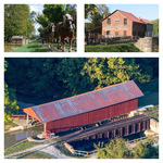
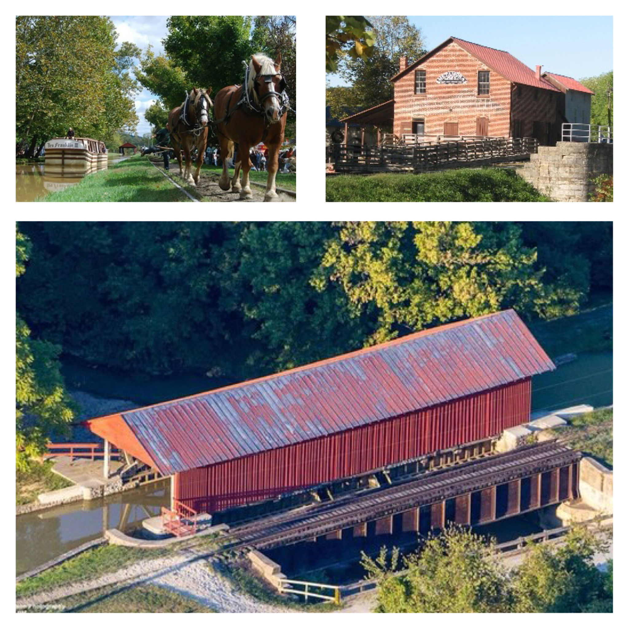
The Whitewater Canal State Historic Site includes three main features that are in this picture collage.
The square image in the upper left shows a reconstructed canal boat, Ben Franklin III, being pulled up the canal by a team of two brown-colored draft horses walking between the steel rails on the original towpath. Off in the distance is the Duck Creek Aqueduct downstream from the boat. On this sunny, cloud-filled day, people are milling along Pennington Road on the south side of the canal. (photo courtesy of Ron Yurcak)
The square image on the upper right shows the red brick, Metamora Grist Mill, built in 1899 to replace an earlier mill that burned down. The two-story mill is flanked by the street on the south side and the stone canal lock, canal race, and water wheel on the north side with wooden ramps providing visitors access to the water works. (photo courtesy of Paul Baudendistel)
The lower horizontal image is an aerial shot of the 70’ long wooden, covered aqueduct channeling the canal across Duck Creek 16’ below. In the afternoon sun, the mottled red paint on the metal roof covers the canal channel with the south side clad in red vertical wood siding, while the north side is open framed. The railroad tracks and train trestle lie alongside the aqueduct on the canal’s original towpath. This is the only original wooden covered aqueduct in the country and is both a National Civil Engineering Landmark and is on the National Register of Historic Places.Public Domain. Scott Richardson
Download Original (2048 x 2048 pixels, 1158.2 MB)
-
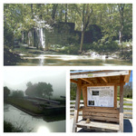
A collage of three images of the Whitewater Canal Trail includes a horizontal image across the top along the Metamora Trail. Here the canal water flows through the 12’ high stone walls of Lock #23. Now surrounded by forest, this lock and Lock #22 just 400’ downstream from this site are called Twin Locks. (photo courtesy of Paul Baudendistel)
The image on the lower right shows the wood-constructed wayfinding kiosk at the Laurel Trailhead on a sunny spring day with the budding trees lining the trail. The station, adjacent to the trail on a paved waystation, provides a detailed map and pictures of the entire Whitewater Canal Trail system on the metal-roofed kiosk wall and a bench in front for hikers to rest. (photo courtesy of Candy Yurcak)
On the lower left is a image of the upstream side of Lock#24, Gordon’s Lock, at sunrise. The lock has been reconstructed and regulates the water in the canal race of the state historic site. The fog rises around the canal works muting the tree-covered hills in the distance while sunlight glistens off the canal water in the foreground. foreground.
(photo courtesy of Candy Yurcak)Public Domain. Paul Baudendistel, Candy Yurcak
Download Original (2048 x 2048 pixels, 855.3 KB)
-
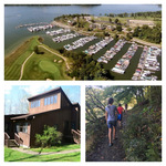
A collage of three pictures shows the range of recreational opportunities in the Brookville Lake-Whitewater Memorial State Park Complex.
The horizontal image across the top is an aerial photo of Kent’s Harbor and Marina along the east side of Brookville Lake with open water on the west and north sides of the small peninsula. In the foreground is the two-tiered green of Hole #5 of Harbor Links Golf Course, designed by Pete Dye. Across the cart trail is the tee box and fairway for Hole #6 lining the lakeshore. Adjacent to the course is the deep-water harbor with 380 slips providing full service docking for jet skis, motor boats, pontoon boats, and house boats for owners and renters. Across the harbor are four matching structures with one for the golf club and restaurant as well as three multi-story condo units overlooking the marina. Behind them is the paved parking lot and boat storage building. (photo courtesy of Kent’s Harbor)
In the image on the lower right, an adult and three children hike one of the many dirt-covered nature trails that wind throughout the lake-park complex. The trees’ canopy provides shaded walking in the summer and explodes with color in autumn. (photo courtesy of Candy Yurcak)
On the lower left is a picture of a guest cabin at Whitewater Memorial State Park on a sunny early spring day. The brown painted, wood cabin is tucked among the beautiful woodlands with bright green grass at its two entry doors. The rustic, yet contemporary-styled cabin has skylight windows facing the sun allowing light to stream into the cabin’s second-story. (photo courtesy of Paul Baudendistel)Public Domain. Kent’s Harbor, Paul Baudendistel, Candy Yurcak
Download Original (2048 x 2048 pixels, 988.0 KB)
-
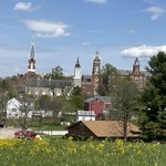
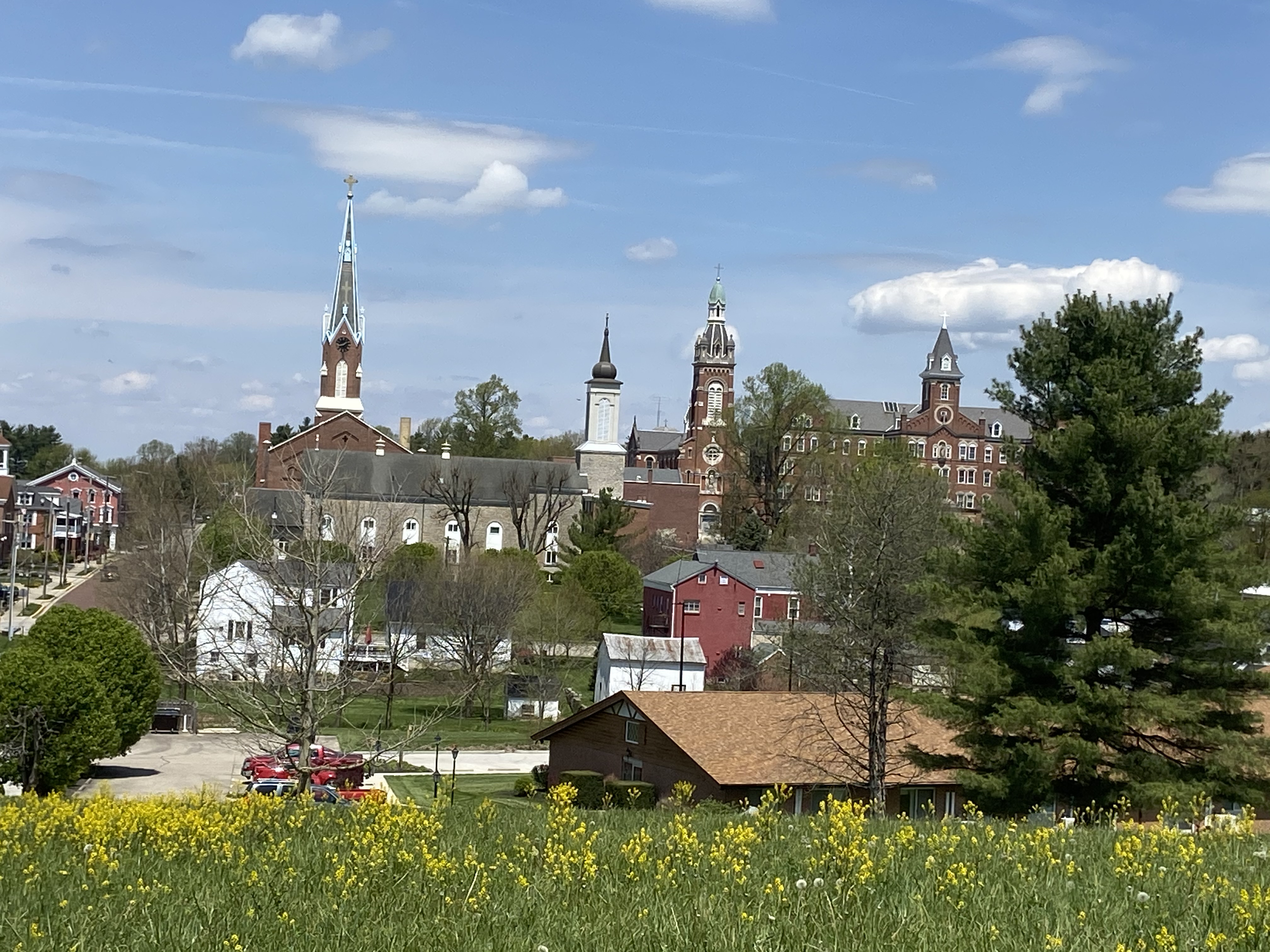
This picture shows four towering church spires painted on a cloud dappled blue sky with yellow flowers in the foreground. These steeples punctuate the rural skyline and inspire Oldenburg’s nickname, Village of Spires. The town’s strasses (streets) are lined with historic brick homes and commercial buildings. The frontmost significant structure is the Old Stone Church constructed of local limestone and topped with a reconstructed onion-domed spire called a Zweibelturm. Behind and transversally situated is the red brick Holy Family Catholic Church, the Gothic Revival parish church built in 1862 with the tallest spire, at a soaring 187’. Across from Holy Family and just a little east are the twin spires of the Baroque-style Convent Chapel and the Victorian-Romanesque-style Immaculate Conception Convent. (photo courtesy of Candy Yurcak)
Public Domain. Candy Yurcak
Download Original (4032 x 3024 pixels, 2168.6 MB)
-
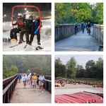
A picture collage of four images shows a sample of the many outdoor recreational opportunities for visitors in the Whitewater River Valley.
In the upper left, two young skiers and another snowboarder ride up the ski lift to the top of the slopes for nighttime skiing at Perfect North Slopes near Lawrenceburg. Behind them, the snow covered ski runs are lit up and filled with skiers enjoying the unexpected hills of southeastern Indiana. (photo courtesy of Perfect North Slopes)
In the upper right, on a cool summer morning, bicyclists with colorful helmets cross the treelined bridge in Richmond along the Cardinal Greenway, Indiana’s longest bike rail-trail constructed on the former Chesapeake & Ohio Railway. The decorative bridge, with its wooden side spindles and metal arches, crosses near Thistlethwaite Falls over the Whitewater River East Fork. (photo courtesy of Richmond/Wayne County Visitors Bureau)
In the foreground of the image on the lower right, rows and rows of red-bottomed canoes lay face down waiting to be used by canoeists. Across the paved lot, 70-80 life-jacket clad enthusiasts hold their yellow paddles as they prepare to grab their canoes and launch them down the scenic Whitewater River. (photo courtesy of Green Acres Canoe Rental)
On the lower left, ten adult hikers cross a long, ten-foot wide bridge through the Whitewater Gorge Park in Richmond, Indiana on a cool and foggy morning. On a Byway-sponsored Whitewater Walk, these hikers walked the gorge trail 3-1/2 miles through Richmond, accessible to hikers and cyclists. The 100-acre park and ranges from 200-300 feet wide and 50-80 feet deep cut by the Whitewater River’s East Fork. (photo courtesy of Paul Baudendistel)Public Domain. Perfect North Slopes, Richmond/Wayne County Visitors Bureau, Green Acres Canoe Rental, Paul Baudendistel
Download Original (2048 x 2048 pixels, 948.7 KB)