US Department of Transportation
FHWA PlanWorks: Better Planning, Better Projects
Planning for Multimodal Accessibility at the Lynnwood Transit Center
Washington Department of Transportation
- By 2023, Sound Transit will extend light rail service north from Seattle to the Lynnwood Transit Center.
- With nearly 18,000 daily boardings and limited parking at the station, Sound Transit expects approximately 85% of riders to arrive by transit, biking, or walking.
- The Lynnwood Multimodal Accessibility Plan helped WSDOT understand how strategies that improve station area accessibility and light rail ridership also support improvements to corridor–level performance on state highways.
- The strategies recommended in the plan would increase ridership by approximately 5,000 daily riders.
- Increased ridership would result in a reduction of 2,325 trips, or 20,100 vehicle miles traveled on the I–5 corridor.
Executive Summary
The Lynnwood Transit Center Multimodal Accessibility Plan (LMAP), completed in November 2016, recommends strategies to increase ridership at the Lynnwood light rail station, opening in 2023. Maximizing light rail ridership helps the city achieve its land use and economic development goals, the light rail agency achieve its operating goals, and state and regional transportation agencies achieve their mode shift and greenhouse gas emission reduction goals. The Washington Department of Transportation (WSDOT) also used the planning effort to pilot the use of non–traditional performance measures and a planning–level greenhouse gas analysis approach that it could use for similar future studies.
WSDOT's consultant team, led by Fehr & Peers, used the Performance Measures for Highway Capacity Decision–Making SHRP2 product as a framework for selecting performance measures for LMAP. The selected measures demonstrated how strategies that improve station area accessibility and light rail ridership also support the reduction of vehicle trips and vehicle miles traveled in the region.
The consultant team also used the Incorporating Greenhouse Gas Emissions into the Collaborative Decision–Making Framework SHRP2 product to complete a planning level analysis of how strategies proposed in LMAP would affect greenhouse gas emissions. By helping shift trips from driving to transit, the recommended strategies would result in a small reduction in greenhouse gas and criteria pollutant emissions. Using this approach in future planning studies could help WSDOT understand how planning recommendations could contribute toward meeting the state's goal to reduce greenhouse gas emissions and achieve regional air quality goals.
WSDOT's Challenge
By 2023, Sound Transit will extend light rail service north from Seattle to the Lynnwood Transit Center. This provides a once–in–a–generation opportunity to transform the area around the station from a congested, car–centric throughway to a community hub that connects residents and businesses to other regional destinations through transit, biking, and walking. The Lynnwood station will be the busiest of the new light rail line, with nearly 18,000 boardings daily. Due to limited parking, Sound Transit expects approximately 85% of riders to arrive by transit, biking, or walking. The Interurban Regional Trail, a 24–mile multiuse regional trail, and Community Transit serves the station.
Complementing Sound Transit's light rail plan, the Puget Sound Regional Council (PSRC) designated Lynnwood as a regional growth center. The City Center north of the station will accommodate significant population and employment growth. The City projects 6.6 million square feet of new development in this area, including nearly 3,000 new housing units and 9,000 new jobs by 2032.
I–5 is the primary north–south highway through the area carrying 171,000 vehicles daily (2015). The I–5 corridor has limited person throughput and reliability for auto and transit users due to traffic congestion in both the general purpose and High Occupancy Vehicle (HOV) lanes. WSDOT owns part of the Lynnwood Transit Center and a direct access ramp to and from I–5 that supports HOV and transit users. I–5 bisects the pedestrian catchment area for the Lynnwood Transit Center and the underpass at State Route 524 (44th St) is the gateway to Lynnwood's City Center.
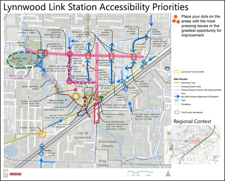
Figure 1: Map of Lynwood Link Station accessibility priorities
WSDOT initiated this study for two purposes: (1) to support safe, balanced, and efficient multimodal access to the Lynnwood Transit Center that adequately serves future transit ridership and (2) to recommend an analytical framework and decision making process for WSDOT to use for similar studies. WSDOT was particularly interested in exploring multimodal performance measures that could relate local accessibility improvements to corridor–level performance on state highways and evaluating what data and tools would best support a planning–level analysis of greenhouse gas emissions in the corridor.
WSDOT partnered with the City of Lynnwood, Sound Transit, Community Transit, and PSRC on a $300,000 multimodal accessibility plan to reduce growing travel demand on I–5 and transportation–related greenhouse gas emissions by increasing auto, transit, bicycle, and pedestrian accessibility to the Lynnwood Transit Center and future light rail station. The planning effort began in July 2015 and was completed by October 2016.
Product Implementation
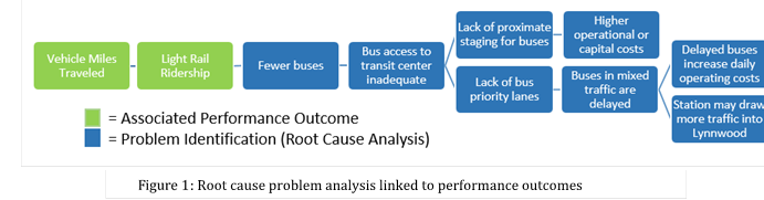
WSDOT contracted with Fehr & Peers in December 2015 to complete the LMAP. The consultant team reviewed the Performance Measures for Highway Capacity Decision–Making SHRP2 product early in the process and found it provided helpful guidance on what constituted an effective measure and how to measure performance in different decision making contexts. Fehr & Peers then used the SHRP2 product and WSDOT's Practical Solutions approach to brainstorm problems the planning effort could address and categorize them by the SHRP2 performance factors (e.g. mobility, accessibility, climate change, and land use). WSDOT used this information to build a root cause analysis linking the problems identified by the group to station area performance outcomes such as light rail ridership and corridor level performance outcomes (e.g., vehicle miles traveled). For example, Figure 1 illustrates a root cause analysis for one line of problems related to bus access to the transit center.
The LMAP also employed SHRP2's Incorporating Greenhouse Gas Emissions into the Collaborative Decision–Making Framework product during the planning process. The consultant team found the analysis steps and key questions outlined in this product very helpful. Working through this exercise with WSDOT helped the consultant team narrow the choices for the greenhouse gas performance metric to use in the analysis. The SHRP2 product did not recommend a specific measure tailored to analyzing the impact of station–area access on corridor–level greenhouse gas emissions. Instead, the consultant team used the guidance to recommend a measurement approach that fit within the existing analytical frameworks used by WSDOT and PSRC. The consultant team decided to measure the greenhouse gas emission impacts of the LMAP in terms of the emissions avoided due to transit. WSDOT uses this measure in its annual Corridor Capacity Report , which provides a variety of performance measures for urban commute corridors.
This measure is calculated as:
Emissions avoided due to transit = transit ridership * mode shift factor * trip length * emissions factor
The consultant team used the mode shift factors in the APTA Recommended Practice for Quantifying Greenhouse Gas Emissions from Transit and worked with PSRC to develop the emissions factor.
Stakeholder Collaboration
WSDOT formed an interagency advisory group in July 2015 to guide the LMAP. The group included representatives of the City of Lynnwood, Sound Transit, Community Transit, PSRC, WSDOT, and the Federal Highway Administration. The interagency advisory group met seven times from July 2015 to September 2016.
The consultant team also conducted interviews with key stakeholders, including the City of Lynnwood, Community Transit, Sound Transit, and Verdant Health Commission. An internal WSDOT team provided technical expertise and support to the planning effort.
Figure 2: Map summarizing stakeholder accessibility priorities for Lynwood Link Station
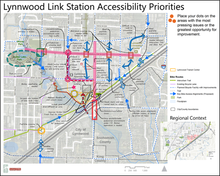
The consultant team participated in a number of community events to increase project awareness and solicit feedback, including an Interurban Trail Improvements Public Meeting, Healthy Communities Actions Plan Stakeholder Meeting, Feet First Walk and Talk sponsored by Verdant Health Commission, the City of Lynnwood Project Open House, and the City of Lynnwood Joint Board and Commission meeting. The map in Figure 2 depicts a summary of public input. These outreach efforts indicated the city needed improved pedestrian environments along 44th Ave W under I–5, along Scriber Creek Trail and the Interurban Trail, and they needed more direct walkways. Along with wider sidewalks along key roadways, the community also expressed desire for improved bicycle facilities and connections to reach the transit center. The LMAP addressed these community priorities in the development of plan strategies.
Key Outcomes
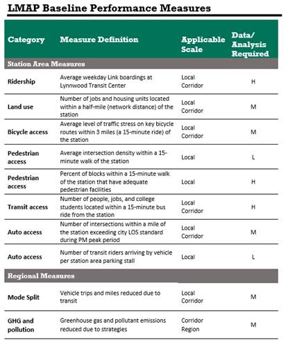
One of the key outcomes of this planning effort was linking local station–area performance to regional corridor performance measures more commonly used by WSDOT. Figure 3 summarizes the baseline measures included in the plan. The plan also evaluated a set of qualitative measures not included in the table.
Figure 3: List of LMAP baseline performance measures
The plan evaluated a bundle of recommended strategies against two other scenarios: existing conditions and 2035 baseline. The 2035 baseline scenario was based on projects assumed complete in the Sound Transit Lynnwood Link Extension Environmental Impact Statement (EIS) and projects planned by the city for implementation in the next six years.
The recommended strategies increased ridership at the station by approximately 5,000 daily riders compared to the 2035 baseline. This increase was primarily due to strategies supporting higher population and employment growth (72 percent), with approximately 20 percent attributed to non–motorized improvements and 8 percent due to improved transit access.
The analysis estimated this increase in ridership would result in a reduction of 2,325 trips or 20,100 vehicle miles traveled in the corridor. By helping shift trips from driving to transit, the recommended strategies also reduce greenhouse gas and criteria pollutant emissions. The incremental reduction in emissions due to the recommended strategies equate to less than a one percent reduction below I–5 corridor–level greenhouse gas emissions from passenger vehicles. This is not surprising given the localized nature of the LMAP strategies compared to total travel along the I–5 corridor.
Lessons Learned
WSDOT found that measuring accessibility in the context of this study brought them closer to evaluating what communities care about—connecting the concept of mobility to economic and social opportunities. Accessibility measures helped WSDOT understand how improving light rail ridership, transit access to the light rail station, non–motorized improvements, and population and employment growth in Lynnwood's City Center support state highway corridor trip and emission reduction goals.
Feedback solicited from stakeholders after the plan was complete indicated:
- The selected performance measures reflected their agency's goals
- The planning effort demonstrated WSDOT is evolving to become more multimodal
- The plan helped the City identify specific strategies and focus areas to increase non–automobile mode share downtown
- The plan helped Sound Transit identify opportunities to collaborate with other agencies to improve accessibility to Lynnwood Transit Center over a larger scale than they would have done otherwise
Next Steps
WSDOT will:
- Provide links to Performance Measures for Highway Capacity Decision–Making and Incorporating Greenhouse Gas Emissions into the Collaborative Decision–Making Framework in its training resources.
- Work with partners to develop a broader performance framework that redefines mobility, addresses all state transportation policy goals, demonstrates sensitivity to context, and reflects community preferences.
- Develop guidance for using mobility and accessibility performance measures, recommend methodologies, and tools, as well as develop a plan to secure resources to deploy those tools.
Connections to PlanWorks
Decision Guide: Corridor Planning 5 (Approve Evaluation Criteria, Methods and Measures)
Application: Greenhouse Gas Emissions and Performance Measures
The PlanWorks key decision "Approve Evaluation Criteria, Methods and Measures (COR–5)" was most relevant to this planning effort. One of WSDOT's goals for this process was to explore evaluation criteria, methods and measures that could help evaluate which multimodal strategies best supported the needs identified by WSDOT with its partners. The needs identified by WSDOT and city staff, stakeholders, and citizens for this planning effort included:
- Improving auto, bus, pedestrian, and bicycle access by identifying multimodal improvement connections to the Lynnwood City Center, Transit Center, and the Interurban Regional Trail
- Supporting the City Center Plan to facilitate a dense and walkable urban center
- Leveraging WSDOT assets to further transit oriented development
- Identifying barriers to safe, efficient, multimodal travel, with consideration for people with special needs and economically disadvantaged populations
- Enhancing the community and environment while improving the resiliency of critical transportation facilities
- Reducing growing travel demand on I–5
- Reducing transportation–related greenhouse gas emissions
The group agreed increasing ridership on the new light rail line was the baseline need, or the primary reason the project was proposed. The consultant team used the PlanWorks Performance Measures Application to provide a framework for selecting performance measures that addressed identified needs and could be linked quantitatively to ridership. These included:
Station–area measures that captured the factors that determine ridership (i.e., land use and access by different travel modes) and
Regional measures that assessed how changes in ridership will affect travel along the I–5 corridor connecting Lynnwood to Seattle.
The group also agreed on contextual measures that addressed community needs identified by stakeholders, but were either not quantifiable or not directly related to ridership.
The consultant team also used the PlanWorks Greenhouse Gas Emissions Application to complete a planning–level analysis of how strategies proposed in the Lynnwood Transit Center Multimodal Accessibility Plan would affect greenhouse gas emissions in the corridor. A key challenge for the project was to assess how strategies making it easier to reach the new light rail station would affect ridership, displace vehicle trips, and reduce greenhouse gas emissions. The consultant team started by reviewing the SHRP2 project report Incorporating Greenhouse Gas Emissions into the Collaborative Decision–Making Process and FHWA's A Performance–Based Approach to Addressing Greenhouse Gas Emissions through Transportation Planning and Handbook for Estimating Transportation Greenhouse Gases for Integration into the Planning Process. While none of these resources identified a specific greenhouse gas performance measure tailored to analyzing the impact of station–area access on corridor–level greenhouse gas emissions, they did identify factors to consider when selecting measures. Additionally, the SHRP2 report outlined 13 key questions the consultant team used to select a greenhouse gas performance measure.
For More Information
Contacts
Karena HouserPlanning Innovations Manager
Multimodal Planning Division
WSDOT
(360)705–7876
houserk@wsdot.wa.gov Reena Mathews
Transportation Specialist
FHWA Office of Planning
(202)366–2076
reena.mathews@dot.gov
Resources
- Lynnwood Transit Center Multimodal Accessibility Plan