
US Department of Transportation
FHWA PlanWorks: Better Planning, Better Projects
Integrating Freight Considerations into Highway Capacity Planning Process
Tennessee Department of Transportation
Executive Summary
-
The main contributing factors towards truck parking utilization were found to be:
- truck volume;
- on/off– ramp violations;
- higher average speeds of trucks passing the rest area; and
- presence of a two–lane roadway adjacent to the rest area.
- On truck–heavy corridors, the travel time variation (TTV) across the hours of day shows two peaks indicating more variation of travel time (less reliability) during AM and PM peak hours with off–peak hours being the most reliable.
-
The project provided three recommendations:
- Use of web–based dash–boards showing planned improvements will facilitate public and private sector engagement
- Development of a process to integrate corridor management challenges into the Freight Advisory Committee (FAC) recommendations, and
- Incorporation of data driven recommendations into corridor improvement projects.
With availability of newer data sources, State Departments of Transportation (State DOTs) are interested in developing performance– based measures for possible considerations in decision making. Freight movement is a key priority in Tennessee, because large volumes of goods are transported throughout the State. Three performance measures were used in this project: (a) efficient truck parking; (b) freight corridor reliability; and (c) freight and land use integration. This study used three products within the SHRP2 Planning Process Bundle (C02, C08, and C15) as well as PlanWorks to accomplish project goals. Key lessons that the team learned from the project were:
- The State needs to pay specific attention to truck parking because during peak hours most of the rest areas are full and drivers look to park in undesignated areas.
- Reliability of corridors shows variation in travel time during recurring and non–recurring events for freight travel. If the State provides such information ahead of time it will help drivers to choose alternate routes.
- It is critical for the State to understand land use patterns to determine the amount of freight generated and attracted in the area.
In the PlanWorks component of the project used various features such as the decision guide, assessments, and applications. The goal was to form a vision plan, and a stakeholder team to formulate the next steps of improvement for I–40 corridor in Memphis metro area. PlanWorks is made accessible as an integrated web–based resource designed primarily for the practitioners that identifies the key decision points in four phases of transportation decision–making: long range transportation planning, corridor planning, programming, and environmental review and permitting. In this project TDOT attempted to tap into the resources of corridor and long–range transportation planning to recommend various steps in forming an I–40 corridor visioning plan.
Agency's Challenge
Tennessee is a strategic location for freight distribution for the nation with over 60% of total truck traffic originating from and/or destined to outside of the State. In addition to truck throughput, the presence of five Class I railroads, the FedEx hub, and the fourth largest inland port supports the global distribution market and the national economy. The "Volunteer State" is one of two States (the other being Missouri) that is bordered by eight States (Arkansas, Mississippi, Kentucky, North Carolina, Alabama, Georgia, Missouri, and Virginia). This provides opportunities for multi–State corridor planning as well as corridor operational collaboration with their adjoining partners. Freight is a large component of Tennessee's transportation system and to address this issue, TDOT is beginning the next phase of its update to its state–of–the–art Tennessee Travel Demand Model (TDM) with specific emphasis on commodity freight movement. TDOT has also formed a data hub encompassing GPS probe data for passenger cars and trucks, and other socio–economic, demographic, and economic information to assist data driven decision making.
TDOT recently established one of the first offices in the United States dedicated to monitoring land use changes and investments that effect the regional transportation network with cooperation from other transportation planning agencies in the State. From a freight planning perspective, TDOT is in the process of developing its statewide freight demand model with assistance and support from its Freight Advisory Committees (FACs) members. The travel demand model update includes a commodity flow analysis component and will assist in the State Freight Plan efforts, which will lead into project implementation. Tennessee has four regional FACs, and one statewide FAC for freight planning assistance. Each regional FAC meets quarterly to discuss the progress in their respective region, while the statewide FAC meets once in a year to summarize, evaluate, and establish an approach for future freight capacity planning.
Additionally, TDOT is in the process of conducting a high–level assessment of truck parking in the State. The State is already in the process of analyzing available truck parking location information (estimated to be more than 200 locations) along the State's Interstate Highways. They will be estimating the saturation of available parking along the corridors using a ratio of volume and parking locations per roadway segment.
TDOT is also now studying the freight analysis with traffic operations. With the help of the Tennessee Office of Operations they plan to routinely report operations activities. The planning process is also integrated with the Tennessee Department of Safety. They seek to answer the question about how roadway corridor reliability is being affected as urban areas experience recurring and non–recurring congestion. Drivers use truck GPS data to determine truck corridor reliability and to use alternate paths during congestion.
Product Implementation
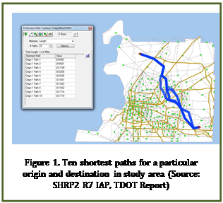
Figure 1. Ten shortest paths for a particular origin and destination in study area (Source: SHRP2 R7 IAP, TDOT Report)
I–40 in Tennessee is a freight centric corridor with number of new and emerging initiatives at local, state, and national levels. TDOT developed a new strategic PlanWorks approach to address "Freight Corridor Visioning" and further strengthen freight movement along the I–40 corridor. TDOT's PlanWorks Round 7 Implementation Assistance Program (IAP) funding assisted with improving stakeholder dialogue and collaboration in the decision–making process with respect to identifying private sector expectations for corridor reliability verses public sector funding realities in the context of I–40 strategic corridor. To support Freight Corridor Visioning TDOT sought to develop a web–tool to assist stakeholder collaboration and select performance measures to address freight movement along the I–40 corridor. TDOT maintains several real–time data sources which will be used to calculate the performance measures such as delay, travel time, travel time reliability, traffic crash, and incidents. TDOT and its partners have experience in developing freight performance measures. These results can then be summarized and provided to the private stakeholders and users of I–40 corridor. TDOT proposed developing a website to disseminate this information.
TDOT elected to use two performance measures: Expected travel time and Travel time reliability (Standard deviation, 95th percentile of expected travel time). Travel time data was collected by path, vehicle class (autos, trucks), time of day, incident type, and number of vehicles involved among other things. In addition TDOT explored the use of archive data from ATRI/NPMRDS/E–TRIMS and Real time data from sources such as WAZE.
For each origin–destination (OD) pair, TDOT sought to select the set of the shortest paths from origin to destination (see Figure 1). For this the number of shortest paths for a given OD pair is defined, OD pairs are defined as centroids of census tracts within the study area, and paths are considered unique if any link is not common to both paths
This will allow a selection of primary and alternate routes, in case of congestion, construction, or unsuitable infrastructure (such as low clearance) for special loads. Each path will be evaluated according to several performance measures to allow users to make more informed routing decisions.
As part of SHRP2–R5 effort this section explains how TDOT implemented three performance measures for integrating freight considerations into highway capacity planning process.
Efficient truck parking: Trucks carry more than 80% of freight tonnage in the United States. A mixture of growing truck traffic, strict delivery schedules and limited driving time bring about increased demand for truck parking at rest areas. Lack of sufficient parking spaces during various time periods at rest areas results in illegal and unsafe parking at on/off ramps, and other unauthorized areas which may lead to traffic safety hazards. Through this effort, TDOT tried to better understand truck parking utilization by developing econometric models using truck GPS data for predicting truck parking utilization at rest areas in order to improve truck parking management and ensure proper utilization of the parking spaces. Various econometric model results suggested that several factors positively contribute to the truck parking utilization at rest areas (e.g., truck volume on the adjacent roadway and number of lanes), whereas factors such as on ramp and off–ramp violation decreases the truck utilization. Additionally, TDOT found that parking utilization varied considerably by time–of–day (e.g., high parking rates were observed during the midnight hour (12:00 to 1:00 AM).
Freight corridor reliability: Reliability of travel time has garnered the attention of most freight agencies as the market is very competitive where goods are moved in tightly scheduled manufacturing and distribution systems. Two main types of variation factors exist of which, one is expected delay caused by high volumes at peak period while the other is unexpected delay due to crashes, special events, work zones, and weather conditions. Shelby County conducted a study comprising the major links of freight corridor of United States. They collected a number of affecting variables over a time for panel data, which is very helpful to predict their correlation with travel time and its variation. The base of this research include computation of travel time from truck GPS speed observations in a given OD pairs, and use of reliability measures like 95th percentile, Buffer Index (BI), Standard deviation, and Coefficient of Variation (CV). The major objective of this chapter is to predict the path based freight reliability considering ideal, recurring, and non–recurring travel conditions between the OD pairs of the network that assist in transportation planning and decision–making.
Freight and land use integration: Land–use policies govern the types of developments that can be placed on parcels of land thus controlling the locations of the origins and destinations of freight movements. In order to make land use plans for growth, it is necessary to consider current freight flows and project them to a future year and vice versa. This raises the issue of connecting the flows of commodities to freight producing and freight attracting facilities. Transportation planning models typically consider amount of freight produced and attracted. Using trip distribution models, the team used trips produced and attracted to develop freight origin–destination matrices. However, many planning models use total trip OD matrices. With availability of truck GPS data and land use properties it would be possible to obtain some insights to what commodity is carried by the truck. TDOT used truck trip generation factors to develop commodity specific productions and attractions, and then used truck GPS data to obtain OD travel time matrix. Using the GPS based travel times it would be possible to use gravity or other trip distribution models to obtain commodity specific OD truck trip tables. In this study TDOT used the second approach.
Stakeholder Collaboration
In an effort to provide greater input towards freight planning and programming from freight stakeholders, TDOT formed a Freight Advisory Committee (FAC) consisting of a body of experts from partnering agencies, academia, research institutions, the consulting industry, and major shipping and carrier companies. The project processes and outcomes are disseminated in the regional and state FACs in Tennessee (Memphis, Nashville, Knoxville, and Chattanooga), in partnership with TDOT in each area. To understand the current state–of–the–practice by the public agencies, TDOT conducted a community visioning survey involving the Metropolitan Planning Organizations (MPOs) Regional Planning Organizations (RPOs), and Transportation Planning Organizations (TPOs). The survey included questions covering topics such as freight planning data, vision, goals, and planning practices. TDOT presented the survey outcomes in three regional FAC Meetings held in Chattanooga, Memphis, and Nashville. They also presented the results at the Tennessee Modeling Users Group which was well–attended by MPOs, RPOs, TPOs, and transportation consultants.
Key Outcomes
The key outcomes from this project will be integrated with the performance measures of statewide freight planning, programing, and project delivery.
- TDOT identified a number of data sources to collect (e.g., truck GPS data, freight establishment data, land use data, crash data, weather data, and other planning and operations data).
- TDOT will utilize these data sources with the processes developed in the SHRP2 project to address portions of "everyday business" needs.
- TDOT engaged freight stakeholders with the help of statewide and regional FACs to assist how the outputs from this project will be institutionalized.
Lessons Learned
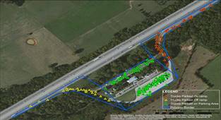
- The major factors affecting the truck parking utilization were found to be truck volume, on ramp and off ramp violations, higher average speeds of the trucks passing the rest area, and presence of a two–lane roadway adjacent to the rest area. Similarly, the early morning hours (immediately after the midnight) were found to be busier than other hours of the day in terms of parking which is very intuitive that the drivers want to take a rest in the night and start the journey again in the am peak hours (6–9 am). The interesting output of the model is that the increment of 100% truck volume increases truck parking utilization by only 1.33% in average. The developed count data models can play an important role in assessing the utilization of the various rest areas and the need for the enhancement. For a screenshot showing the TDOT truck parking analysis see Figure 2.
- Through the identification of shortest paths between each OD pairs connecting the FAF network of Shelby County within Tennessee, TDOT studied the travel time and travel time variation within time of day for recurring and non–recurring congestion. As expected, the travel times are higher in am and pm peaks and lowest during off peak hours. The standard deviation of travel time (travel time variation) for non–recurring congestion followed a similar trend to that of recurring congestion with higher time index.
- To address land use and freight integration, TDOT developed different GIS tools based on truck GPS data with various assumptions acquired from NCHRP Report 37. The model used for the trip distribution is the gravity model. TDOT implemented this methodology in the Jackson MPO region with 48 TAZs. They computed OD trip matrices on TAZ level for different establishments.
Decision Guide: LRP–2, LRP–6, LRP–7.
Assessment(s): Partner collaboration, and stakeholder collaboration.
Application(s): Freight, Performance measures.
Library: Corridor planning studies, freight, performance measures.
Various PlanWorks strategies adopted by different agencies in the past which can be embraced by TDOT for a specific freight corridor like I–40 management. For the corridor management where there has not been any engagement of stakeholders, formation of the committee like Freight Advisory Committee (FAC) consisting of public and private freight stakeholders (e.g., logisticians, motor carriers, industrial real estate developers, railroads, barge, distribution centers, etc.) would be a good start. For example, Delaware Valley Regional Planning Commissions (DVRPC) and Philadelphia Goods Movement Task Force have set a very good example for freight stakeholder engagement advising the partner agency from the freight point of view (source). For those corridors where a committee has already been formed but lacking the effectiveness of the committee or stakeholder engagement, following outreach approaches can be adopted depending upon the type and complexity of the projects.
Memphis MPO consisting of 24 elected officials, Memphis Area Transit Authority (MATA), Memphis–Shelby County Airport Authority (MSCAA), Memphis–Shelby County Port Commission (MSCPC), and representatives from the TDOT and Mississippi Department of Transportation (MDOT) develops and implements the short and long–term plans that meet the community objectives (Memphis MPO, 1977). The Memphis MPO's Public Participation Plan (PPP) from 2014 encourages the entire community and community leaders to participate in developing the feasible alternatives and support the regional transportation network respectively. The PPP guides on how the MPO conducts most of its projects interacting with the public, also thereby increasing the public awareness of transportation services and programs.
Along with Memphis MPO and other stakeholder strategies the report suggested taking an approach formed by local MPO as well as learning from other agencies nationwide.
Next Steps
- TDOT recently released the statewide freight plan, and the outcome of this study will be considered for the next version of the freight plan.
- To address truck parking issues, TDOT is further investigating if it is necessary to build additional rest areas and determining potential locations.
- To improve travel time, TDOT is also researching additional data sources such as WAZE and other data sets to identify recurring and non–recurring congestion.
- TDOT is scheduled to present other findings to various MPOs, RPOs, and TPOs.
Connections to PlanWorks
In the PlanWorks implementation assistance program part of the project TDOT used various parts of decision guide, assessment, and applications. In the decision guide TDOT used: (1) Corridor planning, and long range transportation planning; in Assessment(s): Stakeholder collaboration and key performance measures, and in Application(s): Stakeholder portal and applications in freight.
Decision Guide
The Decision Guide is aimed at aiding in the advancement of the state
of practice in transportation decision–making. TDOT focused on the corridor
planning section of the Decision Guide for this project. The key decision steps
of corridor planning are:
- Approving the scope of corridor plan (COR–1).
- Defining the range of problems and opportunities within the corridor (COR–2).
- Setting the goals (transportation, community, and environmental) for the corridor (COR–3).
- Defining the evaluation criteria, method, and performance measures in order to cross–validate the solutions achieved to the goals set (COR–5).
- Approving the range of solution sets for the corridor (COR–6).
- Selecting the preferred solution set for the corridor plan (COR–7).
Considering the nature of the project TDOT included all decision guide elements except COR–4, 8 and 9.
Assessments
The web–tool is designed with the question sets within each category of assessment which assigns the score of weak, average, or strong. The tool can be used to determine the importance of each category of the assessment to the respective project. TDOT selected stakeholder collaboration for this study because there are large number of stakeholders who are concerned about the process and outcome of this important corridor study who do not have decision–making authority. This collaboration also ensures that the stakeholders who want to be and need to be at the table, are identified and engaged.
The committee will be comprised of regional and local agencies with jurisdiction along the I–40 corridor and private stakeholders (that rely on the corridor for commerce) in West Tennessee. The committee will include continuing dialogue and collaboration with regional and bi–state partners like the Memphis and West Memphis MPOs, Arkansas State Highway and Transportation Department, and Tennessee DOT. In addition, regional chambers of commerce as well as regional carriers (air, trucking, and rail), distribution centers and shipping representatives will be invited to serve as members on the steering committee. The corridor management steering committee will assume the following roles: (a) Provide corridor management oversight in an effort to resolve any issues that may arise during the process (e.g., feasibility of implementation of proposed ideas/strategies), (b) Approve the delineation of the study corridor, (c) Identify and engage regional freight stakeholders into the process, and (d) Review and comment on all draft work products to the extent possible in FAC meetings. In this project TDOT sought to develop a web–based tool to provide the stakeholders access to a web–based portal with information on past, present, and anticipated future traffic flows, freight movement, and traffic congestion of I–40 corridor in Memphis. Additionally the project sought to use performance measures such as travel time, travel time reliability that directly influences freight movement, pickup and deliveries in order to improve the I–40 corridor.
Applications
Performance measures can be used build the consistency, transparency, and accountability into transportation decision–making that helps to improve the planning. These measures can be used to evaluate the major highway capacity projects and can be used after project completion to monitor the effectiveness of the implemented solutions. Four major performance measures can be used to assess the transportation system performance– mobility, reliability, accessibility, and safety. Of these, TDOT focused on mobility and reliability.
Library
The project used a number of case studies related to corridor planning and long range transportation planning. The three case studies TDOT reviewed are: (1) Route 31 Integrated Land Use and Transportation Plan – Capacity Expansion Consistent with Smart Growth in New Jersey, (2) I–710 Corridor Study – Community–driven Plan for Important Freight Corridor in California, and (3) Kelly Parkway Planning and NEPA Studies – Balancing Environmental Justice and Economic Development in Texas.
For More Information
Contacts
Name of Primary Agency ContactDr. Casey Langford
Long Range Planning Division
Tennessee Department of Transportation
(615)532–5824
casey.langford@tn.gov Name of Primary FHWA Contact
Reena Mathews
Federal Highway Administration
(202)366–2076
reena.mathews@dot.gov