US Department of Transportation
FHWA PlanWorks: Better Planning, Better Projects
Efficient Transportation Decision Making (ETDM) Process (Florida)
Overview
Project Overview
Florida’s Efficient Transportation Decision Making (ETDM) Process, is the process Florida uses to accomplish early agency participation in project decision making, efficient environmental review, and meaningful dispute resolution. The ETDM Process is used for major transportation capacity improvement projects, encompassing planning, environmental reviews, project development, and permitting phases.
Background
- Advisory Council on Historic Preservation
- Federal Highway Administration
- Federal Transit Administration
- Florida Department of Agriculture and Consumer Services
- Florida Department of Community Affairs
- Florida Department of Environmental Protection
- Florida Department of State
- Florida Department of Transportation
- Florida Fish and Wildlife Conservation Commission
- Florida Metropolitan Planning Organization Advisory Council
- The Miccosukee Tribe of Indians of Florida
- National Marine Fisheries Service
- National Park Service
- Natural Resources Conservation Service
- Northwest Florida Water Management District
- The Seminole Tribe of Florida
- South Florida Water Management District
- Southwest Florida Water Management District
- St. Johns River Water Management District
- Suwannee River Water Management District
- U.S. Army Corps of Engineers
- U.S. Coast Guard
- U.S. Environmental Protection Agency
- U.S. Fish and Wildlife Service
- U.S. Forest Service
Florida’s ETDM Process was developed in response to the Congress’ “Environmental Streamlining” initiative. As part of the Transportation Equity Act for the 21st Century (TEA-21), Environmental Streamlining called for improved and more efficient transportation planning and environmental review processes. In response to this initiative, Florida developed a new way of accomplishing transportation planning and project development called Efficient Transportation Decision Making or the ETDM Process. The new ETDM Process adopted the objectives outlined by the Congress in TEA-21:
- Effective/timely decision making without compromising environmental quality,
- Integrating review and permitting processes,
- Early National Environmental Policy Act (NEPA) reviews/approvals,
- Full and early participation, and
- Meaningful dispute resolution mechanisms.
The Florida Department of Transportation (FDOT) decided to reexamine the Department’s entire process from the very early stages of planning through project development and permitting. Working in collaboration with the Federal Highway Administration (FHWA), FDOT invited federal and state agency heads together in a “summit” in February 2000 to request their agency support in reexamining the entire transportation planning process. Each agency designated one point of contact to participate in a multi-agency working group to redefine how projects would be planned, reviewed and subsequently permitted. Initially, 23 federal, state and regional agencies helped to develop this process and supporting technology system. Ultimately, participation also included two federally recognized Native American Tribes. Participants requested the following key features in a new process:
- Early and continuous agency involvement,
- Good data upon which to base decisions, and
- Feedback about how agency participation resulted in better transportation decisions.
Through this working group, the State of Florida completely revamped its procedures for planning transportation projects, conducting environmental reviews, and developing and permitting projects. The fundamental goal of the ETDM Process is to improve transportation decision-making in a way that protects the human and the natural environment.
ETDM Process Overview
The ETDM Process comprises three phases: Planning, Programming and Project Development (see Figure 1). The ETDM Process brings agency and community interaction forward into the early stages of transportation planning. Efficient interaction with agencies and the affected community is gained by two screening events that are completed and integrated into the transportation planning process. The screening events, known as the Planning Screen and the Programming Screen, engage agencies and the affected community earlier than they were in the traditional planning process. Information and recommendations from the agencies and the public as a result of these screening events are summarized and could provide the basis for technical studies and preliminary engineering designs performed during Project Development.
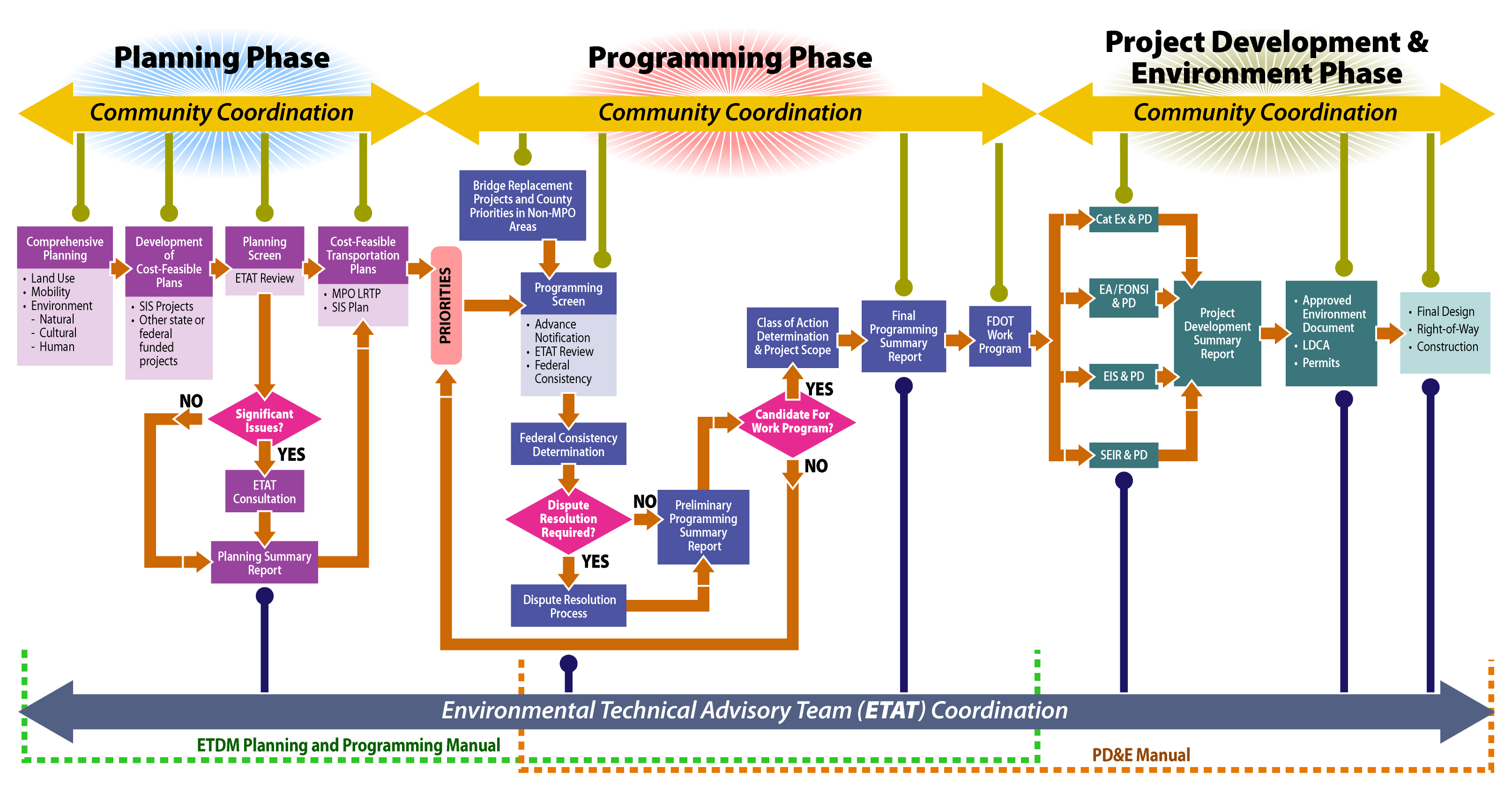
Figure 1: ETDM Process Overview
The Planning Screen occurs in conjunction with the development of long range transportation plans. This initial screening of planned projects allows participants to review project Purpose and Need Statements and comment on the potential impact of projects to environmental and community resources very early in the planning process. Direct and indirect effects of proposed projects are evaluated and documented in the Environmental Screening Tool (EST). This opportunity enables planners to adjust project concepts to avoid or minimize adverse effects, consider mitigation alternatives, and improve project cost estimates. Cumulative effects to resources are evaluated on a system-wide basis in connection with the Planning Screen. The interrelationships between land use, ecosystem management, community values, and mobility plans are considered through integrated agency planning. Key recommendations and conclusions regarding potential project effects are provided in the Planning Summary Report. This report provides information that helps planners to stage transportation priorities in long-range transportation plans and is available electronically to resource agencies and the public.
The Programming Screen occurs before projects are funded in the FDOT Five-Year Work Program. Input about the potential effects to environmental and community resources is the basis for “agency scoping” to facilitate compliance with federal and state environmental laws. If potential dispute issues are identified, FDOT may initiate the Dispute Resolution Process before the project is programmed into the FDOT Five-Year Work Program. Potential disputes may also be identified through the public involvement process and require resolution prior to the project being advanced into the design or construction phase of the Work Program. Lead agencies decide on a Class of Action Determination for each priority project which is summarized along with potential project effects, preliminary project concepts, reasonable project alternatives, and scoping recommendations.
Agency interaction occurs throughout the life of a project to ensure that transportation decisions are balanced with effects on natural, cultural and community resources, land use decisions, and other agency goals or objectives. This is accomplished through an Environmental Technical Advisory Team (ETAT). An ETAT, consisting of planning, regulatory and resource agencies, has been established for each of the seven geographic FDOT Districts. Each agency appoints a representative or representatives that are responsible for coordinating and performing all actions to satisfy their responsibility with respect to the planning and development of transportation projects. The ETAT representatives have authority and responsibility to coordinate internally and represent their agency’s positions. The role of the ETAT representatives changes from advisory during the Planning and Programming Phases to coordination during the Project Development Phase and environmental permitting.
Community outreach also occurs throughout the life of a project. The public involvement strategy uses various techniques such as mailings, Internet postings, and formal public workshops. At the beginning of both the Planning Screen and Programming Screen, the Community Liaison Coordinators (CLCs) notify the public that the projects are in the review period. At this time, the public may review project data, results of Geographic Information System (GIS) analyses, and corresponding resource mapping, using the EST or through the MPO or FDOT District office. During the review period, the public provides input to MPOs, FDOT, and the resource agencies through normal public involvement channels (workshops, correspondence, telephone communication, etc.). Summary reports and ETAT comments are made available to the public as soon as the ETDM Coordinator posts the finalized summary report. Following the screening events, the project information, GIS results, mapping, ETAT reviews, and summary reports continue to be available to the public through the Web site. At the beginning of subsequent ETDM phases, any updates to project information are posted to the public access site. A record of the project history is maintained and made available as well. Throughout project development, project managers upload technical studies and environmental documents into the EST. They can also provide links to any project-specific Web sites. Information is also available in hard-copy format at workshops, hearings, and upon request.
Environmental reviews and communication among the participants and the public is assisted through the EST. The EST is an Internet-accessible interactive database and mapping application. The EST integrates resource and project data from multiple sources into one standard format and provides quick and standardized analyses of the effects of the proposed project on natural and human resources. It provides a mechanism to input and update information about transportation projects and community characteristics, perform standardized analyses, report comments by the ETAT representatives, and provide read-only information to the public. Its database maintains the project record throughout the life-cycle of the project.
Results of the ETDM Process
The EDTM Process has improved the planning of transportation projects, conducting environmental reviews, and developing projects for NEPA compliance and permitting in the following ways:
- Improved agency coordination and problem-solving,
- Improved long range transportation planning,
- Focused evaluations during project development,
- Improved dispute resolution process,
- Less costly environmental studies and documentation,
- Shortened project delivery,
- Better access to information, and
- Enhanced coordination within FDOT.
Screening Process Overview
The ETDM Process includes two screening events: the Planning Screen, conducted in the Planning Phase; and the Programming Screen, conducted in the Programming Phase. These screening events provide valuable information to assist in elimination, selection, and modification of alternatives. The difference between the two screens lies in the context and content of the reviews. The Planning Screen is looking at the project alternatives at a high level planning perspective to determine whether or not the alternatives are feasible for inclusion in the long range transportation plan, usually a 30 year outlook. During the Programming Screen, participants provide advice to help scope the project development studies. Alternatives may be eliminated or modified in either phase, but the review is often more detailed in the Programming Phase. The general screening process for both of these screening events is the same and is described below.
The Problem
The transportation planning process begins when MPOs and FDOT are identifying mobility needs. Project needs are matched to available funding for projects, and ultimately a cost-feasible plan is adopted by the MPOs. This is referred to as the Long Range Transportation Plan (LRTP). Similarly, FDOT develops a cost-feasible plan for the Florida Intrastate Highway System (FIHS) and for the Bridge Program. Priority projects are selected annually from these cost-feasible plans and are presented to the Legislature as the tentative Work Program. The Legislature then approves the Work Program. The Work Program is a five-year program. New projects may await funding for up to five years before significant work proceeds. The Project Development and Environment (PD&E) process begins after funding for a project is approved, and then design survey work is conducted, and the design phase begins. The PD&E phase is a more detailed analysis of a proposed project’s social, economic and environmental impacts, as well as various project alternatives.
Before ETDM, agency interaction did not begin until the PD&E process (also referred to as “Project Development”) was well under way. Many of Florida’s resource agencies traditionally would wait for the submittal of a permit application before they expended significant effort to review the project. This would typically occur at about the 60 percent level of detail in the design phase. The problems with this process included:
- Long time gaps occurred between some steps;
- By the time PD&E began, information gathered earlier could be obsolete;
- Community concerns elicited during planning might not have been effectively communicated to designers;
- Resource agency review occurred late in the process after substantial and expensive work had been performed;
- Environmental considerations were not fully factored into the project cost; and
- Too much momentum had built for delivery of the project to allow significant change.
The Rose Bay Bridge project in Port Orange, Florida exemplifies the problems that could occur with late resource agency involvement. In its final configuration, a new bridge spans the entire waterway. Originally, this roadway crossed the waterway on a causeway with a short bridge near the center of the waterway. That short bridge was deemed operationally obsolete and was scheduled for replacement. The replacement bridge was designed, and permit applications were submitted. The final permit for the replacement bridge was denied based on water quality considerations, and ultimately a completely new bridge was designed (which opened the waterway to historical flow patterns).
Late agency involvement in this case led to late agency permit denial, and FDOT had to completely redesign the bridge and reapply for permits. This is exactly the type of problem that is not expected to occur when projects are developed using Florida’s ETDM Process. Early agency involvement, identification of issues, and resolution of issues, avoid lost time and money and duplication of effort.
Screening Process Steps
The ETDM Process affords resource agencies and the public the opportunity to provide early input to the FDOT and Metropolitan Planning Organization (MPO) Boards on a project’s potential impacts to the natural, cultural and built environments through a series of “screening” events: the Planning and Programming Screens. The Environmental Screening Tool is used to support a four step process during both of these screening events as illustrated in Figure 2:
- Data Entry,
- GIS Analysis,
- Project Review, and
- Summary Report Publication.
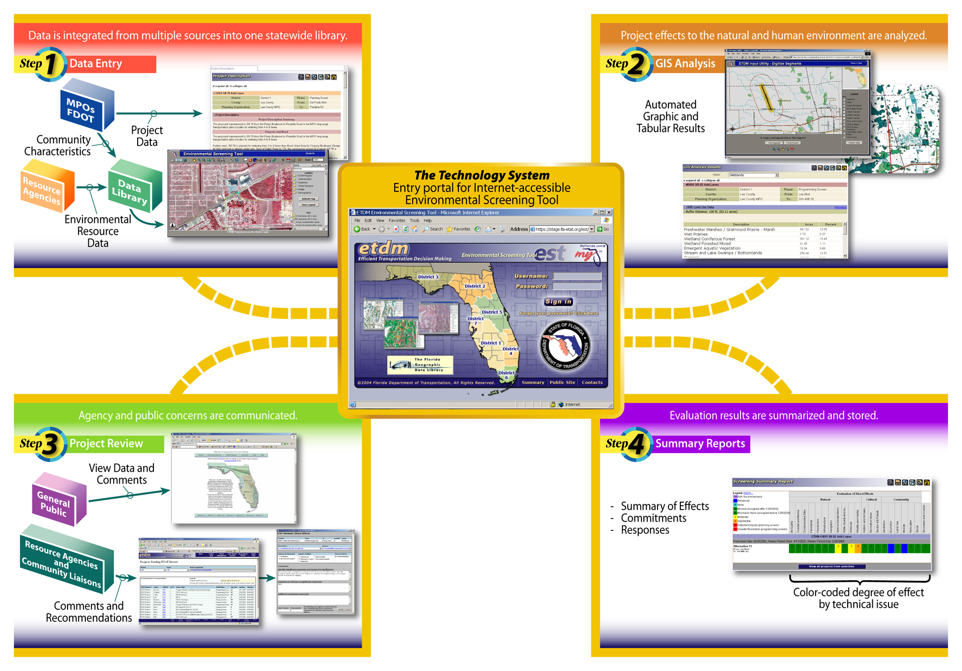
Figure 2: Four Steps of the ETDM Screening Events
Step 1. Data Entry: MPO and FDOT planners use the EST application to record information about proposed transportation projects. These organizations may also provide community characteristic information for their areas of jurisdiction. Resource agencies provide information describing their priority resources to the Florida Geographic Data Library (FGDL), which is repository of GIS data gathered from multiple sources. This information is loaded into the ETDM database and is accessed through Internet map services. One of the responsibilities of agency ETAT representatives is to ensure that their agency data are current in the FGDL. During early multi-agency meetings “good data” was identified as a key to achieving successful early agency involvement. Project planners are responsible for data entry regarding project plans. ETAT members are responsible for seeing that the best available data from their agencies are in the FGDL. FGDL personnel routinely gather data from other sources such as local governments. ETAT members are also responsible for understanding data limitations. Some data gaps may occur. Some data may be inaccurate, out of date or incomplete. ETAT members are responsible for understanding their data, performing reconnaissance to verify data, and recommending a technical study to accumulate appropriate data for the FGDL, if warranted.
Step 2. GIS Analysis: After projects are loaded in the database, standard GIS analyses are automatically performed to identify potential environmental effects. These analyses were initially prescribed by the resource agencies during the needs assessment and include concerns such as, identifying National Register Sites within a mile of proposed projects, describing wetland characteristics within the potential right of way, or locating critical species habitat within a half mile of the project. The results are stored in the database along with the project information. Approximately 300 analyses are automatically performed and stored for each project alternative. EST users typically view and query a subset of the analyses which describe the resources in which they are specifically interested.
Step 3. Project Review: When a project is ready to be reviewed, the ETDM coordinators in the FDOT District Offices notify their Environmental Technical Advisory Teams (ETATs) that the latest project information is available on the ETDM Web site and ready for review for potential project effects. This notification begins the 45-day ETAT review period. At this time, the District or MPO Community Liaison Coordinators (CLCs) notify the public that the project is in the review period. Agency representatives and the public review project details, resource maps of the project location, and the results of the GIS analyses. They supplement their review with additional information and local knowledge of the area. Agency representatives coordinate internally to resolve agency positions. When the internal position is formulated, they enter the agency comments into the database. The ETAT members provide a “Degree of Effect” and recommendations for avoidance and minimization of adverse effects. The Degree of Effect indicates the level of potential impact (positive or negative) that the proposed project alternative may have on the natural, human or cultural environments (See Table 1). The ETAT members review each alternative separately to indicate if some are preferred over others. They may also recommend new alternatives to be considered. The public provides comments to MPOs, FDOT, and the resource agencies through normal public involvement channels (e.g. workshops, correspondence, telephone communication, emails, etc.).
Degree of Effect |
ETAT |
Community |
|---|---|---|
|
Not Applicable / No Involvement |
There is no presence of the issue in relationship to the project, or the issue is irrelevant in relationship to the proposed transportation action. |
|
|
Enhanced |
Project has positive effect on the ETAT resource or can reverse a previous adverse effect leading to environmental improvement. |
The affected community supports the proposed project. Project has positive effect. |
|
None |
The issue is present, but the project will have no impact on the issue. Project has no adverse effect on ETAT resources. Permit issuance or consultation involves routine interaction with the agency. |
No community opposition to the planned project. No adverse effect on the community. |
|
Minimal |
Project has little adverse effect on ETAT resources. Permit issuance or consultation involves routine interaction with the agency. Low cost options are available to address concerns. |
There is minimal community opposition to the planned project and/or minimal adverse effects on the community. |
|
Moderate |
Agency resources are affected by the proposed project, but avoidance and minimization options are available and can be addressed during project development with a moderated amount of agency involvement and moderate cost impact. |
Project has adverse effect on elements of the affected community. Public Involvement is needed to seek alternatives more acceptable to the community. Moderate community interaction will be required during project development. |
|
Substantial |
The project has substantial adverse effects but ETAT understands the project need and will be able to seek avoidance and minimization or mitigation options during project development. Substantial interaction will be required during project development and permitting. |
Substantial interaction will be required during project development and permitting. Project has substantial adverse effects on the community and faces substantial community opposition. Intensive community interaction with focused Public Involvement will be required during project development to address community concerns. |
|
Potential Dispute (Planning Screen) |
Project may not conform to agency statutory requirements and may not be permitted. Project modification or evaluation of alternatives is required before advancing to the LRTP Programming Screen. |
Community strongly opposes the project. Project is not in conformity with local comprehensive plan and has severe negative impact on the affected community. |
|
Dispute Resolution (Programming Screen) |
Project does not conform to agency statutory requirements and will not be permitted. Dispute resolution is required before the project proceeds to design. |
Community strongly opposes the project. Project is not in conformity with local comprehensive plan and has severe negative impact on the affected community. |
Step 4. Summary Report Publication: After the review period, ETDM Coordinators in the MPOs and FDOT compile the results of the ETAT review in a summary report containing key recommendations and conclusions for the effects identified by the ETAT and through community outreach activities. While compiling the results, the ETDM Coordinator consults with ETAT members to work out differences in assigned degrees of effect, and to resolve any disputed issues. At this point, in both the Planning and Programming Phases, alternatives may be eliminated or modified. These decisions are based on the data provided by the standard GIS analyses and the comments received from the ETAT and public. The recommendations and findings in the summary report become the basis for project modifications and advancement. The summary report also provides feedback to agencies and the public.
Dispute Resolution
A key feature of the ETDM Process is its Dispute Resolution procedure. Agencies may not always agree with each other about how to resolve adverse effects associated with a transportation project. FDOT may not agree with agencies about certain issues. One thing is agreed upon by all agencies in the ETDM Process, however: disputes must be resolved before projects advance into final design.
FDOT worked with the multi-agency working group to develop a dispute resolution process that accommodates the above commitment. The ETAT in each of the seven geographic Districts, under the leadership of the MPO and District ETDM Coordinators, first work to resolve disputes. The ETDM Coordinator may use informal mediation within the District’s ETAT to achieve resolution. If the ETAT is unable to resolve the issue, then a white paper is prepared presenting positions and recommended solutions. That white paper is provided to local agency heads for their consideration. They may resolve the dispute locally or elevate it further to statewide agency heads, then to the Governor and to federal processes, if necessary. However, it is not anticipated that disputes would actually be continued beyond agency head level. The process is diagrammed in Figure 3.
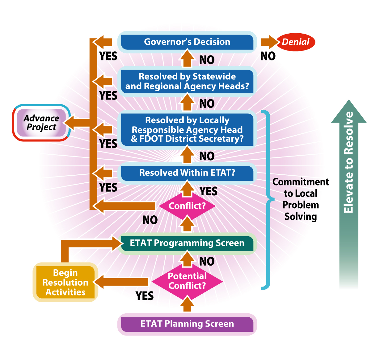
Figure 3: ETDM Dispute Resolution Process
The intent of the entire ETDM Process is that through early agency input and continuing involvement, an acceptable project will be developed – a project that addresses the mobility need while simultaneously protecting the extremely valuable community and environmental resources which make Florida unique. If consensus cannot ultimately be reached on that acceptability, then the project will not move into final design.
A recent example of the ETDM dispute resolution process at work is the US 41 project that was planned to partially traverse the Collier-Seminole State Park in Collier County. The ETDM Dispute Resolution Process was used to successfully resolve project conflicts. Through an ETDM Process review of the proposed project, the US Fish and Wildlife Service (USFWS) alerted the FDOT of potential impacts to Florida panther habitat, as well as other park features. Based on these potential impacts, the USFWS disputed the need for four lanes through the park. The dispute resolution process involved the USFWS, the Collier County MPO, and FDOT District One. Early collaboration allowed these interests to identify an alternative project concept which avoided or resulted in less environmental or sociocultural impacts than the original project proposal. The resulting project concept included a two-lane roadway through the park and operational improvements that achieved mobility goals while also responding to environmental preservation goals. The conflict was resolved in advance of the Project Development phase, and the collaboration facilitated by the ETDM Process succeeded in developing a balanced project alternative that was satisfactory to all participating interests. Ultimately, this new project concept enabled the FDOT to recommend a lesser class of action than the original concept would have required (Type 2 Categorical Exclusion rather than Environmental Impact Study). The Dispute Resolution process enabled a win-win situation for all parties involved.
Outcomes
The results of the ETDM screening events guide planners in staging transportation priorities and clarify the scope of future work as the project moves forward into subsequent phases. Since its implementation in 2004 through June 2007, approximately 300 individual projects have been screened using the ETDM process. In an effort to assess what benefits have resulted from using this process over the last three years, the Districts were recently surveyed. Each District reviewed the projects within their District which have gone through the screening process and were asked to assess what benefits if any, had accrued as a result. The results of the District surveys were reported in the 2007 ETDM Status Report, and an estimated cost savings of $15.2 million and cumulative time savings of 38 years have been realized since implementation of the ETDM process in 2004. The primary reason behind the savings, as reported by the Districts, is due to early ETAT coordination and involvement.
Both tangible and intangible benefits have been realized from the ETDM process. Some of these benefits include:
- Earlier recognition of the potential impacts a project under consideration might have on the natural, cultural and human environment and what the associated costs might be;
- More focused scopes of work for Project Development and Environment (PD&E) Studies;
- Expedited reviews by multiple agencies;
- Earlier agreement on elimination of unreasonable alternatives;
- Downgraded Class of Action Determination based on agency comments received;
- Shortened project delivery times;
- Less costly environmental studies and documentation;
- Better access to public information and agency review comments;
- Enhanced coordination between FDOT and resource agencies; and
- Reduction of problematic projects or alternatives in the planning phase.
Below are some examples of how focused evaluations during project development have resulted in cost savings and shortened project delivery.
- ETAT review of the SR 70 from Turnpike to Jenkins Road project in St. Lucie County (District 4) and coordination with the ETAT members allowed elimination of the Wetlands Evaluation Report and a reduced Endangered Species study, saving time and money in the PD&E Study. The ETDM Process allowed the SR 70 PD&E Study to be completed eight months ahead of schedule and with an estimated savings of $500,000 compared to the traditional PD&E process.
- Districts 4 and 6 in south Florida utilized ETDM to expedite the review and production of the I-95 Managed Lanes Pilot Project: 95 Express. The EST allowed the Districts to distribute information quickly, provide continuous coordination, and to receive agency review comments in a timely manner. Additionally, ETDM allowed the agencies to narrow the range of required technical studies, reduce the scope of the technical studies and achieve an early and clear Class of Action determination.
- District 5 was able to minimize the scope of work required for a Cultural Resource Assessment Survey on the Sandlake Road project in Orlando, Florida based on the detailed State Historic Preservation Office (SHPO) review and comment.
- District 5 accelerated the production schedule for the US 17/92 project by overlapping the PD&E and Design schedules and moving survey work into the PD&E phase. Additionally, the District is working towards shortening the timeframe between design and permitting. The District was able to accomplish this by using the ETDM Process to reduce the overall production timeframes through early agency involvement and consistent, well-documented information.
- Focused, early technical studies on key project issues facilitated an aggressive production schedule for an I-95 Interchange project in District 5. The SHPO ETAT member noted that a Cultural Resource Assessment Survey did not need to be done for the I-95 Interchange, as records showed that one had been done previously.
- In the aftermath of Hurricane Ivan, when the I-10 bridges crossing Escambia Bay in Pensacola needed to be replaced, the EST helped the District 3 ETDM Coordinator to distribute information about the project quickly and easily, and provided an avenue for agency responses. Additionally, FDOT was able to coordinate an early agency meeting and review by using the District ETAT representatives. The District ETAT was given a notice that the project was a high-priority, emergency project. The traditional 45-day review period was reduced to a 15-day review period in order to expedite the process. The PD&E process, which is traditionally an 18-month to 24-month endeavor, was completed within 15 weeks.
- ETDM screening of the Blue Heron Tidal Relief Bridge replacement showed that no U.S. Coast Guard (USCG) permit was required, and the environmental Class of Action was reduced to a Non-Major State Action (NMSA) instead of a Categorical Exclusion (CE). (When a District evaluates a project as a NMSA, the project does not require a public hearing but may require public involvement.)
- On a District 5 Public Private Partnership project, the developer’s consultant indicated that ETAT comments saved both time and money by identifying the need to raise the Tomoka River Bridge, early in project development. Early identification of this issue saved potentially 1000 or more staff hours related to the cost of finding this out later during the permitting.
Key Aspects of the Screening Process
Scope
The ETDM Process is Florida’s procedure for planning, conducting environmental reviews, developing, and permitting of major transportation projects. The Florida Department of Transportation (FDOT) follows the ETDM Process for major capacity improvement highway and transit projects in the FDOT Work Program. “Major capacity” as defined in the ETDM Process includes these types of projects:
- Capacity is being added to an existing road in the form of additional through lanes;
- New roadways;
- New interchanges or major interchange modifications;
- New bridges, bridge replacements, or bridge projects involving additional lanes; and
- Major transit projects.
Any major capacity project in MPO long-range transportation plans is included. In addition, any project being added to the FDOT Work Program that requires a Type 2 CE, Environmental Assessment (EA), or Environmental Impact Study (EIS) goes through the ETDM Process if it meets any of the following criteria:
- It will be funded with Federal funds;
- It is on the Strategic Intermodal System (SIS) and will be State funded with FDOT as the Lead Agency;
- It is on the State Highway System (SHS) (regardless of funding);
- It is a regionally significant project off the SHS, receiving State funds, and FDOT is expected to be the Lead Agency; or
- It is a major public transit project (such as Intermodal Passenger Center, rail passenger service, transit center) where FDOT is expected to be the Lead Agency.
The ETDM screening events occur in multiple phases in the project life cycle. These screening events help to integrate the ETDM Process with other planning activities. The Planning Screening occurs at the Long Range Transportation Plan development stage and the Programming Screen occurs just prior to a project entering the FDOT Five Year Work Program. During these screening events, the Department of Community Affairs reviews the project for consistency with the Local Government Comprehensive Plan to help ensure integration with local land use planning activities. Summary reports are available for local governments to use when updating their plans.
The ETDM Process screens project alternatives during the planning concept phase, prior to significant design. These alternatives may represent general study areas or specific corridors that are being considered for the project. They do not typically represent “left, right or center” alignment alternatives. However, the ETAT may provide specific guidance which would help designers to avoid or minimize impacts to the resources. For example, in reviewing a proposal to widen an existing roadway, the ETAT may note that fewer wetlands impacts would occur on one side of the roadway than on the other.
Communications
Agency Involvement
Each of Florida’s seven geographic FDOT Districts has an Environmental Technical Advisory Team (ETAT) comprised of the following:
- FDOT ETDM Coordinator – responsible for overall coordination within the Department and with the MPOs, resource agencies and the community.
- MPO ETDM Coordinator – responsible for agency and community interaction in MPO areas through the Programming Screen Phase (except for bridges and FIHS).
- Community Liaison Coordinator – responsible for assessing potential impacts on communities, interacting with the affected community, and providing information to and receiving input from the public about project plans.
- ETAT Reviewers – consists of representatives from agencies which have statutory responsibility for issuing permits or conducting consultation under NEPA, and representatives of participating Native American tribes. ETAT members evaluate project effects on resources within their jurisdiction, and communicate using the Environmental Screening Tool, supported by meetings, calls and e-mails.
ETDM Agreements between Federal Highway Administration (FHWA), FDOT and the resource agencies outline the roles and responsibilities of those participating in the ETDM Process and document funding levels. Currently, there are three separate agreements employed within the ETDM Program: the Master Agreement, the Agency Operating Agreement and the Funding Agreement. All three agreements contribute to the successful maintenance and operation of the ETDM Process. Each participating agency negotiates the terms and conditions of its agreement based on the agency’s regulatory and statutory requirements and funding resource needs. Currently, the FDOT has agreements with the following 18 agencies:
- FHWA with Federal Transit Administration (FTA)
- Florida Department of State (SHPO) and Advisory Council of Historic Places
- Florida Department of Environmental Protection (FDEP)
- Florida Department of Community Affairs (FDCA)
- Florida Department of Agriculture & Consumer Services (FDACS)
- Florida Fish & Wildlife Conservation Commission (FFWCC)
- National Marine Fisheries Service (NMFS)
- National Park Service (NPS)
- Natural Resources Conservation Service (NRCS)
- Northwest Florida Water Management District (NWFWMD)
- Southwest Florida Water Management District (SWFWMD)
- South Florida Water Management District (SFWMD)
- St.Johns River Water Management District (SJRWMD)
- Suwannee River Water Management District (SRWMD)
- US Army Corps of Engineers (USCOE)
- US Fish and Wildlife Service (USFWS)
- US Environmental Protection Agency (USEPA)
- US Forest Services (USFS)
The following participate in the ETDM Process without a formal signed agreement:
- USCG
- The Miccosukee Tribe of Indians of Florida
- The Seminole Tribe of Florida
All of the interaction with agency ETAT members and with the public during the Planning Screen provides guidance and recommendations during early phases of project planning. The ETAT identifies avoidance and minimization issues, and the CLC works with the community to address community issues and community requests regarding desired project features. The ETAT performs the following tasks for each candidate mobility project:
- Develop an understanding of the proposed transportation action by reviewing the project description, Purpose and Need Statement, and public comments from previous outreach activities.
- Review and comment on the Purpose and Need Statement. (The ETAT representative of the lead federal agency should accept the Purpose and Need Statement.)
- Perform a project-level review of the potential direct and indirect effects to resources that the ETAT member agency is responsible for protecting and/or managing. This includes providing commentary about the potential effects of the proposed action to natural, cultural and community resources and the basis for this determination.
- Indicate the degree of effect (enhanced, minimal, none, moderate, substantial, potential dispute, or not applicable) to the natural, cultural, and community resources based on a direct and indirect effects evaluation. Guidance for assigning the degree of effect is provided in Table 1.
- Provide commentary and indicate the degree of effect regarding possible cumulative effects to resources that the ETAT member agency is responsible for protecting and/or managing.
- Provide recommendations of proposed actions or project design features that could lessen project effects on at-risk resources. This could include avoidance, minimization, or mitigation measures.
- Provide information about agency plans or other key data that affect the project area.
- Decide whether future involvement is needed or elect “no further involvement.”
- Identify information gaps or data needed to support further evaluation.
During the screening events, the CLCs and MPOs conduct sociocultural effect (SCE) evaluations on major transportation improvement projects to determine potential impacts to the community. In addition, the following activities can be performed by the CLCs and MPOs to prepare for the SCE evaluation in each screening event:
- Establish a network of community contacts
- Conduct community outreach activities
- Organize and summarize community concerns
- Review availability and accuracy of data
- Collect additional supporting data
- Develop Community Characteristics Inventories
- Consider issues inherent in SCE considerations to structure public outreach activities
During the Programming Screen more specific information is developed, which affects the scope of work to be performed during Project Development. The following is a list of typical ETAT review activities completed during the Programming Screen:
- Review and indicate consistency with agency’s statutory authority in the Florida Coastal Management Program (state agencies and Water Management Districts).
- Perform a project-level review of the potential direct and indirect effects to resources that the ETAT member agency is responsible for protecting and/or managing. This includes providing commentary about the significance of the proposed action to natural, cultural and community resources and the basis for this determination.
- Review and comment on the Purpose and Need Statement. (For those projects reviewed during the Planning Screen, the ETAT representative for the lead federal agency should accept the Purpose and Need Statement.)
- Indicate the degree of effect (enhanced, minimal or none, moderate, substantial, dispute) to the natural, cultural, and community resources for direct effects. Guidance for assigning the degree of effect is provided in Table 1.
- The lead federal agency and FDOT determine the Class of Action, with the assistance of other state and federal agencies, as applicable.
- Review project consistency with Local Government Comprehensive Plans and statewide goals and objectives.
- Review and comment on project concepts and alternatives being considered, such as possible typical sections, preliminary footprint, and alternative corridors.
- Identify permit ability issues and general mitigation measures needed based on agency statutory responsibilities.
- Perform project scoping activities based on review of GIS databases and project information and identify required technical studies or analyses that need to be completed during the Project Development Phase.
- Reach conclusions on non-major environmental issues based on early resolution and/or agreement.
- Review and comment on summary of community issues and public concerns.
- Participate in dispute resolution, if necessary, to assist the ETDM Coordinator to identify solutions to project concerns. Participate on ETAT subteam to review and resolve conflicts informally at the local level.
- Decide whether future involvement is needed or select “no further involvement.”
- Review the Final Programming Summary Report when it is made available through the ETDM Web site and provide feedback to FDOT.
The CLC is responsible for the following review activities during the Programming Phase:
- Review Community Characteristics Inventory to determine if updates are needed.
- Review potential sociocultural effects identified in the Planning Phase.
- Update sociocultural effects evaluation if needed.
- Indicate the degree of effect to community resources.
- Summarize public comments and issues in Preliminary Programming Summary Report.
During the PD&E Phase, coordination by ETAT members occurs to ensure that others within the agency understand the project concept and the basis of design. The intent is that there are “no late surprises” (late requests for another scope of work, permit condition changes, permit denials, community concerns or disapproval).
At the end of the Planning, Programming, and PD&E Phases, the ETDM Coordinator publishes a summary report which compiles the commentary, findings, and recommendations of the project to date. This report comprises the project record and is used in subsequent phases to direct future work on the project. Input received by the agencies influences the project design and priorities as it moves forward. This includes selection of projects and/or alternatives for the LRTP, projects that are programmed, and the selection of preferred alternatives in project development.
Public Involvement
A primary objective of the ETDM Process is the identification of community issues through public outreach in the early phases of a project – the Planning and Programming phases. In this manner, the public is provided the opportunity to consider the project in its most conceptual form and provide feedback on project issues before significant effort is expended on project development. Public input can then be used to shape the project to be compatible with local conditions or, in the event of major issues, to develop project alternatives.
Public outreach for ETDM projects should include meaningful activities that are consistent with the level of available project information, project review timeframes and budgets. The type and extent of public outreach activities for ETDM projects will differ based on characteristics of the project and project area and the degree of existing public commentary on the project. Ideally, initial public outreach for ETDM projects occurs in advance of the project screening period so that public commentary is available to support the ETAT review – particularly the SCE evaluation. An opportune time to plan the public outreach strategy is during the pre-screening period, which is generally the 90 day period preceding the start of the project screening event.
Given the amount of time that typically transpires between the identification of a project and its construction (often 15 years or more); it is improbable that sufficient interest exists within the community to draw an audience for a sole purpose meeting addressing a Planning or Programming phase project. For these long range projects, public outreach that is held in conjunction with community organization meetings is more likely to have a sufficient audience to receive and respond to project information. In other words, for ETDM project outreach, “it’s better to crash a party than to throw one”. The following examples of methodologies for involving the public have been used for early public outreach with ETDM projects:
- General Public. Investigate the demographic characteristics of the project area in order to identify one or more neighborhood associations, fraternal organizations, or other organized community groups for an outreach event. For larger projects, diverse project contexts or controversial projects, multiple community groups may need to be targeted for input. Outreach to one or two groups should be sufficient for projects at the opposite end of the complexity spectrum. Seek assistance from MPO committees, elected officials or county social services agencies in identifying community groups or special population groups in the project area. Also, much can be learned about the community by simply visiting the project area and talking to people. After choosing which community organization(s) is most representative of the project area population, contact the association’s executive officer and arrange to have the ETDM project placed on the organization’s meeting agenda.
- Special Interest Groups. Special interest groups, such as merchant or builders associations, may want to participate in the project outreach effort if the potential exists for effects on resources or conditions that are of concern to the group’s membership. Contact the association’s executive officer to request a portion of the group’s regularly scheduled meeting to present the ETDM project, solicit comments, and verify project information.
- Governmental Organizations. Routine involvement in transportation and other community development matters afford MPO and local government transportation committees a high level of familiarity with the various communities and conditions in the county or planning area. In MPO counties, transportation decision making is supported by a set of advisory committees, which may include the following:
- Citizens Advisory Committee
- Technical Advisory Committee
- Bicycle Advisory Committee
- Pedestrian Advisory Committee
- Rural counties may have committees that perform similar functions. These committees typically have monthly meetings to discuss and make recommendations on transportation actions to the MPO Board or Board of County Commissioners. Arrange to have the ETDM project placed on committee meeting agenda to solicit the membership’s assistance in verifying project information, identifying potential community issues, targeting community groups for public outreach and suggesting topics and content of public opinion surveys to be administered in conjunction with public outreach activities.
- Nongovernmental Organizations. Nongovernmental organizations that concern themselves with environmental, community development, environmental justice, or fiscal issues should be afforded the opportunity to comment on ETDM projects. These organizations are usually listed on a community contacts list maintained by the MPO or local government, whereby they are kept apprised of MPO or county transportation actions.
When a project is ready to be reviewed during the Planning or Programming Screen, the ETDM coordinators in the FDOT District Offices notify their ETATs that the latest project information is available on the ETDM Web site and ready for review for potential project effects. This notification begins the 45-day ETAT review period. At this time, the District CLC or MPO personnel notify the public that the project is in the review period. The public may review project data, the results of GIS analyses and corresponding resource maps, using the ETDM Web site or through the MPO or district office. The public provides comment to MPOs, FDOT, and the resource agencies through normal public involvement channels (e.g. workshops, correspondence, telephone communication, emails, etc.). At the end of the review period, the ETDM coordinators summarize and respond to comments in a screening summary report which is published on the Web site. All of the project information, GIS results, mapping, ETAT reviews, and summary reports will continue to be available to the public through the web site. At the beginning of subsequent ETDM phases, any updates to project information are posted to the public access site. A history record of the project is maintained and made available as well. Throughout Project Development, project managers upload technical studies and environmental documents into the EST. They can also provide links to any project-specific web sites. Links to these documents and web sites are available through the project description report.
Formal public hearings are conducted during the PD&E Phase to ensure that the affected community knows about the project, has opportunities for further input, and can learn about subsequent outcomes.
Input received from the public is compiled and included in the summary report at the end of each project phase. It is used to influence the project priorities and design criteria as the project moves forward. A primary objective of public outreach in the ETDM Process is to get a reasonable idea of the range of community issues so that subsequent project actions can take place in light of this information. Public input influences alternatives developed, included or eliminated during all phases.
Technology
The Environmental Screening Tool (EST) is a fundamental component of the ETDM Process. It provides tools to input and update information about transportation projects, perform standardized analyses, gather and report comments about potential project effects, and provide information to the public. It brings together information about a project and provides analytical and visualization tools that help synthesize and communicate that information. It is used throughout the ETDM Process to:
- Integrate data from multiple sources into an easy to use, standard format;
- Analyze the effects of proposed projects on the natural, cultural, and sociocultural environments;
- Communicate information effectively among ETAT representatives and to the public;
- Store and report results of ETAT reviews effectively and efficiently; and
- Maintain project records, including commitments and responses, throughout the project life cycle.
The EST integrates Internet mapping technology, relational database management systems, and GIS. This integration was implemented using industry-standard platform-independent development tools such as Hyper Text Markup Language (HTML), Hibernate, Velocity, Javascript, and Extensible Markup Language (XML). The EST is deployed as a Web-based application in order to minimize system requirements on the users' desktop computers. The application is deployed at the University of Florida in conjunction with the FGDL. FGDL is a repository of GIS data gathered from federal, state, and local governments.
The EST has been used throughout the state of Florida to support the ETDM Process since March 2003. The user community includes staff from seven FDOT Districts and Florida’s Turnpike Enterprise, 26 MPOs, 24 resource agencies, 2 tribal governments, and the public. There are two production Web sites: a read-only public information site and a secure data-entry site. The secure site alone has more than 500 active users. By July 2007, approximately 300 projects have completed Planning and/or Programming Screens. The EST is also used by the FDOT and MPOs for other planning activities such as feasibility studies, and to support PD&E activities for non-ETDM projects, bringing the total number of projects in the database to over 1,000.
MPO and FDOT planners use the EST to enter information about proposed transportation projects into the database. Resource agencies provide information about their priority resources to the FGDL. This information is loaded into the EST database and is accessed through Internet map services. After projects are loaded in the database, standard GIS analyses are automatically performed to identify potential environmental effects. These analyses were prescribed by the resource agencies, and include concerns such as identifying National Register sites within a mile of proposed projects, describing wetland characteristics within the potential right-of-way, or locating critical species habitat within a half mile of the project. The results are stored in the database along with the project information. Agency representatives and the public review project details, resource maps of the project location, and the results of the GIS analyses. They supplement their review with additional information and local knowledge of the area. Agency representatives coordinate internally to resolve agency positions. When the internal position is formulated, they enter the agency comments into the database. The public provides input directly to the MPO and FDOT CLCs through existing public involvement techniques, such as workshops and surveys. The summarized public input is entered in the database by the MPO or FDOT CLCs. After the review period, coordinators in the MPOs and FDOT summarize the information, and it becomes available to the ETAT and the public. The recommendations and findings become the basis for project modifications and advancement, including elimination or selection of alternatives.
Since implementation, EST maintenance and support have been instrumental to the success of the ETDM Process. Help Desk staff provide user support during business hours. Enhancements have been made to the application in response to user feedback and refinements to the ETDM Process. These activities are described in detail below.
EST Maintenance
Development of the EST occurred while the new business process was being defined. This produced a very flexible environment in which the process could be refined to take advantage of technology, and the technology could be easily adjusted as process details were defined. It also presented the team with the challenge of developing a complex application while the work process requirements were still evolving. The team addressed this challenge by designing for change and developing the application incrementally in a series of modules, using an evolving prototype model for the development methodology. This is a life-cycle model in which a system is developed in increments so that it can be modified in response to customer feedback. Unlike other types of prototyping, the prototype code is not discarded; instead, it evolves into the code that is ultimately delivered. In the EST, the database design emphasizes flexibility so that the application can be easily adapted as the process is adjusted. The initial EST modules contained functions to support a general task, such as ETAT Review or Project Input. Each module was developed by starting with the basic requirements and adding complexity as the process was refined. This allowed frequent opportunities for the Steering Committee and potential users to review and respond to the application as it was being developed. The end result is a toolbox of customized applications that support the ETDM Process.
The initial release of the EST was well received, but it was anticipated that enhancements would be identified by users during the first year as ETDM practitioners learned more about the new process and discovered new ways of doing their tasks. Additionally, integrating the modules into a single user interface became a priority as more people began using multiple modules. Integration was planned to help users locate various functions more easily, and to facilitate future upgrades. Based on feedback from users, a new integrated design of the EST was developed in 2005 to improve the graphical user interface, code maintainability, and user work flow. The new design also took advantage of technology advancements and upgrades made available since the conception of the project. This new version of the EST went into production in December 2005.
EST Support
The ETDM Help Desk provides technical support staff to respond to user requests, offer training, monitor the system to fix identified errors/omissions, and develop enhancements. User requests are received via the ETDM Help Desk telephone line or the ETDM Help Desk email address. The most common request is for user accounts and passwords. Help Desk staff also helps users who are having problems performing their tasks on the application. Sometimes this involves one-on-one training; other times an error in the program needs to be corrected. The Help Desk staff works with the user until the problem is resolved.
Hands-on training was provided to all users when the system first became operational. The Help Desk staff has subsequently provided regularly scheduled training for various groups of users. There are four online courses offered each month. Users register for these classes as needed. Each course focuses on tasks necessary to perform a job function, including project data entry, ETAT review tasks, sociocultural effects evaluations, and project management tasks. Hands-on training is scheduled annually in the FDOT District offices. Additional training classes are also provided when major enhancements are released.
While working the Help Desk, the staff ensures that the application is up and running correctly. When not directly helping or training users, they work on programming tasks to enhance the EST by incorporating new efficiencies, and by correcting errors/omissions discovered through input from users. Priority is given to requests received through the Help Desk.
Metrics and Data
After projects are loaded into the ETDM database, standard Geographic Information System (GIS) analyses are automatically performed to identify potential environmental effects. These analyses are prescribed by the resource agencies and include the identification and quantification of various natural, cultural, and community resources within buffer distances of 100 feet, 200 feet, 500 feet and one mile of the project centerline. The results are stored in the database along with the project information. Agency representatives review project details, resource maps of the project location, and the results of the GIS analyses. They supplement their review with additional information, such as previous studies, mappings, local data and local knowledge of the area. The public also has access to this information. Confidential information, such as archaeological sites and threatened and endangered species, are not available for public review.
Prior to each screening event, the agency representatives use the EST to input or update project information and natural, cultural and community resource data within the ETDM database. The FDOT is responsible for entering planning data for Strategic Intermodal System (SIS), Florida Intrastate Highway System (FIHS), and Bridge Replacement Program projects. These projects are entered through coordination between the FDOT Central Office, the District liaisons for the SIS, FIHS, or Bridge Replacement Program, and the District ETDM Coordinators. The MPO ETDM Coordinators are responsible for entering the project planning information for projects that are not part of the SIS, FIHS, and Bridge Replacement Program into the ETDM database. The Environmental Technical Advisory Team (ETAT) members are responsible for providing updates to environmental resource information and mappings. MPOs and District Community Liaison Coordinators (CLCs) are responsible for defining affected communities and developing or updating community characteristics information.
The following sections summarize these data components and describe the process requirements. The Environmental Screening Tool Handbook provides detailed data specifications and instructions for reviewing, entering and updating this information into the EST.
Data Components
Transportation Plan Summaries: The MPO ETDM Coordinators are responsible for entering summary descriptions of their transportation plans into the ETDM database for each county in their jurisdiction, using the EST. This information includes a summary of the system-wide mobility needs addressed in the plan and the results of any system-wide public outreach associated with plan development. This summary provides the ETAT and public with a general understanding of the system-wide mobility needs and related public issues and desires in each county. This information is useful for the evaluation of potential secondary and cumulative effects of transportation and land use actions.
Transportation Project Information: The MPO ETDM Coordinators are responsible for providing information about potential transportation projects in their area of jurisdiction, except for projects that are entered by the FDOT (SIS, FIHS, and Bridge Program Replacement projects). The FDOT Central Office, in coordination with the District ETDM Coordinator and the District’s Program Coordinator for the SIS, FIHS, and Bridge Replacements, has responsibility for these projects in both the MPO and non-MPO areas. The tasks involved in preparing the project data for an ETAT screening event are provided below.
- Identify the candidate transportation projects required to support projected growth and development in the region. These include roadway and bridge widening projects, new roadways and bridges, and new rail transit systems. County priority projects in non-MPO areas and bridge replacement projects are identified for the Programming Screen, but are not required for the Planning Screen.
- Confirm that the candidate projects are consistent with the transportation plan goals and objectives, - the Local Government Comprehensive Plan (LGCP), and air quality conformity standards.
- Develop a project description for each candidate transportation project. The project description information includes the project mode(s) of transportation, location, project termini, project length, estimated cost and a description of the proposed improvement. Enter this information and supporting project data, including the roadway functional classification, the Annual Average Daily Traffic (AADT) for existing and future conditions, and whether or not the project is within an Urban Service Area or Transportation Concurrency Exemption Area, into the EST. Detailed descriptions and specifications for these data are available in the Environmental Screening Tool Handbook.
- Develop a Purpose and Need Statement for each candidate transportation project and enter into the EST. The Purpose and Need Statement characterizes the need for the proposed action.
- Map the location of each candidate project in the EST.
Resource Data: Each ETAT representative is responsible for providing available digital information about the resources their agency protects and for ensuring that this information is available to be uploaded to the University of Florida GeoPlan Center. The ETAT members should compare the content, currency, and completeness of their agency’s resource information available through the EST, with data currently available within their agency to ensure that the most up-to-date, accurate and pertinent data have been loaded into the EST.
It is also the ETAT representative’s responsibility to identify GIS data within the agency that are available to use in determining the effects of transportation projects on agency goals and regulated resources. Examples include data sets developed from environmental studies and established agency plans, programs and initiatives. This information includes locations and descriptions of the natural and/or human environment and identifies priority resources that the ETAT will include in the evaluation of project effects. The ETAT members are responsible for reviewing the data provided by their agency using the EST and updating these data and mappings in accordance with the format specifications and timeline contained in their Agency Operating Agreements with FDOT.
The University of Florida GeoPlan Center will coordinate with agencies that are not members of the ETAT but that produce data needed for project evaluations. This coordination should occur at least annually, to ensure that these agencies’ current environmental data layers are housed on the FGDL.
The list of data sets available in the EST and the data sources are provided in the Frequently Asked Questions (FAQ) page of the ETDM public access Web site. The Public Information site can be accessed through the FDOT CEMO Web site located at www.dot.state.fl.us/emo.
Community Characteristics: In addition to the project information and resource data, the ETDM Process relies on information about affected communities. This includes defining affected communities and developing Community Characteristics Inventories that summarize the history, physical features, sociocultural characteristics, and anticipated future of an area. The Community Characteristics Inventory, combined with public opinion about proposed transportation actions, provides the basis for the evaluation of sociocultural effects of a proposed transportation action on a community.
The District CLCs and MPOs are responsible for defining communities, securing and organizing community data, and inputting or uploading these data into the Community Characteristics Inventory module of the EST for projects within their project review responsibility. Communities should be defined and Community Characteristics Inventories developed for a geographic area that has the potential to be affected by a candidate transportation project. This area will typically include communities immediately surrounding the project; however, the project may have the potential for sociocultural consequences to communities well beyond the immediate area. Communities should be defined through quantitative (data) and qualitative (public input) analyses. Public input should be used to define community boundaries, identify community desires and attitudes, and to verify community focal points and data.
Data Collection Methodologies
This section describes techniques for gathering and providing information for use in the EST. Unless otherwise indicated, these methodologies are inclusive of transportation project information, environmental resource data, and community characteristics. In general, data requirements are refined through Task Work Groups made up of practitioners in the area of concern, such as Sociocultural Effects. The University of Florida GeoPlan Center uses the data lists developed by work groups to locate existing data. The GeoPlan Center organizes and compiles the initial data and loads it into the database. For local data sets, the GeoPlan Center staff provides copies of these data to the MPOs and Districts for verification and to complete data gaps. These data may be entered into the database through a data transfer from existing sources to the GeoPlan Center, on-line data entry using the EST, or from handheld applications developed by the GeoPlan Center for the ETDM Process. Detailed descriptions of these data collection methodologies are described below.
Transfer of Existing Digital Information: The State of Florida has a rich diversity of existing information systems resources. Rather than recreate these data, the ETDM Process uses existing resources whenever possible. Existing digital data can be transferred to the FGDL at the University of Florida GeoPlan Center by ETAT members for incorporation into the EST and should include the following components:
- Spatial features that represent the geographic locations of the real world object;
- Attribute data describing the objects, including a unique identifier linking spatial features and attribute tables;
- An up-to-date projection file describing the mathematical transformation parameters used to represent the geographic coordinates of the spatial features;
- A metadata file that contains information about the source and accuracy of the data; and,
- Contact information for the person to communicate with regarding any questions or problems with the data.
Data transfer protocols and formats vary by data type. Project data are transferred through a transfer utility provided on the EST. Instructions for this utility are included in the Environmental Screening Tool Handbook. Methodologies for transferring resource and community data depend on the capabilities of the source organization, the availability of the data, and the size and format of the files. These data sets are transferred to the FGDL and then uploaded into the EST. Support staff for the University of Florida GeoPlan Center and the information technology contacts in the source organization should communicate and agree upon the specific transfer protocols for these data.
On-line Data Entry: For project data and community characteristics data that do not already exist in digital format, on-line data entry utilities exist in the EST. These utilities allow users to draw the locational features on a map window available through the Internet browser and enter descriptive information on customized forms. As the data entry is completed, the ETDM database is automatically updated. On-line data entry of resource data is not available on the EST. These data are compiled by the responsible agency and transferred to the FGDL.
Field Data Collection: Applications for collecting field data using handheld data collection devices for specific resources are available through the FGDL for certain data sets. Other field data collection techniques may be used at the discretion of the source agency; however, alternative techniques should be documented in the metadata provided with the data. The data requirements and formats for documentation should be coordinated with the University of Florida GeoPlan Center and the FDOT Central Environmental Management Office in order to optimize the benefit gained from data standardization.
Quality Control/Quality Assurance
This section identifies responsibilities and recommendations for ensuring the quality of data available through the EST. Quality begins with the standards and specifications established prior to data collection, continues through data processing protocols, and is assured through continual review and improvements. This section establishes the Quality Control/Quality Assurance procedures used in the ETDM Process for data management.
Locational Accuracy: The goal of the ETDM database in terms of locational accuracy is 12 meters or better. This accuracy enables the data to be overlaid with relative accuracy over USGS 1:24,000-scale map series data and is consistent with the FDOT roadway base map. Recognizing that this accuracy is not always available, and that the EST depends on data that are currently available from multiple sources, an estimate of the locational accuracy must be included in the documentation for each data set. All data sets used within the EST are required to have metadata meeting the minimum Federal Geographic Data Committee (FGDC) standards. Some project and community data sets are not subject to this requirement. In certain instances, the GeoPlan Center will work with entities to complete the metadata documentation. Users of these data are responsible for checking the metadata and understanding the limitations of using data with various accuracies.
Data Currency and Completeness: The effectiveness of results obtained from use of the EST is greatest when analyses are based on the most up-to-date and complete data available. Through the Agency Operating Agreements, or protocols developed with the GeoPlan Center, the source agencies specify when specific data sets are updated. The ETAT members are responsible for ensuring that the agency’s current environmental data and mapping required for project evaluations are uploaded to the FGDL. The ETAT members are responsible for reviewing the data provided by their agency using the EST and providing updates to these data in accordance with the mutually agreed format specifications and timeline. The ETDM Coordinators are responsible for ensuring that the transportation project data are current and complete prior to each screening event. The MPOs and CLCs are responsible for updating the Community Characteristics Inventory data. The GeoPlan Center is responsible for coordinating with agencies that are not members of the ETAT but which produce data and mappings needed for project evaluations, at least annually, to ensure that their current environmental data layers are housed on the FGDL. The GeoPlan Center is also responsible for ensuring that FGDL data sets are available in the EST and that data sources are provided in the metadata.
Data Documentation Standard: When collecting GIS data, the following information is required to be documented in the standard EST metadata format described in the Environmental Screening Tool Handbook. A sample of this format is also available on the EST under the Help documentation for transferring GIS files. The documentation includes the following core components:
- Name and phone number of a contact person knowledgeable about the data set
- Source of the data set
- Time period associated with the data (year collected)
- Definitions of the table fields (columns)
- File format specification (for example, Arc/Info export file)
- Map coordinate system or projection parameters (for example, latitude/longitude decimal degrees)
- Datum (for example, North American Datum 1927 or 1983)
- Methods used to collect or process the location information (for example, scanned, surveyed or digitized)
- Estimate of locational accuracy (for example, +/- 10 meters, survey quality, or developed from 1:24,000-scale source material)
When gathering existing GIS data from other sources, a copy of the existing metadata file (preferably electronic) fulfills the data documentation standard for the EST. If the metadata does not include the information described above, the GeoPlan Center will coordinate with the source agency to complete the metadata. The GeoPlan Center staff will also reformat the metadata into the standard EST format, if needed.
Data Processing Procedures
Data are received by the GeoPlan Center and processed into the ETDM database. The following outline describes how the data are processed:
- The original data media are received by the GeoPlan Center and secured until ready to process. After the data are loaded, the original media are returned to a secure location.
- Data are processed on local working directories. A new directory is created for each data source. A text file is maintained in the subdirectory to describe the files that are in the directory. Minimally, it includes information about the data source, a brief description of the data contents, and identifies the projection for each geographic data set.
- GIS data are converted to Arc/Info and projected, if needed. All GIS data used in the EST are projected into the standard FGDL projection. The projection specifications are provided at www.fgdl.org.
- Data are joined or clipped to the appropriate District or statewide extent and stored on the server.
- Spatial indexes are created for all coverages and shape files. Additional indexes are created for fields that are used frequently for queries or legends.
- The data set is then reviewed and documented. The source data are compared with the resulting processed data to ensure that errors were not introduced.
- Metadata is created for each data set to describe the lineage, accuracy, and usage of the data. The standard EST template is used as the metadata format. The final metadata file is given to another team member at the GeoPlan Center for peer review.
- The data are then loaded into the EST database. The data set is then reviewed again for line-work anomalies. The log is checked to make sure no processing error occurred while the data were loaded.
- After the data are loaded into the database, the EST analysis routines, maps, and reports are updated to access the new information.
Quality Review of Information
The EST provides a number of tools that can be used to review information that has been loaded into the database.
Transportation Project Information: After projects are added or modified, the user initiates a program that automatically analyzes the proposed projects using prescribed criteria developed by the ETAT (e.g., calculating the acreage of wetlands within the project buffer, and counting the number of known historic and archaeological sites). The ETDM Coordinator can review the project data and analysis results, and based on these findings, adjust the project information or alignment, if desired, before submitting the project to the ETAT for review. When satisfied with the project location and description, the ETDM Coordinator updates the status of the project and informs the ETAT that the project is ready to be screened.
Resource Information: Several mapping and query tools in the ETAT Review module of the EST are used to help ETAT members review resource data sets before they are uploaded into the FGDL. They use these tools to navigate around the maps, learn more about the source and condition of the data set, and inspect each data set for its accuracy in describing current environmental conditions and identifying priority resource protection plans. Each ETAT representative reviews the information available for the FDOT District and issue for which their agency is responsible. They are specifically reviewing the data sets that originated from their agency. For each data set, ETAT members review the metadata, line work, and database information for accuracy, completeness, and currency. The metadata provides information about the data set, including when and how it was developed, and recommendations for the intended use. The ETAT members compare this information with the data currently available from their agency to make sure that the most up-to-date and accurate data have been loaded into the EST. Questions considered during this preliminary review of the data include:
- Is a more current version of this data set available? If so, is the source contact information listed in the metadata correct?
- Is there another data set available that more accurately reflects the current condition of resources in this area? If so, what is the name of the data set and who needs to be contacted in order to obtain a copy for the FGDL?
- Are there problems with the data set that should be corrected?
- Is the information in the metadata up to date?
- Are there any additional constraints about using the data that other ETAT reviewers should be made aware of and should be documented in the metadata?
Following the data review, the ETAT representative should contact the information technology support staff at data@fla-etat.org to provide information about updates needed for the data set or the metadata.
Data Retention
The following record retention schedules for information stored in the EST were developed in compliance with the FDOT Records Retention and Disposal Schedule, dated June 2004. The System Manager for the ETDM database is responsible for implementing these Standard Operating Procedures.
- Transportation project information, associated records, and documents shall be retained on the ETDM database for at least five years following completion of construction of the last project segment, including storing a recoverable snapshot at each project status and/or phase change during the project lifecycle. Upon deletion from the ETDM database, these records shall be archived on electronic storage media.
- For those projects not constructed, the records shall be retained on the EST for at least five years following the last action. Upon deletion from the ETDM database, these records shall be archived on electronic storage media.
- Information associated with draft projects (not reviewed by the ETAT for inclusion in plans or the Work Program) shall be retained until obsolete, superseded or administrative value is lost as determined by the ETDM Coordinator. These records shall not be archived upon deletion from the EST.
- GIS data included in the EST to describe the natural, cultural and sociocultural environment are duplicate copies of the original source records, and therefore shall be retained until obsolete, superseded or administrative value is lost. These records shall not be archived upon deletion from the EST.
Lessons Learned
Success Factors
Each of the seven Districts within FDOT and Florida’s Turnpike Enterprise have reported improvements in planning transportation projects, conducting environmental reviews, solution screening, and developing projects for National Environmental Policy Act (NEPA) compliance. The primary reasons for this success include:
- Early and continuous agency involvement through the Environmental Technical Advisory Teams;
- Easy access to information and efficient communication through the Environmental Screening Tool;
- On-going support and training through the ETDM Help Desk;
- Executive management support within FHWA, FDOT, and participating agencies; and
- Sustained funding to support agency participation, program development, and maintenance costs.
Key Innovations
There are several innovations which make the ETDM Process unique among solutions-screening processes.
Interagency Process Development
The ETDM Process was developed to support transportation decision making procedures for the State of Florida, not just the Department of Transportation. It came into being through a joint effort among FDOT, Federal Highway Administration (FHWA), and other state, federal and local governments which reexamined the entire transportation planning and project development processes within each of their respective agencies. First, agency heads agreed to participate in the development of the process. Then, through a series of interagency work groups and task teams, the new process was developed for Florida. Under the leadership of FDOT’s Central Environmental Management Office, process refinements have been ongoing since the ETDM Process began. Regularly scheduled ETDM Coordinator meetings are conducted to identify and address issues that arise during ETDM implementation. If necessary, special interagency task teams are formed to address these issues. It is important to note that every agency, as well as FDOT, adjusted their business practices to accommodate the new ETDM Process and the workload requirements to support the new process. FDOT reorganized staff and management positions to accommodate the responsibilities, while other agencies opted to create new positions or sections within their existing structure. The roles, responsibilities, and expectations for agency participation throughout the ETDM Process are codified in agency agreements. Where needed, funding for dedicated staff is made available through funding agreements.
Environmental Technical Advisory Teams
Early and continuous agency involvement is a key component to the success of the ETDM Process. Through the ETAT, the ETDM Process fosters a team approach to identifying transportation solutions that are responsive to environmental and cultural preservation goals and to community livability objectives. Early coordination and consultation among the FDOT, MPOs, and resource agencies improve the mutual awareness and understanding of mobility needs and environmental protection, which continues through each phase of the ETDM Process. It is important to note that early involvement in the ETDM Process begins during project planning before significant resources have been spent on technical studies and project design. This innovation is very different than traditional screening processes.
Technology Implementation
Use of the EST has led to improved interagency communication, efficiency, and a reduction in paperwork. The EST is a fundamental component of the ETDM Process. It provides tools to input and update information about transportation projects, perform standardized analyses, gather and report comments about potential project effects, and provide information to the public. It brings together information about a project and provides analytical and visualization tools that help synthesize and communicate that information. The technology was developed concurrently with process development. As the ETDM Process is refined, the EST is enhanced to support these improvements.
Training Program
Training for ETDM participants has been integral to the successful implementation of the ETDM Process. Through regular training events, ETDM participants are taught about the ETDM Process, use of the EST, and how to accomplish various reviews and tasks within the ETDM Process. These training opportunities are also used to inform participants of best practices used throughout Florida. The ETDM training program includes the following courses: ETDM Process Overview, Overview of Sociocultural Effects Evaluations and Public Involvement, the PD&E Process, and Using the Environmental Screening Tool. Training is provided through a number of innovative mediums, including hands-on workshops, Web-based conferences, a staffed ETDM Help Desk, and training conferences. On-line materials, including documents in the ETDM Library, are accessible from the Help menu on the EST. The ETDM Library includes manuals, handouts, and other documentation supporting the ETDM Process.
Barriers and Solutions
Challenges Overcome by the ETDM Process
The ETDM Process was specifically designed to overcome barriers in the traditional environmental review process. Table 2 lists the original objectives and solutions achieved through the ETDM Process. These solutions have been discussed in more detail in the preceding sections.
Table 2: Challenges Overcome by the ETDM Process
| Objective | Solution |
|---|---|
|
Early and Continuous Agency Involvement |
|
|
Shortened Project Delivery |
|
|
Effective Dispute Resolution |
|
|
Access to Information |
|
Challenges in Implementing the ETDM Process
While many benefits have been realized from the ETDM process there remain some concerns with the program. These include:
- Not all screened projects showing a benefit to date
- Benefits not fully realized yet in all Districts
- Process does require significant reallocation of time and resources “up-front”
- Resource agency comments are sometimes not being passed on internally within FDOT or utilized once a screening is complete
- Resource agencies sometimes commenting beyond their jurisdictional areas
- Some resource agencies apparently not coordinating internally with their permit sections
- Lack of funds to advance the project once programming screening is complete
- Need to continue to improve the quality of project review comments and project information
- Staff turnover in MPO’s, agencies and FDOT
- Need to increase and maintain MPO, agency and District participation in the process
- Need to ensure that all applicable projects are screened in the ETDM process
- Continued funding of the ETDM program at adequate levels
The ETDM process has actually been implemented only for the past three years and a large portion of the dollars spent to date have been devoted to program process and technology development. Of the 126 projects that have completed a programming screen, only 47 have moved into the PD&E stage or beyond (primarily due to funding schedules). Therefore, it is early to truly assess how much time and cost savings may actually result from the total number of projects as they move into the design, right-of-way and permitting phases. While substantial benefits have been estimated based on project screenings to date, there are also significant concerns that have been identified, as noted. FDOT is currently developing an Action Plan to address the identified problems.
Recommendations
Funding
One of the primary concerns other states/region express about re-designing their environmental review process is the cost. Development of the ETDM process began in 2000 and continues to be refined today. Initial funding was provided by FDOT and FHWA to get the process started. Beginning in FY 2003/04, the FDOT Executive Board set aside $4.5 million annually out of the FDOT’s regular allocation to fund the ETDM program. In addition, approximately $500 thousand of Central Environmental Office funds have been used annually to support program development. Over the last seven years, expenditures on ETDM development, implementation, and maintenance are estimated at approximately $9.1 million. These funds were used to develop, operate and manage all elements of the ETDM program, its associated technology and related environmental program initiatives. This number includes the initial efforts working with agency partners to create the ETDM program and process, developing and refining technology prototypes, developing and delivering the EST, training, documentation, helpdesk support, and setting up the Florida Geographic Data Library (FGDL) to process and store ETDM data and reports. This number also includes the ongoing effort to continually refine and improve the ETDM process and supporting technology infrastructure and keep the FGDL up-to date. An additional $3.7 million dollars has been spent through FY 07 to support resource agency participation in the program. These funds have been used for resource agency staffing, travel, equipment and training needs.
Program development costs have been leveling off in the past year or two. However, there will be continuing basic maintenance costs associated with the program as well as costs associated with the EST. The magnitude of these costs will primarily be dependent upon the degree of responsiveness to continual requests for enhancement by the users to perform additional analysis and create accompanying reports.
Agency support costs have increased over the last three years as more agencies have come on-line and/or increased their level of participation. FDOT began funding participating agencies in FY 2003/04. In that year, seven agencies were funded and approximately $850 thousand was encumbered for that purpose. Currently, FDOT is funding 17 agencies and for the most recent fiscal year, a total of $4.7 million was encumbered for agency use. At the end of each fiscal year, remaining unspent funds have rolled back into the program for future agency use and program administration. However, it is anticipated that by the year 2012 there may be a need for additional funding to maintain all aspects of the program.
Agency Participation
Agency participation has been critical to the implementation of the ETDM Process, and would be essential for implementation in other states/regions. In Florida, FDOT management first presented the need for improved efficiency in the transportation decision making process to agency heads involved in the environmental review and permitting process. Gaining their support was instrumental in developing the new process. Then, staff within each agency joined the working group to re-design the process. These staff members needed to be open to change and positive about creating a better process. New assignments were made in a few instances where the original members were not willing to contribute in a positive manner.
As ETDM was implemented, agency expectations have been documented through interagency agreements. In cases where additional staffing or expenses were required, funding was provided to the agency. Several lessons have been learned in developing these agreements. First, start negotiating early. Depending on the legal and organization structure of the agency, it can take anywhere from three months to a year to finalize an agreement. Second, involve legal counsel early when negotiating the terms. Make sure the legal personnel understand the goals and objectives of the process.
Agency involvement on the Districts’ Environmental Technical Advisory Teams has been instrumental in improving agency participation and coordination through project delivery. Each agency assigns a primary member for each team. The ETAT member is responsible for coordinating within their agency. Florida has been very flexible about making these ETAT assignments. Some agencies have a single primary ETAT member assigned to all seven teams. Other agencies have different staff assigned to different teams. These team members are often supported by other staff members within the agency. While most communication with the ETAT occurs electronically, the districts bring their ETAT members together for face-to-face meetings at least once per year. These meetings have been highly successful.
Technology Implementation
The EST is a fundamental component of the new ETDM Process. The evolving prototype development methodology was a very successful model to use in developing a new application for a new process. Because it is very object-oriented, another state/region could use the EST in its entirety or in part to customize a toolbox to help support their specific processes. For example, a state without a geographic data library could use the programs that provide project description reports and forms for collecting agency comments. Even without the GIS components, the EST is an excellent communication tool. Other states/regions could cut initial development costs by using the EST as a prototype which could evolve into their own customized toolbox.
Innovative project management ensured that the end product met the requirements of the new process. Funding for the initial EST development was based on level of effort rather than on a lump sum for a software product. This allowed the development team to respond quickly to changes in requirements and priorities as the process evolved. The technology team leader participated in all of the work group meetings to assist with process development and provide demonstrations of the evolving application. In addition, two hands-on testing workshops were conducted prior to full implementation to make sure that the application supported the process as required. After implementation, the ETDM Help Desk and on-line training were provided to ensure that the team could continue to respond to requests for improvements.
Sources
Florida Department of Transportation. Cultural Resource Management Handbook. November 2004.
Florida Department of Transportation. Environmental Screening Tool (EST) Handbook. April 2007. Available: ETDM Library at http://etdmpub.fla-etat.org/est/index.jsp?url=library.jsp
Florida Department of Transportation. EST ISDM Documentation. April 2007. Available: ETDM Library at http://etdmpub.fla-etat.org/est/index.jsp?url=library.jsp
Florida Department of Transportation. EST Tip Sheets. December 2005. Available: ETDM Library at http://etdmpub.fla-etat.org/est/index.jsp?url=library.jsp
Florida Department of Transportation. ETDM Agreements. Varies. Available: ETDM Library at http://etdmpub.fla-etat.org/est/index.jsp?url=library.jsp. Accessed on August 23, 2007.
Florida Department of Transportation. ETDM Dispute Resolution Brochure. June 2004.
Florida Department of Transportation. ETDM Funded Positions Reference Manual. March 2005
Florida Department of Transportation. ETDM Overview. September 2006. Available: http://etdmpub.fla-etat.org/est/index.jsp?url=library.jsp
Florida Department of Transportation. ETDM Performance Management Plan. April 2005.
Florida Department of Transportation. ETDM Planning and Programming Manual. March 2006.
Florida Department of Transportation. ETDM Process Brochure. May 2003. Available: ETDM Library at http://etdmpub.fla-etat.org/est/index.jsp?url=library.jsp
Florida Department of Transportation. ETDM Progress Report No. 1. October 2001. Available: ETDM Library at http://etdmpub.fla-etat.org/est/index.jsp?url=library.jsp
Florida Department of Transportation. ETDM Progress Report No. 2. April 2002. Available: ETDM Library at http://etdmpub.fla-etat.org/est/index.jsp?url=library.jsp
Florida Department of Transportation. ETDM Progress Report No. 3. October 2006. Available: ETDM Library at http://etdmpub.fla-etat.org/est/index.jsp?url=library.jsp
Florida Department of Transportation. ETDM Public Website Brochure. October 2006. Available: ETDM Library at http://etdmpub.fla-etat.org/est/index.jsp?url=library.jsp
Florida Department of Transportation. ETDM Quick Reference Guide. March 2007. Available: ETDM Library at http://etdmpub.fla-etat.org/est/index.jsp?url=library.jsp
Florida Department of Transportation. ETDM Status 2007. July 2007.
Florida Department of Transportation. Performance Management Handbook (DRAFT). Scheduled for publication in September 2007.
Florida Department of Transportation. Project Development and Environment (PD&E) Manual. April 2007.
Florida Department of Transportation. Public Involvement Handbook. May 2007.
Florida Department of Transportation. Sociocultural Effects Evaluation Handbook. November 2005.
Personal Interview. Representative of Florida Department of Transportation. August 16, 2007.
Personal Interview. Representative of Florida Department of State. August 15, 2007.
Personal Interview. Representative of Capital Region Transportation Planning Agency. August 16, 2007.