
US Department of Transportation
FHWA PlanWorks: Better Planning, Better Projects
| Key Decision | Other |
|---|---|
OregonI-5/Beltline Interchange
StructuredDecision Making Using
Community Values as Performance Measures
Executive Summary
Interstate-5(I-5) divides the City of Eugene and the City of Springfield inwest-central Oregon. Linked by the Beltline Highway/Road1that runs east-west under I-5, the two cities comprise Oregon’ssecond largest urban area. Despite their close proximity, Eugene andSpringfield have very differing philosophies on land use and growthas well as appropriate transportation infrastructure. Eugene wantsto control induced growth, desires more emphasis onpedestrian/bikeway facilities, and often views I-5 as a barrier toalternative modes of transportation. In contrast, the I-5/Beltlineinterchange in Springfield provides access to a major employmentcenter and numerous traveler-related businesses such as hotels andgas stations, economic opportunities that the city wants to expand. Although they had differing perspectives on the causes and desiredoutcomes, increasing congestion and safety problems at theI-5/Beltline Interchange concerned both cities.
In1996, the Oregon Department of Transportation (ODOT) initiated aplanning study called the Interstate-5/Beltline Interchange FacilityPlan (Facility Plan) to analyze the operational and safetydeficiencies of the interchange. Working with a steering committeeof citizens and local officials, ODOT evaluated 20 alternatives forthe interchange and the closely related Gateway/Beltline intersectionin Springfield. Ultimately, ODOT recommended five alternatives forfurther evaluation. However, despite ODOT’s coordination withlocal stakeholders, considerable disagreement remained with regard tothe best solution, particularly for the Gateway/Beltlineintersection. One thing was clear: ODOT would need a new approach toget the buy-in from the diverse stakeholders in order to complete thenext step in the process, an Environmental Assessment (EA).
Withthe help of CH2MHill, Oregon DOT embarked on a new community-baseddecision-making process, unprecedented at ODOT.2The highly structured 8-step decision-making process maximizedcommunity input through the development of three committees thatprovided technical support, policy direction, and input onneighborhood concerns. In the first step, the Beltline Decision Team(BDT), the Stakeholder Working Group (SWG), and the BeltlineManagement Team (BMT) identified a broad spectrum of local issues andtransportation problems. All committee members had an equalopportunity to express their views. What began as a technicaltransportation issue in the Facility Plan became a more comprehensivecommunity vision for the EA.
Next,the SWG identified five broad categories of evaluation criteriaincluding cost, the natural and human environment, safety,engineering design standards, and transportation needs. Withinthese five categories, the committee reached consensus on 26 specificcriteria, including performance measures for each. ODOT thendeveloped a full range of alternatives for the SWG’sconsideration and evaluation based on the criteria and performancemeasures. The SWG used Criterium® DecisionPlus®,3an interactive decision-making software tool to incorporate theperformance criteria and evaluate the tradeoffs between the variousalternatives and rank the results. Using the results, the committeesrecommended four alternatives for evaluation in the EA.
Keyto this project was the shared decision-making process. From theoutset, the committees agreed to make a reasonable effort to reachconsensus at key decision points, and once decisions were made, theybecame “frozen”. When they could not reach consensus thedissenter(s) prepared a Minority Report for consideration by the BDT. Thus, disagreements did not delay the process. However, a majorsticking point developed when ODOT and FHWA were “out voted”by the local jurisdictions on the design of the Gateway/Beltlineintersection. To resolve the issue, ODOT and FHWA used an innovativeintergovernmental agreement to shift project design responsibilitiesto the City of Springfield.
Neighborhoodconcerns about increasing traffic noise were another factor thatthreatened to derail the project. A noise analysis showed that noiselevels did not meet the federal criteria for abatement but for theneighborhoods, doing nothing was unacceptable. To resolve the issue,ODOT agreed to conduct a post-construction noise analysis and, ifwarranted, provide mitigation. Collaboration with the stakeholders toreach this middle-ground solution likely prevented a legal challenge,saving time and money in the long-term.
Moststakeholders agreed the new decision-making process allowed everyonea voice in the process, even if they did not necessarily agree withthe decisions.
|
Figure1. I-5/Beltline Interchange Study Area |
|
|
|
Source: Revised Final Report, I-5/Beltline Interchange Project, DecisionDocument |
Background
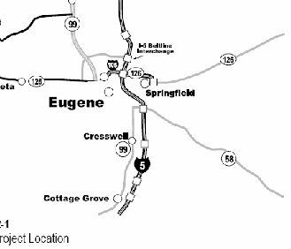
TheI-5/Beltline interchange is located at milepost 195 on I-5, near thenorthern limits of the Eugene-Springfield metropolitan area in LaneCounty, Oregon (Figure 1). The I-5/Beltline Interchange Project isone component of a broader transportation system described in theEugene-Springfield Transportation System Plan (TransPlan). TransPlanis the functional plan of the Eugene-Springfield metropolitan areageneral plan (Metro Plan). Metro Plan establishes the broad frameworkupon which Eugene, Springfield, and Lane County make coordinated landuse decisions. TransPlan guides transportation policy and investmentdecision making in the Eugene-Springfield area.
TransPlanand previous planning efforts identified the I-5/Beltline interchangeimprovement project as one of several key efforts required to createa fully integrated, multi-modal transportation network in the area.This network would support planned growth within the communities ofEugene and Springfield while encouraging a reduction of total vehiclemiles traveled in the metropolitan area.
Sinceconstruction of the original interchange in 1968, theEugene-Springfield metropolitan area has changed substantially.Originally, an agricultural access point to the interstate, the areaaround the interchange is now more residential and commercial (Figure2). I-5 is a major western U.S. north-south route spanningCalifornia, Oregon, and Washington, and connects the U.S. with Mexicoand Canada. I-5 is an international trade corridor and freight route.
Locallyplanned land use recognized the existing and future economicimportance of the area served by the I-5/Beltline interchange. Theinterchange provides access to travel-related services such asrestaurants, lodging, gasoline as well as local residentialneighborhoods and the Gateway Mall. The nearby Gateway area has ahigh concentration of hotels and motels, making it a convenienttravel layover destination. As a result, the operation of theGateway/Beltline intersection materially affects the performance ofthe I-5/Beltline interchange. ODOT and the City of Springfieldmonitored the operation problems at the interchange over many yearsand noted the mismatch between the existing transportationinfrastructure and planned land use. They predicted traffic andsafety conditions to worsen in the future without improvements to theinterchange.
TheI-5/Beltline interchange falls under the purview of 17 federal,state, and local land use plans and policies. The Oregon HighwayPlan (OHP) policy and administrative rules is the most significant interms of shaping specific project alternatives. OHP supports thatODOT and local jurisdictions collaboratively address land use andtransportation issues, especially near interchanges.
Project Overview
I-5runs north-south through the Eugene-Springfield area, with Beltlineintersecting it east-west. The City of Eugene lies to the west ofI-5, with the City of Springfield to the east. The I-5/Beltlineinterchange was originally a cloverleaf with circular loop ramps(Figure 3). In 1970, traffic demand was approximately 20,000vehicles per day, compared to 93,000 vehicles per day in 2000, and aprojected 120,000 vehicles per day in 2015. The interchange serveslarge, regionally significant commercial and manufacturing centersthat in 2005 provided jobs for an estimated 5,000 people today and anestimated 15,000 jobs by 2015. In addition to improvements at theI-5/Beltway interchange, the project includes reconstruction of theGateway/Beltline intersection. The intersection is one-quarter mileeast of the I-5/Beltline interchange in Springfield.
ODOThas studied and evaluated the I-5/Beltline interchange since spring1996, when ODOT initiated a Facility Plan (also called a refinementplan) with local agency and stakeholder involvement. ODOT carriedforward the results of the Facility Plan process in 2000, when thedepartment initiated a structured project development anddecision-making process to evaluate formally project alternatives andimpacts. Due to existing geometric deficiencies, especiallyinsufficient spacing between intersections, ODOT also evaluatedoperational and safety issues at other nearby intersections (such asthe Gateway/Beltline intersection) as part of the I-5/Beltlineinterchange project improvements.
Figure 2. Project Study Area andLand Uses
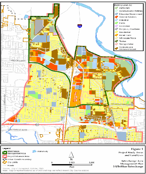
Figure 3. Aerial View ofthe I-5/Beltline Interchange Area
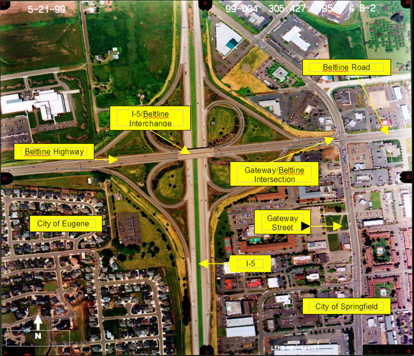
Source: I-5/Beltline Revised Environmental Assessment
Thestructured decision-making process that followed the Facility Planincluded an Environmental Assessment (EA) and led to approval of thefollowing major project improvement elements:
- Anew “flyover” bridge from I-5 northbound to BeltlineHighway
- Anew ramp from I-5 southbound to westbound Beltline Highway
- Newauxiliary lanes to the Beltline Highway-Coburg Road interchange
- Gateway/Beltlineintersection improvements
- Soundwalls along the west side of I-5
- Bridgereplacements and widening
- Newbicycle and pedestrian facilities including a new bike andpedestrian crossing of I-5
Aspart of the project, ODOT had to acquire appropriate right-of-way,requiring relocation of several utilities. The total estimatedproject cost is $113 million. ODOT partitioned the I-5/Beltlineinterchange project into three phases to occur over a period ofapproximately 2006 to 2022. Phase 1 started construction in 2006partially funded with federal, state, and local funds and partiallyfunded with The Oregon Transportation Investment Act funds for the$72.5 million Phase 1 work. ODOT began Phase 1 construction in May2006 and will complete construction in December 2008. Anintergovernmental agreement executed between ODOT and the City ofSpringfield includes traffic monitoring requirements, the results ofwhich would trigger the start of Phase 2. Based on currentinformation, increased traffic volumes have necessitated Phase 2negotiations between ODOT and the City of Springfield earlier thanthe previously estimated 2010 date.
Project Drivers
Asland use and other conditions in the I-5/Beltline area changed withtime, communities and local governments became increasingly concernedwith functional deficiencies of the interchange. These functionaldeficiencies included geometric, operational, and safety aspects.
Geometricaspects include weaving and spacing issues, which inhibit automobilemovement. In the I-5/Beltline area, the short distance between loopramps, where traffic changes lanes, was increasing the magnitude ofconflicts. Operational problems included the geometric deficienciesexacerbated by the relationship of the interchange with the nearbyGateway/Beltline intersection. This relationship caused intermittentcongestion and subsequent delays during peak commuter periods. Thesegeometric and operational deficiencies resulted in safetydeficiencies. From January 1994 to December 1998, more than 175collisions occurred in this area, and 67 percent involved injuries.Despite a 1999 safety improvement, the crash rate at this site was inthe state’s highest 10 percent of all crash locations.
Nearbycommunities identified other concerns. According to communities inthe area, increased traffic levels diminished livability nearby, andled to impacts such as additional noise, degraded air quality, andother associated issues. The City of Springfield also identified theBeltline area as an employment and residential nodal area for futuredevelopment in its economic development and land use plans, and notedthat future development on vacant land in the vicinity would worsenexisting conditions. Some community members also believed theinterchange served as a major barrier to non-automobile modes oftransportation (e.g., pedestrians and bicycles). The interstate andBeltline divide several residential neighborhoods from commercial andgovernmental facilities, as well as employment opportunities. Giventhese issues, ODOT had clear objectives to resolve operational,safety, and community issues with the I-5/Beltline improvementproject.
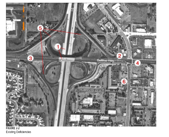
Figure4 shows the major deficiencies associated with the interchange andsurrounding area as identified by the SWG in the I-5/BeltlineInterchange Revised Final Decision Document:4
- Weavesection on I-5 and Beltline between exit and entrance ramps: Increased potential for collision because of limited driver reactiontime (and limited distance between exit and entrance ramps) whenmerging to and from I-5 and Beltline.
- Intersectionspacing between interchange ramps and Gateway/Beltline: Distancesbetween northbound interchange ramps and the signalized intersectionat Gateway/Beltline are insufficient to allow drivers to make lanechanges safely for all movements.
- Lackof accommodation of multi-modal facilities: Insufficient facilitiesto accommodate the bike, pedestrian, and transit, and to satisfy ADAcompliance needs in the area.
- Gateway/Beltlineintersection operations: Increased potential for accidents due totraffic volumes and approaching capacity during peak periods at theGateway/Beltline intersection.
- Substandardhorizontal geometry on loop ramps: Curvature, slope, and grade oframps increase the potential for accidents, particularly for trucks.
- Storagedistance on Gateway: Increased potential for collision as carsblock cross-street intersections and access to businesses because ofGateway traffic waiting to pass through the Gateway/Beltlineintersection during peak periods.
Alocal community group, United Front, was another important projectdriver. The group lobbied for this project, ensuring funding for thestudy and design in the Transportation Equity Act for the 21stCentury (TEA-21). Furthermore, Congressman Peter DiFazio (D-OR), asa ranking member of the Highways, Transit, and PipelinesSubcommittee, supported the inclusion of $20 million for theconstruction of the interchange in Safe, Accountable, Flexible,Efficient Transportation Equity Act: A Legacy for Users (SAFETEA-LU)in 2005.
Figure 4. I-5/Beltline InterchangeDeficiencies
I-5/BeltlineInterchange Project, Decision Document
Initial Concept and Planning
Asnoted previously, ODOT began initial planning and evaluation ofI-5/Beltline interchange improvements with a facility plan in 1996.The intent of a facility plan is to conduct public participationearly in the project planning process and define problems andsolutions. The I-5/Beltline Interchange Facility Plan includedanalysis of transportation issues, traffic forecasting, conceptdesigns and locations, and refined solution costs. ODOT completedcreation and analysis of the design concepts by late 1999. ODOTbrainstormed 20 design concepts for the interchange and recommendedeight to the Facility Plan Steering Committee for further review.After further analysis, ODOT recommended three of the design conceptsfor the project development phase. ODOT also developed six designconcepts for the Gateway/Beltline intersection. The SteeringCommittee advanced two of the intersection concepts, which wereincluded with the interchange design concepts for further analysis inthe EA beginning in early 2000. However, the Steering Committeestrongly disagreed with the original traffic projections as predictedin the Facility Plan. The Facility Plan estimated 80,000 total tripsin 1995 for this study area, with a 2015 projection of 139,000 –145,000 total trips. By contrast, the re-formulated transportationproblem statement estimated average daily traffic volumes of 93,000in 2002 with a projected average of 120,000 by 2017. Given thesediscrepancies, the SWG questioned the necessity for immediateimprovements to Gateway/Beltline intersection, preferring to postponethe related community impacts as long as possible.
Major Project Issues
Stakeholdersidentified the following key issues in interviews conducted by CH2MHILL in February 2000:
- Interruptionto commercial activities during construction;
- Reducedaccess to particular adjacent businesses;
- Needto support future economic development in the area;
- Needto maintain characteristics of the freeway-oriented commercial areathat is appealing to inter-regional freight movers and othertravelers;
- Needto balance needs of future facility users and businesses againstimpacts on current adjacent land uses;
- Needfor realistic assessment of the role transit can play in meetingtransportation needs in the Gateway area;
- Needto consider non-construction costs that differentiate alternativessuch as right-of-way costs, and non-monetary social andenvironmental costs;
- Needfor minimal profiles that reduce impacts to existing businesses;
- Needto improve pedestrian and bicycle features;
- Needfor improved safety for vehicles, pedestrians, and bicyclists;
- Integrationof future transit station and pedestrian access to buses;
- Potentialrelocation, noise, and community disruption impacts to residents ofthe Patrician Mobile Home Park;
- Trafficcongestion that limits access of adjacent neighborhood people tolocal street system; and
- Noiseand air quality impacts to adjacent neighborhood residents
Environmentalissues included wetlands, noise, air quality, visual impacts, landuse, community impacts, and the potential for induced growth. Otherthan the traffic-related deficiencies linked to the environment andnatural resources, environmental issues did not drive the process.Mitigation measures to avoid or reduce potential impacts are in theEA where appropriate.
InstitutionalFramework for Decision Making
Althoughthe Facility Plan Steering Committee had made substantial progress inreaching agreement on conceptual alternatives for the interchange andthe Gateway/Beltline intersection, ODOT recognized that an improvedpublic involvement process was necessary to further develop thealternatives in the EA and gain the support of all stakeholders, bothpublic and private. Therefore, in 2000, ODOT began the highlystructured public and agency project development process (describedherein) leading to the selection of interchange alternatives analyzedin the EA. The entire decision-making process took approximately 3.5years to complete from the beginning step of the formulation ofdecision-making process to the Record of Decision (ROD) by FHWA in2003
ODOT’sconsultant, CH2M HILL, conducted stakeholder interviews to capturekey public perceptions. Interviewees included some SteeringCommittee members who had previously participated in the developmentof the Facility Plan. The interviews revealed that livability andcommunity interests were just as important to stakeholders astransportation performance. To many in the community, the FacilityPlan concepts only met the basic design and regulatory requirementsfor this type of project and thus fell short of what they wanted.
Project Management Structure
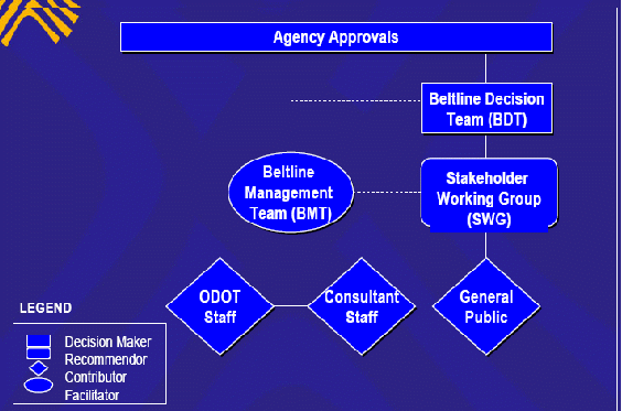
Thenew decision-making process involved three key committees; theBeltline Decision Team, the Stakeholder Working Group, and theBeltline Management Team, with CH2M HILL serving as facilitator(Figure 5).
Beltline Decision Team
Thefive member Beltline Decision Team (BDT) consisted ofthree elected officials and two representatives from each of themajor jurisdictions and agencies with regulatory authority forproject implementation. The BDT set the policy framework for theproject and made final decisions at key milestones in the project.The BDT included:
- SpringfieldCity Councilmember
- EugeneCity Councilmember
- LaneCounty Commissioner
- FederalHighway Administration (FHWA) Field Operations Engineer
- ODOTArea Manager
The title “decision team”was a misnomer that was a point of confusion for some stakeholders. The BDT made non-binding recommendations but FHWA had the finalauthority for decisions on project selection, design, andconstruction. As a result, ODOT no longer uses the title “decisionteam” to identify similar advisory committees to avoidconfusion and distinguish FHWA’s statutory responsibility formaking the NEPA decisions and the BDT’s responsibility formaking recommendations at the various key decision points.
Stakeholder Working Group
TheStakeholder Working Group(SWG)represented a wide range of stakeholder interests including affectedproperty owners, neighborhoods, interest groups, and localjurisdictions. SWG members acted as a communication link betweentheir constituencies and agency decision makers and electedofficials. The following agencies’ and organizations’representatives made up the SWG:
- GatewayOwners for Positive Change
- GatewayMall
- Eugene/SpringfieldChamber of Commerce
- PatricianMobile Home Park
- HarlowNeighborhood
- GameFarm Neighbors
- Friendsof Eugene
- Oregon Truckers
- LaneCouncil of Governments
- LaneTransit District
- Cityof Springfield Engineering
- Cityof Springfield Planning
- Cityof Springfield Planning Commission
- Cityof Eugene Planning
- Cityof Eugene Engineering
- LaneCounty of Engineering
- Cityof Eugene Planning Commission
- FederalHighway Administration
- OregonDepartment of Transportation Engineering
- OregonDepartment of Transportation Planning
- OregonDepartment of Transportation Environmental Section
Beltline Management Team
Technicalexperts from ODOT and CH2M HILL composed the Beltline Management Team(BMT). ODOT staff included the Project Leader, and planning,environmental, engineering staff. CH2M HILL provided support withcomparable counterparts. The BMT served as staff to the BDT and theSWG and provided information and analysis to support project decisionmaking. Figure 5 represents the structure of the decision-makingframework and the roles of the three committees. As discussed in thenext section, the first key decision point included formulation ofthis management structure and decision-making structure.
|
Figure5. Decision-makingFramework and Role Flowchart |
|
|
Source:CH2M HILL 09/06/01
TransportationDecision-making Process / Key Decisions
ODOTstructured the decision-making process to engage public and privatestakeholders at key decision points in the project developmentprocess. To initiate the development of the decision-making process,CH2M HILL conducted stakeholder interviews to gather input on projectissues, scope of work, decision making, and public and agencyoutreach. Individuals interviewed included some members who hadpreviously served on the Facility Plan Steering Committee and hadhistorical knowledge of the controversy surrounding the communityimpacts associated with the recommended alternatives. Stakeholdersinterviewed included a cross section of jurisdictions, electedofficials, special interests, agency staff, and citizens with variedperspectives on the project. These interviewees then became part ofthe SWG for the I-5/Beltline EA. Hour-long interviews with eachstakeholder revealed three major topics of concern: communityimpacts, the need for an integrated citizen-working group, and theneed for a clear decision-making process that ensured localrepresentatives would make the final decision on project elementsthat would have community impacts.
Afterconsideration of the stakeholders’ input, ODOT developed the8-step decision-making process for the I-5/Beltline Interchangeproject. The new structured community-based decision-making processattempted to engage affected community and local and staterepresentatives to reach consensus on a preferred alternative. Thefollowing sections describe the roles of each committee, decisionsmade, information used, and results of specific key decision pointsin the 8-step process.
Step 1 - Formulation of Management Structure andDecision-making Process
Forthe first step, ODOT assembled the SWG, the BMT, and the BDT. At thekickoff meeting, each team developed a chartering agreement thatdescribed the respective team’s roles and responsibilities, howdecisions within the group would be made, communication protocols,and a process for resolving differences of opinion. Each committeeformally adopted their respective operating protocols and each membersigned the agreement to show their commitment to the process and theproject.
Beltline Decision Team
The BDT protocols included regularmeeting times and an understanding that the meetings would be open tonon-members. The BDT reserved five minutes at the beginning of eachagenda for public comment. The team also developed a process forcommunicating with the other committees, federal and staterepresentatives and their constituents, and the media. The majorelement of the BDT protocols was a decisionmaking process that wouldkeep the project moving forward and minimize delays. When it came tomaking decisions, the group agreed to respect and consider eachmember’s point of view and attempt to reach consensus. As agroup, the BDT would first identify points of agreement to reachincremental decisions. The BDT documented minority opinions in aminority report when they could not reach consensus. To reducedelays, the BDT agreed that the team would not revisit decisions,unless significant new information was introduced.
TheBDT made the following recommendations at key decision points basedon the recommendations of the SWG and technical assistance from theBMT:
- Adopt the final transportation problem statement
- Adopt the evaluation framework
- Select alternatives for evaluation
- Select alternatives for detailed evaluation in the EA
- Select a preferred alternative
The SWG’s goal wasto reach decisions by consensus. When the SWG could not reach fullagreement, but dissenters could “live with” thedecision, the record reflected the decision as a consensus decision.
Stakeholder Working Group
Though more detailed, the SWGprotocols were similar to those adopted by the BDT. SWG memberscommitted to participating in the process with an open mind toprovide a fair analysis of the alternatives and produce viablerecommendations to the BDT. Once a member agreed to participate, theywere to attend all meetings or send an alternate. Members who missedmore than three meetings could be removed from membership.5SWG protocols provided guidance for internal and externalcommunications to integrate different backgrounds and expertise withan open and honest dialogue.
The SWG’s goal was to reachdecisions by consensus. When the SWG could not reach full agreement,but dissenters could “live with” the decision, the recordreflected the decision as a consensus decision. When dissenterscould not live with the decision the predominant perspective was anon-consensus decision and the minority perspective reflected in themeeting notes. Those advocating the position drafted minoritypositions in a minority report to the BDT. For the most part, issueswere resolved during the meeting in which the issue was raised, andat least two-thirds of the members were required to be present tomake decisions at key decision points. These decisions became“frozen” unless two-thirds of the membership agreed torevisit the decision.
Beltline Management Team
The responsibilities of the BMT weredescribed in the EA Management Team Charter. The goals for the BMTwere to deliver the EA on schedule and within budget, in compliancewith technical requirements and methods, and with internal andexternal stakeholder satisfaction, understanding, and a positiveexperience.
The BMT managed the day-to-dayactivities of the project, provided project direction, served as thekey points of contact for external partners and the public, andworked with ODOT management to determine the proper course of actionat all stages of project development. The charter included acommunications plan and meeting procedures and clarified theresponsibilities of ODOT and the consultant in the review andapproval process to ensure the development of a high quality EA. Thecharter also included the responsibilities of managers for trackingand monitoring changes in the scope of work, schedule, and budget.
Public Involvement Plan
Inaddition to the BDT’s and SWG’s responsibilities to keeptheir constituents informed on the progress of the project, plannedoutreach activities scheduled throughout the project provided thepublic with opportunities to affect the project outcomes. Although itwas not a formal public involvement plan, per se, the BMT outlinedthe decision-making structure and its public involvement componentsin a memo dated February 2000. As part of the planned outreach, ODOTdeveloped a mailing list of over 500 property owners in the studyarea and updated the list prior to each mailing. The list includedall those who participated in ODOT’s Facility Plan activitiesas well as those who indicated an interest in the EA. Severalnewsletters published during the course of the project providedupdates on project progress to those on the mailing list. ODOT heldfour public open house/workshop meetings (including an openhouse/public hearing during the comment period on the EA) andadditional meetings with landowners, elected officials, andneighborhood representatives of the Patrician Mobile Home Park. Frequently, ODOT held the meetings in workshop format, going beyondthe traditional open house-type meetings. At these meetings, smallgroups worked together to discuss issues using maps and post-it notesfor the public to work through the issues collaboratively and recordtheir ideas at different points in the process. Additionally, for thefirst time, ODOT used an interactive project-specific web page toprovide opportunities for information exchange amongst stakeholders.Specifically, ODOT asked interested persons to provide input on the:
- Problemstatement
- Alternativesevaluation criteria
- Rangeof alternatives to be considered
- Alternativesto be forwarded for detailed analysis in the EA
- Preliminaryanalysis of environmental effects of project alternatives
Step 2 – Definition of the TransportationProblem
For step 2, ODOT presented the SWG asummary of the existing conditions that identified three types ofdeficiencies: geometric, operational, and safety. The initialinformation came from the Facility Plan, but as mentioned earlier,the SWG questioned the validity of the traffic projections. Inresponse, the traffic engineers from ODOT, CH2M HILL, City ofSpringfield, City of Eugene and Lane County consulted andcollaborated to reformulate the traffic assumptions to estimates thatthe engineers and community thought were more reasonable. The trafficmodeling process itself did not change from the Facility Plan to thisprocess; only the underlying assumptions. The SWG requestedclarification or modifications to address their concerns about airquality, traffic operations, system connectivity, and safety.
After a presentation and discussionabout the traffic and community issues, the group took a bus tour ofthe project area to help the members reach a common understanding ofthe problems. After the tour, group members raised a number ofadditional concerns. These included a need for additional informationon the traffic modeling, clarification of traffic data, and SWG’sconcern that the definition of the transportation problem not ruleout the No Build Alternative. Other members requested that ODOT notlimit the problem definition to transportation issues and that ODOTintegrate community issues into the problem definition. The finaltransportation problem statement incorporated these issues which ODOTlater used as the basis for the Purpose and Need statement in the EA.The SWG discussed a list of more than 50 transportation and communityissues. In the course of the discussion, the SWG noted two competingthemes. Some members believed the area was not sufficiently densewhile others were concerned about the impacts of higher densitydevelopment. The group did agree that there was a mismatch betweenplanned land use and the existing infrastructure.
Atthe first public scoping meeting, held in an open house format,citizens provided input on the problem definition, to identifyproject issues, and to brainstorm ideas about additionalalternatives. Following this public input, the SWG made a consensusdecision to recommend the problem definition to the BDT for theirapproval and the BDT concurred. The problem definition became thefoundation of the purpose and need statement for the EA.
Step 3 - Development of Alternative EvaluationFramework
Thethreshold criteria represented the minimal conditions of acceptance.
Threshold Criteria
Once the SWG defined thetransportation problem, the group created an evaluation framework asa tool to support the decision-making process. The SWG established“pass/fail” thresholds to screen out technicallyinfeasible alternatives. The criteria consisted of federal, state,and local requirements in four major categories:
- Consistencyof interchange and intersection form with the American Associationof State Highway and Transportation Officials (AASHTO) geometricdesign forms;
- Consistencywith applicable federal regulations and the Oregon Highway Planpolicies;
- Abilityto implement the alternative in phases and improve safety; and
- Compliancewith FHWA Interstate Access Policy.
The threshold criteria represented theminimum conditions of acceptance and alternatives that could not meetthe criteria were eliminated from further consideration.
Evaluation Criteria
Toevaluate the performance of feasible alternatives, the SWGcollectively developed a list of 26 evaluation criteria in fivebroad categories: cost, implementation, transportation, safety, andthe natural and human environment.
TheSWG established criteria to evaluate the performance of feasiblealternatives against the full range of stakeholder values, and then used the criteria torank the alternatives. Using input from the first public open house,the group brainstormed a list of about 40 criteria in five broadcategories including cost, implementation, transportation, safety,and the natural environment and human environment. After furtherconsideration the group suggested six additional criteria toqualitatively evaluate the impacts: the alternatives had to be ableto be phased; improve safety for all modes; accommodate thecommercial district and provide access to businesses; accommodatealternative modes such as pedestrian, bike and transit; and minimizeproperty displacement.6
The SWG finally reached consensus on alist of 26 evaluation criteria, including performance measures foreach one (see Appendix A). Where feasible, measurements werequantitative, such as acres of wetland impacts or the number ofbusiness displacements. Other measures were qualitative, establishinga high, medium, or low scoring scale based on relative desirablecharacteristics such as the connectivity of bike/pedestrian/wheelchair facilities and accommodation of transit. The BDT approvedthe evaluation framework as recommended by the SWG.
Step 4 - Formulation of Alternatives
TheI-5/Beltline Interchange Facility Plan examined a broad range ofalternatives and the Steering Committee suggested additionalalternatives at the end of the process. At the initiation of theI-5/Beltline EA, engineering and planning representatives from ODOT,the City of Eugene, the City of Springfield, Lane County, LaneTransit District, and the Lane Council of Governments (LCOG) held afunctional planning workshop to validate the results of the FacilityPlan. The results of this analysis identified a family of potentialalternatives for the interchange, but the intersection treatmentswere less conclusive. Using AASHTO’s functional planningmethodology for geometric design and ODOT’s standard trafficmodeling processes, the group developed three categories ofinterchange forms and eleven interchange concepts. These resultsbecame the starting point for the SWG’s formulation ofalternatives.
Beforethe SWG began reviewing alternatives, ODOT provided the grouptraining on the basic principles of interchange design. Usingsingle-line drawings superimposed on aerial photos, ODOT provided theSWG 10 alternatives for their initial consideration and the groupsuggested additional alternatives.7 At this stage, the SWG considered these conceptual plans anappropriate level of detail for comparing the alternatives againstthe threshold criteria. The interchange alternatives were groupedinto three categories relative to form and function. The categoriesincluded:
- Free-FlowAlternatives – free flow of traffic in all directions athigher speeds;
- System/ServiceAlternatives – would treat Beltline west of I-5 as a freewayand Beltline east of I-5 as an arterial street; and
- SplitForm Alternatives – tailored to meet the system requirementsof Beltline west of I-5; I-5 access to the east would occur throughsignalized intersections.
TheSWG identified two options for the Gateway/Beltline intersection:
- Gradeseparated – Five possible alignments to physically separateGateway Street and Beltline Road; and
- Atgrade – Three options for keeping Gateway Street and BeltlineRoad physically connected.
Thegroup then considered the travel characteristics and benefits of eachoption. SWG members requested that ODOT formulate the geometricdesign of alternatives to consider the unique standards for trucktraffic in Oregon, which allow longer and heavier vehicles than inother states. Prior to the public presentation, ODOT technical staffrefined the alternatives, giving SWG members the option ofparticipating in the effort.
Atthe second public meeting, conducted in a workshop format, citizensprovided input on the proposed alternatives and suggested additionalalternatives. SWG members actively participated in facilitation ofthe discussions and answered questions.
Majorissues identified from the public meeting included:
- PatricianMobile Home Park residents were very concerned about losing theirhomes. Those attempting to sell their homes were having difficultydue to uncertainties about the impacts of the project;
- Thepublic had difficulty understanding the written materials and linedrawings;
- Participantsdid not have enough time to absorb the information;
- Participantshad difficulty connecting alternatives with specific impacts;
- Participantswanted the opportunity to mail back comments;
- Participantssupported the need to fix problems identified on the maps; and
- Impactsto businesses by a grade separation of Gateway and Beltline weremore of an issue than the grade separation itself.
Step 5 – Threshold Screening ofAlternatives
TheBMT applied the threshold criteria to the interchange alternativesand presented the results to the SWG for review. The SWG reviewed theinformation and discussed each category. One alternative wasdismissed and six were determined not feasible. In addition, the BDTeliminated one other alternative due to concerns about the impacts tothe Patrician Mobile Home community.
Thedecision to eliminate one alternative followed a nine-five vote bythe SWG that, per the protocols, was a consensus decision since thedissenting members did not indicate they could not “live with”the majority opinion. However, at least one member felt pressured bythe group to reach consensus.
Forthe threshold screening of the intersection options, the SWGpreferred to evaluate at-grade intersection combinations first. Ifthey failed to meet the threshold criteria, then the grade-separatedoptions would be evaluated. Otherwise, the at-grade options wouldautomatically be forwarded to the evaluation phase. The minorityreport in this step favored elimination of all grade-separatedoptions and consideration of only one at-grade option for theGateway/Beltline intersection because of extensive commercial andresidential impacts. The Gateway Owners for Positive Change (GOPC), agroup comprised of Gateway-area business and residential propertyowners, expressed their concerns throughout the project aboutpotential economic impacts and disruptions to traffic movements inthe Gateway area, and stated they would endorse only one at-gradeintersection option.
Followingdetermination of feasible interchange alternatives, the BMT used aquantitative approach to pair interchange/intersection combinationsfor evaluation. The quantitative method considered the operations ofthe Gateway/Beltline intersection with and without other localroadway improvements to determine if the 20-year design lifethreshold could be met. The intersection option, favored by GOPC, didnot meet the 20-year design life threshold and was eliminated.
Afterelimination of the GOPC alternative, the BMT worked in collaborationwith an engineer hired by GOPC to identify options for a conventionalintersection that would avoid displacement of businesses and meet thethreshold criteria. The resulting alternative was in agreement withGOPC that right-of-way acquisition would be acceptable if it did notcause a business or residential displacement; access consolidationwould be acceptable; and circulation and travel patterns would bewell signed to accommodate the movement of truck traffic to accessindustrial properties. This new intersection alternative was includedin the range of alternatives recommended to the BDT.
TheBDT concurred with recommended interchange alternatives, buteliminated intersection options that would result in the displacementof residents in the Patrician Mobile Home Park. The justification wasto provide residents in the mobile home park a measure of certaintyduring their retirement years. The final range of alternativesapproved by the BDT included 20 combinations of five interchangeforms and six intersection forms.
Step 6 – Selection of Alternatives for theEA
Followingapproval of the range of alternatives in Step 5, ODOT began theprocess of narrowing down the list of alternatives by applying theevaluation criteria.
Data Collection
First,technical staff conducted data collection to serve twopurposes—gathering data for screening alternatives against theevaluation criteria and for later the EA analysis. Literature reviewsand field reconnaissance surveys assisted in the quantification ofimpacts to the natural and social environments. Local land use plansand statewide planning goals were also reviewed to understandexisting and planned land use. Census data was used for thesocioeconomic analysis. ODOT used the Statewide Implementation Plan,which is approved by the Oregon Environmental Quality Commission, USEPA, and the Lane Regional Air Pollution Authority to document airquality conformity. ODOT technical experts took noise measurements at28 residential and business locations near the I-5 interchange andGateway/Beltline intersection.
Performance Rating
This data was usedto analyze the twenty alternatives against the 26 evaluationcriteria. A performance rating was developed for each alternativeagainst each criterion. Two of the 26 criteria, historic resourcesand neighborhood cohesion, were eliminated from the analysis afterthe data collection because they provided no differentiation amongalternatives. A third criterion, impacts to critical habitat, wasalso eliminated from the evaluation due to the time and level ofeffort required to collect needed data. However, based on awindshield survey and review of listed species, no fatal flaws forcritical habitat were identified for any of the alternatives.
Ratingsfor each criterion were normalized on a scale of 1.00 (best) to 0.00(worst) to create comparable data for use in the ranking calculation.The BMT and other technical staff provided the SWG with the methodsused to rank the alternatives. The technical staff created therankings through a variety ofmathematical quantitative analyses using the extensive datacollected. ODOT held an open house for SWG members where technicalstaff members were available to answer questions regarding theratings and explain the differences among alternatives.
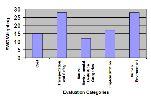
Criteria Weighting
Then, the SWG establishedweights for each criterion to determine their relative importance. Anominal group technique was used in a workshop setting for thisexercise. First weights were set for the broad criteria categories,and then for each criterion within each category. Weights for thecriteria categories are shown in Figure 6.
|
Figure6. Relative Weights |
|
|
|
Source: Recreated from Alternatives Evaluation and Technical Report forI-5/Beltline Interchange |
Alternative Ranking
Followingthe SWG’s weighting workshop, the performance ratings and therelative weights were entered into an interactive decision-makingsupport tool, Criterium® DecisionPlus®. The softwaredisplays the calculated ranking of the alternatives. Based on ananalysis of the contribution of each performance measure to theranking outcome, six criteria were shown to be the most significantin affecting the ranking of alternatives:
- Totalproject cost
- Businessdisplacements
- Motorizedvehicle safety
- Constructionphasing costs
- Safetyimprovements
- Mobilityat intersections
Sensitivity Analysis
Usingthe decision software, the SWG performed a sensitivity analysis. Thegroup used test scenarios to determine potential affects on thealternative rankings. Sensitivity testing focused on three of theSWG’s main concerns: cost, mobility, and safety. “What-if”scenarios examined combinations of the six criteria related to thesetopics. For example, “what if cost were not a factor, wherewould the alternatives rank?” This process verified that therewere no outliers in the data, disproportionately affecting any of theperformance ratings.
Afterreviewing the ranking results, the SWG decided to seek public opinionon the top ranked alternatives before making a recommendation to theBDT on the alternatives for the EA. ODOT held a public open house topresent the SWG’s eight highest ranked alternatives. Afterwards, the SWG evaluated the public comments and recommended oneinterchange alternative and three Gateway/Beltline intersectionoptions for analysis in the EA. The BDT approved this recommendation.
Step 7 – Environmental Assessment
Alternative Refinement
Followingthe public open house, the SWG and the BDT provided ideas for therefinement of the Build Alternative and intersection options forevaluation in the EA. Recommended refinements included:
- Definingright-of-way requirements and property impacts, and accessmanagement;
- Developmentof a bike and pedestrian structure crossing I-5 to provide a safe,non-motorized connection between the Willakenzie neighborhood andthe commercial district;
- Developmentof a mitigation strategy to minimize light and glare impacts onneighborhoods adjacent to the highway;
- Determinationof the locations for sound walls and retaining walls; and
- Formulationof a “best case” conventional intersection with allmovements at the Gateway/Beltline intersection.
Alternative Analysis
TheNo Build Alternative provided a benchmark against the BuildAlternatives. In addition to the Build Alternative discussed above,the EA analysis also included Transportation System Managementmeasures such as ramp metering, High Occupancy Vehicle lanes andoptimization of traffic signal timing. ODOT also consideredTransportation Demand Measures, ridesharing, Bus Rapid Transit, andmass transit, and found that these did not meet the purpose and needor were already available through the Lane Transit District.
Theenvironmental analysis showed impacts to the natural environment werenot a major factor because the land surrounding the interchange wasalready built out. Impacts to low quality wetlands and impacts towater quality from stormwater runoff were the key issues and the EAincluded conceptual mitigation plans for these impacts.
Withthe input of the SWG, ODOT reduced or eliminated some of the issuesthat were initially controversial through examination of a range ofalternatives and design refinements.
Expected impacts from the project were primarily to the humanenvironment. Major issues included noise impacts to residences andseveral nearby hotels, induced development, and business andresidential relocations. ODOT recommended noise mitigation in theform of sound walls for several locations with the final decision onthe installation of sound walls upon completion of project design andthe public involvement process. Concerns about induced land usechanges were addressed in the EA analysis by matching transportationmodeling with adopted land use plans and the Lane Council ofgovernments TransPlan model. Acquisition of property needed forright-of-way had to comply with the federal Uniform RelocationAssistance and Real Property Acquisition Policies Act, butdisplacements remained a concern.
Withthe input of the SWG, ODOT reduced or eliminated some of the issuesthat were initially controversial, such as impacts to the PatricianMobile Home Park and nearby businesses, through examination of arange of alternatives and design refinements. Benefits of the projectas identified in the EA included reduced congestion, and improvedmobility and safety of the I-5/Beltline Interchange.
TheFHWA and ODOT approved the EA in the spring of 2002, and the publicprovided comments during a 45-day public comment period that includeda combined open house and public hearing. ODOT received 306 writtenand oral comments. Of the comments that indicated a preference,nearly all preferred the No Build Alternative as their first choice.Most of the comments generally supported the I-5/Beltline interchangeimprovements but continued to express concerns that impacts from allof the Gateway/Beltline intersection options were too great.Additionally, public comments included substantial concern aboutnoise levels in two neighborhoods where sound walls were notproposed. Others indicated the EA did not adequately address otherprojects and growth in the study area.
TheSWG reviewed a draft compilation of the public comments and ODOT’sresponses. ODOT included the public's suggestions and comments in thefinal version of the Response to Comments and incorporatedappropriate changes into the Revised Environmental Assessment (REA).
Step 8 - Selection of Alternative and RevisedEnvironmental Assessment
InNovember 2002, ODOT produced an internal recommendation report, theI-5/Beltline Interchange Project Final Decision Document. Thereport provided FHWA and ODOT decision makers a comprehensive summaryof the project history including an overview of accomplishments inSteps 1 through 7 and an analysis of the public comments on the EAwith ODOT’s responses. ODOT identified their preferredalternative and provided the Decision Document to FHWA for the finaldecision.
Afterevaluation of public comments on the EA, ODOT and the SWG identifiedfive major remaining community issues. Evaluation of these issues bythe stakeholders and related decisions by the project decision teamwere incorporated into the REA. The five issues included bothprocedural and substantive elements:
- Noise- Several community/neighborhood groups were concerned about trafficnoise levels at their homes and nearby neighborhoods. Harlowneighborhood representatives requested either a sound wall or a peerreview to verify ODOT’s noise measurements and application ofthe noise criteria as represented in the EA were technicallycorrect. ODOT recommended a sound wall for the Patrician Mobile HomePark in the Game Farm neighborhood. However, members of the publicremained concerned that the reflected noise rebounding from the wallwould increase noise levels for other Game Farm residents. As partof the REA process, ODOT stated its intention to build the soundwall and perform additional field noise measurements aftercompletion of construction to determine additional mitigation.
- PeaceHealth– Early in the EA process, a new PeaceHealth hospital,originally planned for Eugene, moved to a Springfield location justeast of the I-5/Beltline interchange. The Springfield site was to bea “node” or mixed-use village with limited emphasis onautomobiles. Comments on the EA included concerns about impacts fromincreased traffic and development, and other impacts of the proposedPeaceHealth development in the Springfield location on the operationof the interchange and the adequacy of the technical work related tothe land use application by PeaceHealth. ODOT’s response tothese concerns was perceived by some SWG members to dismiss thepotential development based on process rather than dealing with thecontent and substance of the matter. However, ODOT did not havesubstantial information about the proposed PeaceHealth project andtherefore deemed the department’s response to communityconcerns to be appropriate and valid for the specific point in timeduring the I-5/Beltline Interchange decision-making process. ODOTwas obligated and stated its intention to respond to PeaceHealthissues, and specifically to the developer’s application,through the land use process. The hospital is now under constructionin Springfield with a planned August 2008 opening.
- Phase2 Implementation – ODOT and FHWA opposed the SWGrecommendation on the preferred alternative because of particularlanguage concerning Phase 2 implementation. After negotiation andclarification, ODOT was able to shift its project designresponsibilities from the state to the City of Springfield, whichwould then take primary responsibility for implementation regardingthe Gateway/Beltline intersection as a city street.
- IntergovernmentalAgreement (IGA) Process – Modified Phase 2 implementationlanguage proposed by ODOT introduced the need for an IGA. Thepurpose of the IGA was to specify performance criteria (triggers)for the implementation of Phase 2 improvements acceptable to FHWA,ODOT, and the City of Springfield. FHWA stated that it could notapprove an REA without this IGA to ensure safety and operationaleffectiveness of the improvements. All parties signed the IGA priorto FHWA approval of the REA.
- TransportationImprovement Costs – FHWA could not take action on theI-5/Beltline Interchange until the REA and local plans wereconsistent with either a “build” or “no-build”decision. While TransPlan incorporated the interchange project, theplan allocated fewer dollars to it than needed to construct allthree phases of the preferred alternative. However, only projectphases 1 and 2 were needed to meet safety and operations goalsduring TransPlan’s 20-year planning period. The estimatedproject construction costs of phases 1 and 2 were within theconstruction amount allocated in TransPlan. Therefore, FHWA was ableto conclude that the project was consistent with TransPlan policiesas well as with land use and transportation modeling assumptions.ODOT will add Phase 3 of the project to TransPlan during futureperiodic reviews and updates.
TheREA provided responses to public comments and related revisions tothe EA, and documented consistency with state and local land useplans. The REA also described the impacts of the preferredalternative and conceptual mitigation measures, including wetlandmitigation plans. The US Fish and Wildlife Service and the US ArmyCorps of Engineers reviewed the conceptual wetland mitigation planproposed in the REA. ODOT completed final wetland mitigation plansduring the final design process, and submitted the permit applicationfor the Section 404 of the US Clean Water Act and the Oregon RevisedStatutes permit prior to starting construction of Phase 1.
Withthe SWG’s input and the BDT’s approval, the REAidentified the Interchange Build Alternative and Option 3 forreconstruction of the Gateway/Beltline intersection as ODOT’spreferred alternative. Together, the REA and the Finding of NoSignificant Impact were submitted to FHWA for approval.
FHWAapproved the Finding of No Significant Impact on July 2, 2003, thuscompleting the 8-step decision-making process.
Lessons Learned
Oregonlaw requires public participation in land use planning. OregonAdministrative Rules (OAR) 660-015-0000(1) requires the governingbody, in this case ODOT, “to develop a citizen involvementprogram that insures the opportunity for citizens to be involved inall phases of the planning process,” including outreach,communications, financial resources, and substantive citizeninfluence at all stages of the planning process. Between 1996 and2000, ODOT developed a Facility Plan that met the basic statutoryrequirements, but the recommended alternative resulted in strongopposition from local governments and citizen stakeholders.Jurisdictional issues, as well as philosophical ones, made theproject particularly complex. Governmental responsibility was splitamongst the federal government, state government, one countygovernment, and two local cities. ODOT recognized a new approachwould be needed to complete the EA successfully. The I-5/BeltlineDecision Process and development of performance measures based onstakeholder values were successful in achieving consensus andidentifying a solution.
However,as is common with complex projects like the I-5/Beltline InterchangeEA, stakeholders had conflicting perspectives about whether or notparticular factors were considered a success or a barrier which oftendepended on the agency’s or organization’s mission. Thestakeholders’ disparate goals made it difficult for everyone tocome away from the table feeling their interests had been fullyaddressed.
Strategic Plan to Move Past Ardent Disagreements
Fundamentally,the SWG gave this project its Context Sensitive Solutions (CSS)component; the locals were able to provide the local context forthis project as they developed the evaluation criteria andperformance measures based on community values.
The structured approach to identifying stakeholder issues,developing performance measures, and sharing decision-makingresponsibility with local and county governments allowed ODOT to movepast the ardent disagreements on the alternatives recommended in theFacility Plan and to reach consensus on a solution that met the needsof most stakeholders. In the beginning, few thought this would bepossible. Fundamentally, the SWG gave this project its ContextSensitive Solutions (CSS) component; the locals were able to providethe local context for this project through the development of theevaluation criteria and performance measures based on communityvalues.
Involving Opponents and Other Early, CreativeStakeholder Involvement
ODOTrecognized the importance of early involvement of all affectedparties, including opponents, and made them stakeholders in theproject. To initiate the process, ODOT and CH2M HILL conducted asurvey of known stakeholder representatives to gather input onproject issues, scope of work, decision making, and public and agencyoutreach. These representatives then became a part of the SWG,ensuring the final decision included input and consideration of theirissues and ultimately reducing public opposition to the I-5 BeltlineInterchange project.
Formal Agreement on Decision-making Process
TheBDT members signed an agreement that established protocols forcommunications and decision making. The BDT also made decisions by amajority vote with written documentation of minority opinions.Limiting the size of the BDT to five members made it easier to reachconsensus, but it would have been more efficient had all members hadthe authority to make final decisions without having to go back totheir respective agencies for final approval.
Similarly,each member of the SWG agreed in writing to a set of protocols forcommunication and decision making which created an atmosphere ofinclusion and eventually trust. The protocols formalized the processfor decision-making authority and ground rules for meetings includingturning off cell phones during meetings; meeting attendancerequirements; roles and responsibilities in the process; an agreementto keep and open mind and be respectful of others’ point ofview; and an agreement on how to include minority opinions when thecommittee could not reach consensus.
Fromthe group’s inception, the SWG understood they were an advisorycommittee. Everyone in the SWG had the opportunity to voice theirconcerns even when they did not necessarily agree with a particulardecision. The BDT assured the SWG they would listen to their concernsand recommendations before making a decision. As the SWG undertookvarious tasks, members became integrated into the group setting ofrespectful discourse and deliberation.
AllSWG members participated and contributed to the meetings and the CH2MHILL facilitator kept any one person from dominating the discussions.At each decision point, decisions were majority vote with dissentingopinions documented in a Minority Report, which was provided to theBDT before making a final decision. This not only allowed everyone tohave his or her issues considered but it also kept the process fromgetting stuck on any particular issue.
Nevertheless,there were considerable questions about the fairness of thecomposition of the SWG, with some group members stating that theirissues were not equally addressed. The SWG’s membership heavilyfavored transportation planning and engineering professionals andincluded very few volunteer community members. The group included onerepresentative from each affected neighborhood and no representativesfrom environmental resource agencies. Some members felt the majoritywas predisposed to an outcome primarily driven by economicdevelopment or AASHTO engineering design standards. An additionalbarrier to increased community involvement was the meeting day andtime on Tuesday afternoons, which is an inaccessible time for manycitizens.
Shared Decision Making
TheI-5/Beltline Interchange project was ODOT’s first experiencewith this type of shared decision-making process, though CH2M HILLhad previously used similar processes. The process was unique forthis project, and it brought together people who held very polarizedpositions when the process began. One of the most unusual aspects ofthis project was the shared power on the BDT. The composition ofmembers was majority-ruled by the local governments. Collectively,Lane County, Springfield, and Eugene’s views outweighed thestate and federal government. It is unusual for local governments tohave this much influence when they are not funding the project. Fromthe local perspective, it was critical to have elected officials makedecisions affecting the community; from ODOT and FHWA’sperspective, they held responsibility for addressing thetransportation needs of non-local motorists as well as localstakeholders.
Nevertheless,when FHWA and ODOT disagreed with the local stakeholders on thedesign of the Gateway/Beltline intersection, ODOT followed the BDTprotocols, and submitted a Minority Report in support of agrade-separation at the Gateway/Beltline intersection. Statutorily,FHWA and ODOT held responsibility and authority for making finaldecisions on the preferred alternative and could have required agrade-separated intersection, but without local support, the projectwould have ended in a stalemate. Local officials held accountableby their constituencies felt responsible for making decisions in thebest interest of their citizenry. When it came to selecting apreferred solution for the Gateway/Beltline intersection,decision-making authority became a point of contention betweenFHWA/ODOT and the local governments. Since the I-5/BeltlineInterchange project, ODOT no longer uses the title “decisionteam” for similar advisory committees to eliminate confusionas to who is responsible for making decisions and who is responsiblefor providing input and making recommendations.
Althoughnot all parties were happy with the final decision, nearly allparticipants in both the BDT and SWG agreed the process worked welland felt it resulted in a more transparent decision-making process. Stakeholders remarked that if ODOT had started this structureddecision-making process during development of the Facility Plan, theEA would have been completed much sooner, thereby reducing theopportunity for distrust and confusion to build. ODOT has sincereplicated the structured decision-making process on other projects,most notably the Willamette Bridge renovation north of Eugene.
Establishing Threshold Criteria
Theexistence of criteria to determine if an alternative was feasible ornot, developed through a public process before alternatives weredeveloped, proved to be very important. Local business interestsfavored an intersection alternative that had no impacts on existingbusinesses. Analysis of this alternative showed that it would notmeet the threshold criterion relating to FHWA’s policyrequiring that projects meet needs for a 20-year planning period. Thefavored alternative would meet needs for part of the period, but notall of it. Only after the alternative was eliminated did thatstakeholder group give up its positional bargaining and engage inactive problem solving to develop an alternative that could beforwarded for further analysis.
Decision-Support Software
Akey element of the decision-making process was the decision supportsoftware, Criterium® DecisionPlus®, which used amulti-attribute utility analysis to evaluate and compare alternativesbased on community values as represented by the SWG. The decisionsupport software helped keep the focus on the objectives of theproject and incorporated stakeholders’ values into thedecisions. The SWG developed criteria driven by their interests andthe weighting process helped the group focus on the issues ofimportance to the community. As a result, the SWG did not waste timeon issues that were unimportant or that would not change theperformance of the alternatives. Ultimately, this approach todecision making enabled sharply divided jurisdictions to developshared ownership in the process and the outcome.
Conversely,some SWG members felt strongly that the weighting process did notrepresent a fair balance of community values and engineeringcriteria. According to these members, the weighting process put moreemphasis on the technical and engineering aspects and therefore, theybelieved, pre-determined the outcome. Additionally, some also thoughtthe selection of the SWG members was a kind of weighting in itselfbecause the number of transportation professionals outnumberednon-transportation representatives. Those members that were in theminority were also in the minority when the group voted on therelative weight of the criteria. Thus, the members believed theirinput was less influential on the final decisions.
TheSWG used information from the decision software to aid its discussionabout which alternatives should be forwarded for evaluation in theEA. Specifically, the tool was helpful in identifying thosealternatives that least met community values (the lowest scores) andthose few that merited more consideration (the highest scores). Thetool supported discussion, but the evaluation results were not viewedas “the answer.” The SWG’s recommendations resultedfrom creating hybrids of several options that scored well in theevaluation.
Success Factors
Early and Continued Involvement of Stakeholdersand a Transparent Decision-making Process Resulted in CommunityAcceptance of the Project
ODOTand CH2M HILL took several steps to overcome public opposition bybringing together a diverse group of local officials, neighborhoodand business representatives, and technical experts that collectivelyrepresented federal, state and local interests, including supportersand opponents of the project:
- CH2MHILL conducted stakeholder interviews to identify all the communityissues before beginning the NEPA analysis to eliminate surprises atthe end of the process;
- SWGmembers participated in public meetings, presented the outcome ofthe SWG decisions at key decision points, and answered questionsfrom the public. As members of the community involved in the detailsof the decision-making process, their active participation increasedpublic trust;
- Usingthe structured decision-making process stakeholders developedevaluation criteria and performance measurements based on communityvalues. This process exceeded minimum NEPA requirements for publicinvolvement and resulted in community-wide acceptance of the projecteven though not everyone agreed with the solution;
- ODOTformalized a hierarchical public involvement process with definedroles and responsibilities for each project committee, with groundrules governing conduct for each. The committee groups developedthese protocols in their initial chartering sessions and all memberssigned them as the first step in their involvement in the projectdevelopment process;" and
- TheI-5/Beltline Interchange is one of the first EAs to be uploaded forcomment and viewing on the ODOT website, which increased opportunityfor public participation.
Site Visits to Reach Common Understanding ofEngineering and Community Issues
Thesecond key decision point for the SWG was development of thetransportation problem that would later become the basis for thepurpose and need statement in the EA. SWG members disagreed about howwell traffic model results represented actual site conditions. Tohelp reach a common understanding of both the traffic problems andcommunity concerns, the SWG embarked on a field trip to theintersection to understand the interplay between actual trafficvolumes, signal timing, left hand turn opportunities, signage,pedestrian access, and the impacts of different alignments on privateand commercial properties.
Use of Aerial Photos
Anothertool involved switching from engineering line sketches to full aerialpictures with markers. Overlaying the alternatives on the aerialphotos helped all of the SWG participants visualize the communityimpacts of the project. For example, it was easy to see how a turnradius that met design standards also had important impacts to alocal hotel.
Training in Transportation Terminology toFacilitate Maximal Participation by Lay Persons
Priorto technical discussions to develop the definition of the problem,the range of alternatives, and screening of the alternatives, ODOTand CH2M HILL provided the SWG training and information in lay termsso that everyone could participate in the discussions.
Adding to Resource Agency Capacity to StreamlineClearance Process
Formore than five years, ODOT has funded positions at a number of theresource agencies and this staff has become an extension of the ODOTteam. The staff functions as a liaison to prioritize ODOT projects,review the accuracy of ODOT’s work, and assure the resourceagencies have staff capacity to provide consistent and timelyclearances. These staff only work on ODOT projects, thus their focusis on providing the opportunity to build a good workingrelationships, increasing understanding of transportation andresource agency processes, and raising trust between ODOT and theagencies.
Seasoned Consultant Staff and Beltline ManagementTeam
Intervieweesconsistently praised CH2M HILL for keeping the SWG on task and movingthrough the decision-making process. CH2M HILL conductedwell-organized meetings, provided review materials on time, andtranslated technical information into understandable terminology forcommittee members unfamiliar with the transportation projectdevelopment process. The CH2M HILL facilitator did not allow anyoneto dominate conversations and everyone was encouraged to participate.CH2M HILL clearly laid out the decision points and did not allow theprocess to proceed until the SWG reached consensus. Because theprocess focused on stakeholder needs and not solutions, members wereable to give up positions or stances and focus on development of aninclusive list of evaluation criteria that was agreed on by allcommittee members. Stakeholders noted that the process took a lot oftime up front, but the time was well spent to reach consensus andlikely prevented a legal challenge in the long term.
Barriers and Solutions
Neighborhood Noise Impacts
Trafficnoise Impacts to adjacent neighborhoods was a defining issue. The EAanalysis showed that the neighborhood areas did not meet thethreshold criteria for mitigation, specifically sound walls. TheHarlow neighborhood questioned the adequacy of ODOT’s analysis,requested an independent analysis, and threatened to sue ODOT toobtain sound walls. At public meetings, the neighborhoodsoverwhelmingly favored the No Build Alternative. In fact, of the 306public comments on the EA, 252 indicated the No Build Alternative wastheir preferred alternative (However, not all No Build preferenceswere related to noise impacts). Nonetheless, ODOT could not set aprecedent for constructing sound walls that did not meet the federalabatement criteria. However, further analysis of construction impactsshowed noise mitigation was warranted for one of the neighborhoods.For the remaining areas, ODOT agreed to perform post-constructionnoise level measurements. If the area meets the federal criteria fornoise mitigation, ODOT will either include the mitigation in asubsequent phase of the I-5/Beltline Interchange project or constructsound walls as a separate project depending on timing and funding.ODOT’s agreement to conduct a post-construction noise analysisand commitment to mitigation, if warranted, was a uniquely creativesolution to overcome significant public opposition.
Gateway/Beltline Intersection
ODOTand FHWA could not reach consensus with the SWG on the preferredalternative for the Gateway/Beltline intersection. In order for ODOTto meet AASHTO design standards for the intersection a number ofbusinesses would be displaced; an impact strongly opposed by thecommunity. The challenge was to balance the competing priorities ofbusinesses and residents with FHWA and ODOT’s responsibility toensure safety and operational effectiveness of the I-5/BeltlineInterchange for the traveling public. Indeed, the issue requiredresolution before the FHWA could approve the REA and FONSI. Throughan innovative Intergovernmental Agreement (IGA), ODOT and FHWAshifted the project design responsibilities to the City ofSpringfield. The IGA specified performance criteria (triggers) todetermine when improvements of the Gateway/Beltline intersectionwould be required. Under the IGA, ODOT and the City of Springfieldagreed to monitor traffic conditions. When the conditions meet theperformance criteria, the city is obligated to begin design andconstruction of the intersection improvements. The city isresponsible for all construction costs and compliance with allapplicable regulations. FHWA could not approve the FONSI without thisagreement.
Conflicting Local Land Use Planning Objectives
TheI-5/Beltline interchange project is located within theEugene/Springfield urban growth boundary (UGB). The Cities ofSpringfield and Eugene have philosophical and political differencesabout land use planning objectives. Eugene is concerned about inducedgrowth and sprawl and does not want to press the urban growthboundaries. The primary issues for Eugene are noise in theneighborhoods, a strong desire to reduce reliance on the automobilefor local trips with improved connectivity of off-roadway bicycle andpedestrian facilities, and preservation of open space. In the City ofSpringfield, however, the interchange is an important commercial areaand employment center designated for future growth. These differencesled the City of Springfield to petition the state legislature forcontrol of its own UGB independent of the City of Eugene.
Throughthe collaborative decision-making process, the SWG and BDT developedgood working relationships and once into the details of the project,they discovered common ground between the two communities to reachconsensus on the preferred alternative. Common concerns about noiseimpacts and the relocation of businesses and residences brought thecommunities together in support of a solution that reduced communityimpacts.
Lack of Understanding of Federal Requirements forNEPA and Right-of-Way Design Standards vs. Community Impacts
Amajor obstacle was whether to use state or local standards for designof roadways at the junction of interstate and local roads,specifically the Gateway/Beltline intersection. Use of statestandards would have increased the footprint and required acquisitionof large amounts of right-of-way and removal of residential andcommercial access points. The City of Springfield has differentacceptable levels of performance than ODOT and FHWA standards andthey were willing to accept higher levels of congestion to avoidadditional impacts to businesses and residents. Local stakeholdersbecame frustrated with what they perceived as ODOT’s and FHWA’srigid right-of-way requirements, design standards, and the extent towhich these could preclude community concerns. One stakeholder statedthat early and better education with regard to federal and staterequirements and procedures might have helped avoid some of theconflicts.
Innovative Solutions
Documented Concurrence of Consistency withFederal, State, and Local Land Use Plans and Policies
Initially,the PeaceHealth hospital was to be located in Eugene near availabletransit facilities. However, early in the EA process PeaceHealthchanged plans to locate the hospital in an area without access totransit. PeaceHealth had not completed development plans, including atraffic analysis, at the time the REA was being completed. This wasproblematic because Oregon law requires land use planning andtransportation planning be integrated and FHWA required the REA toconfirm that the preferred alternative was consistent with regionaland local land use plans before the FONSI could be approved. The EAhad identified impacts to land use, but for the first time in thisformat, the REA included a detailed analysis and documentedconsistency with the 17 applicable land use plans. ODOT then obtainedconcurrence letters from all three jurisdictions and FHWA to documentthe coordination agreement. This was the first time ODOT obtainedwritten concurrence on a project’s consistency with local andstate land use plans. Now, as a matter of practice, ODOT collaborateswith local planning agencies during the NEPA process and requirestheir written concurrence with land use plans.
Final Decision Document
CH2MHILL prepared the Decision Document, a concise butcomprehensive internal document that summarized the project history,decision-making process, public comments and responses, and allchanges to the EA because of the public comments. The DecisionDocument also presented the major outstanding issues and recommendedresolutions used to prepare the REA. Now called a “recommendationdocument,” the report described the BDT’s selection of apreferred alternative and its submission to FHWA before issuing theREA and finalizing the NEPA process. This comprehensive summary ofdevelopment of the EA streamlined internal review and approval of theREA.
Summary
ODOT’s four-year Facility Plan process for the I-5/Beltline Interchangeproject concluded with strong community opposition in spite of therapidly increasing congestion and safety issues. Related improvementsneeded at the nearby Gateway/Beltline intersection would require therelocation of several businesses, and neighborhoods in the vicinityhad significant concerns about increasing traffic noise levels. ODOTrecognized that for the project development process to be successful,the agency would need community support. CH2M HILL developed astructured decision-making process that brought an array of communitystakeholders together to eventually reach consensus on a solution.Through a collaborative process, stakeholders developed a set ofevaluation criteria and performance measures that included bothroadway design standards and community values in the preferredalternative. Though not everyone agreed with the outcome, moststakeholders agreed the process was successful in bringing allinterests to the table and having their voices heard.
The I-5/Beltline Interchange EA project is an early example of ODOT’sefforts to engage stakeholders. Partially because of this project,ODOT now has an advisory committee for all major projects. ODOT isalso training project managers in a “Development of InformedConsent” process to increase public trust and reduce negativepress. Another measure ODOT has taken to improve communications withthe public is the requirement for a communication plan for eachproject. When there are potential right-of-way impacts, ODOT sendsthe property owners “green, yellow and red” letters. Thegreen letter notifies the owner about the project. The yellow letterstates that their property may be affected and recommends they attenda public meeting. The red letter informs the property owner thattheir property will definitely be affected. These efforts take moretime for project development staff up front but improve theefficiency of overall project schedules and reduce publiccontroversy. ODOT believes the department is likely to receive morefunding for projects if they can complete the project developmentprocess faster.
Sources
CH2M HILL. Memorandum from Marcy Schwartz to I-5/Beltline Interchange EA Project Management Team, “Summary of Stakeholder Interviews”February 2000.
I-5/Beltline Interchange Project, Recommended Problem Definition. July 2000.
Presentation given by March Schwartz “I-5/Beltline Interchange Project:Stakeholder Involvement Facilitates Context Sensitive Design.”Context Sensitive Highway Design Workshop, Missoula, MT, September 6,2001.
Criterium DecisionPlus
http://www.infoharvest.com/ihroot/index.asp
OregonDepartment of Transportation. Beltline Management Team MeetingNotes. Prepared by CH2M HILL. December 30, 1999 through June 28,2000.
“Interstate-5/BeltlineInterchange Facility Plan”. January 2000.
“I-5/Beltline Interchange EAManagement Team Charter, Phase 1.” Chartering Meeting. January6, 2000.
“I-5/BeltlineInterchange Project, Beltline Decision Team Protocols Adopted April7, 2000.” Prepared by CH2M HILL. April 2000
BeltlineDecision Team Meeting Notes. Prepared by CH2M HILL. April 7, 2000,September 25, 2000 and October 8, 2002.
BeltlineStakeholder Working Group Meeting Notes. Prepared by CH2M HILL. April18, 2000 through September 8, 2000.
“I-5/BeltlineInterchange Project, Stakeholder Working Group Protocols Adopted May2, 2000.” Prepared by CH2M HILL. May 2000
I-5/Beltline Interchange Project. Alternatives Evaluation and Screening TechnicalReport for the I-5/Beltline Interchange. Final Report. Prepared byCH2M HILL. June 2001.
I-5/Beltline Interchange Project. Decision Document. Revised Final Report.Prepared by CH2M HILL. November 2002.
Highway Project Information Series, Area 5 Project Office.“Interstate-5/Beltline Interchange” Fact Sheet (February2005) Available at:http://www.lcog.org/meetings/mpc/022005/MPC4aAttachment1I-5BeltlineProjectFactSheet.pdf
Oregon Department of Transportation I-5/Beltline Project Fact Sheet 2005.Available in html form at: http://www.oregon.gov/ODOT/HWY/REGION2/I_5_Beltline_Interchange.shtml
Federal Highway Administration and Oregon Department of Transportation.I-5/Beltline Interchange Project. Environmental Assessment. May2002.
I-5/BeltlineInterchange Project. Revised Environmental Assessment. July 2003.
OregonDepartment of Land Conservation and Development, “StatewidePlanning Goals and Guidance: Goal 1: Citizen Involvement.” (1973).
Appendix A
|
Evaluation Criteria |
|
|---|---|
|
Evaluation Criteria |
Measure |
A. Cost |
|
|
A1. Total Project Cost |
Total construction cost in dollars (includes order of magnitude estimates for allowable right-of-way property acquisition, engineering, construction, and mitigation costs). |
B. Transportation and Safety |
|
|
B1. Bike, pedestrian, wheelchair facility connectivity |
High, medium, or low based on improved mode links and desirable characteristics of system |
|
B2. Bike, pedestrian, wheelchair facility safety |
High, medium, or low based on reduction of conflicts and separation of modes |
|
B3. Accommodation of transit |
High, medium, or low based on provision of safe multi-modal facilities and relative preference over autos |
|
B4. Motorized vehicle safety |
High, medium, low based on meeting appropriate design standards, reducing the number of or separation of conflicting movements, improvement in transportation operations of transitions, etc. |
|
B5. Mobility at intersections and ramps |
Number of locations exceeding Oregon highway Plan volume to capacity standards and local level-of-service standards |
|
B6. System delay |
Cumulative system delay in total vehicle hours |
C. Natural Environment |
|
|
C1. Air quality |
Number of intersections within study area exceeding volume-to-capacity ratio of 0.9 |
|
C2. Water quality |
Square feet of impervious surface added |
|
C3. State and federal threatened and endangered species and high quality wetlands |
Acres of affected critical habitat |
|
C4. Other wetlands |
Acres of affected wetland area |
D. Implementation |
|
|
D1. Construction phasing costs |
Net present value in dollars of construction and maintenance and operations |
|
D2. Safety improvement from B2 and B4 in the first phase |
High, medium, low based on percent of total conflicting movements eliminated in first phase |
|
D3. Ability to defer residential and business property impacts as determined in E1, E3, E7 to later phases |
Percent of displacement and non-displacement impacts in the first phase |
E. Human Environment |
|
|
E1. Business displacements |
The sum of the products of the number of employees and market value (from the County Assessor’s files) of displaced businesses |
|
E2. Access change to existing business |
Linear feet of change in travel distance to and from the freeway to existing, remaining businesses in the Gateway/Beltline intersection vicinity |
|
E3. Business property impact, non-displacement |
Mean percent of acres lost by non-displaced business properties influenced. (The total number of existing non-displaced business properties impacted will also be provided as additional information) |
|
E4. Historic property impacts |
Number of identified “potential” National Historic Eligible Properties weighted by the extent of impact—loss, relocation, neither |
|
E5. Loss of potential future industrial development |
Vacant industrial acres removed from inventory for right-of-way |
|
E6. Loss of potential future commercial development |
Vacant commercial acres removed from inventory for right-of-way |
|
E7. Residential property displacements |
Number of residents displaced for right-of-way |
|
E8. Residential property impacts, non-displacements |
Total acres of acquired of non-displaced existing residential properties removed for right-of-way (e.g., strip taken of a portion of front or back yard) |
|
E9. Loss of potential future residential development |
Acres of vacant property zoned residential removed from land inventory for right-of-way |
|
E10. Residential noise |
High, medium, low based on volume, speed, distance, elevation, length of frontage, distance roadway moved closer/further away, etc, in relation to 20-year “No-Build” |
|
E11. Neighborhood cohesion |
Number of residential areas split/bisected |
|
E12. Light/glare impact to neighborhoods |
Linear feet of changed roadway adjacent to residential zoned properties and motels/hotels |
Source: Recreated from I-5/Beltline Interchange Project AlternativesEvaluation and Screening Technical Report for the I-5/BeltlineInterchange, Table 6.3. June 2001
Endnotes
1 It is Beltline Highway west of I-5 and Beltline Road east of I-5.
2 The decision-making groups, the BDT and SWG, made process ‘decisions’ and recommendations about project elements for FHWA approval.
3 Criterium®DecisionPlus®, developed by InfoHarvest Inc. http://www.infoharvest.com/ihroot/index.asp
4 The “Revised Final Decision” document is an internal document used to help decision-makers review the analysis and conclusions prior to recommending the preferred alternative.
5 All members of the SWG and BDT remained the same through this process.
6 The phasing and safety criteria were both a threshold and evaluative criteria. All alternatives had to improve safety and be implementable in phases.
7 This process uses a sketch planning process that starts with pictures on maps. Hand drawings increase the accuracy of the sketches and the drawing are then transferred to a computer. It isa valuable process with rigorous curvature and geometric standards,but strong visualization.