US Department of Transportation
FHWA PlanWorks: Better Planning, Better Projects
Regional Transportation Plan - 2007-2030 (Wasatch Front Regional Council, Utah)
Overview
Project Overview
Created in 1969, the Wasatch Front Regional Council (WFRC) has been responsible for the transportation planning in the Salt Lake and Ogden – Layton Urbanized Areas since 1973. The council was designated as a Metropolitan Planning Organization (MPO) responsible for developing area-wide long range transportation plans for Salt Lake, Davis and Weber counties. The screening processes evaluated in this case study are those which were used in the development of the Wasatch Front Regional Transportation Plan: 2007-2030 (2030 RTP). This plan reflected a continuous effort by WFRC to identify, plan, finance, and implement a coordinated system of transportation improvements to serve existing and expected growth throughout the region between now and the year 2030.
The 2030 RTP was developed in close cooperation with the representatives from the Utah Department of Transportation (UDOT), the Utah Transit Authority (UTA), the Utah Division of Air Quality (DAQ), and the cities and counties throughout the region. The 2030 RTP also meets the federal government requirements (under Title 23, Part 450 and Title 49, Parts 100 to 300 of the Code for Federal Regulations) for metropolitan areas with a population of 50,000 or greater to adopt a long-range transportation plan with a minimum planning horizon of twenty years. The planning policies and recommendations of the 2030 RTP are prepared under the guidelines of the Safe, Accountable, Flexible, Efficient, Transportation Equity Act: A Legacy for Users (SAFETEA-LU), adopted by Congress on August 10, 2005.
Screening Process Overview
The 2030 RTP supersedes the last Regional Transportation Plan developed by WFRC in 2004. Due to changes in federal requirements and guidelines since the development of the previous RTP and due to the availability of funding and resources from state and federal agencies, the Council used the development of this RTP as an opportunity to utilize innovative processes in public involvement and project selections.
The WFRC utilized a 10-step planning process to guide the preparation of the 2030 RTP. This 10-step model calls for (1) Overview or Problem Identification, (2) Visioning, (3) Needs Assessment, (4) System Alternatives Development, (5) Evaluation of System Alternatives, (6) Project Selection and Phasing,(7) Financial Plan, (8) Recommended Improvements, (9) Plan Impacts and Benefits, and (10) Plan Implementation. This simple but effective model provides a straightforward approach to the complex task of planning for regional transportation growth and demand.
Of the 10 steps outlined above that were followed to develop the 2030 RTP, there were 3 selection points where a screening process was utilized. The flowchart representing the 2030 RTP Planning Process is shown below and the points in which a screening process was utilized are at the 1) System Needs Assessment, 2) Evaluation of Alternatives, and 3) Project Selection and Phasing.
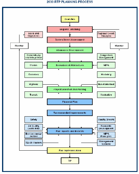
Figure 1: Flowchart from WFRC Regional Transportation Plan
The 2030 RTP planning process started with a series of meetings with planners and engineers from (UDOT and UTA who helped identify areas of concern and suggestions for specific transportation improvement projects. The information provided by these professionals was compiled and analyzed and was a factor in the determination of transportation needs. Additional meetings were scheduled with local elected officials and stakeholders. An extensive public outreach and visioning exercise was conducted with the help of planners at Envision Utah, which resulted in an adopted list of regional growth principles and a preferred land use and transportation network for the Wasatch Front. Envision Utah is a Public/Private Partnership that was formed in 1997 and its main function is to guide the development of a broadly and publicly supported Quality Growth Strategy - a vision to protect Utah's environment, economic strength, and quality of life for generations to come. The Partnership is made up of 130 key stakeholders, includes representatives from state and local government, business leaders, developers, conservationists, landowners and church and citizen groups from around the region. Their role is to provide the strength, knowledge and visibility to help develop and implement a Quality Growth Strategy for the Greater Wasatch Area. Utah's Governor Michael Leavitt and Spencer F. Eccles, Chairman of the Wells Fargo Intermountain Banking Region, serve as honorary co-chairs of the effort. Mayor Greg Bell of Farmington City is the active chair of Envision Utah. With Envision Utah’s support, three transportation scenarios eventually led to the development and refinement of three transportation system alternatives designed to meet regional needs that were integrated to the RTP transportation needs. A quantifiable comparison of projects helped determine which performed the best. An on-going effort to solicit public input helped guide the 2030 RTP effort. Finally, a quantifiable means of identifying highway and transit projects that best met regional needs was developed and tested. Once specific capacity improvements were identified, they were placed into one of three construction and funding phases according to their overall score.
Key Aspects of the Screening Process
Scope
The screening process occurs at multiple stages in the development of recommended projects from visioning, to planning, to programming. It is unique in that there is integration from the visioning process through project development and that principles determined in the visioning process are actually applied in the later stages.
Prior to the development of the 2030 RTP, the WFRC was awarded funding from multiple sources (FHWA, UDOT, Envision Utah) to develop the Wasatch Choices 2040 Land Use and Transportation Vision document (Vision document). Through the visioning exercise, the screening process is integrated with other planning activities, specifically land use. The alternatives at this stage are scenarios and not project or even transportation specific, but reflect the “vision” of what the transportation system should be within the region.
There were four scenarios developed in the Vision document; 1) Business as usual, 2) Transit Station Villages, 3) Interconnected Network of Complete Streets, and 4) Centers of Employment. The scenarios were examined against the transportation network to determine what effect each would have on the system and the needs that would arise for each. Through extensive public involvement in this effort, Regional Growth Principles were developed for integration into the 2030 RTP. The Vision Document was not completed prior to the start of the 2030 RTP development, however the workshops and the growth principles had been developed prior to the 2030 RTP. The first solution screening effort of determining transportation needs is directly related to these growth principles, as well as other traditional transportation factors and is the first stage in the screening process for the WFRC 2030 RTP.
Once the transportation needs were identified, three system-wide alternatives were developed:
- Vision Alternative– a combination of the earlier 2004-2030 RTP and the results from the Wasatch Choices 2040 visioning exercise.
- Freeway Alternative – a transportation system emphasizing freeway and freeway based bus rapid transit.
- Arterial Alternative – a system emphasizing arterials and arterial based streetcar.
The alternatives were evaluated and scored against 19 measures (see Metrics and Data section for a complete list). The Vision Alternative was selected and endorsed by the Regional Growth Committee and became the base system and framework to refine into the 2007-2030 RTP. Detailed information on the measures and the evaluation results can be found in Chapter 5 of the 2030 RTP.
The final stage of the screening process is the Project Selection and Phasing and the objective in this stage is to refine the system concept into a list of defined projects and to place time horizons on each. This was done for Highway Projects and Transit Projects, with each having separate selection and phasing criteria. For Highway Projects, traditional individual project measures were considered in defining a project characteristic and helped to define project width, length, functional class, general alignment, and interchange location. The Congestion Management Process (CMP) was applied to determine if any needs could be resolved through Travel System Management (TSM) or Travel Demand Management (TDM) strategies, such as signal coordination, access management, carpooling, telecommuting, etc. Those projects that had needs that could not be satisfied by TSM or TDM strategies were advanced and evaluated by local and UDOT scoring criteria.
The local scoring method used data from cost per delay per day (need), traffic volumes, volume per capacity, and growth principle factors to provide a score. Each factor was worth 25 points for a total of 100 points. The descriptions of the data used to provide the local scores are described in detail on page 114 of the 2030 RTP. The local criteria evaluation helped to refine projects and resulted in one of the set of rankings which were used to place the refined projects into the 2030 RTP phases. The UDOT Scoring Method consisted of scoring projects based upon average annual daily traffic, truck traffic, volume to capacity ratio, functional classification, growth rate, and the safety index. The rankings based on the UDOT Scoring Method were applied to all projects in the state, not just those in the WFRC region. These rankings would then be used by the Transportation Commission as guidance for project funding.
Communications
Agency Involvement
At the initiation of the 2030 RTP in August of 2006 and again March of 2007, after project recommendations were made, meetings were held with the government resource agencies and other interested parties. Representatives from each of the MPOs and UDOT attended the meetings.
The purpose of the initial meeting was to determine the needs and issues of each agency prior to the identification of the 2030 RTP’s recommended projects. The meeting was well attended with broad representation from four school and two water districts, the Bureau of Land Management, the Bureau of Reclamation, the U/S/ Forest Service, the Utah Division of Natural Resources, the Utah Division of Water Quality, the Utah Division of Solid and Hazardous Waste, the Utah Division of Air Quality, the U.S. Natural Resources and Soil Conservation Service, the Utah State Department of Parks and Recreation, the Federal Highway Administration, the Utah Trucking Association, and Weber Pathways (representing the bicycle and pedestrian interests).
The purpose of the second meeting was to discuss possible or potential mitigation measures of identified/recommended projects. The same agencies that attended the first meeting were also at the second. There were also agencies that attended the second meeting that were not at the first. They are: Utah State Division of State History, Utah State Division of Wildlife Resources, Utah Division of Water Resources, Intermountain Health Care, and the Salt Lake City Bicycle Committee and Safe Routes to School Advisory Committee.
The agency participation in these meetings was very successful; however it appears that the information from the agencies did not have much influence on the outcome of the selection of projects. The focus on the agency involvement in this regard was more on mitigation opportunities. The specific comments are recorded in Chapter 9 of the 2030 RTP with specific regard to mitigation opportunities, so this listing can be referenced when project specific studies are initiated.
Public Involvement
The WFRC solicited public participation and integrated oral and written comments received into the planning process. Through media outlets, massive emails, and website notifications, input for the 2030 RTP was requested from various groups. These groups included freight hauling organizations, Native American groups, low income advocates, minority organizations, senior citizens groups, community councils, city councils of governments, other government agencies, (at a stakeholders meeting organized by WFRC), environmental groups, disabled rights advocates, chambers of commerce, state legislators and the general public. The WFRC considered comments received from these groups and individuals in both the draft and final document. A summary of the public review process and record of public involvement in the 2030 RTP can be found in Appendix A of the 2030 RTP.
WFRC staff members made dozens of visits to private citizens and the organizations noted above in order to identify transportation related problems and issues, receive input on possible solutions to growing travel demand, develop a series of RTP alternatives, and solicit comment on the draft 2030 RTP document.
The WFRC, in partnership with the Mountainland Association of Governments and Envision Utah engaged the public in an 18 month visioning process to establish a ‘Vision of the Future for the Wasatch Front.’ The data achieved from this visioning effort was the utilized in the first phase of the selection screening process, the development of transportation needs. This was an extensive process with thirteen workshops, four open houses and over 1,000 participants from all parts of the community and government. The result of the process was a set of growth principles derived by consensus that have been adopted by the WFRC and most of its member entities. These growth principles, developed through an extensive public process, now guide the development of the RTP and are an excellent example of how the public involvement process influences policy.
Two series of open houses regarding the RTP update process were held in Salt Lake, Davis and Weber counties. The first series was for the “alternatives” phase of the RTP and was held during November 2006. The second series for the draft 2030 RTP was held during April and May 2007. Both series of public open houses were announced through notices and advertisements in local newspapers. Many local newspapers also ran news articles announcing the open houses and some sent reporters to the open houses to ‘cover the story.’ Also, approximately 2,000 e-mails were sent to the interested stakeholders on the WFRC mailing list who received electronic notice of the upcoming open houses with an invitation to attend. The public open houses to review and receive input on the three regional transportation alternatives were held in October and November 2006 and were well attended. These open houses served to gauge public opinion on the three draft alternatives that were developed as part of the 2030 RTP planning process. All comments were carefully summarized and responded to by staff. The last series of open houses, held during April and May 2007, presented the draft 2030 RTP for public review and comment. The WFRC staff compiled written comments and summarized verbal comments received from the public after each open house and prepared a written response to each concern. The comments were considered in the project selection process, if the agency and public input had direct information regarding a specific project.
All documents and maps regarding the RTP were made available on the WFRC website. Interested parties were invited to visit the website and review all comments on the documentation. Many e-mails received as comments on the draft 2030 RTP were from this source. In addition, as noted above, thousands of e-mails were sent out soliciting public review and comment.
Regular efforts to include the local news media in WFRC actions resulted in a number of articles about Wasatch Front Regional Council transportation planning efforts. Regional Council Chairman, Denis Nordfelt, and several WFRC staff members were quoted in news articles during the 2030 RTP development process.
The WFRC prepared a draft project lists and maps of the Wasatch Front Regional Transportation Plan: 2007-2030 in February 2007 for distribution to interested public agencies, elected officials, local communities, and the general public. A formal public review period was held during April and May 2007. Interested persons and groups were invited to review and offer comments on the draft 2030 RTP in either formalized public open houses, or individually at their convenience. The finalized document was reviewed and approved by the Wasatch Front Regional Council on May 24, 2007. Copies of the Wasatch Front Regional Transportation Plan: 2007-2030 are available through the Wasatch Front Regional Council office, the WFRC website, and select area libraries.
Technology
Four technology-centric software tools are used in the process, in addition to the common word-processing, spreadsheet, and communication tools of Microsoft Office. The tools are described below.
WFRC Website
WFRC's website (http://www.wfrc.org/cms/index.php) provides information about the Council, its contacts, activities, projects, schedule and accomplishments, and other general organizational information. It also provides links to partner organizations and MPOs, and to other web resources. Public project documents are available on the website. The public website has a built-in search engine and a Google-Earth location function. The principle function of the WFRC website is to serve as the WFRC public calendar, announcement board, contact sheet, and document repository.
Geographic Information System
WFRC has an in-house ESRI-based Geographic Information System (GIS). A GIS is a collection of computer hardware, software, and geographic data for capturing, managing, analyzing, and displaying all forms of geographically referenced information. WFRC has four seat licenses for GIS software, and a floating license. The GIS is or will be used throughout the process. It is a core technology and provides geographic products including maps, analysis and processed data to internal users, other agencies, and to the public upon request. The GIS routinely is used to create visuals for presentations, meetings, redline discussions, etc. GIS maps are presented in reports, etc.
GIS layers are provided through purchase of proprietary map layers from commercial sources, from ENVISION Utah's GIS for the state, from partnering MPOs and via the web without cost. The WFRC GIS staff creates layers either from scratch using GIS software, or from the UrbanSim model which generates layers as part of its modeling output. GIS data, processed layers, and new layers resulting from GIS analysis runs are exchanged amongst participating agencies, consultants and the public. Maps are shared and used in discussions to make decisions or show the results of urban and traffic growth projections.
GIS is used to develop and presented the cartographic and data representation of the urban and traffic demand model run results on common base maps. Thus alternative development and transportation scenarios can be depicted on a common base map and the results compare. In addition to graphically depicting the alternatives, the GIS can produce reports of the data for the alternatives, and can run any number of analysis exercises for any alternatives - for example, a query may be made of how many people live within walking distance of a proposed transit stop, or the drive-times of a new transportation network may be analyzed.
UrbanSim
-
UrbanSim is a software-based demographic and employment modeling tool for integrated planning and analysis of urban development, incorporating the interactions between land use, transportation, and public policy with demographic information. It is intended for use by MPOs and others needing to interface existing travel models with new land use forecasting and analysis capabilities. UrbanSim has many built-in GIS functions. UrbanSim was first utilized by WFRC to provide support to a litigation regarding the Legacy Parkway. Legacy Parkway is a controversial project in Salt Lake City to which legal action from community and environmental groups had been pursued. UrbanSim was customized and used during the RTP Planning phase completed in May 2007.
Travel Model
Travel Model is software that determines trip generation, trip distribution, mode choice, and trip assignments from a source of population distribution and employment information. Trip-based models typically represent each trip—such as an employee's trip from home to work, from work to home, etc. such that projected demands on a transportation network can be estimated. WFRC uses Travel Model with UrbanSim, and relies on GIS layers for the map data.
Overview
The three software tools (GIS, UrbanSim, and Travel Model) are used concurrently in the screening process, and the three tools pass information back and forth to each other - for example, GIS layers as modified were provided to UrbanSim, which in turn could modify the layer and port it back into the GIS as a new layer depicting a specific urban scenario. This powerful and flexible technology package, while not unique to this planning effort – it actually is fairly common – allows planners the ability to model future land use patterns and populations, create a travel model for the future community, and depict the results in tables and maps. Thus, alternative solutions can be created and evaluated during the selection process.
There is a great deal of effort involved to gather, cleanse and assemble the GIS and demographic data from the partnering organizations. Using a variety of sources, WFRC’s staff assembled a base data set that serves the area of study, and can be changed or updated in the future. This is an on-going effort, and must be completed before comprehensive modeling can begin.
UrbanSim, and to some extent Travel Model, require a dedicated, trained, medium-to-high level programming and modeler resource. It was estimated the effort to prepare for the RTP modeling was in the order of 2 full-time equivalent individuals for 2 years. In addition, each modeling run of UrbanSim took a week or more of programming and data preparation. The actual run time for an UrbanSim model was 72 continuous hours on one machine. Travel model runs took several hours to a day to run. This level of resource commitment and modeling time was acceptable, but did not allow for numerous runs or adjustments to the model.
Metrics and Data
Agency and Public data were used mainly in the identification of transportation needs. Once the transportation needs were identified, the alternative travel systems were evaluated against measures listed in Table 1.
Table 1: Measures used to Evaluate Alternative Travel Systems
Measures |
Definition* |
|---|---|
Construction Costs |
Estimated 2006 highway construction and major transit capital costs |
Transit Passenger Miles |
Number of miles traveled by transit passengers each day |
Vehicle Miles Traveled |
Total daily auto miles traveled |
Transit Proportion of Work and College Travel |
Proportion of all Home-based Work and Home-based College person trips taken by transit in the afternoon peak period |
Traffic Volumes in Constrained Critical Corridors |
Sum of all morning peak period auto volumes on all modeled street segments that fall within identified areas that have both severe congestion and a practical inability to widen roads |
Person Hours by Auto |
Total daily person hours spent in an automobile |
Weighted Transit Speeds |
Average perceived travel speed of all transit trips assuming that the time waiting for transit is perceived as twice as long as the time spent on the vehicle |
Home-based Work Auto Speeds |
Average speed of all auto trips between home and work on a daily basis |
Auto Delay |
Annual number of hours of auto delay caused by traffic congestion during the peak periods. |
Improvements to Geographic Choke Points |
Both the number of projects crossing regional geographical choke points and the peak period auto and transit seat capacity added by these projects |
Transit Access to Major Activity and Mixed-use Centers |
Sum of all households and jobs within 20 minutes transit travel time during the afternoon peak period of each of the identified major activity centers and mixed-use centers |
Auto Access to Major Activity, Mixed-use, and Infill Areas |
Sum of all households and jobs within 20 minutes automobile travel time during the afternoon peak period of each of the identified major activity centers, mixed-use centers, and infill areas |
Freight Center to Freeway Access |
Sum of individual afternoon peak period travel times, in minutes, between each of the largest freight centers and the nearest freeway |
Employment Access for Disadvantaged Populations |
Sum of all jobs within 20 minute auto and transit afternoon travel times of all Traffic Analysis Zones with a disproportionately high percentage of low income families, minorities, persons with disabilities, seniors, and households with no autos |
Households and Employment Potentially Impacted |
Number of households and jobs in each five acre grid cell adjacent to a roadway project |
Potential Impacts to Historic Neighborhoods |
Project miles bisecting US Census Block Groups which have a proportion of homes build prior to 1950 which is higher than the regional average |
Potential Impacts to Disadvantaged Populations |
Project miles bisecting a US Census Block Group with a disproportionately high percentage of low income families, minorities, persons with disabilities, seniors, and households with no autos |
Air Quality |
Tons of Nitrogen Oxide, Carbon Monoxide, and Volatile Organic Compounds emitted daily by transportation sources in winter conditions |
Potential Impacts to Environmentally Critical Lands |
Acres of steep slope, wildlife habitat, wetlands, streams, and lakeshores within 100 to 300 feet (depending upon facility type) of a project centerline |
|
*All transportation statistics are projected for the year 2030 |
|
|
*All transportation statistics are for travel within Weber, Davis, and Salt Lake Counties |
|
|
*Morning and afternoon peak periods are 6:00 am through 9:00 am and 3:00 pm through 6:00 pm |
|
After the selection of the Transportation System, the following individual project measures were considered in defining a project characteristic:
- Project traffic volume to highway capacity ratio,
- Extent to which project promotes interconnected streets,
- Any known regionally significant relocations or community impacts,
- Any serious known hazmat or natural disaster exposures,
- Any other known critical natural or cultural impacts, and
- Access to regionally significant priority growth areas.
Projects were further refined and measured against local and UDOT scoring measures which are summarized in Table 2.
Table 2: Local and UDOT Scoring Measures
Local Scoring Measures |
UDOT Scoring Measures |
|---|---|
2015 Cost per Delay per Day (Need) |
2005 AADT |
2025 Cost per Delay per Day (Need) |
2005 Truck AADT |
2030 Average Annual Daily Traffic (AADT) |
2005 Volume/Capacity |
2015 Traffic on 2012 Network (V/C) |
2030 Functional Classification |
2025 Traffic on 2015 Network (V/C) |
Growth Rate |
Growth Principles |
2001-2003 Safety Index |
Choke Point Alternative |
|
Degree Project Includes Transit |
|
Extent Right of Way Preserved |
|
Improved Access to Activity Centers, etc. |
Lessons Learned
Success Factors
There were several factors that contributed to the success of the WFRC process.
Public Participation
The process took into account the data obtained from the visioning effort which included 13 separate workshops with over a thousand public participants. The information gained at these workshops and through other public involvement exercises throughout the development of the 2030 RTP was a measure by which projects were developed and ultimately recommended.
Working Relationships between Agencies
The relationships between WFRC and other agencies were key in the success of the solutions screening process. By having agencies participate prior to the recommended projects being determined, allowed them to contribute the information and data could then be utilized in the determination of ultimate solutions. Also, the information gathered at the second meeting with the agencies, provided detailed information on mitigation opportunities to be utilized in later phases of a specific project. The relationship between WFRC and the other MPOs and UDOT was critical in the development of the Unified Plan, which aided in the prioritization of a statewide project list for use in funding by the UTAH legislature.
Use of Innovative Tools with Knowledgeable Staff
There were innovative tools utilized by the WFRC in the solutions screening process, which required expertise by the staff to gain the most useful and applicable data. The WFRC had staff on board knowledgeable in the technical tools, such as UrbanSim, ArcGIS, and Website, which allowed the screening process to be the most effective. The local scoring method was developed in house by WFRC staff, which contributed to the success of the solutions screening process in that the weights to the measures could be applied according to the specific needs of the region.
Financial Support
A true key to the success of the process was the visioning effort of Wasatch Choices 2040, which was approximately 300k and was funded by multiple agencies. This support allowed a true public process, which carried forward throughout the development of the 2030 RTP.
Key Innovations
There were several unique innovations used in the process that made it different from traditional methods.
- The high amount of public involvement, led to a tremendous amount of public comments, which were individually addressed throughout the process. Furthermore, the way the public was treated at the workshops as participants, not just as an audience, was something unique compared to traditional public involvement practices.
- The utilization of UrbanSim early in the process, was a unique feature that allowed consideration of land use principles before determination of transportation needs.
- The development and use of a scoring method to prioritize projects was a unique feature of the solutions screening process. The WFRC weighted the various metrics according to regional standards which when applied to the project solutions, generated the final list of prioritized projects.
- Finally, the sheer amount of data considered at this early stage of a project was a true innovation, compared to traditional planning studies. As shown in the metrics/measures section of this document, there were numerous detailed metrics for which the solutions were evaluated against. This level of detail in a regional planning effort is something unique to this process and generated solutions that were well supported with real data.
Barriers and Solutions
Analytical Barriers
Proprietary Data
Proprietary data has acquisition cost and limits on distribution. Budget concerns and some licensing issues meant budget had to reviewed, adjusted or augmented to acquire needed data. Usually the solution is to revise the budget with new or reserve funding, or find an alternative at low or no cost. Data purchase if un-budgeted can impact other aspects of the project.
Considering all Environmental Factors
Amongst some public participants, a perception was voiced that some environment aspects were not considered as important as other factors. The solution was to develop a system that assigned a weight to environmental factors and reviewed these with the public first, so that they may be considered in the project selection. The result was that a more balanced project ranking system was produced by considering environmental along with other factors and ranking.
Implementing the Plan
An implementation strategy is outlined in planning document, but it does not clearly define who is responsible and how it will be done (and funded). The development of the plan would have been considered a waste of money and time if not implemented properly. A loss of trust of participants could be severe if there was not certainty that what was said was actually done. Lawsuits could be filed if legal requirements are not met – i.e. statements of plan intent not carried out. The solution was to specify an Implementation Plan and set up funding to develop and monitor performance measures. WFRC also followed through with participants that made commitments (i.e. local government zoning changes). In the end the planning effort was realized and the participants and users of the system trusted that the work of WFRC was worthwhile.
Institutional Barriers
Resistance to Technical Tools
There was some resistance to the use of UrbanSim as a tool to model population and employment demographics across the region and from those projections create travel demand projects using Travel Model by planning agencies due to the granularity of the analysis - 150 meter grid, and it took additional time. WFRC stayed with the 150 meter grid and was able to convince players of its validity for the initial regional study, noting that a finer grid could be used for detailed work when required, thus the project was able to move forward.
Zoning Changes
In the Implementation phase, the Vision Plan could not be realized without the zoning changes the Plan recommended being enacted. This will require intense work at the individual MPO level, in order for the Vision to be realized to redirect growth. If zoning is not changed, the vision will not be realized.
Acceptance of Software Modeling Outputs
Not all modeling outputs would be accepted by all agencies. A consensus will not be reached if the same model cannot be applied across all jurisdictions. A solution might require a complete redo of the modeling effort, and this could mean a loss of momentum and funding to continue the study, resulting in growth continuing more or less at present rates and patterns.
Competing Jurisdictions have Incompatible Plans
Land use and transportation plans are inconsistent and discontinuous across the region. The solution is to develop a region-wide vision with unified growth principles and have all local government entities participate together throughout the entire process. All local planning efforts are coordinated with regional planning and reflect unified growth principles.
Competing MPOs
Multiple MPOs in the state have different goals and are competing for one block of money from legislature. The State Legislature may not be clear on how to prioritize projects and how to allocate and phase funding when faced with this issue. The solution was to create a Unified Transportation Plan through consultation with all MPOs and other areas not under an MPO and have the State DOT prioritize projects through a ranking system. One document comes to legislature with a clear prioritized project list for funding consideration. MPOs have initial projects with their own priorities, but the Unified Plan spells out the entire state's needs. Trust is built between MPOs thru this process.
Lack of Public Involvement
A public lacking awareness or education in the planning and land use process may demand unrealistic and unattainable goals. WFRC’s solution was to actively participate with the public through interactive workshops that put the responsibility on the public participants to find solutions within the same parameters presented to the project team. The outcome was the public was more supportive of realistic solutions and felt more a part of process.
Technical Barriers
Technical Incompatibilities Limit Transfer of UrbanSim and Travel Model
Other neighboring MPOs desire to use the same tools as the WFRC. The tools are hard-coded to specific modeling and data sets, and work with specific operating systems and databases. The tool will not transfer unless these items are identical. Only truly compatible systems can interchange the tool, and then the data must be the same format, etc. The ‘solution’ is extensive work that usually is not an acceptable level of effort. The ultimate solution, not available at this time, will be an advanced, agile version of these tools. The level of difficulty to transfer the tool remains a barrier at this time.
Lengthy and Technically Challenging Software Implementation Process
Modeling software - Urban UrbanSim and Travel Model - customization and implementation took 1 - 1.5 FTE to prepare for project modeling runs. Required 1) knowledgeable technical resource, 3) new workstations, 3) staff time, and 4) development time that reduced time available for actual project production. The required level of customization effectively turned the modeling staff into a coding shop for many months. Several staff worked as a development team to configure the software package for the project. Additional equipment & software purchased. Contractor support purchased. Impacted schedule until resource could be freed up. Locked solution into one software version - customized code cannot be moved forward into a newer version. Project schedule was met; however additional requests for scenario modeling could not be met due to time and resource constraints.
Length of Model Runs
The run time for modeling software package, UrbanSim and Travel Model, took approximately 72 hours. Such long time required staff monitoring time, tied up machines, and reduced the overall number of model scenarios that could be run. Also wasted time as a bad run would not be discovered until it was completed. There was no easy solution available. Extensive customization or a newer software version might have allowed faster processing or allowed distributed processing amongst several machines. Reduced available staff time and number or runs that could be performed in a given period.
Use of Customized Code
Customized code is unique to this project in terms of version of software and the specific functionality and data references written into the code. The customized code will not work with a newer version of the software. The customized code cannot be shared with other jurisdictions working other solutions. Solution was to freeze all software versions. The customized code will work only with the current software versions, including the operating system. Any significant upgrades will require a complete re-write effort. Customized code works, but will not work with later versions of software or operating systems.
Modeling Software - UrbanSim and Travel Model - Updates are not Usable
Newer versions of modeling software or operating system software probably will not run the current heavily-customized code without extensive rewrite. The solution is to stay with the current software versions until the project stage is completed. At some point later software versions may be evaluated. As long as all versions remain the same, solution will work.
Other Barriers
Project Schedule
The project schedule was mandated to meet regulatory requirements for RTP submission. Tight schedule made scheduling and completing all meetings, development and reviews problematic .WFRC realized they would not have time to get 100% buy-in or adoption of the Principles of the study. Therefore WFRC decided that asking participating agencies if they could 'live with the principles" would be sufficient buy-in to move forward. Agencies for the most part agreed to this. Project was able to move forward and meet schedule.
Multiple Meeting Scheduling and Staffing Conflicts
WFRC met with over 50 groups, 1000 individuals, numerous agencies, etc. during the visioning process. It was very difficult to get on everyone's schedule. If a traditional one-on-one meeting schedule had been adhered to, the process could not have been completed within the schedule. WFRC held open-house review meetings and invited multiple participants/players to attend at same time, thus compressing the schedule. They 'let the maps tell the story.' Schedule was met. In addition parties that otherwise might not have met or collaborated were drawn together around the shared vision, and worked as a more comprehensive group. This created a more participatory process.
Technical Staff Availability
The lead software modeler left WFRC, and left a technical and production gap. Increased workload on staff short-term and hired contractor assistance. Project was kept on schedule.
Recommendations
The selection process utilized by the WFRC is one that could be transferred to other agencies. The availability of critical resources, including financial, staffing, and innovative tools all were major factors in the success of the selection screening process. Specifically, the incorporation of public involvement as a key aspect of the visioning process led to the identification of project needs directly from the users of the system. These needs were the foundation of the project selection process and were critical to its success. The visioning process may be a financial barrier to agencies without its support from sponsors, so it is important that this is addressed in order for the agency to be successful in this process.
Another critical element to the ability of another agency to apply this process is whether they are able to obtain the numerous and detailed transportation data that WFRC applied to the selection screening process. As shown in the Measures section of this document, the amount of data involved in the selection screening process is enormous when compared to other agencies in similar stages in the planning process. The access to the specific software (i.e. UrbanSIM) and tools (i.e. Local Scoring Method) to obtain this data and the availability of staff to process the data are key factors in the transferability of the selection screening process. In addition, had a Data Model for highway planning been available, a large savings of staff effort and modeling run preparation time would have been realized. The term Data Model refers to the set of database standards, rules, datasets to be included and procedures that describe the actual structure of a database, and is typically prepared and reviewed prior to beginning actual database development. It is an essential step in the preparation of a project database.
Finally, support from the sponsors, agencies, and the public is integral to the success of the screening process. As shown in the example of the visioning process, the public support of the project and their input led to a true vision of the area to which the transportation needs were addressed. The effort by WFRC to involve the various resource agencies at numerous times during the process led to input on other projects in the area, sensitive areas to avoid, and mitigation opportunities…all which were consideration factors in the selection screening process. The support of UDOT and the local government agencies to assist in the effort and to provide buy-in to the process was also key to the selection process and to the implementation effort.
The solution screening process was multi-phased, utilized extensive data. Financial concerns could deter its use by another agency. However, if these barriers were overcome, its use, whether in part by using specific tools or in whole, would be highly recommended in other planning or project selection efforts.
Sources
- Wasatch Front Regional Transportation Plan 2007-2030 Technical Report, Wasatch Front Regional Council, (May 2007)
- Wasatch Choices 2040, A Four County Land Use and Transportation Vision, Utah Department of Transportation, (November 2006)
- Utah’s Unified Transportation Plan, Utah Department of Transportation, (July 2007)
- Personal Interview, senior level planner of Wasatch Front Regional Council, 8/27-28/2007.
- Personal Interview, mid level planner of Wasatch Front Regional Council, 8/27-28/2007.
- Personal Interview, IT representative of Wasatch Front Regional Council, 8/27-28/2007
- Personal Interview, representative of Utah Department of Transportation, 8/28/2007.
- Personal Interview, public stakeholder, 8/28/2007.
- Personal Interview, former planner of Wasatch Front Regional Council, 8/28/2007.
- Wasatch Front Regional Council website(http://www.wfrc.org)
- Envision Utah website (http://www.envisionutah.org)
- Utah Department of Transportation website (http://www.udot.utah.gov)