
US Department of Transportation
FHWA PlanWorks: Better Planning, Better Projects
US Department of Transportation
FHWA Planworks: Better Planning, Better Projects
Natural Environment and Implementing Eco Logical
Overview
Why do transportation practitioners care about the natural environment?
Federal regulations require transportation planners to "protect and enhance the environment." During environmental review, transportation practitioners must ensure their federally-funded projects comply with the National Environmental Policy Act (NEPA) and other environmental laws, and are permitted by resource agencies.
How can PlanWorks help transportation practitioners consider the natural environment?
PlanWorks provides tools to step up the level of collaboration among transportation practitioners and natural resource specialists to:- Avoid impacts on priority conservation areas
- Locate mitigation for the greatest benefit to multiple resources
- Better achieve the goals of resource protection laws
The goal is streamlined transportation decisions with better outcomes for the natural environment.
Four areas of information support this integration:
- Natural Environment and the Decision Guide is a quick, high-level, summary of how information about the natural environment informs transportation Key Decisions.
- The Integrated Ecological Framework (IEF) is a detailed, step-by-step, technical process that guides you through the integration of transportation and ecological planning.
- Linking the IEF and the Decision Guide shows how data, analysis, and decisions from the IEF inform transportation Key Decisions.
- Examples from Practice show how the IEF approach has been applied.
Decision Guide
Natural Environment and the Decision Guide
The Decision Guide is the foundation of Planworks.It consists of all of the Key Decisions in four phases of transportation decision making: long range planning,programming,corridor planning and environmental review. For each Key Decision Planworks provides:
- Purpose and outcome
- Data inputs
- Questions that decision makers ask
- Connections among transportation decision making and other processes (like ecological planning)
- Connections among the phases of transportation decision making
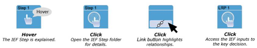
Hover over the highlighted Key Decisions to understand the specific relationship of natural environment to the decision. Click on any highlighted Key Decision for more information about questions, data, and relationships that support this interface. Key Decisions that are greyed-out have no specific relevance to the individual application or topic area but are still accessible from this graphic.
Approve Evaluation Criteria, Methods and Measures
Approve Transportation Deficiencies
This Key Decision is not associated with application.Make Conformity Determination by MPO
This Key Decision is not associated with application.Approve Project Cost and Revenue Allocation Approach
Approve Project List from Adopted Plan
This Key Decision is not associated with application.Approve Project Prioritization
Approve TIP by Governor and Incorporate into Draft STIP
This Key Decision is not associated with application.Approve STIP with respect to Fiscal Constraint
This Key Decision is not associated with application.Approve Scope of Corridor Planning Process
Approve Problem Statements and Opportunities
Approve Goals for the Corridor
Reach Consensus on Scope of Environmental Analysis
Approve Evaluation Criteria, Methods and Measures
Approve Range of Solution Sets
Approve Implementation Criteria for Prioritizing Projects
Adopt Priorities for Implementation
Reach Consensus on Scope of Environmental Review
Approve Purpose and Need/Reach Consensus on Project Purpose
Approve Evaluation Criteria, Methods and Measures
Approve Full Range of Alternatives
Approve Alternatives to be Carried Forward
Approve Draft EIS with Conceptual Mitigation
Approve Resource Agency Public Notice
This Key Decision is not associated with application.Approve Preferred Alternative / LEDPA
This Key Decision is not associated with application.Approve Final Jurisdictional Determination
Reach Consensus on Avoidance and Minimization for the LEDPA
Approve Final EIS and Record of Decision
This Key Decision is not associated with application.Render Permit Decision and Approve Avoidance and Minimization
Integrated Ecological Framework (IEF)
The IEF is a step-by-step, peer-reviewed, and science-based process that guides transportation and resource specialists in the integration of transportation and ecological decision making.
The IEF responds to two critical needs:
- Identify potential impacts on regulated resources very early in the planning process so they can be avoided or minimized.
- Assure that any mitigation that must occur will provide effective, measurable, and high-quality environmental outcomes.
The IEF process addresses key questions:
- What areas and resources will be directly impacted by transportation?
- What are the cumulative impacts on those resources?
- What areas could be used for mitigation? Which areas would maximize benefits for multiple resources?
- Can anticipated long-range mitigation needs for a region be combined to maximize ecological benefits instead of project-by-project mitigation?
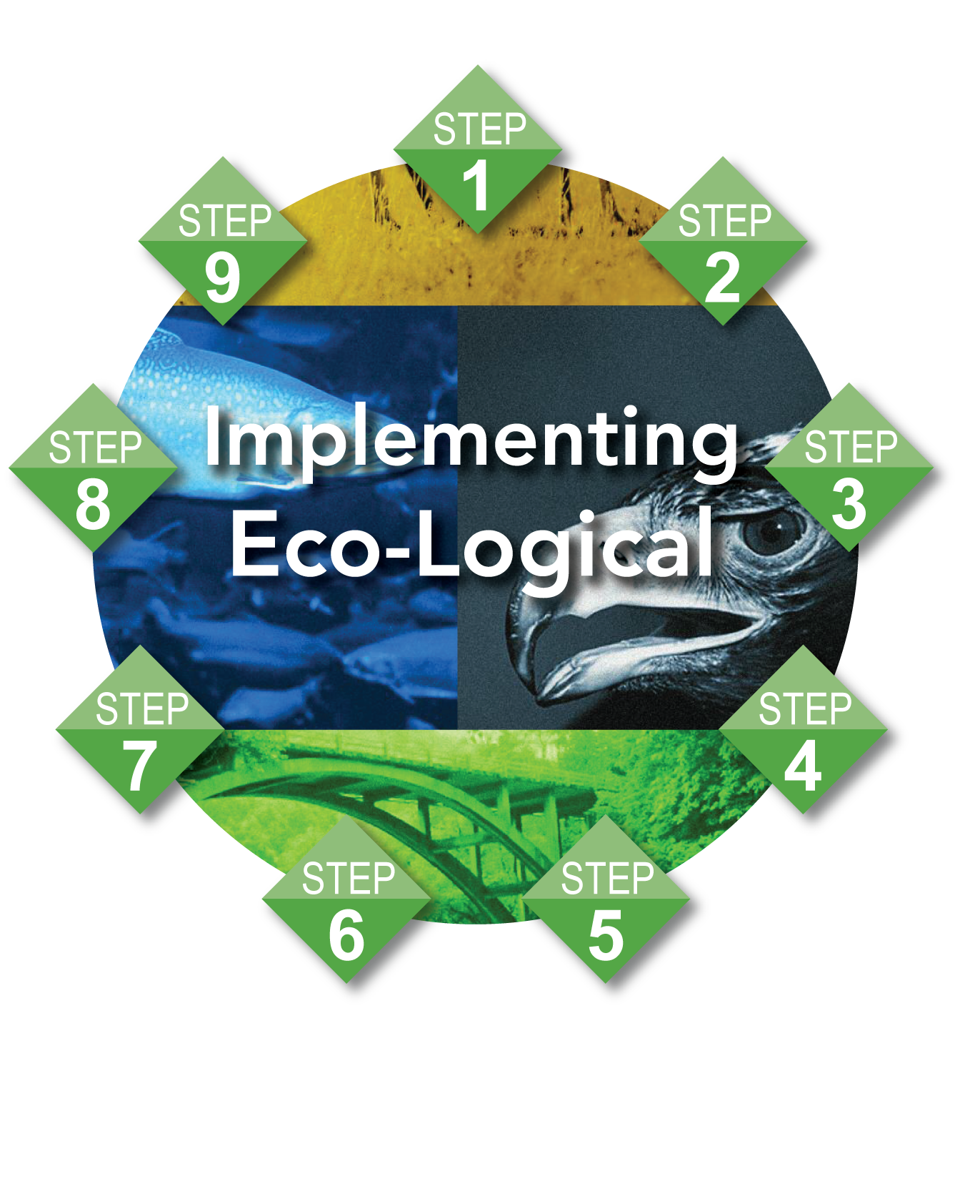
The nine steps in the IEF are depicted below. Hover over each step to discover its purpose. Click on a step to access detailed information about implementation,including: anticipated outcomes; sub-steps; technical guidance; and supporting tools,decision-making questions, data and case studies.
Integrated Ecological Framework
Linking the IEF and the Decision Guide
The IEF represents the technical process of integrating transportation and ecological planning. IEF steps and Key Decisions are linked through the two-way flow of data, analysis, and decisions.
Ideally, the IEF process is conducted in conjunction with long range planning. However, it is possible to begin at any Key Decision and use the IEF to support better environmental and transportation decision making.
A printable summary, An Ecological Approach to Integrating Conservation and Highway Planning, Volume 1, is available on the web.
Integrated Ecological Framework
Render Permit Decision and Approve Avoidance and Minimization

Examples from Practice
Several examples from practice show how transportation and resource agencies have tested and implemented the IEF process. These include three pilot projects in Colorado, Oregon, and Michigan summarized on this page.
-
Colorado Pilot Project: South I-25 Corridor
Steps 1-5 of the IEF process were used to identify priority natural resource areas,avoid impacts, and select mitigation for the South I-25 Corridor in the Denver,Colorado area. An EIS for the South I-25 Corridor had been completed and results were compared to the pilot approach. The IEF approach promoted a more accurate assessment of cumulative impacts by including spatially explicit analyses using data not included in the original assessment, and by defining a larger, ecologically based assessment area.
Step 1: Build & Strengthen Collaborative Partnerships and Vision
Pilot efforts were focused on Step 1a - identify a preliminary planning region.The pilot project is within the Denver Regional Council of Governments (DRCOG) planning area. The DRCOG spans two very different eco-regions: the forested, mountainous areas of the Southern Rockies and the remaining fragments of the Shortgrass Prairie.The boundary used for the analysis was the Shortgrass Prairie portion of the DRCOG area.Step 2: Characterize Resource Status and Integrate Natural Resource Plans
Existing sources provided spatial data representing baseline conditions. Data from DRCOG captured changes in transportation, urban growth, and other planned infrastructure at a landscape scale. Natural resources data included key wildlife areas, natural heritage occurrences, priority conservation areas, wildlife corridors and highway crossing areas, and wetlands. NatureServe Vista was used to combine all layers representing land use into three broad categories: species occurrences, natural communities,and priority conservation areas.Step 3: Create Regional Ecosystem Framework
To spatially represent the source, type, and magnitude of current and anticipated transportation impacts, pre-construction and post-construction scenarios were identified.NatureServe Vista was used to compare resources in both scenarios and view the results against predetermined resource retention goals.Step 4: Assess Effects on Conservation Objectives
The scenario evaluation produced a report and several visualization layers. The report summarizes the performance of each scenario in terms of the number of acres and percentage of resources that met conservation goals. The raster layers identified locations where natural resources intersect with potentially harmful land uses.The tool identified the expected direct impacts of the South I-25 Corridor and the cumulative impacts of the corridor project when combined with other infrastructure projects and anticipated land use changes.Step 5: Establish & Prioritize Ecological Actions
NatureServe Vista's Site Explorer was used to examine the effects of alternative land uses and policies on a site or set of sites. It provides an inventory of natural resources, the number and percentage of compatible occurrences, and the achievement of resource retention goals, with which transportation planners can develop multiple alternate off-site mitigation scenarios that meet goals and can be shared with stakeholders and decision makers. -
Oregon Pilot Project: US 20 Pioneer Mountain to Eddyville
Steps 1-6 of the IEF process were used to identify priority natural resource areas, avoid impacts, and select mitigation for improvements to a section of US 20 between Pioneer Mountain and Eddyville in Oregon. An EIS for the US 20 project had been completed and results were compared to the pilot approach. The IEF process recommended mitigation in larger priority-wetland areas in the watershed that would provide opportunities to create or enhance salmon habitat.
Step 1: Build & Strengthen Collaborative Partnerships and Vision
Pilot efforts were focused on Step 1a - identify a preliminary planning region.The project is in the Oregon Coast Range within the Yaquina River watershed. The relatively small Yaquina watershed was selected for analysis, allowing for a focused look at species, habitats, and impacts.Step 2: Characterize Resource Status and Integrate Natural Resource Plans
The ecological resources to be considered in the analysis were "adopted" from analyses available from the Oregon Biodiversity Information Center. This included data for at-risk species, habitats, and vegetation and from two regional assessments and one watershed assessment. Salmon are the only federally listed aquatic species present in the site and managed by NOAA Fisheries. NOAA provided Internal models of fish habitat presence and importance.Steps 3 and 4: Create Regional Ecosystem Framework and Assess Effects on Conservation Objectives
ArcGIS and the Envision DSS tools were used to create the REF and assess effects.Because the ecological targets within the transportation project area were limited,the focus of the analysis was on the changes in the particular species and habitats,based on the project area footprint.
The conservation assessment identified two significant habitats in the region affected by the project: coastal Sitka spruce forest and dry Douglas-fir forest. Moving the highway out of the Yaquina River watershed into young upland forest that had recently been clear-cut achieved as much conservation benefit as would be possible by a highway project in the basin.Step 5: Establish & Prioritize Ecological Actions
The pilot revealed that the onsite wetlands proposed as mitigation in the project EIS were not high-priority wetlands. Using the data and methods of this project,three high-priority wetland sites in the basin were identified as suitable mitigation,based on their size and overall importance to the at-risk fish in the watershedStep 6: Develop Crediting Strategy
Existing tools were used to evaluate the potential credits from two of the three potential mitigation sites. Pilot staff determined that the lands already in conservation ownership had little priority for restoration, while the private lands in these sites had significant potential, and would easily meet project mitigation needs.The crediting analysis included analysis of regulated resource crediting, analysis of credit markets, and recommendations based on future needs -
Michigan Pilot Project: US 131 Corridor
The goals of this pilot were to evaluate the efficacy of the IEF when applied to an alternative corridor assessment; evaluate NatureServe Vista's efficacy for building an REF without a spatially based local, regional, or statewide conservation plan in place; and evaluate the efficacy of utilizing several wetland datasets for mitigation.The IEF approach was compared to a 1997 corridor analysis for US 131. The IEF process indicated a different alternative that had fewer impacts and would have reduced mitigation requirements. The IEF's use of more detailed ecological data and a decision support tool that allowed for a very precise and quantitative impact assessment for each resource made the difference.
Step 1: Build & Strengthen Collaborative Partnerships and Vision
Pilot efforts were focused on Step 1a - identify a preliminary planning region.The US 131 Corridor is within the St. Joseph River watershed. A watershed approach was already being used to develop a wetland functional assessment database and was therefore adopted to define the planning region for this study.Step 2: Characterize Resource Status and Integrate Natural Resource Plans
Spatial data used to identify conservation priorities in the region comprised federal and state listed species, rare and/or exemplary natural communities, large contiguous natural landscapes, potential high quality natural vegetation patches, potential unique or high quality lakes, potential unique or high quality stream segments,and existing wetland functions.
All data layers were imported into Vista as individual conservation elements in a simple overlay without weights. The results showed that conservation values differ significantly from place to place within the pilot region, and that the majority of natural resources are highly fragmented and scattered across the landscape.Step 3: Create Regional Ecosystem Framework
The 1997 corridor study of five alternatives was used as the transportation plan to determine which alternative corridor would have the least impact on the region's natural resources. The five 1-mile wide corridors analyzed were incorporated into Vista as five different scenarios.Step 4: Assess Effects on Conservation Objectives
Each corridor was evaluated to measure its impact on each of the resource types.The GIS analysis showed that Corridors A and B would have the least negative impact on the priority conservation areas in the pilot region, but Corridor B performed slightly better overall. Yet Corridor A had been chosen in the original corridor study. The Vista tool and the accompanying natural resource data allowed relatively quick analysis. If these had been available for the original US 131 corridor study, environmental concerns may have been addressed more easily and earlier in the decision making process.
More examples
The Eco-Logical website also contains the two case studies listed below, as well as Annual Reports and Successes documents and a comprehensive library with resources for transportation and resource agencies. The following are case studies that focus on specific steps of the IEF:
-
Charlottesville-Albemarle MPO: Steps 1-4. The Charlottesville Albemarle MPO (CA-MPO) and its parent organization, the Thomas Jefferson Planning District Commission (TJPDC), implemented steps 1-4 of the nine-step Eco-Logical approach in the Charlottesville, Virginia area. As part of their project, TJPDC and CA-MPO developed a Regional Ecosystem Framework (REF) to help screen potential transportation projects and identify mitigation priorities and engaged stakeholders in the evaluation of project alternatives for the Free Bridge Area Congestion Relief Project.
-
Colorado Department of Transportation: Steps 7-9. The Colorado Department of Transportation (CDOT) implemented steps 7-9 of the nine-step Eco-Logical approach. CDOT used Eco-Logical to guide mitigation projects and wildlife connectivity along the 144-mile Interstate 70 Mountain Corridor in Colorado. As part of its project, CDOT developed a project-level REF over approximately 3 years, finalized a Programmatic Environmental Impact Statement using the REF, and established two Memoranda of Understanding (MOUs) with its partners.